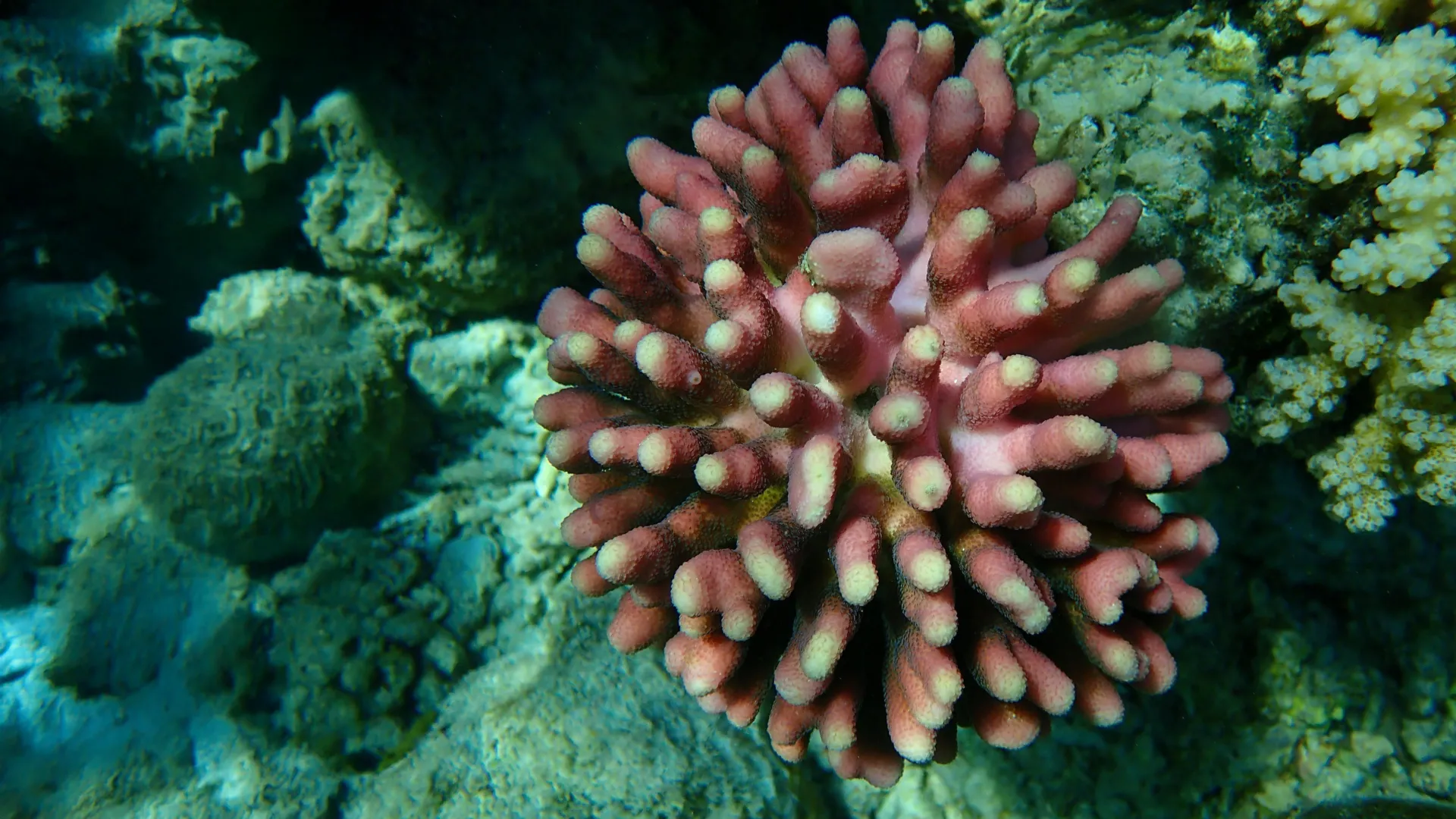
The ancient oxygen flood that forever changed life in the oceans

Source:Duke University

Summary:Ancient forests may have fueled a deep-sea oxygen boost nearly 390 million years ago, unlocking evolutionary opportunities for jawed fish and larger marine animals. New isotopic evidence shows that this permanent oxygenation marked a turning point in Earth’s history — a reminder of how fragile the ocean’s oxygen balance remains today.Share:


FULL STORY


Ancient Oxygen Flood Changed Life Forever
An artist’s rendering of a prehistoric jawed fish from the Late Devonian called Dunkleosteus. These sorts of large, active vertebrates evolved shortly after the deep ocean became well-oxygenated. Credit: © 2008 N. Tamura/CC-BY-SA

Some 390 million years ago in the ancient ocean, marine animals began colonizing depths previously uninhabited. New research indicates this underwater migration occurred in response to a permanent increase in deep-ocean oxygen, driven by the aboveground spread of woody plants — precursors to Earth’s first forests. 

That rise in oxygen coincided with a period of remarkable diversification among fish with jaws — the ancestors of most vertebrates alive today. The finding suggests that oxygenation might have shaped evolutionary patterns among prehistoric species.

“It’s known that oxygen is a necessary condition for animal evolution, but the extent to which it is the sufficient condition that can explain trends in animal diversification has been difficult to pin down,” said co-lead author Michael Kipp, assistant professor of earth and climate sciences in the Duke University Nicholas School of the Environment. “This study gives a strong vote that oxygen dictated the timing of early animal evolution, at least for the appearance of jawed vertebrates in deep-ocean habitats.”

For a time, researchers thought that deep-ocean oxygenation occurred once at the beginning of the Paleozoic Era, some 540 million years ago. But more recent studies have suggested that oxygenation occurred in phases, with nearshore waters first becoming livable to breathing organisms, followed by deeper environments.

Kipp and colleagues homed in on the timing of those phases by studying sedimentary rocks that formed under deep seawater. Specifically, they analyzed the rocks for selenium, an element that can be used to determine whether oxygen existed at life-sustaining levels in ancient seas. 

In the marine environment, selenium occurs in different forms called isotopes that vary by weight. Where oxygen levels are high enough to support animal life, the ratio of heavy to light selenium isotopes varies widely. But at oxygen levels prohibitive to most animal life, that ratio is relatively consistent. By determining the ratio of selenium isotopes in marine sediments, researchers can infer whether oxygen levels were sufficient to support animals that breathe underwater.

Working with research repositories around the world, the team assembled 97 rock samples dating back 252 to 541 million years ago. The rocks had been excavated from areas across five continents that, hundreds of millions of years ago, were located along the outermost continental shelves — the edges of continents as they protrude underwater, just before giving way to steep drop-offs.

After a series of steps that entailed pulverizing the rocks, dissolving the resulting powder and purifying selenium, the team analyzed the ratio of selenium isotopes that occurred in each sample.

Their data indicated that two oxygenation events occurred in the deeper waters of the outer continental shelves: a transient episode around 540 million years ago, during a Paleozoic period known as the Cambrian, and an episode that began 393-382 million years ago, during an interval called the Middle Devonian, that has continued to this day. During the intervening millennia, oxygen dropped to levels inhospitable to most animals. The team published their findings in Proceedings of the National Academy of Sciences in August.

“The selenium data tell us that the second oxygenation event was permanent. It began in the Middle Devonian and persisted in our younger rock samples,” said co-lead author Kunmanee “Mac” Bubphamanee, a Ph.D. candidate at the University of Washington.

That event coincided with numerous changes in oceanic evolution and ecosystems — what some researchers refer to as the “mid-Paleozoic marine revolution.” As oxygen became a permanent feature in deeper settings, jawed fish, called gnathostomes, and other animals began invading and diversifying in such habitats, according to the fossil record. Animals also got bigger, perhaps because oxygen supported their growth.

The Middle Devonian oxygenation event also overlapped with the spread of plants with hard stems of wood.

“Our thinking is that, as these woody plants increased in number, they released more oxygen into the air, which led to more oxygen in deeper ocean environments,” said Kipp, who began this research as a Ph.D. student at the University of Washington.

The cause of the first, temporary oxygenation event during the Cambrian is more enigmatic.

“What seems clear is that the drop in oxygen after that initial pulse hindered the spread and diversification of marine animals into those deeper environments of the outer continental shelves,” Kipp said.

Though the team’s focus was on ancient ocean conditions, their findings are relevant now.

“Today, there’s abundant ocean oxygen in equilibrium with the atmosphere. But in some locations, ocean oxygen can drop to undetectable levels. Some of these zones occur through natural processes. But in many cases, they’re driven by nutrients draining off continents from fertilizers and industrial activity that fuel plankton blooms that suck up oxygen when they decay,” Kipp said.

“This work shows very clearly the link between oxygen and animal life in the ocean. This was a balance struck about 400 million years ago, and it would be a shame to disrupt it today in a matter of decades.”

Funding: MAK was supported by an NSF Graduate Research Fellowship and Agouron Institute Postdoctoral Fellowship. Additional support was provided by the NASA Astrobiology Institute’s Virtual Planetary Laboratory.

CLICK HERE FOR MORE INFORMATION

https://www.sciencedaily.com/releases/2025/08/250827010726.htm

Wildfires threaten water quality for up to eight years after they burn

A study of 100,000 water samples from 500 river basins found elevated levels of contaminants persist for years after a fire.

Source:University of Colorado at Boulder

Summary:Wildfires don’t just leave behind scorched earth—they leave a toxic legacy in Western rivers that can linger for nearly a decade. A sweeping new study analyzed over 100,000 water samples from more than 500 U.S. watersheds and revealed that contaminants like nitrogen, phosphorus, organic carbon, and sediment remain elevated for up to eight years after a blaze.Share:


FULL STORY


Wildfires Leave Rivers Polluted for 8 Years
Wildfires leave a hidden trail: rivers tainted by long-lasting pollution. New research shows water contamination can linger up to eight years, with storms often triggering delayed surges of toxic runoff. Credit: Shutterstock

Years after wildfires burn forests and watersheds, the contaminants left behind continue to poison rivers and streams across the Western U.S. — much longer than scientists estimated.

A new study, published on June 23 in Nature Communications Earth & Environment, analyzed water quality in more than 500 watersheds across the Western U.S., and is the first large-scale assessment of post-wildfire quality.

The research was led by scientists from the Cooperative Institute for Research in Environmental Science (CIRES) at the University of Colorado Boulder.

“We were attempting to look at notable trends in post-wildfire water quality across the entire U.S. West, to help inform water management strategies in preparing for wildfire effects,” said Carli Brucker, lead author and former CU Boulder and Western Water Assessment PhD student.

The results showed contaminants like organic carbon, phosphorus, nitrogen, and sediment can degrade water quality for up to eight years after a fire. Water managers can use this data to help them plan for the future and respond appropriately when wildfires strike.

CIRES Fellow and Western Water Assessment Director Ben Livneh was the principal investigator and co-author of the study. Much of his research focuses on hydrology, or water supply, on a continental scale. When he realized he could use the same approach to understand large-scale trends in water quality, he was excited to test the method.

“There’s been a lot of work, for example, in the National Climate Assessment and the International Panel on Climate Change talking about changes in global water supply,” said Livneh, associate professor in the Department of Civil, Environmental and Architectural Engineering. “But those assessments point to this gap in water quality assessments in a continental scale context, whereas people like me in physical hydrology have been thinking about the continental scale challenges for a while.”

Researchers have long known that fire ash and soil destruction contribute to degraded water quality. Yet, past research has largely been limited to state and municipal studies — cities and towns test water quality in local streams and rivers following large fires.

For the new study, the team analyzed more than 100,000 water samples from 500 sites: half from burned river basins and half from unburned. They measured levels of organic carbon, nitrogen, phosphorus, and sediment as well as turbidity, or cloudiness, of each sample.

To understand wildfire-driven impacts, the team built data-driven models to measure how much contaminants changed in each basin before and after wildfires. In the final step, they compiled data to find the average across the burned basins for each pre- and post-wildfire year, and then compared those to the unburned basins.

The results showed watersheds take longer to recover after wildfires than previous studies found. Organic carbon, phosphorus, and turbidity are significantly elevated in the first one to five years post-fire. Nitrogen and sediment show significant increases up to eight years post-fire. Fire-driven impacts were worse in more forested areas.

“It can take two years, up to eight years, for the effect to be fully felt,” Livneh said. “Sometimes it can be a delayed effect, meaning, it’s not all happening right away, or sometimes you need a big enough storm that will mobilize enough of the leftover contaminants.”

Each watershed in the study felt the impacts differently. This is likely tied to where the fire struck — a fire closer to the river would be worse than an upstream fire. Different soils, vegetation, and weather also change the impact in each watershed, making it difficult to plan for the future.

“There’s a huge amount of variability in sedimentation rates,” said Brucker, who now works as a consultant. “Some streams are completely clear of sediment after wildfires, and some have 2000 times the amount of sediment.”

Despite variability across river basins, the study provides concrete numbers that give insight to water managers across the Western U.S. Researchers hope the results provide better direction on informing future planning efforts for increasing wildfire resilience.

“I’m hoping that providing concrete numbers is very impactful to water managers,” Brucker said. “You can’t fund resilience improvements on general concerns alone. Water managers need real numbers for planning, and that’s what we’re providing,” Brucker said.

CLICK HERE FOR MORE INFORMATION

https://www.sciencedaily.com/releases/2025/06/250624044332.htm#google_vignette

Protected seas help kelp forests bounce back from heatwaves

Date:August 20, 2025

Source:British Ecological Society

Summary:Kelp forests bounce back faster from marine heatwaves when shielded inside Marine Protected Areas. UCLA researchers found that fishing restrictions and predator protection strengthen ecosystem resilience, though results vary by location.Share:


FULL STORY


Protected Seas Help Kelp Forests Bounce Back
Marine Protected Areas give kelp forests a recovery edge after heatwaves, showing that local protections can buffer global climate pressures. Credit: Shutterstock

New research finds that Marine Protected Areas can boost the recovery of globally important kelp forests following marine heatwaves. The findings are published in the British Ecological Society’s Journal of Applied Ecology.

Using four decades of satellite images, University of California, Los Angeles (UCLA) researchers have looked at impacts Marine Protected Areas (MPAs) are having on kelp forests along the coast of California.

They found that although the overall effect of MPAs on kelp forest cover was modest, the benefits became clear in the aftermath of marine heatwaves in 2014-2016, when kelp forests within MPAs were able recover more quickly, particularly in southern California.

“We found that kelp forests inside MPAs showed better recovery after a major climate disturbance compared to similar unprotected areas.” Explained Emelly Ortiz-Villa, lead author of the study and a PhD researcher at UCLA Department of Geography.

“Places where fishing is restricted and important predators like lobsters and sheephead are protected saw stronger kelp regrowth. This suggests that MPAs can support ecosystem resilience to climate events like marine heatwaves.”

Professor Rick Stafford, Chair of the British Ecological Society Policy Committee, who was not involved in the study said: “It’s great to see these results and they clearly show that local action to protect biodiversity and ecosystem function can help prevent changes caused by global pressures such as climate change.

“However, it also demonstrates the need for effective MPAs. In this study, all the MPAs examined regulated fishing activity, and this is not the case for many sites which are designated as MPAs worldwide – including many in the UK.”

Kelp forests: a globally important and threatened ecosystem

Kelp forests our found around coastlines all over the world, particularly in cool, temperate waters such as the pacific coast of North America, The UK, South Africa, and Australia.

These complex ecosystems are havens for marine wildlife, including commercially important fish, and are one of the most productive habitats on Earth. They’re also efficient in capturing carbon and protect coastlines by buffering against wave energy.

However, kelp forests across the west coast of North America have declined in recent yeadue to pressures such as marine heatwaves, made more frequent and intense with climate change, and predation from increasing numbers of sea urchins, which have benefitted from population collapses of sea stars, which predate them.

Kyle Cavanaugh, a senior author of the study and professor in the UCLA Department of Geography and Institute of the Environment and Sustainability said: “Kelp forests are facing many threats, including ocean warming, overgrazing, and pollution. These forests can be remarkably resilient to individual stressors, but multi-stressor situations can overwhelm their capacity to recover. By mitigating certain stressors, MPAs can help enhance the resilience of kelp.”

Marine protected areas as a conservation tool

MPAs are designated areas of the ocean where human activity is limited to support ecosystems and the species living there. However, protections vary widely and while some areas are no-take zones, others have few restrictions or lack comprehensive management and enforcement. Many even allow destructive practices like bottom trawling.

Effective MPAs form a key part of the Kunming-Montreal Global Biodiversity Framework, agreed at COP15 in 2022, which commits nations to protecting at least 30% of oceans and land by 2030.

“Our findings can inform decisions about where to establish new MPAs or implement other spatial protection measures.” said Kyle Cavanaugh. “MPAs will be most effective when located in areas that are inherently more resilient to ocean warming, such as regions with localized upwelling or kelp populations with higher thermal tolerance.”

Emelly Villa added: “Our findings suggest that kelp forests could be a useful indicator for tracking the ecological health and climate resilience of protected areas and should be included in long-term monitoring strategies.”

Measuring the impact of marine protected areas

To understand the effects MPAs were having on kelp, the researchers used of satellite data from 1984-2022 to compare kelp forests inside and outside of 54 MPAs along the California coast.

By matching each MPA with a reference site with similar environmental conditions, they were able to test whether MPAs helped kelp forests resist loss or recover from extreme marine heatwaves which took place in the North pacific between 2014 and 2016.

The researchers warn that while their findings show that MPAs can help kelp recovery after marine heatwaves, the effect was highly variable depending on location.

“On average, kelp within MPAs showed greater recovery than in the reference sites. However, not all MPAs outperformed their corresponding reference sites, suggesting that additional factors are also play a role in determining resilience.” said Kyle Cavanaugh.

The researchers say that future work could look to identify these factors to better understand where and when MPAs are most effective at enhancing kelp resilience.

CLICK HERE FOR MORE INFORMATION

https://www.sciencedaily.com/releases/2025/08/250820000805.htm#google_vignette

Scientists reveal how just two human decisions rewired the Great Salt Lake forever

Utah geoscientist’s analysis of carbon and oxygen isotopes documents profound human-driven changes arising from agriculture and rail causeway.

Source: University of Utah

Summary:Scientists found that Great Salt Lake’s chemistry and water balance were stable for thousands of years, until human settlement. Irrigation and farming in the 1800s and a railroad causeway in 1959 created dramatic, lasting changes. The lake now behaves in ways unseen for at least 2,000 years.Share:


FULL STORY


Two Human Decisions Rewired the Great Salt Lake
The view of Great Salt Lake’s North Arm from Gunnison Island, which has long served as a nesting ground for pelicans. Credit: Brian Maffly, University of Utah

Over the past 8,000 years, Utah’s Great Salt Lake has been sensitive to changes in climate and water inflow. Now, new sediment isotope data indicate that human activity over the past 200 years has pushed the lake into a biogeochemical state not seen for at least 2,000 years.

A University of Utah geoscientist applied isotope analysis to sediments recovered from the lake’s bed to characterize changes to the lake and its surrounding watershed back to the time the lake took its current shape from the vast freshwater Lake Bonneville that once covered much of northern Utah.

“Lakes are great integrators. They’re a point of focus for water, for sediments, and also for carbon and nutrients,” said Gabriel Bowen, a professor and chairman of the Department of Geology & Geophysics. “We can go to lakes like this and look at their sediments and they tell us a lot about the surrounding landscape.”

Sedimentary records provide context for ongoing changes in terminal saline lakes, which support fragile, yet vital ecosystems, and may help define targets for their management, according to Bowen’s new study, published last month in Geophysical Research Letters.

This research helps fill critical gaps in the lake’s geological and hydrological records, coming at a time when the drought-depleted level of the terminal body has been hovering near its historic low.

“We have all these great observations, so much monitoring, so much information and interest in what’s happening today. We also have a legacy of people looking at the huge changes in the lake that happened over tens of thousands and hundreds of thousands of years,” Bowen said. “What we’ve been missing is the scale in the middle.”

That is the time spanning the first arrival of white settlers in Utah but after Lake Bonneville receded to become Great Salt Lake.

By analyzing oxygen and carbon isotopes preserved in lake sediments, the study reconstructs the lake’s water and carbon budgets through time. Two distinct, human-driven shifts stand out:

  • Mid-19th century – Coinciding with Mormon settlement in 1847, irrigation rapidly greened the landscape around the lake, increasing the flow of organic matter into the lake and altering its carbon cycle.
  • Mid-20th century – Construction of the railroad causeway in 1959 disrupted water flow between the lake’s north and south arms, which turned Gilbert Bay from a terminal lake to an open one that partially drained into Gunnison Bay, altering the salinity and water balance to values rarely seen in thousands of years.

The new study examines two sets of sediment cores extracted from the bed of Great Salt Lake, each representing different timescales. The top 10 meters of the first core, drilled in the year 2000 south of Fremont Island, contains sediments washed into the lake up to 8,000 years ago.

The view of the Great Salt Lake from Gunnison Island, which has long served as a nesting ground for pelicans. Credit: Brian Maffly

The other samples, recovered by the U.S. Geological Survey, represent only the upper 30 centimeters of sediments, deposited in the last few hundred years.

“The first gives us a look at what was happening for the 8,000 years before the settlers showed up here,” Bowen said. “The second are these shallower cores that allow us to see how the lake changed after the arrival of the settlers.”

Bowen subjected these lakebed sediments at varying depths to an analysis that determines isotope ratios of carbon and oxygen, shedding light on the landscape surrounding the lake and the water in the lake at varying points in the past.

“The carbon tells us about the biogeochemistry, about how the carbon cycles through the lake, and that’s affected by things like weathering of rocks that bring carbon to the lake and the vegetation in the watershed, which also contributes carbon that dissolves into the water and flows to the lake,” he said.

Bowen’s analysis documented a sharp change in carbon, indicating profound changes that coincided with the arrival of Mormon pioneers in the Salt Lake Valley, where they introduced irrigated agriculture to support a rapidly growing community.

“We see a big shift in the carbon isotopes, and it shifts from values that are more indicative of rock weathering, carbon coming into the lake from dissolving limestone, toward more organic sources, more vegetation sources,” Bowen said.

The new carbon balance after settlement was unprecedented during the 8,000 years of record following the demise of Lake Bonneville.

Next, Bowen’s oxygen isotope analysis reconstructed the lake’s water balance over time.

“Essentially, it tells us about the balance of evaporation and water inflow into the lake. As the lake is expanding, the oxygen isotope ratio goes down. As the lake shrinks, it goes up, basically telling us about the rate of change of the lake volume. We see little fluctuations, but nothing major until we get to 1959.”

That’s the year Union Pacific built a 20-mile causeway to replace a historic rail trestle, dividing the lake’s North Arm, which has no tributaries, from its South Arm, also known as Gilbert Bay, which receives inflow from three rivers. Water flows through a gap in the causeway into North Arm, now rendering the South Arm an open system.

“We changed the hydrology of the lake fundamentally and gave it an outflow. We see that really clearly in the oxygen isotopes, which start behaving in a different way,” he said. Counterintuitively, the impact of this change was to make Gilbert Bay waters fresher than they would have been otherwise, buying time to deal with falling lake levels and increasing salinity due to other causes.

“If we look at the longer time scale, 8,000 years, the lake has mostly been pinned at a high evaporation state. It’s been essentially in a shrinking, consolidating state throughout that time. And that only reversed when we put in the causeway.”

The paper, “Multi-millennial context for post-colonial hydroecological change in Great Salt Lake,” was posted online July 22 in the journal Geophysical Research Letters. Gabriel Bowen is the sole author and is supported by grants from the National Science Foundation.

CLICK HERE FOR MORE INFORMATION

https://www.sciencedaily.com/releases/2025/08/250818102953.htm

Drought Stalks Serbia, Harming Livestock

By Reuters

U.S. News & World Report

Reuters

REUTERS

A drone view shows a herd of cattle searching for water amid a severe drought that has dried up Suva Planina mountain’s main springs, near the town of Bela Palanka, Serbia August 12, 2025. REUTERS/Djordje Kojadinovic

SUVA PLANINA, Serbia (Reuters) -A prolonged drought and sweltering heat are taking their toll on villagers, livestock and crops in the mountains of southeastern Serbia, with animals starting to die.

Lack of rainfall since May has caused water shortages, wildfires and disruption to agriculture across the Western Balkans, also comprised of Montenegro, Bosnia, Albania, Kosovo and North Macedonia,

At Serbia’s Suva Planina (Dry Mountain), owners who take their cows and horses for summer grazing said the springs dried up too early this year.

“There’s not a drop of water … animals are starting to die,” said Ljubisa Petkovic, a herder from the nearby municipality of Gadzin Han.

Around 1,000 thirsty cows and horses milled round a few watering holes and springs, sipping sparse and dirty water from puddles.

Temperatures in Serbia on Tuesday stood at around 35 degrees Celsius (95 Fahrenheit) with several wildfires burning.

In late July, local authorities, alerted by cattle owners, drove water trucks up the Suva Planina pastures, filled a pond, and pledged to send more.

Nikola Manojlovic, 35, said he hoped for more state water supplies and warned that villages in the valley were also suffering from the drought.

MORE:  Places the U.S. Government Warns Not to Travel Right Now

“Corn has dried up … we’ve had no running water in the village for three months now and we have no water here,” Manojlovic said.

Meteorologists say Serbia may have a spell of rainy weather later this month, but it may not be enough to replenish the small rivers, lakes and creeks needed for the cattle to drink.

(Reporting by Branko Filipovicc; Writing by Aleksandar Vasovic; Editing by Andrew Cawthorne)

Copyright 2025 Thomson Reuters.

CLICK HERE FOR MORE INFORMATION

https://www.usnews.com/news/world/articles/2025-08-12/drought-stalks-serbia-harming-livestock

Unprecedented climate shocks are changing the Great Lakes forever

Heat waves and cold spells are now more common on the Great Lakes, according to U-M research, with implications for the region’s weather, economy and ecology.

Summary:Extreme heat waves and cold spells on the Great Lakes have more than doubled since the late 1990s, coinciding with a major El Niño event. Using advanced ocean-style modeling adapted for the lakes, researchers traced temperature trends back to 1940, revealing alarming potential impacts on billion-dollar fishing industries, fragile ecosystems, and drinking water quality.

Great Lakes temperature extremes have surged since the late ’90s, threatening ecosystems, fisheries, and water quality. Advanced modeling now offers a detailed history back to 1940 and could help forecast future risks. Credit: Shutterstock

Heat waves and cold spells are part of life on the Great Lakes. But new research from the University of Michigan shows that is true today in a fundamentally different way than it was even 30 years ago.

“The appearance of these extreme temperatures is increasing,” said Hazem Abdelhady, a postdoctoral research fellow in the U-M School for Environment and Sustainability, or SEAS. “For most lakes, the appearance is up more than 100% compared with before 1998.” That timing is significant because it coincides with the 1997-1998 El Niño, which is one of the strongest on record, he added.To reveal this trend, Abdelhady and his colleagues developed a state-of-the-art approach to modeling the surface temperature of the Great Lakes, which allowed them to study heat waves and cold spells dating back to 1940. The surface water temperature of the Great Lakes plays an important role in the weather, which is an obvious concern for residents, travelers and shipping companies in the region.But the uptick in extreme temperature events could also disrupt ecosystems and economies supported by the lakes in more subtle ways, Abdelhady said.

“These types of events can have huge impacts on the fishing industry, which is a billion-dollar industry, for example,” Abdelhady said. Tribal, recreational and commercial fishing in the Great Lakes account for a total value of more than $7 billion annually, according to the Great Lakes Fishery Commission.

While fish can swim to cooler or warmer waters to tolerate gradual temperature changes, the same isn’t always true for sudden jumps in either direction, Abdelhady said. Fish eggs are particularly susceptible to abnormal temperature spikes or drops.

Hot and cold streaks can also disrupt the natural mixing and stratifying cycles of the lakes, which affects the health and water quality of lakes that people rely on for recreation and drinking water.Now that the researchers have revealed these trends on each of the Great Lakes, they’re working to build on that to predict future extreme temperature events as the average temperature of the lakes — and planet — continue to warm. In studying those events and their connections with global climate phenomena, such as El Niños and La Niñas, we can better prepare to brace for their impact, Abdelhady said.

“If we can understand these events, we can start thinking about how to protect against them,” Abdelahdy said.

The study was conducted through the Cooperative Institute for Great Lakes Research, or CIGLR, and published in Communications Earth & Environment, part of the Nature journal family. The work was supported by the National Science Foundation, its Global Centers program and the National Oceanic and Atmospheric Administration, or NOAA.

Capturing the greatness of the lakes

One of the challenges of this work was the size of the problem itself. Although researchers have developed computer models that can simulate processes in most lakes around the world, the Great Lakes aren’t most lakes.

For starters, they’re an interconnected system of five lakes. They also contain more than a fifth of the world’s fresh surface water. And the length of their shoreline is comparable to that of the U.S.’s entire Atlantic coast — including the gulf states.In many regards, the Great Lakes have more in common with coastal oceans than with other lakes, said study coauthor Ayumi Fujisaki-Manome, who is an associate research scientist with SEAS and CIGLR.

“We can’t use the traditional, simpler models for the Great Lakes because they really don’t do well,” Fujisaki-Manome said.

So Abdelhady turned to modeling approaches used to study coastal oceans and tailored them for the Great Lakes. But there was also a data hurdle to overcome in addition to the modeling challenges.

Satellites have enabled routine direct observations of the Great Lakes starting about 45 years ago, Fujisaki-Manome said. But when talking about climate trends and epochs, researchers need to work with longer time periods.

“The great thing with this study is we were able to extend that historical period by almost double,” Fujisaki-Manome said.

By working with available observational data and trusted data from global climate simulations, Abdelhady could model Great Lakes temperature data and validate it with confidence back to 1940.”That’s why we use modeling a lot of the time. We want to know about the past or the future or a point in space we can’t necessarily get to,” said coauthor Drew Groneworld, an associate professor in SEAS and a leader of the Global Center for Climate Change and Transboundary Waters. “With the Great Lakes, we have all three of those.”

David Cannon, an assistant research scientist with CIGRL, and Jia Wang, a climatologist and oceanographer with NOAA’s Great Lakes Environmental Research Laboratory, also contributed to the study. The study is a perfect example of how collaborations between universities and government science agencies can create a flow of knowledge that benefits the public and the broader research community, Gronewold said.

The team’s model is now available for other research groups studying the Great Lakes to explore their questions. For the team at U-M, its next steps are using the model to explore spatial differences across smaller areas of the Great Lakes and using the model to look forward in time.

“I’m very curious if we can anticipate the next big shift or the next big tipping point,” Gronewold said. “We didn’t anticipate the last one. Nobody predicted that, in 1997, there was going to be a warm-winter El Niño that changed everything.”

CLICK HERE FOR MORE INFORMATION

https://www.sciencedaily.com/releases/2025/08/250813083616.htm

Corals in crisis: A hidden chemical shift is reshaping Hawaiian reefs

Summary:Hawaiian coral reefs may face unprecedented ocean acidification within 30 years, driven by carbon emissions. A new study by University of Hawai‘i researchers shows that even under conservative climate scenarios, nearshore waters will change more drastically than reefs have experienced in thousands of years. Some coral species may adapt, offering a glimmer of hope, but others may face critical stress.Share:


FULL STORY


Can Hawai‘i’s Reefs Survive What’s Coming?
Coral and red urchin in Maui, Hawai’i. Credit: Andre Seale

Across the globe, oceans are acidifying as they absorb carbon dioxide from the atmosphere, threatening coral reefs and many other marine organisms. A new study, led by oceanographers at the University of Hawai’i at Mānoa, revealed that unprecedented levels of ocean acidification are expected around the main Hawaiian Islands within the next three decades.

Increased ocean acidification has the potential to harm marine life by weakening the shells and skeletons of organisms such as corals and clams, amplifying the effects of existing stressors, and threatening ocean-based ecosystems. However, researchers have hope, as some organisms have shown signs of adapting to the changing waters. The study helps researchers, conservationists and policymakers understand the future challenges facing Hawaiian coral reefs and provides information for preserving these critical ecosystems for future generations.

Researchers within the laboratory group of Brian Powell, professor in the Department of Oceanography at the UH Mānoa School of Ocean and Earth Science and Technology (SOEST), used advanced, fine-scale computer models to project how ocean chemistry around the main Hawaiian Islands might change over the 21st century under different climate scenarios based on how much carbon dioxide societies continue to emit.

“We found that ocean acidification is projected to increase significantly in the surface waters around the main Hawaiian Islands, even if carbon emissions flatline by mid-century in the low emission scenario,” said Lucia Hošeková, lead author of the paper and research scientist in SOEST. “In all nearshore areas these increases will be unprecedented compared to what reef organisms have experienced in many thousands of years.”

Emissions shape coral reef future

The extent and timing of these changes vary depending on the amount of carbon added to the atmosphere. In the high‐emission scenario, the team found that ocean chemistry will become dramatically different from what corals have experienced historically, potentially posing challenges to their ability to adapt. Even in the low‐emission scenario, some changes are inevitable, but they are less extreme and occur more gradually.

The team calculated the difference between projected ocean acidification and acidification that corals in a given location have experienced in recent history. They refer to this as ‘novelty’ and discovered that various areas of the Hawaiian Islands may experience acidification differently. Windward coastlines consistently exhibited higher novelty, that is, future conditions deviate more dramatically from what coral reefs have experienced in recent history.

“We did not expect future levels of ocean acidification to be so far outside the envelope of natural variations in ocean chemistry that an ecosystem is used to,” said Tobias Friedrich, study co-author and research scientist in the Department of Oceanography. “This is the first ocean acidification projection specifically for Hawaiian waters to document that.”

Coral’s potential to adapt

Previous studies have shown that a coral that is exposed to slightly elevated ocean acidity can acclimatize to those conditions, thereby enhancing the coral’s adaptability.

“The results show the potential conditions of acidification that corals may experience; however, the extremity of the conditions varies based on the climate scenario that the world follows. In the best case, corals will be impacted, but it could be manageable. This is why we continue new research to examine the combined effects of stresses on corals,” said Powell. “This study is a big first step to examine the totality of changes that will impact corals and other marine organisms and how it varies around the islands.”

CLICK HERE FOR MORE INFORMATION

https://www.sciencedaily.com/releases/2025/07/250716000851.htm

The Oceans Are Getting Darker

Colorado River Basin Suffers from a Warm and Dry Spring

Officials, farmers, and others who depend on the Colorado River received a grim prediction last week that Lake Powell, the second largest reservoir in the basin, will receive less than half of the yearly median amount of water over the next three months, which could mean cutbacks in the future. 

The Colorado River carves through the Grand Canyon  |  Credit: Grand Canyon NPS

The snowpack at the beginning of April was less than normal, and the spring has been very warm and dry in the Rocky Mountains, which has led to low runoff.  

Currently, Lake Powell is at 31 percent capacity, and Lake Mead, the largest reservoir in the country, is at 32 percent after about 25 years of severe drought. A study done three years ago showed that the drought in the Western U.S. was the driest two decades in the last 1,200 years.

Officials in the seven states of the Colorado River Basin, including Utah, Wyoming, Colorado, New Mexico, Arizona, Nevada, and California, met last week and have yet to come to an agreement on how they will share water in the coming years after the existing guidelines expire at the end of 2026. If no agreement is reached, the federal government will likely impose its own plan, which could lead to much litigation.

Meanwhile, a new study is showing that ground and surface water in the Colorado River Basin have been depleted during the last 20 years by an amount that is equivalent to the total capacity of Lake Mead. NASA satellite imagery shows the severity of the region’s crisis. Jay Famiglietti, the senior author of the study and a professor at Arizona State University, toldthe Guardian that groundwater is disappearing nearly 2.5 times faster than surface water. He added that everyone in the U.S. should be worried about the crisis in the Southwest, because much of the country’s food is grown there. In addition, the river provides drinking water to 40 million people in the U.S. and Mexico.

The study was published in the journal Geophysical Research Letters.

High Court Decision Could Allow Oil Trains along the Colorado River 

A controversial plan to transport crude oil by rail along portions of the Colorado River is much closer to becoming a reality after the U.S. Supreme Court overturned a lower court’s decision blocking it. 

Amtrak’s California Zephyr train travels along the Colorado River near McCoy, Colorado. |  Credit: Tony Webster/Creative Commons

Environmental groups and Eagle County, Colorado, home of Vail Ski Resort, had challenged an agency decision that permitted the two-mile-long trains to ship crude oil from Utah’s Uintah Basin to the Gulf Coast. They argued that the Surface Transportation Board did not weigh the downstream effects should a tanker derail and pollute the Colorado River, threatening the environment and communities. Additionally, they said the agency had not considered how refining five billion gallons of additional oil per year would exacerbate global warming.

An appellate court agreed, but the Supreme Court, in a unanimous decision, with Justice Gorsuch recusing himself, decided that some judges have incorrectly reviewed an agency decision under the National Environmental Policy Act (NEPA) and used it to block or slow down many projects. All three of the Court’s liberal justices agreed with the decision, which has a much broader effect than just the potential of endangering people and the environment by oil tankers that could derail. 

Justice Kavanaugh, writing for the Court, said that overly intrusive judicial review has led to delay upon delay and higher costs. NEPA, he continued, is to inform decision-making, not paralyze it. NEPA requires federal agencies to assess the environmental effects of proposed major actions prior to making decisions. However, this case narrows the scope of all environmental reviews of major infrastructure projects like highways and pipelines.

Earlier, the Supreme Court severely reduced environmental regulation by limiting rules on water pollution and runoff and allowing long-standing agency actions to be challenged in court, according to the Washington Post. The Court has also cut away at the ability of the EPA to regulate greenhouse gas emissions and air pollution.

Darkening Oceans Raises Concerns about Food Webs and Fisheries

The world’s oceans are getting darker. That’s the conclusion of a new study out last week that says there’s cause for concern. 

According to researchers from the University of Plymouth, 21 percent of the global ocean—an area spanning more than 75 million sq km—has darkened over the past two decades.  |  Credit: Naja Bertolt Jensen / Unsplash

“Ocean darkening” occurs when sunlight and moonlight can’t penetrate the upper layers of the ocean called the “photic zone,” which is home to 90 percent of all marine life and one of the most productive habitats on Earth. According to researchers from the University of Plymouth in the UK, over one-fifth (21 percent) of the global ocean—around 75 million square kilometers—has darkened over the past two decades.

Typically, darkening can occur near coastlines because of agricultural runoff and increased rainfall making the waters murkier. However, this new research shows that it’s happening in the open ocean, which they suggest could be from hotter temperatures causing increased algal blooms that reduce light penetration below the surface. It could also be the result of changes in ocean circulation patterns driven by global warming.

The researchers used data from NASA’s Ocean Color Web, which breaks the global ocean down into a series of 9km pixels, to assess the changes and found that the most prominent shifts in photic zone depth in the open ocean were at the top of the Gulf Stream and around both the Arctic and Antarctic—areas of the planet experiencing the most pronounced shifts as a result of climate change. Conversely, the team also found around ten percent of the ocean had become lighter during the same study period.

The authors suggest that a shrinking photic zone in the upper ocean where marine organisms grow, hunt, reproduce, and photosynthesize, would create intense competition for resources and negatively affect food webs and global fisheries.

The study was published in Global Change Biology.

A New Tax in Hawai’i That You Can Feel Good About

The word kuleana in the Hawai‘an language means a responsibility, right, or privilege to take care of one another—and to take care of the āina—the land. Those terms were invoked when, on May 27, Governor Josh Green, MD, signed into law Act 96 (Senate Bill 1396) that establishes a “Green Fee” that will add a tax on hotel stays to protect the environment in the face of climate change. It’s a first for the state—and for the country.

On May 27, Hawai‘i Governor Josh Green signed into law Act 96 (Senate Bill 1396) that establishes a “Green Fee” that will add a tax on hotel stays to protect the environment in the face of climate change. |  Credit: Hawai‘i Governor Josh Green, M.D./Flickr

The new “climate impact fee” is a response to the increased risk of natural disasters driven by global warming, like the wildfires on Maui in 2023. The revenue will provide a stable source of funding for environmental stewardship, hazard mitigation, and sustainable tourism, which together will enhance the islands’ resiliency.

The new law raises the amount of the current transient accommodations tax or TAT by 0.75 percent, or roughly $3 on a $400 hotel room per night. It will also apply to short-term rentals as well as to cruise ships—a sector that has long gone untaxed. The Green Fee is projected to generate $100 million annually, when it goes into effect in January 2026. 

As the online publication Travel And Tour World reports, Hawai‘i joins a list of places around the globe like Greece, Bali, and the Galápagos Islands, where fees are being implemented in recognition that tourism, while economically vital, must be managed responsibly to protect the fragile ecosystems—that many people come to see—from the growing impacts of climate change.

What is World Water Day? 

This year's World Water Day on 22 March is focused on preserving the world's glaciers.

This year’s World Water Day on 22 March is focused on preserving the world’s glaciers. Image: United Nations

Joe Myers

Writer, Forum Stories

This article is part of:Centre for Nature and Climate

This article has been updated.

  • World Water Day is held every year on 22 March to raise awareness of global freshwater challenges and solutions.
  • This year’s theme is Glacier Preservation, highlighting how their rapid melting threatens water security and livelihoods.

World Water Day is held every year on 22 March, and is a United Nations (UN) day focused on raising awareness of the importance of freshwater. 

This year’s World Water Day theme, Glacier Preservation, highlights the urgent need to protect glaciers, as their rapid melting threatens water security, ecosystems and livelihoods, requiring collective global and local action.

“Glaciers may be shrinking, but we cannot shrink from our responsibilities … Action this year is critical. Every country must deliver strong national climate action plans aligned with limiting global temperature rise to 1.5 degrees Celsius,” reminds UN Secretary-General, António Guterres. 

World Water Day 2025 banner - save our glaciers.

This year’s theme is Glacier Preservation. Image: United Nations

DISCOVER

Why does World Water Day matter? 

The stats around freshwater speak for themselves:

And so World Water Day has been observed since 1993 to highlight the work that remains to ensure everyone on Earth has access to clean drinking water. And while it’s a high-profile issue – check out our podcast with Matt Damon below – the figures above emphasize the challenges that remain, especially with freshwater usage increasing each year.

The World Health Organization warns that “historical rates of progress would need to double” for the world to achieve universal coverage of basic drinking water services by the end of the decade.

Only 0.5% of water on Earth is useable and available freshwater – and climate change is dangerously affecting that supply, says the World Meteorological Association. Over the past 20 years, terrestrial water storage – including soil moisture, snow and ice – has dropped at a rate of 1cm per year, with major ramifications for water security.

Global risks report 2- and 10-year risk scenarios

Natural resource shortages, including water insecurity, is a major risk over the next decade. Image: World Economic Forum

From climate change to urbanization and demographic changes, water supply systems face numerous risks. Indeed, the World Economic Forum’s Global Risks Report 2025lists “natural resource shortages” as the 4th biggest risk over the next decade. 

That’s why raising awareness on conserving and protecting freshwater for everyone on Earth is vital, especially as the world looks to find – and implement – solutions.

https://open.spotify.com/embed/episode/3Nfxa8Cz9QyspdddBfXUPP

Glacial melt and the water-climate crisis

Water and climate change are inextricably linked, with glaciers playing a critical role in maintaining freshwater availability. Rising global temperatures are accelerating glacial melt, disrupting the seasonal flow of meltwater that feeds major river systems. These rivers support agriculture, drinking water supply, and hydropower for millions of people, particularly in lowland regions. 

As glaciers recede, water sources become less predictable, leading to prolonged droughts, reduced soil moisture, and declining groundwater levels. At the same time, excessive glacial melting can contribute to flooding, landslides and glacial lake outburst floods, endangering communities and infrastructure. These disruptions affect ecosystems, food security and livelihoods, making glacial melt a key driver of water-related challenges in a changing climate.

Find out more about the challenges in the session below from our Annual Meeting in 2024  Out of Balance with Water.

Innovation to help improve water security

Innovation and entrepreneurial thinking can also help conserve and protect freshwater sources. The World Economic Forum’s UpLink platform supports purpose-driven entrepreneurs by building ecosystems to help scale their businesses, focusing on solutions for global challenges such as climate change, ecosystem degradation and inequality.

One of its Top Innovators is a Latin American Climatech company connecting farmers seeking to improve irrigation practices with companies focused on water security. Kilimo implements measurable, auditable actions that deliver water volumetric benefits through partnerships between farmers and companies. With this business model, it aims to promote climate adaptation and ensure water availability for communities, ecosystems and economic development.

Meanwhile, the video below shows how sustainable water management practices, including conservation techniques like Ice Stupas and Glacial Grafting, can help mitigate some of these challenges by supporting water storage and availability in vulnerable regions. 

Collaboration between public and private sectors has a significant role to play in providing clean water for all, and ensuring a sustainable, resilient global water system. The Forum’s Water Futures Community is a collaborative platform driving solutions and finance to address emerging water challenges, advancing the global water agenda through dialogue and partnerships.

CLICK HERE FOR MORE INFORMATION

https://www.weforum.org/stories/2025/03/world-water-day-march-2025/?

PRESS RELEASE FRESH WATER

Half the world’s countries have degraded freshwater systems, UN finds

Photo credit:Pixabay

Nairobi, 28 August 2024 – In half the world’s countries one or more types of freshwater ecosystems are degraded, including rivers, lakes and aquifers. River flow has significantly decreased, surface water bodies are shrinking or being lost, ambient water is growing more polluted, and water management is off-track. These are some of the findings of three reports tracking progress on freshwater, published today by UN-Water and the UN Environment Programme (UNEP).

The triennial series of reports is focused on progress towards achieving the goal of “clean water and sanitation for all” (SDG 6) through protecting and restoring freshwater sources. Based on greater data sets than ever before, the reports reiterate the call to scale up support for Member States in tackling challenges through the UN System-wide strategy for water and sanitation and the accompanying upcoming Collaborative Implementation Plan.

“Our blue planet is being rapidly deprived of healthy freshwater bodies and resources, with dire prospects for food security, climate change and biodiversity,” said Dianna Kopansky, Head of the Freshwater and Wetlands Unit, Ecosystems Division at UNEP. “At this critical point, global political commitments for sustainable water management have never been higher, including through the passing of a water resolution at the last UN Environment Assembly in February, but they are not being matched by required finance or action. Protection and restoration policies, tailored for different regions, are halting further loss and show that reversing degradation is within reach. We absolutely need more of them.”


Widespread degradation

A reported 90 countries, most in Africa, Central- and Southeast Asia, are experiencing the degradation of one or more freshwater ecosystems. Other regions, such as Oceania, mark improvements. Pollution, dams, land conversion, over-abstraction and climate change contribute to degradation of freshwater ecosystems.

Influenced by climate change and land use, river flow has decreased in 402 basins worldwide – a fivefold increase since 2000. A much smaller number is gaining in river flow.

Loss of mangroves due to human activities (e.g., aquaculture and agriculture) poses a risk to coastal communities, freshwater resources, biodiversity, and climate due to their water filtration and carbon sequestering properties. Significant decreases of mangroves were reported in Southeast Asia, though the overall net rate of deforestation has leveled off in the last decade.

Lakes and other surface water bodies are shrinking or being lost entirely in 364 basins worldwide. A continued high level of particles and nutrients in many large lakes can lead to algal blooms and low-oxygen waters, primarily caused by land clearance and urbanization, and certain weather events.

Nevertheless, the construction of reservoirs contributes to a global net-gain in permanent water, mainly in regions like North America, Europe, and Asia.


Low levels of water quality monitoring

The poorest half of the world contributes under 3 per cent of global water quality data points, including only 4,500 lake quality measurements out of almost 250,000. This reveals an urgent need to improve monitoring capacity.

Lack of data on this scale means that by 2030 over half of humanity will live in countries that have inadequate water quality data to inform management decisions related to address drought, floods, impacts from wastewater effluents and agricultural runoff.

Where good data are available, it shows that freshwater quality has been degrading since 2017. Where data are lacking, the signs are not promising.

Report authors recommend the expansion and development of routine government-funded monitoring programmes, as well as incorporating citizen science into such national programmes, and exploring the potential of satellite-based Earth observation and modelled data products to help fill the data gap.


Inadequate progress on water resources management in over 100 countries

Balancing competing needs for sustainable water use from society and the economy requires the implementation of integrated water resources management (IWRM) across sectors, at all levels and across borders by 2030.

47 countries have fully reached or almost reached IWRM, 63 countries need to accelerate implementation, while 73 countries have only limited capacity for IWRM. At the current rate of reported progress, the world will only achieve sustainable water management by 2049. This means that by 2030 at least 3.3 billion people in over 100 countries are likely to have ineffective governance frameworks to balance competing water demands.

Solutions include unlocking finance through revenue raising and cost recovery arrangements, investments in infrastructure and management, as well as coordinated action, greater institutional capacity and better monitoring networks.


NOTES TO EDITORS 

About the UN Environment Programme (UNEP) 
UNEP is the leading global voice on the environment. It provides leadership and encourages partnership in caring for the environment by inspiring, informing and
enabling nations and peoples to improve their quality of life without compromising that of future generations. 

About UN-Water
 UN-Water coordinates the UN’s work on water and sanitation. It is comprised of UN Members States and international organizations working on water and sanitation issues. UN-Water’s role is to ensure that Members and Partners ‘deliver as one’ in response to water-related challenges.

CLICK HERE FOR MORE INFORMATION https://www.unep.org/news-and-stories/press-release/half-worlds-countries-have-degraded-freshwater-systems-un-finds?