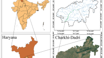
This work was carried out for the determination of the water quality in the Talagang District of Pakistan, as water is essential for agriculture and drinking uses. This study aims to assess the water quality for irrigation, drinking, and health risks using the Water Quality Index (WQI) and Human Health Risk Assessment (HHRA) tools to identify regions with contaminated water, and to evaluate the associated risks. A total of 98 water samples were taken at various points from diverse sources such as hand pumps, streams, springs, dug wells, and tube wells for physio-chemical assessment. In the current study, the effectiveness of the irrigation water quality index (IWQI), human health risk assessment (HHRA), and water quality index (WQI) tools have been assessed. The characteristics of subterranean water are influenced by evaporation, ion exchange, rock-water interaction, and parent-rock weathering, as shown by the Piper and Gibbs diagram. According to the WQI results, the water quality is 20. 89% and 27.46% of the sample sites are moderate and poor, making them unfit for human intake. Based on HHRA, compared to adult males and females in the study area, children are deemed to be at a higher risk. A larger number of the sample localities are appropriate for irrigation purposes. The study assists in identifying contaminated regions and in monitoring newly implemented remediation actions to manage the source of contaminants in the study area.
Surface and subterranean water are essential sources of drinking, farming, industrial, and domestic uses worldwide and also have a substantial effect on shaping the quality of lives and sustainability of societies1. Due to rapid growth and population increase, natural and human actions such as industry, urbanization, mining, and agriculture have resulted in water depletion and impairment issues2,3. Water quality degradation and depletion have emerged as significant global challenges, directly impacting public health, agriculture, and the environment4,5. The poor quality of water poses both direct and indirect health risks to the communities that rely on it, often leading to substantial public health issues and increased costs for water treatment and rehabilitation6. Direct health risks are associated with the consumption of contaminated water, such as heavy metal contamination, which can cause serious illnesses7,8. Indirect health risks occur when contaminated water is used for irrigation, affecting agricultural crops, horticulture, and aquaculture, leading to bioaccumulation of toxins in the food chain9.Heavy metals including Zn, Cu, and Mn are naturally occurring in water in trace amounts and are significantly essential for human metabolism and the growth of living things10. However, excessive amounts of these metals pose chronic and acute health issues. Other heavy metals including Pb, Cd, As, Cr, and Ni are severely toxic although in very low concentrations11. For example, the higher concentration of Pb is known to harm the development of the brain in children. Exposure to elevated concentrations of Cd causes chronic and acute diseases such as skeletal and kidney damage. The As causes many health problems in humans such as skin lesions, and cancer of the liver, brain, stomach, and kidney12,13. Higher intakes of Cr and Ni have been linked with liver, kidney, and heart problems14. The WQI is a handy means for evaluating the quality of water that is appropriate for residential practice. The weighted arithmetic and integrated WQI are extensively used in India for assessing surface and subterranean water because it yield results with greater accuracy1516. investigatedthe chemistry and quality index of groundwater in northwest China and noticed that 11.43% of sample locations had poor water quality, and 17.14% had very poor water quality. Similarly17, used weighted overlay analysis to assess groundwater quality for drinking and irrigation purposes in Bangladesh, revealing that 90% of water from deep wells and 57.6% from shallow wells were suitable for human consumption, according to the Drinking Water Quality Index (DWQI).
Several recent studies have employed various techniques to assess water quality, including the use of WQI, which integrates multiple physicochemical variables into a single dimensionless value representing overall water quality18,19,20,21,22. The WQI is an assessment model that can be used for integrating a variety of physicochemical variables into a dimensionless value that may depict the overall quality of the water18,20. n Pakistan, water quality contamination has been reported in several regions, affecting both surface and groundwater resources11. Given the importance of water for human health, agriculture, and overall well-being, it is crucial to evaluate the water quality in various regions. The primary objective of this study is to assess the surface and subsurface water quality for irrigation, drinking, and health risks in Talagang District, Pakistan, using the Water Quality Index (WQI) and Human Health Risk Assessment (HHRA) tools. This research aims to evaluate the hydro-chemical parameters of groundwater in the study area for both irrigation and drinking purposes, and to assess the associated health risks using the WQI and HHRA models. The findings will contribute to identifying areas where water quality poses health risks and help in formulating strategies for water management and remediation.
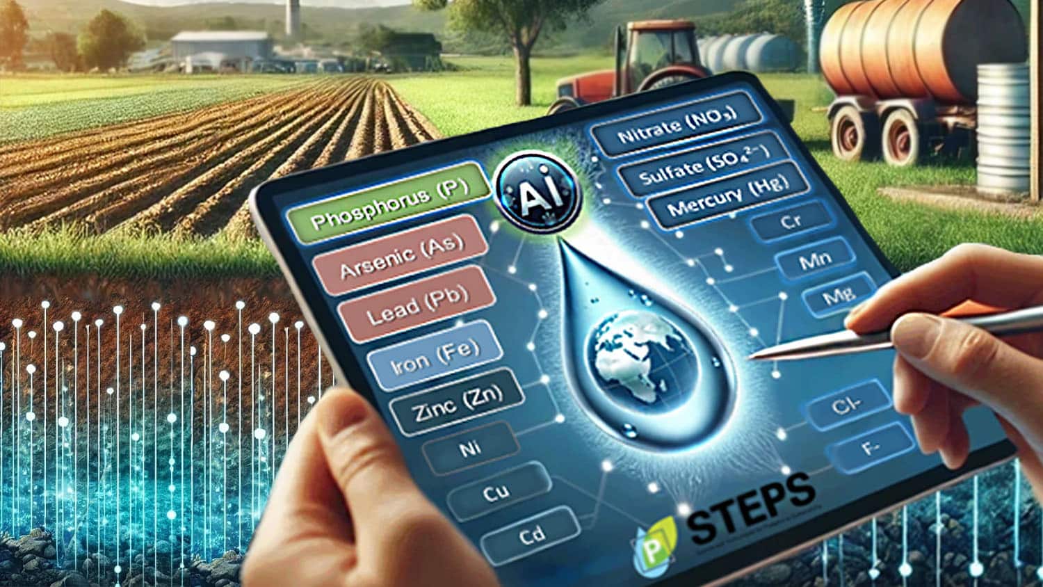
An interdisciplinary team of researchers has developed a machine learning framework that uses limited water quality samples to predict which inorganic pollutants are likely to be present in a groundwater supply. The new tool allows regulators and public health authorities to prioritize specific aquifers for water quality testing.
This proof-of-concept work focused on Arizona and North Carolina but could be applied to fill critical gaps in groundwater quality in any region.
Groundwater is a source of drinking water for millions and often contains pollutants that pose health risks. However, many regions lack complete groundwater quality datasets.
“Monitoring water quality is time-consuming and expensive, and the more pollutants you test for, the more time-consuming and expensive it is,” says Yaroslava Yingling, co-corresponding author of a paper describing the work and Kobe Steel Distinguished Professor of Materials Science and Engineering at North Carolina State University.
“As a result, there is interest in identifying which groundwater supplies should be prioritized for testing, maximizing limited monitoring resources,” Yingling says. “We know that naturally occurring pollutants, such as arsenic or lead, tend to occur in conjunction with other specific elements due to geological and environmental factors. This posed an important data question: with limited water quality data for a groundwater supply, could we predict the presence and concentrations of other pollutants?”
“Along with identifying elements that pose a risk to human health, we also wanted to see if we could predict the presence of other elements – such as phosphorus – which can be beneficial in agricultural contexts but may pose environmental risks in other settings,” says Alexey Gulyuk, a co-first author of the paper and a teaching professor of materials science and engineering at NC State.
To address this challenge, the researchers drew on a huge data set, encompassing more than 140 years of water quality monitoring data for groundwater in the states of North Carolina and Arizona. Altogether, the data set included more than 20 million data points, covering more than 50 water quality parameters.
“We used this data set to ‘train’ a machine learning model to predict which elements would be present based on the available water quality data,” says Akhlak Ul Mahmood, co-first author of this work and a former Ph.D. student at NC State. “In other words, if we only have data on a handful of parameters, the program could still predict which inorganic pollutants were likely to be in the water, as well as how abundant those pollutants are likely to be.”
One key finding of the study is that the model suggests pollutants are exceeding drinking water standards in more groundwater sources than previously documented. While actual data from the field indicated that 75-80% of sampled locations were within safe limits, the machine learning framework predicts that only 15% to 55% of the sites may truly be risk-free.
“As a result, we’ve identified quite a few groundwater sites that should be prioritized for additional testing,” says Minhazul Islam, co-first author of the paper and a Ph.D. student at Arizona State University. “By identifying potential ‘hot spots,’ state agencies and municipalities can strategically allocate resources to high-risk areas, ensuring more targeted sampling and effective water treatment solutions”
“It’s extremely promising and we think it works well,” Gulyuk says. “However, the real test will be when we begin using the model in the real world and seeing if the prediction accuracy holds up.”
Moving forward, researchers plan to enhance the model by expanding its training data across diverse U.S. regions; integrating new data sources, such as environmental data layers, to address emerging contaminants; and conducting real-world testing to ensure robust, targeted groundwater safety measures worldwide.
“We see tremendous potential in this approach,” says Paul Westerhoff, co-corresponding author and Regents’ Professor in the School of Sustainable Engineering and the Built Environment at ASU. “By continuously improving its accuracy and expanding its reach, we’re laying the groundwork for proactive water safety measures across the globe.”
“This model also offers a promising tool for tracking phosphorus levels in groundwater, helping us identify and address potential contamination risks more efficiently,” says Jacob Jones, director of the National Science Foundation-funded Science and Technologies for Phosphorus Sustainability (STEPS) Center at NC State, which helped fund this work. “Looking ahead, extending this model to support broader phosphorus sustainability could have a significant impact, enabling us to manage this critical nutrient across various ecosystems and agricultural systems, ultimately fostering more sustainable practices.”
The paper, “Multiple Data Imputation Methods Advance Risk Analysis and Treatability of Co-occurring Inorganic Chemicals in Groundwater,” is published open access in the journal Environmental Science & Technology. The paper was co-authored by Emily Briese and Mohit Malu, both Ph.D. students at Arizona State; Carmen Velasco, a former postdoctoral researcher at Arizona State; Naushita Sharma, a postdoctoral researcher at Oak Ridge National Laboratory; and Andreas Spanias, a professor of digital signal processing at Arizona State.
This work was supported by the NSF STEPS Center; and by the Metals and Metal Mixtures: Cognitive Aging, Remediation and Exposure Sources (MEMCARE) Superfund Research Center based at Harvard University, which is supported by the National Institute of Environmental Health Science under grant P42ES030990.
-shipman-
Note to Editors: The study abstract follows.
“Multiple Data Imputation Methods Advance Risk Analysis and Treatability of Co-occurring Inorganic Chemicals in Groundwater”
Authors: Akhlak U. Mahmood, Alexey V. Gulyuk and Yaroslava G. Yingling, North Carolina State University; Minhazul Islam, Emily Briese, Carmen A. Velasco, Mohit Malu, Naushita Sharma, Andreas Spanias and Paul Westerhoff, Arizona State University
Abstract: Accurately assessing and managing risks associated with inorganic pollutants in groundwater is imperative. Historic water quality databases are often sparse due to rationale or financial budgets for sample collection and analysis, posing challenges in evaluating exposure or water treatment effectiveness. We utilized and compared two advanced multiple data imputation techniques, AMELIA and MICE algorithms, to fill gaps in sparse groundwater quality data sets. AMELIA outperformed MICE in handling missing values, as MICE tended to overestimate certain values, resulting in more outliers. Field data sets revealed that 75% to 80% of samples exhibited no co-occurring regulated pollutants surpassing MCL values, whereas imputed values showed only 15% to 55% of the samples posed no health risks. Imputed data unveiled a significant increase, ranging from 2 to 5 times, in the number of sampling locations predicted to potentially exceed health-based limits and identified samples where 2 to 6 co-occurring chemicals may occur and surpass health-based levels. Linking imputed data to sampling locations can pinpoint potential hotspots of elevated chemical levels and guide optimal resource allocation for additional field sampling and chemical analysis. With this approach, further analysis of complete data sets allows state agencies authorized to conduct groundwater monitoring, often with limited financial resources, to prioritize sampling locations and chemicals to be tested. Given existing data and time constraints, it is crucial to identify the most strategic use of the available resources to address data gaps effectively. This work establishes a framework to enhance the beneficial impact of funding groundwater data collection by reducing uncertainty in prioritizing future sampling locations and chemical analyses.
Summary:Converting forest land to urban development or agricultural use can present risks to water quality when done near streams or river sources. This study examined data from 15 water treatment plants in the Middle Chattahoochee watershed to model the impacts of four potential land use scenarios several decades into the future.Share:
FULL STORY
A new study from North Carolina State University researchers finds that conversion of forests to urban development or agriculture near streams can have harmful effects on water quality downstream, presenting both health concerns and raising the cost of water treatment.
Using a model called the Soil and Water Assessment Tool, researchers mapped out the current and projected future effects of four land-use scenarios at 15 water intake locations across the Middle Chattahoochee watershed in Georgia and Alabama. By combining a series of potential socioeconomic outcomes and climate change models reaching out to 2070, researchers examined several potential land use change scenarios to predict their effects on water quality.
Katherine Martin, associate professor in the NC State University College of Natural Resources and co-author of a paper on the study, said that in models where forest cover was converted to other land uses, water quality suffered.
“In terms of aspects of water quality that we have long term data on, two of the biggest are nitrogen levels and the amount of sediment in the water. Looking at those two, in places where we’re losing forest cover, we see both of those increasing,” she said. “Those are both detrimental to the quality of drinking water, and they require more filtration.”
Part of the issue, Martin said, is the relatively high level of fertilizer used in large-scale agriculture. Urban development results in large areas of impermeable surfaces, where rainwater cannot soak into the ground and instead runs off into rivers and streams. This causes the water to carry more sediment into those waterways than it would if it had been absorbed into the ground.
Increased filtration has several knock-on effects, Martin said. Not only is it potentially harmful for aquatic life, but it also increases the cost of managing water treatment plants. For facilities that do not serve large populations, this can lead to large per-capita price increases that end up being passed on to residents. These areas are also more likely to see increased development, due to their abundance of open land. The study suggests that more attention should be paid to where development might have serious effects on water quality for people living nearby, Martin said.
“Agriculture and urban development are beneficial, and this study does not say otherwise,” she said. “What we are seeing is that there are tradeoffs when we lose forest cover, and we need to open up the conversation about those.”
This work was supported by the U.S. Department of Agriculture Forest Service Southern Research Station agreement number 20-CS-11330180-053.
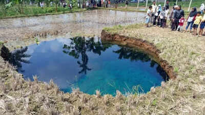
Villagers drank sinkhole water as a ‘miracle cure’, until officials found dangerous bacteria
TOI World Desk / TIMESOFINDIA.COM / Jan 19, 2026, 04:24 IST
Residents in West Sumatra, Indonesia have been urged to stop collecting and drinking water from a newly formed sinkhole after authorities found it was contaminated with E. coli, a bacteria linked to serious gastrointestinal illness.The incident unfolded in Limapuluh Kota Regency, where a large ground collapse drew crowds of locals who believed the water pooling inside the sinkhole had medicinal properties. Videos and posts showing people lining up with bottles quickly spread online, turning the site into an unlikely “healing water” destination.That belief, officials say, is not just unproven. It could be dangerous.
Authorities warn water is unsafe
West Sumatra’s Deputy Governor Vasko Ruseimy publicly cautioned residents not to consume the water after tests showed it contained Escherichia coli (E. coli). Reports citing early findings from the Geological Agency and local health checks said the water did not meet safe drinking standards, and officials warned against using it for “health” or “treatment” claims.E. coli contamination is often considered a red-flag indicator because it can suggest the presence of harmful pathogens introduced through surface runoff, soil contamination, or waste intrusion.
Where the sinkhole appeared
The sinkhole reportedly opened in a rice field area in Jorong Tepi, Nagari Situjuah Batua, part of Limapuluh Kota Regency. Indonesian authorities and geology experts began assessing the site soon after it was reported, as concern grew about whether the collapse could expand.A geology expert from Universitas Gadjah Mada (UGM) said the phenomenon was shaped by local geological conditions and was likely triggered by heavy rainfall, linking it to wider hydrometeorological impacts felt across parts of Sumatra.
Why sinkholes happen in the first place
Sinkholes form when the ground surface collapses into an underground gap. In many cases, that gap grows silently over time, then fails suddenly.Experts say several factors can cause this:1) Hidden erosion beneath the surfaceWater moving underground can gradually carry away soil particles in a process sometimes described as “piping erosion”, eventually creating a hollow space large enough for the ground above to give way.2) Intense rainfall and flooding pressureHeavy rain can destabilise soil layers, accelerate erosion, and raise groundwater pressure. Even if the ground has been weakening for months or years, extreme rainfall can be the final trigger.3) Landscape vulnerabilitySome areas are naturally more prone to collapses depending on soil composition, underground drainage patterns, and whether the land has been altered by farming, construction, or shifting water channels.In practical terms, sinkholes are not just dramatic “holes in the ground”. They are often a sign that the underground structure has changed, and that nearby land may still be unstable.
Why drinking sinkhole water can be risky even if it looks clear
One reason the West Sumatra case drew alarm is how quickly “clean-looking” water was assumed to be safe.But sinkholes can act like natural funnels, pulling in contaminants from surrounding areas, including:
animal waste from nearby fields
bacteria from soil and surface runoff
agricultural contamination
drainage seepage
Even if the water appears clear, it may still carry harmful organisms. That’s why officials moved quickly to warn residents once E. coli was detected.
A public health warning wrapped inside a viral moment
The sinkhole water episode has become a reminder of how fast health misinformation can spread when fear, curiosity, and hope collide. For some residents, the attraction was not spectacle but belief: that unusual natural phenomena can offer cures.Authorities, however, have taken a firm line. Their message is simple: do not drink it.As officials monitor the site for further ground movement, the bigger risk may no longer be the sinkhole itself, but what happens when viral belief outruns basic water safety.
The world has entered an era of “global water bankruptcy” that is harming billions of people, a UN report has declared.
The overuse and pollution of water must be tackled urgently, the report’s lead author said, because no one knew when the whole system could collapse, with implications for peace and social cohesion.
All life depends on water but the report found many societies had long been using water faster than it could be replenished annually in rivers and soils, as well as over-exploiting or destroying long-term stores of water in aquifers and wetlands.
This had led to water bankruptcy, the report said, with many human water systems past the point at which they could be restored to former levels. The climate crisis was exacerbating the problem by melting glaciers, which store water, and causing whiplashes between extremely dry and wet weather.
Prof Kaveh Madani, who led the report, said while not every basin and country was water bankrupt, the world was interconnected by trade and migration, and enough critical systems had crossed this threshold to fundamentally alter global water risk.
The result was a world in which 75% of people lived in countries classified as water-insecure or critically water-insecure and 2 billion people lived on ground that is sinking as groundwater aquifers collapse.
Conflicts over water had risen sharply since 2010, the report said, while major rivers, such as the Colorado, in the US, and the Murray-Darling system, in Australia, were failing to reach the sea, and “day zero” emergencies – when cities run out of water, such as in Chennai, India – were escalating. Half of the world’s large lakes had shrunk since the early 1990s, the report noted. Even damp nations, such as the UK, were at risk because of reliance on imports of water-dependent food and other products.
“This report tells an uncomfortable truth: many critical water systems are already bankrupt,” said Madani, of the UN University’s Institute for Water, Environment and Health. “It’s extremely urgent [because] no one knows exactly when the whole system would collapse.”
About 70% of fresh water taken by human withdrawals was used for agriculture, but Madani said: “Millions of farmers are trying to grow more food from shrinking, polluted or disappearing water sources. Water bankruptcy in India or Pakistan, for example, also means an impact on rice exports to a lot of places around the world.” More than half of global food was grown in areas where water storage was declining or unstable, the report said.
Madani said action to deal with water bankruptcy offered a chance to bring countries together in an increasingly fragmented world. “Water is a strategic, untapped opportunity to the world to create unity within and between nations. It is one of the very rare topics that left and right and north and south all agree on its importance.”https://interactive.guim.co.uk/datawrapper/embed/rksLJ/1/?dark=false
The UN report, which is based on a forthcoming paper in the peer-reviewed journal Water Resources Management, sets out how population growth, urbanisation and economic growth have increased water demand for agriculture, industry, energy and cities. “These pressures have produced a global pattern that is now unmistakable,” it said.
In some of the world’s most densely populated river basins, including the Indus, Yellow, and Tigris-Euphrates, the rivers were periodically drying up before reaching the ocean. “In many basins, the ‘normal’ to which crisis managers once hoped to return has effectively vanished,” the report said. Lakes were also shrinking, from Lake Urmia, in Iran, to the Salton Sea, in the US, and Lake Chad. Wildlife suffered as well as people, as humans “steal” water from nature, Madani said
The over-exploitation of groundwater was causing cities to subside around the world, with Rafsanjan, in Iran, sinking by 30cm a year; Tulare, in the US, by about 28cm a year, and Mexico City by about 21cm a year. Jakarta, Manila, Lagos and Kabul were other major cities affected. Among the most visible signs of this water bankruptcy, the report said, were the 700 sinkholes peppering the heavily farmed Konya plain in Turkey.
Cities, such as Tehran, Cape Town, São Paulo and Chennai, had all faced day zero water crises, the report noted, while the number of water-related conflicts around the world had risen from 20 in 2010 to more than 400 in 2024.skip past newsletter promotion
Humanity was also slashing the amount of water available by destroying natural stores, such as wetlands, and polluting waterways. Wetlands equal in size to the entire European Union had been erased in the past five decades, the report said.
The report calls for a fundamental reset of how water is protected and used around the world. This would include cutting the rights and claims to withdraw water to match today’s degraded supply, and transforming water-intensive sectors, such as agriculture and industry, via changes in crops, more efficient irrigation and less wasteful urban systems. The report emphasises support for communities whose livelihoods must change.
“Water bankruptcy management requires honesty, courage and political will,” said Madani. “We cannot rebuild vanished glaciers or reinflate acutely compacted aquifers. But we can prevent further losses, and redesign institutions to live within new hydrological limits.”
Tshilidzi Marwala, UN undersecretary general, said: “Water bankruptcy is becoming a driver of fragility, displacement and conflict. Managing it fairly is now central to maintaining peace, stability and social cohesion.”
The challenge of sustainable water management around the world was very real, said Prof Albert Van Dijk, at the Australian National University who was not part of the UN report, although, he added, he preferred the description of collapse, or systemic failure, over bankruptcy.
A recent water report led by Van Dijk highlighted the increasingly erratic climate. “Increased variability is as much a problem as scarcity,” he said. “Sometimes there’s more water available overall, but it increasingly arrives in bursts, at the wrong place and at the wrong time. This makes management genuinely harder. For example, dam reservoir levels need to be kept low to mitigate floods but high to ensure supply during droughts.”
Dr Jonathan Paul, at Royal Holloway, University of London, said: “The report lays bare humankind’s mistreatment of water [which] threatens the viability of ‘the water cycle’ as a concept.
“The elephant in the room, which is mentioned explicitly only once, is the role of massive and unequal population growth in driving so many of the manifestations of water bankruptcy,” he said. “Addressing this growth would be more useful than tinkering with outdated, non-inclusive, and top-down water resource management frameworks.”
image: Cover of the Global Water Bankruptcy Report (UNU)view more Credit: UNU-INWEH and Pyae Phyo Aung
UN Headquarters, New York – Amid chronic groundwater depletion, water overallocation, land and soil degradation, deforestation, and pollution, all compounded by global heating, a UN report today declared the dawn of an era of global water bankruptcy, inviting world leaders to facilitate “honest, science-based adaptation to a new reality.”
“Global Water Bankruptcy: Living Beyond Our Hydrological Means in the Post-Crisis Era,” argues that the familiar terms “water stressed” and “water crisis” fail to reflect today’s reality in many places: a post-crisis condition marked by irreversible losses of natural water capital and an inability to bounce back to historic baselines.
“This report tells an uncomfortable truth: many regions are living beyond their hydrological means, and many critical water systems are already bankrupt,” says lead author Kaveh Madani, Director of the UN University’s Institute for Water, Environment and Health (UNU-INWEH), known as ‘The UN’s Think Tank on Water.’
Expressed in financial terms, the report says many societies have not only overspent their annual renewable water “income” from rivers, soils, and snowpack, they have depleted long-term “savings” in aquifers, glaciers, wetlands, and other natural reservoirs.
This has resulted in a growing list of compacted aquifers, subsided land in deltas and coastal cities, vanished lakes and wetlands, and irreversibly lost biodiversity.
The UNU report is based on a peer-reviewed paper in the journal of Water Resources Management that formally defines water bankruptcy as
1) persistent over-withdrawal from surface and groundwater relative to renewable inflows and safe levels of depletion; and
2) the resulting irreversible or prohibitively costly loss of water-related natural capital.
By contrast:
“Water stress” reflects high pressure that remains reversible
“Water crisis” describes acute shocks that can be overcome
The report is issued prior to a high-level meeting in Dakar, Senegal (26–27 Jan.) to prepare the 2026 UN Water Conference, to be co-hosted by the United Arab Emirates and Senegal 2-4 Dec. in the UAE.
While not every basin and country is water-bankrupt, Madani says, “enough critical systems around the world have crossed these thresholds. These systems are interconnected through trade, migration, climate feedbacks, and geopolitical dependencies, so the global risk landscape is now fundamentally altered.”
Madani underlines the following four essential points:
Water cannot be protected if we allow the hydrological cycle, the climate, and the underlying natural capital that produces water to be interrupted or damaged. The world has an important and still largely untapped strategic opportunity to act.
Water is an issue that crosses traditional political boundaries. It belongs to north and south, and to left and right. For that reason, it can serve as a bridge to create trust and unity between and within nations. In the fragmented world we live in, water can become a powerful focus for cooperation and for aligning national security with international priorities.
Investment in water is also investment in mitigating climate change, biodiversity loss, and desertification. Water should not be treated only as a downstream sector affected by other environmental crises. On the contrary, targeted investment in water can address the immediate concerns of communities and nations while also advancing the objectives of the Rio Conventions (climate, biodiversity, desertification).
A renewed global emphasis on water could help reaccelerate stalled negotiations and potentially reenergize halted international processes. A practical and cooperative focus on water offers a way to connect urgent local needs with long-term global goals.
Hotspots
In the Middle East and North Africa region, high water stress, climate vulnerability, low agricultural productivity, energy-intensive desalination, and sand and dust storms intersect with complex political economies;
In parts of South Asia, groundwater-dependent agriculture and urbanization have produced chronic declines in water tables and local subsidence; and
In the American Southwest, the Colorado River and its reservoirs have become symbols of over-promised water.
A world in the red
Drawing on global datasets and recent scientific evidence, the report presents a stark statistical overview of trends, the overwhelming majority caused by humans:
50%: Large lakes worldwide that have lost water since the early 1990s (with 25% of humanity directly dependent on those lakes)
50%: Global domestic water now derived from groundwater
40%+: Irrigation water drawn from aquifers being steadily drained
70%: Major aquifers showing long-term decline
410 million hectares: Area ofnatural wetlands – almost equal in size to the entire European Union – erased in the past five decades
30%+: Global glacier mass lost since 1970, with entire low- and mid-latitude mountain ranges expected to lose functional glaciers altogether within decades
Dozens: Major rivers that now fail to reach the sea for parts of the year
50+ years: How long many river basins and aquifers have been overdrawing their accounts
100 million hectares: Cropland damaged by salinization alone
And the human consequences:
75%: Humanity in countries classified as water-insecure or critically water-insecure
2 billion: People living on sinking ground.
25 cm: Annual drop being experienced by some cities
4 billion: People facing severe water scarcity at least one month every year
170 million hectares: Irrigated cropland under high or very high water stress – equivalent to the areas of France, Spain, Germany, and Italy combined
US$5.1 trillion: Annual value of lost wetland ecosystem services
3 billion: People living in areas where total water storage is declining or unstable, with 50%+ of global food produced in those same stressed regions.
1.8 billion: People living under drought conditions in 2022–2023
US$307 billion: Current annual global cost of drought
2.2 billion: People who lack safely managed drinking water, while 3.5 billion lack safely managed sanitation
Says Madani: “Millions of farmers are trying to grow more food from shrinking, polluted, or disappearing water sources. Without rapid transitions toward water-smart agriculture, water bankruptcy will spread rapidly.”
A new diagnosis for a new era
A region can be flooded one year and still be water bankrupt, he adds, if long-term withdrawals exceed replenishment. In that sense, water bankruptcy is not about how wet or dry a place looks, but about balance, accounting, and sustainability.
Says Madani: As with global climate change or pandemics, a declaration of global water bankruptcy does not imply uniform impact everywhere, but that enough systems across regions and income levels have become insolvent and crossed irreversible thresholds to constitute a planetary-scale condition.
“Water bankruptcy is also global because its consequences travel,” Madani explains. “Agriculture accounts for the vast majority of freshwater use, and food systems are tightly interconnected through trade and prices. When water scarcity undermines farming in one region, the effects ripple through global markets, political stability, and food security elsewhere. This makes water bankruptcy not a series of isolated local crises, but a shared global risk that demands a new type of response: Bankruptcy management, not crisis management.”
A call to reset the global water agenda
The report warns that the current global water agenda – largely focused on drinking water, sanitation, and incremental efficiency improvements – is no longer fit for purpose in many places and calls for a new global water agenda that:
Formally recognizes the state of water bankruptcy
Recognizes water as both a constraint and an opportunity for meeting climate, biodiversity, and land commitments
Elevates water issues in climate, biodiversity, and desertification negotiations, development finance, and peacebuilding processes.
Embeds water-bankruptcy monitoring in global frameworks, using Earth observation, AI, and integrated modelling
Uses water as a catalyst to accelerate cooperation between the UN Member States
In practical terms, managing water bankruptcy requires governments to focus on the following priorities:
Prevent further irreversible damage such as wetland loss, destructive groundwater depletion, and uncontrolled pollution
Rebalance rights, claims, and expectations to match degraded carrying capacity
Support just transitions for communities whose livelihoods must change
Transform water-intensive sectors, including agriculture and industry, through crop shifts, irrigation reforms, and more efficient urban systems
Build institutions for continuous adaptation, with monitoring systems linked to threshold-based management
The report underlines that water bankruptcy is not merely a hydrological problem, but a justice issue with deep social and political implications requiring attention at the highest levels of government and multilateral cooperation. The burdens fall disproportionately on smallholder farmers, Indigenous Peoples, low-income urban residents, women and youth while the benefits of overuse often accrued to more powerful actors.
“Water bankruptcy is becoming a driver of fragility, displacement, and conflict,” says UN Under-Secretary-General Tshilidzi Marwala, Rector of UNU. “Managing it fairly – ensuring that vulnerable communities are protected and that unavoidable losses are shared equitably – is now central to maintaining peace, stability, and social cohesion.”
“Bankruptcy management requires honesty, courage, and political will,” Madani adds. “We cannot rebuild vanished glaciers or reinflate acutely compacted aquifers. But we can prevent further loss of our remaining natural capital, and redesign institutions to live within new hydrological limits.”
Upcoming milestones — the 2026 and 2028 UN Water Conferences, the end of the Water Action Decade in 2028, and the 2030 SDG deadline, for example — provide critical opportunities to implement this shift, he says.
“Despite its warnings, the report is not a statement of hopelessness,” adds Madani. “It is a call for honesty, realism, and transformation. Declaring bankruptcy is not about giving up — it is about starting fresh. By acknowledging the reality of water bankruptcy, we can finally make the hard choices that will protect people, economies, and ecosystems. The longer we delay, the deeper the deficit grows.”
* * * * *
Report in brief
Media highlights
This report declares that the world has already entered the era of Global Water Bankruptcy. The condition is not a distant threat but a present reality. Many human water systems are now in a post-crisis failure state where past baselines can no longer be restored.
Global Water Bankruptcy is defined as a persistent post-crisis state of failure. In this state, long-term water use and pollution have exceeded renewable inflows and safe depletion limits. Key parts of the water system can no longer realistically be brought back to previous levels of supply and ecosystem function.
Terms such as water stress and water crisis are no longer sufficient descriptions of the world’s new water realities. Many rivers, lakes, aquifers, wetlands, and glaciers have been pushed beyond tipping points and cannot bounce back to past baselines. The language of temporary crisis is no longer accurate in many regions.
The global water cycle has moved beyond its safe planetary boundary. Together with climate, biodiversity, and land systems, freshwater has been pushed outside its safe operating space. The report concludes that the world is living beyond its hydrological means.
Billions of people are living with chronic water insecurity. Around 2.2 billion people still lack safely managed drinking water, 3.5 billion lack safely managed sanitation, and nearly 4 billion face severe water scarcity for at least one month each year. Almost three-quarters of the world’s population live in countries classified as water insecure or critically water insecure.
Surface waters and wetlands are shrinking on a massive scale. More than half of the world’s large lakes have lost water since the early 1990s, affecting about one-quarter of the global population that relies on them directly. Over the last five decades, humanity has lost roughly 410 million hectares of natural wetlands, almost the land area of the European Union. This includes about 177 million hectares of inland marshes and swamps, roughly the size of Libya or seven times the area of the United Kingdom. The loss of ecosystem services from these wetlands is valued at over US$5.1 trillion, similar to the combined GDP of around 135 of the world’s poorest countries.
Groundwater depletion and land subsidence show that hidden reserves are being exhausted. Around 70 percent of the world’s major aquifers show long-term declines. Land subsidence linked to groundwater over-pumping now affects more than 6 million square kilometers, almost 5 percent of the global land area, and nearly 2 billion people. This permanently reduces storage and increases flood risk in many cities, deltas, and coastal zones.
Water quality degradation further reduces usable water and accelerates bankruptcy. Growing loads of untreated wastewater, agricultural runoff, industrial pollution, and salinization are degrading rivers, lakes, and aquifers. Even where volumes appear sufficient on paper, the fraction of water that is safe for drinking, irrigation, and ecosystems continues to shrink.
The cryosphere is melting, eroding a critical long-term water buffer. The world has already lost more than 30 percent of its glacier mass since 1970. Some mountain ranges risk losing functional glaciers within decades, undermining water security for hundreds of millions of people who depend on rivers fed by glacier and snowmelt.
Farmers and food systems sit at the very heart of Global Water Bankruptcy. Roughly 70 percent of global freshwater withdrawals are used for agriculture, much of it in the Global South. Groundwater provides about 50 percent of domestic water use and over 40 percent of irrigation water worldwide. Both drinking water and food production now depend heavily on aquifers that are being depleted faster than they can realistically recharge.
Global food production is increasingly exposed to water decline and degradation. About 3 billion people and more than half of global food production are concentrated in areas where total water storage is already declining or unstable. More than 170 million hectares of irrigated cropland, about the combined land area of France, Spain, Germany, and Italy, are under high or very high water stress. Salinization has degraded roughly 82 million hectares of rainfed cropland and 24 million hectares of irrigated cropland, eroding yields in key global breadbaskets.
Drought impacts are becoming steadily more human-made and extremely costly. The report identifies a growing pattern of anthropogenic drought, meaning water deficits caused by overuse and degradation rather than natural variability alone. These impacts already cost around US$307 billion per year, more than the annual GDP of almost three-quarters of United Nations Member States.
Global Water Bankruptcy is also a justice, security, and political economy challenge. Without a deliberate commitment to equity, the costs of adjustment will fall disproportionately on farmers, rural communities, Indigenous Peoples, informal urban residents, women, youth, and other vulnerable groups. This imbalance increases the risk of social unrest and conflict in many regions.
Governments need to urgently shift from crisis management to bankruptcy management. The report calls for an end to short-term emergency thinking. Instead, it urges strategies that prevent further irreversible damage, reduce and reallocate demand, transform water-intensive sectors, tackle illegal withdrawals and pollution, and ensure just transitions for people whose livelihoods must change.
The current global water agenda is no longer fit for the Anthropocene. A narrow focus on drinking water, sanitation, and small efficiency gains will not be sufficient to resolve escalating water risks. In fact, that limited approach will increasingly compromise progress on climate action, biodiversity protection, land management, food security, and peace.
Water can be a bridge in a fragmented world. Every country, sector, and community depends on freshwater. Investing in water bankruptcy management therefore becomes an investment in climate stability, biodiversity protection, land restoration, food security, employment, and social harmony. This shared reliance offers practical common ground for cooperation between North and South and across political divides within nations.
World leaders are urged to use upcoming UN water milestones as decisive turning points. The report calls on governments and the UN system to use the 2026 and 2028 UN Water Conferences, the conclusion of the Water Action Decade in 2028, and the 2030 Sustainable Development Goal deadline to reset the global water agenda. It urges formal recognition of Global Water Bankruptcy, stronger monitoring and diagnostics, and a renewed effort to position water as a bridge for peace, climate action, biodiversity protection, and food security in an increasingly fragmented world.
******
Key Policy Messages
The world is already in the state of “water bankruptcy”. In many basins and aquifers, long-term overuse and degradation mean that past hydrological and ecological baselines cannot realistically be restored. While not every basin or country is water-bankrupt, enough critical systems around the world have crossed these thresholds, and are interconnected through trade, migration, climate feedbacks, and geopolitical dependencies, that the global risk landscape is now fundamentally altered.
The familiar language of “water stress” and “water crisis” is no longer adequate. Stress describes high pressure that is still reversible. Crisis describes acute, time-bound shocks. Water bankruptcy must be recognized as a distinct post-crisis state, where accumulated damage and overshoot have undermined the system’s capacity to recover.
Water bankruptcy management must address insolvency and irreversibility. Unlike financial bankruptcy management, which deals only with insolvency, managing water bankruptcy is concerned with rebalancing demand and supply under conditions where returning to baseline conditions is no longer possible.
Anthropogenic drought is central to the world’s new water reality. Drought and water shortage are increasingly driven by human activities, over-allocation, groundwater depletion, land and soil degradation, deforestation, pollution, and climate change, rather than natural variability alone. Water bankruptcy is the outcome of long-term anthropogenic drought, not just bad luck with hydrological anomalies.
Water bankruptcy is about both quantity and quality. Declining stocks, polluted rivers, and degrading aquifers, and salinized soils mean that the truly usable fraction of available water is shrinking, even where total volumes may appear stable.
Managing water bankruptcy requires a shift from crisis management to bankruptcy management. The priority is no longer to “get back to normal”, but to prevent further irreversible damage, rebalance rights and claims within degraded carrying capacities, transform water-intensive sectors and development models, and support just transitions for those most affected.
Governance institutions must protect both water and its underlying natural capital. The existing institutions focus on protecting water as a good or service disregarding the natural capital that makes water available in the first place. Efforts to protect a product are ineffective when the processes that produce it are disrupted. Recognizing water bankruptcy calls for developing legal and governance institutions that can effectively protect not only water but also the hydrological cycle and natural capital that make its production possible.
Water bankruptcy is a justice and security issue. The costs of overshoot and irreversibility fall disproportionately on smallholder farmers, rural and Indigenous communities, informal urban residents, women, youth, and downstream users, while benefits have often accrued to more powerful actors. How societies manage water bankruptcy will shape social cohesion, political stability, and peace.
Water bankruptcy management combines mitigation with adaptation. While water crisis management paradigms seek to return the system to normal conditions through mitigation efforts only, water bankruptcy management focuses on restoring what is possible and preventing further damages through mitigation combined with adaptation to new normals and constraints.
Water can serve as a bridge in a fragmented world. Water can align national priorities with international priorities and improve cooperation between and within nations. Roughly 70% of global freshwater withdrawals are used for agriculture, much of it by farmers in the Global South. Elevating water in global policy debates can help rebuild trust between South and North but also within nations, between rural and urban, left and right constituencies.
Water must be recognized as an upstream sector. Most national and international policy agendas treat water as a downstream impact sector where investments are focused on mitigating the imposed problems and externalities. The world must recognize water as an upstream opportunity sector where investments have long-term benefits for peace, stability, security, equity, economy, health, and the environment.
Water is an effective medium to fulfill the global environmental agenda. Investments in addressing water bankruptcy deliver major co-benefits for the global efforts to address its environmental problems while addressing the national security concerns of the UN member states. Elevating water in the global policy agenda can renew international cooperation, increase the efficiency of environmental investments, and reaccelerate the halted progress of the three Rio Conventions to address climate change, biodiversity loss, and desertification.
A new global water agenda is urgently needed. Existing agendas and conventional water policies, focused mainly on WASH, incremental efficiency gains and generic IWRM guidelines, are not sufficient for the world’s current water reality. A fresh water agenda must be developed that takes Global Water Bankruptcy as a starting point and uses the 2026 and 2028 UN Water Conferences, the conclusion of the Water Action Decade in 2028, and the 2030 SDG 6 timeline as milestones for resetting how the world understands and governs water.
* * * * *
Report Information
Global Water Bankruptcy: Living Beyond Our Hydrological Means in the Post-Crisis Era, United Nations University Institute for Water, Environment and Health (UNU-INWEH), Richmond Hill, Ontario, Canada, doi: 10.53328/INR26KAM001
Support Paper
Madani K. (2026) Water Bankruptcy: The Formal Definition, Water Resources Management.
About UNU-INWEH
The United Nations University Institute for Water, Environment and Health (UNU-INWEH) is one of 13 institutions that make up the United Nations University (UNU), the academic arm of the UN. Known as ‘The UN’s Think Tank on Water’, UNU-INWEH addresses critical water, environmental, and health challenges around the world. Through research, training, capacity development, and knowledge dissemination, the institute contributes to solving pressing global sustainability and human security issues of concern to the UN and its Member States.
Headquartered in Richmond Hill, Ontario, UNU-INWEH has been hosted and supported by the Government of Canada since 1996. With a global mandate and extensive partnerships across UN entities, international organizations, and governments, UNU-INWEH operates through its UNU Hubs in Calgary, Hamburg, New York, Lund, and Pretoria, and an international network of affiliates.
A new report on the economic importance of a strong water sector forecasts that America will need to invest $3.4 trillion over the next 20 years to modernize its infrastructure.
As Iran’s water crisis continues, dams in the country’s second-largest city, Mashhad, have dwindled to less than 3 percent capacity.
Millions of people in Niger, Nigeria, and Ghana are at high risk of surface water contamination and loss as a result of deforestation, a new report indicates.
The over-extraction of sand from Cambodia’s Tonle Sap, Asia’s largest lake and a crucial Mekong River source, threatens to shrink its wet-season size by up to 40 percent.
The Lead
For every 1,000 hectares of forest cleared in Niger and Nigeria, almost 10 hectares of surface water disappear, according to a study released this month from Water Aid and Tree Aid, two international NGOs.
The links between deforestation and worsening water crises in West Africa are clear, the report shows. Across Ghana, Niger, and Nigeria, 122 million people live in areas of high surface water risk as a direct result of deforestation — a 5 million-person increase in five years. Nigeria alone, which loses 27,000 hectares of vegetation cover annually, accounts for 70 percent of this vulnerable population.
In Niger, the impacts of deforestation are particularly dire. Tree loss imperils nearly all the country’s available freshwater sources. In the primarily arid and semi-arid country, climate change is giving rise to a pronounced “more drought, more flood” phenomenon. Without forests to filter and absorb excess water, storms – when they do arrive – are falling increasingly in extreme bursts, resulting in runoff, contamination, and infrastructure damage. But there is also hope. Of the three countries studied, Niger is the only one to achieve a net gain in forest cover since 2013, adding more than 100,000 hectares.
When invested into water infrastructure in America, it yields $2.5 million in economic output, according to a report released last week by the nonprofit U.S. Water Alliance. What’s more, that $1 million provides 10 jobs, $837,000 in labor income, and $1.4 million in GDP.
The publication, a centerpiece of the organization’s Value of Water campaign, links the country’s financial health with sound water investments — a relationship that is strained by widespread underinvestment, it warns. Over the next 20 years, the report estimates that America will need to spend roughly $3.4 trillion to modernize and repair its aging wastewater, treatment, and stormwater facilities. The problem is comparatively worse in rural communities, which face greater needs per-capita than urban areas in 80 percent of states.
Per capita, these investments would have the greatest impact in North Dakota, Iowa, Louisiana, West Virginia, Vermont, and New Hampshire.
“Clean water utilities are on the frontlines of protecting public health and the environment. This report affirms what we have long known — that closing the investment gap will not only safeguard clean water, but also strengthen the entire U.S. economy,” Adam Krantz, CEO of the National Association of Clean Water Agencies, said in the report.
Amount by which the wet season-size of Tonle Sap, the largest lake in Asia, will shrink by 2038 if local mining continues at its current pace, according to a study published this week in the journal Nature Sustainability. A rising demand for sand, used to make concrete and glass, has led to increased dredging in the Cambodian lake, which drains for half of the year into the Mekong River, supporting its southern flow. But during the rainy summer months of May through October, rising water levels in the Mekong reverse this trend, and Tonle Sap pulses, “expanding the lake’s surface area by 4 to 6 times and swelling its water volume to 80 cubic kilometers,” Science reports. This dynamic supports some of the world’s most biodiverse riparian, lake, and wetland habitat, and the livelihoods and cultural identities of some 60 million people who live along the Mekong’s shores. In the absence of strong, nutrient-rich pulses, fisheries and water supplies are at risk of collapse.
According to Science, sand is the world’s second most-exploited resource, “often extracted from riverbeds or shores.” Water is the most exploited. Both Cambodia and Vietnam have banned sand export, though its mining from the Mekong watershed continues, to the detriment of its health and local human communities, flora, and fauna.
As the Tehran metropolitan area — home to nearly 18 million people — nears a potential Day Zero scenario within two weeks, Iran’s second-largest city is also facing acute water shortages amid widespread drought, exacerbated by mismanagement.
The water levels in dams in Mashhad, population 4 million, have dwindled to less than 3 percent capacity, Agence France-Presse (AFP) reports. The city’s water consumption has been measured at roughly 8,000 liters per second, “of which about 1,000 to 1,500 litres per second is supplied from the dams,” Hossein Esmaeilian, the chief executive of Mashhad’s water company, told AFP. Residents are urged to reduce their water consumption by 20 percent, he said.
Tehran officials admitted this week that water rationing began too late in the capital, a failure that may now lead to forced evacuations, according to Iran International. The country’s central plateau may be depopulated as a result of “a chronic disconnect between scientists, industry, and government agencies.” Already, residents of villages and rural regions have abandoned their land amid shortages and migrated toward city centers, further straining limited reservoir supplies.
Wetland Watch
MARSH Project: Near the historic downtown of Charleston, South Carolina, a grassroots effort to preserve important salt marshes along the Ashley River — installed amid rollbacks to the Clean Water Act — has proved successful in mitigating floods, the Associated Press reports.
Calving icebergs unleash hidden wave forces that supercharge Greenland’s melt and push the ice sheet closer to collapse.
Source:University of ZurichSummary:Researchers in Greenland used a 10-kilometer fiber-optic cable to track how iceberg calving stirs up warm seawater. The resulting surface tsunamis and massive hidden underwater waves intensify melting at the glacier face. This powerful mixing effect accelerates ice loss far more than previously understood. The work highlights how fragile the Greenland ice system has become as temperatures rise.Share:
FULL STORY
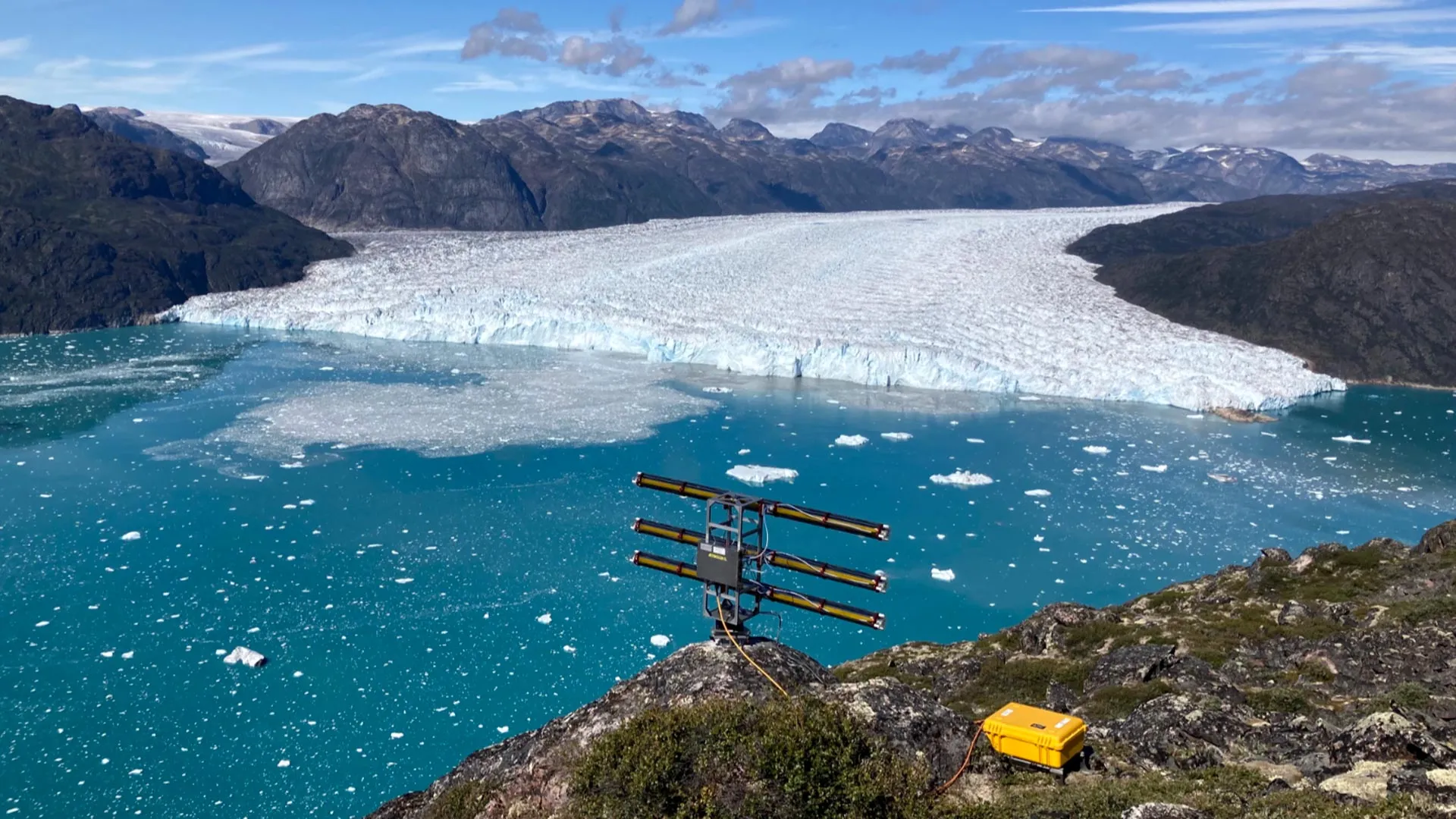
View of the fjord and the three-kilometer-wide calving front of Eqalorutsit Kangilliit Sermiat in southern Greenland. The fiber-optic cable was laid a few hundred meters from the ice wall through the 300-meter-deep water on the seabed. In the foreground is the UZH radar device, which measures calving events and ice movements in order to interpret the data from the fiber-optic cable. Credit: Andreas Vieli, University of Zurich
Iceberg calving happens when large pieces of ice split from the front of a glacier and fall into the ocean. This natural event is a major contributor to the rapid reduction of ice on the Greenland ice sheet. For the first time, an international team led by the University of Zurich (UZH) and the University of Washington (UW) has used fiber-optic technology to track how the impact of falling ice, along with the movement of the released ice, causes glacial meltwater to mix with warmer seawater below the surface.
“The warmer water increases seawater-induced melt erosion and eats away at the base of the vertical wall of ice at the glacier’s edge. This, in turn, amplifies glacier calving and the associated mass loss from ice sheets,” explains Andreas Vieli, a professor in UZH’s Department of Geography and co-author of the research. Vieli leads the Cryosphere cluster, one of six groups in the international GreenFjord project in southern Greenland, supported by the Swiss Polar Institute. The team’s discovery about how ice and seawater interact was highlighted on the cover of Nature.
Wave measurements using fiber-optic cable on seafloor
During the GreenFjord project, researchers from UZH, UW and several Swiss partners carried out an extensive field campaign to study calving behavior. They placed a ten-kilometer-long fiber-optic cable on the seafloor across the fjord in front of the Eqalorutsit Kangilliit Sermiat glacier. This fast-moving glacier in southern Greenland releases about 3.6 km3 of ice into the ocean each year, which is almost three times the annual volume of the Rhône glacier near the Furka mountain pass in Switzerland.
The research team relied on Distributed Acoustic Sensing (DAS), a method that detects tiny vibrations along the cable caused by events such as newly formed crevasses, falling ice blocks, ocean waves or temperature changes. “This enables us to measure the many different types of waves that are generated after icebergs break off,” says lead author Dominik Gräff, a UW postdoctoral researcher affiliated with ETH Zurich.
Underwater waves amplify glacier melt and erosion
After an iceberg crashes into the water, surface waves called calving-induced tsunamis sweep across the fjord and mix the upper water layers. Because seawater in Greenland’s fjords is warmer and denser than meltwater, it sinks toward the deeper layers.
The team also detected another type of wave that continues to move between density layers long after the surface becomes calm. These internal underwater waves, which can reach heights comparable to skyscrapers, cannot be seen from above but keep mixing the water for extended periods. This ongoing movement brings warm water upward, increasing melting and erosion at the glacier’s edge and promoting further calving. “The fiber-optic cable allowed us to measure this incredible calving multiplier effect, which wasn’t possible before,” says Gräff. The data gathered will support future efforts to document calving events and better understand the rapid decline of ice sheets.
A fragile and threatened system
Scientists have long known that interactions between seawater and calving play an important role in glacier retreat, but collecting detailed measurements in the field has been extremely difficult. Fjords filled with icebergs present constant hazards from falling ice, and satellite observations cannot capture what happens below the surface where these interactions occur. “Our previous measurements have often merely scratched the surface, so a new approach was needed,” says Andreas Vieli.
The Greenland ice sheet covers an area around 40 times larger than Switzerland. If it were to melt completely, global sea levels would rise by about seven meters. The large volumes of meltwater flowing from shrinking glaciers can also disrupt major ocean currents such as the Gulf Stream, with significant consequences for Europe’s climate. The retreat of calving glaciers further affects the ecosystems within Greenland’s fjords. “Our entire Earth system depends, at least in part, on these ice sheets. It’s a fragile system that could collapse if temperatures rise too high,” warns Dominik Gräff.
New research challenges long-held ideas about how volcanic islands form and how Earth’s interior stays dynamic.
Source:University of Southampton
Summary:Researchers discovered that continents don’t just split at the surface—they also peel from below, feeding volcanic activity in the oceans. Simulations reveal that slow mantle waves strip continental roots and push them deep into the oceanic mantle. Data from the Indian Ocean confirms this hidden recycling process, which can last tens of millions of years.Share:
FULL STORY
Continents slowly peel away from below, sending slivers deep into the oceanic mantle that fuel volcanic activity far from tectonic edges. This newfound process, traced through the Indian Ocean, reshapes how scientists understand Earth’s hidden geological engine. Credit: Shutterstock
Earth scientists have uncovered a slow and surprising process beneath our planet’s surface that helps fuel volcanic activity in the oceans.
Researchers from the University of Southampton found that fragments of continents are gradually stripped away from below and drawn into the oceanic mantle — the hot, mostly solid layer beneath the sea floor that slowly circulates. Once there, this continental material can power volcanic eruptions for tens of millions of years.
This discovery resolves a long-standing geological puzzle: why certain ocean islands located far from tectonic plate boundaries contain chemical signatures that look distinctly continental, even though they lie in the middle of vast oceans.
The study, published in Nature Geoscience, was conducted by an international team from the University of Southampton, GFZ Helmholtz Centre for Geosciences in Potsdam, the University of Potsdam, Queen’s University (Canada), and Swansea University.
Ancient chemical clues deep within the mantle
Ocean islands such as Christmas Island in the northeast Indian Ocean often contain unusually high concentrations of certain “enriched” elements that typically come from continents. Scientists have compared this mixing process to the motion of a cake mixer folding in older, recycled ingredients from deep within the Earth.
For years, geologists assumed these enriched elements came from ocean sediments pulled into the mantle when tectonic plates sink, or from columns of rising hot rock known as mantle plumes.
However, those explanations have limits. Some volcanic regions lack evidence of recycled crust, while others seem too shallow and cool to be driven by deep mantle plumes.
“We’ve known for decades that parts of the mantle beneath the oceans look strangely contaminated, as if pieces of ancient continents somehow ended up in there,” said Thomas Gernon, Professor of Earth Science at the University of Southampton and the study’s lead author. “But we haven’t been able to adequately explain how all that continental material got there.”
Continents are peeling from below
The researchers propose a new mechanism: continents not only split apart at the surface but also peel away from below, and across far greater distances than scientists once believed possible.
To test this, the team built computer simulations that recreated how the mantle and continental crust behave when stretched by tectonic forces.
Their results show that when continents begin to break apart, powerful stresses deep within the Earth trigger a slow-moving “mantle wave.” This rolling motion travels along the base of the continents at depths of 150 to 200 kilometers, disturbing and gradually stripping material from their deep roots.
The process happens at an incredibly slow rate — roughly a millionth the speed of a snail. Over time, these detached fragments are carried sideways for more than 1,000 kilometers into the oceanic mantle, where they feed volcanic activity for tens of millions of years.
Study co-author Professor Sascha Brune of GFZ in Potsdam explained, “We found that the mantle is still feeling the effects of continental breakup long after the continents themselves have separated. The system doesn’t switch off when a new ocean basin forms — the mantle keeps moving, reorganizing, and transporting enriched material far from where it originated.”
Clues from the Indian Ocean
To support their model, the team analyzed chemical and geological data from regions such as the Indian Ocean Seamount Province — a chain of volcanic formations that appeared after the breakup of the supercontinent Gondwana over 100 million years ago.
Their findings show that soon after Gondwana split apart, a pulse of magma unusually rich in continental material erupted to the surface. Over time, this chemical signature gradually faded as the flow of material from beneath the continents diminished. Notably, this happened without the presence of a deep mantle plume, challenging long-held assumptions about the source of such volcanism.
Professor Gernon added: “We’re not ruling out mantle plumes, but this discovery points to a completely new mechanism that also shapes the composition of the Earth’s mantle. Mantle waves can carry blobs of continental material far into the oceanic mantle, leaving behind a chemical signature that endures long after the continents have broken apart.”
The research also builds on the team’s earlier work showing that these slow, rolling mantle waves can have dramatic effects deep inside continents. Their previous studies suggest that such waves may help trigger diamond eruptions and even reshape landscapes thousands of kilometers away from tectonic boundaries.
New research reveals that deep-sea mining waste could disrupt one of Earth’s most vital but least understood ecosystems.
Source:University of Hawaii at Manoa
Summary:Scientists have discovered that deep-sea mining plumes can strip vital nutrition from the ocean’s twilight zone, replacing natural food with nutrient-poor sediment. The resulting “junk food” effect could starve life across entire marine ecosystems.Share:
FULL STORY
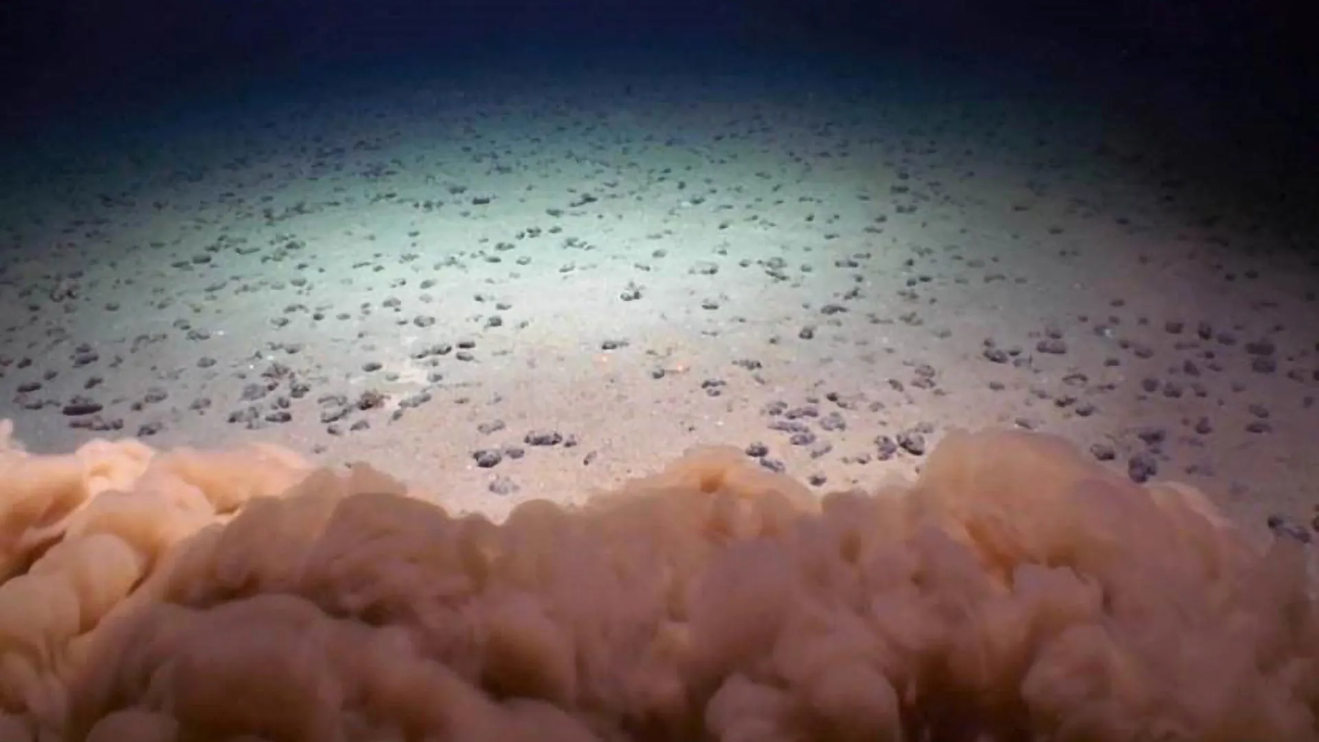
Nodules on the abyssal seafloor in the Clarion Clipperton Zone with a mud cloud from a scientific remotely-operated vehicle (ROV) touching down. Credit: UH/NOAA DeepCCZ Expedition
A new study from the University of Hawai’i (UH) at Mānoa, published on November 6 in Nature Communications, provides the first direct evidence that waste from deep-sea mining could disrupt vital ecosystems in the Pacific Ocean’s Clarion-Clipperton Zone (CCZ). This area, one of the most biologically rich regions of the deep sea, is now the focus of growing industrial interest. Researchers found that sediment discharged during mining operations could harm marine life in the midwater “twilight zone,” a key habitat between 200 and 1,500 meters below the surface that supports vast populations of tiny drifting animals called zooplankton — the foundation of the ocean’s food web.
The team determined that 53% of zooplankton and 60% of micronekton, which feed on zooplankton, would be affected by mining waste discharge. Such disturbances could ripple through the food chain, ultimately impacting larger predators such as fish, seabirds, and marine mammals.
Murky Plumes and “Junk Food” Sediment
“When the waste released by mining activity enters the ocean, it creates water as murky as the mud-filled Mississippi River. The pervasive particles dilute the nutritious, natural food particles usually consumed by tiny, drifting Zooplankton,” said Michael Dowd, lead author of the study and a graduate student in Oceanography at the UH Mānoa School of Ocean and Earth Science and Technology (SOEST).
“Micronekton, small shrimp, fish and other animals that swim, feed on zooplankton. Some migrate between the depths and near surface waters and they are consumed by fish, seabirds and marine mammals. Zooplankton’s exposure to junk food sediment has the potential to disrupt the entire food web.”
Measuring the Nutritional Impact of Deep-Sea Mining
The research, titled “Deep-sea mining discharge can disrupt midwater food webs,” examined the effects of sediment plumes released during a 2022 mining test in the CCZ. This vast region is targeted for the extraction of polymetallic nodules that contain valuable minerals such as cobalt, nickel, and copper — key components for electric vehicles and renewable technologies.
By collecting and analyzing water samples from the depths where waste was discharged, the scientists found that mining particles contained far fewer amino acids, an important measure of nutritional quality, than the natural particles that typically nourish marine organisms.
“This isn’t just about mining the seafloor; it’s about reducing the food for entire communities in the deep sea,” said co-author Erica Goetze, a SOEST oceanography professor and marine zooplankton specialist. “We found that many animals at the depth of discharge depend on naturally occurring small detrital particles — the very food that mining plume particles replace.”
At present, around 1.5 million square kilometers of the CCZ are licensed for deep-sea mining exploration, reflecting the surge in global demand for minerals used in low-carbon technologies.
Disrupting an Ecosystem Built on Scarcity
During the mining process, nodules are collected from the seafloor along with surrounding sediments and seawater, then pumped to a surface vessel where nodules are separated from the waste material. The leftover sediment and fine nodule fragments are then released back into the ocean. Some companies have proposed releasing this waste within the twilight zone, but the environmental consequences of such practices have remained largely unknown — until now.
These findings underscore a major regulatory gap, as no international rules currently govern where or how mining waste can be discharged.
The twilight zone teems with life, including krill, squid, fish, octopus, and delicate jelly-like species. Many of these organisms travel upward toward the surface each night to feed and then descend again by day, transporting carbon to the deep ocean in the process. This vertical migration helps maintain the planet’s carbon balance and supports the health of marine ecosystems worldwide.
“Our research suggests that mining plumes don’t just create cloudy water — they change the quality of what’s available to eat, especially for animals that can’t easily swim away,” said co-author Jeffrey Drazen, a deep-sea ecologist and SOEST professor of oceanography. “It’s like dumping empty calories into a system that’s been running on a finely tuned diet for hundreds of years.”
Global Implications for Marine Food Webs
The study raises concerns that large-scale mining could trigger widespread and long-lasting changes in ocean ecosystems if it proceeds without strict safeguards. Even commercial fisheries could be affected; for instance, tuna populations migrate through the CCZ, meaning the impacts of mining could extend to seafood consumed around the world.
“Deep-sea mining has not yet begun at a commercial scale, so this is our chance to make informed decisions,” said co-author Brian Popp, SOEST professor of Earth sciences and an expert in marine stable isotope biogeochemistry. “If we don’t understand what’s at stake in the midwater, we risk harming ecosystems we’re only just beginning to study.”
A Call for Responsible Regulation
The authors hope their results will guide policy discussions currently underway at the International Seabed Authority and inform environmental reviews conducted by the National Oceanic and Atmospheric Administration. They stress the importance of developing international rules to protect marine ecosystems from surface waters to the deep sea.
“Before commercial deep-sea mining begins, it is essential to carefully consider the depth at which mining waste is discharged,” added Drazen. “The fate of these mining waste plumes and their impact on ocean ecosystems varies with depth, and improper discharge could cause harm to communities from the surface to the seafloor.”
Additional contributors to the study include UH Mānoa oceanography graduate students Victoria Assad and Alexus Cazares-Nuesser, and oceanography professor Angelicque White.