Ice doesn’t just freeze, it fuels hidden chemistry that could turn rivers rusty as the planet warms.
Source:Umea University
Summary:Researchers found that ice can trigger stronger chemical reactions than liquid water, dissolving iron minerals in extreme cold. Freeze-thaw cycles amplify the effect, releasing iron into rivers and soils. With climate change accelerating these cycles, Arctic waterways may face major transformations.
FULL STORY
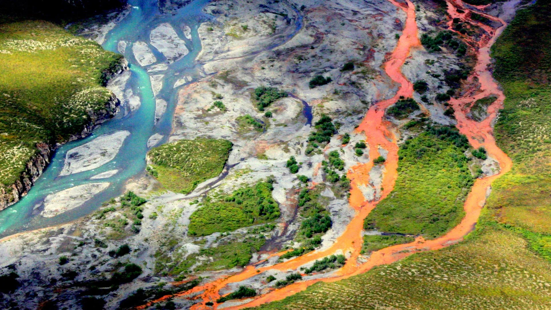
An aerial view of the rust-colored Kutuk River in Gates of the Arctic National Park in Alaska. Thawing permafrost is exposing minerals to weathering, increasing the acidity of the water, which releases metals like iron, zinc, and copper. Credit: Ken Hill / National Park Service
Ice can dissolve iron minerals more effectively than liquid water, according to a new study from Umeå University. The discovery could help explain why many Arctic rivers are now turning rusty orange as permafrost thaws in a warming climate.
The study, recently published in the scientific journal PNAS, shows that ice at minus ten degrees Celsius releases more iron from common minerals than liquid water at four degrees Celsius. This challenges the long-held belief that frozen environments slow down chemical reactions.
“It may sound counterintuitive, but ice is not a passive frozen block,” says Jean-François Boily, Professor at Umeå University and co-author of the study. “Freezing creates microscopic pockets of liquid water between ice crystals. These act like chemical reactors, where compounds become concentrated and extremely acidic. This means they can react with iron minerals even at temperatures as low as minus 30 degrees Celsius.”
To understand the process, the researchers studied goethite – a widespread iron oxide mineral – together with a naturally occurring organic acid, using advanced microscopy and experiments.
They discovered that repeated freeze-thaw cycles make iron dissolve more efficiently. As the ice freezes and thaws, organic compounds that were previously trapped in the ice are released, fuelling further chemical reactions. Salinity also plays a crucial role: fresh and brackish water increase dissolution, while seawater can suppress it.
The findings apply mainly to acidic environments, such as mine drainage sites, frozen dust in the atmosphere, acid sulfate soils along the Baltic Sea coast, or in any acidic frozen environment where iron minerals interact with organics. The next step is to find out if the same is true for all iron-bearing ice. This is what ongoing research in the Boily laboratory will soon reveal.
“As the climate warms, freeze-thaw cycles become more frequent,” says Angelo Pio Sebaaly, doctoral student and first author of the study. “Each cycle releases iron from soils and permafrost into the water. This can affect water quality and aquatic ecosystems across vast areas.”
The findings show that ice is not a passive storage medium, but an active player. As freezing and thawing increase in polar and mountain regions, for the impact on ecosystems. and the natural cycling of elements could be significant.
Summary:A global research effort offers the first worldwide view of how climate change could affect water availability and drought severity in the decades to come. By the late 21st century, global land area and population facing extreme droughts could more than double — increasing from 3% during 1976-2005 to 7%-8%, according to a professor of civil and environmental engineering.Share:
FULL STORY
Michigan State University is leading a global research effort to offer the first worldwide view of how climate change could affect water availability and drought severity in the decades to come.
By the late 21st century, global land area and population facing extreme droughts could more than double — increasing from 3% during 1976-2005 to 7%-8%, according to Yadu Pokhrel, associate professor of civil and environmental engineering in MSU’s College of Engineering, and lead author of the research published in Nature Climate Change.
“More and more people will suffer from extreme droughts if a medium-to-high level of global warming continues and water management is maintained at its present state,” Pokhrel said. “Areas of the Southern Hemisphere, where water scarcity is already a problem, will be disproportionately affected. We predict this increase in water scarcity will affect food security and escalate human migration and conflict.”
The research team, including MSU postdoctoral researcher Farshid Felfelani, and more than 20 contributing authors from Europe, China and Japan are projecting a large reduction in natural land water storage in two-thirds of the world, also caused by climate change.
Land water storage, technically known as terrestrial water storage, or TWS, is the accumulation of water in snow and ice, rivers, lakes and reservoirs, wetlands, soil and groundwater — all critical components of the world’s water and energy supply. TWS modulates the flow of water within the hydrological cycle and determines water availability as well as drought.
“Our findings are a concern,” Pokhrel said. “To date, no study has examined how climate change would impact land water storage globally. Our study presents the first, comprehensive picture of how global warming and socioeconomic changes will affect land water storage and what that will mean for droughts until the end of the century.”
Felfelani said the study has given the international team an important prediction opportunity.
“Recent advances in process-based hydrological modeling, combined with future projections from global climate models under wide-ranging scenarios of socioeconomic change, provided a unique foundation for comprehensive analysis of future water availability and droughts,” Felfelani said. “We have high confidence in our results because we use dozens of models and they agree on the projected changes.”
The research is based on a set of 27 global climate-hydrological model simulations spanning 125 years and was conducted under a global modeling project called the Inter-Sectoral Impact Model Intercomparison Project. Pokhrel is a working member of the project.
“Our findings highlight why we need climate change mitigation to avoid the adverse impacts on global water supplies and increased droughts we know about now,” Pokhrel said. “We need to commit to improved water resource management and adaptation to avoid potentially catastrophic socio-economic consequences of water shortages around the world.”
Melting glaciers are putting a hold on countries’ development
Source:Ohio State University
Summary:Climate change is putting an enormous strain on global water resources, and according to researchers, the Tibetan Plateau is suffering from a water imbalance so extreme that it could lead to an increase in international conflicts.Share:
FULL STORY
Climate change is putting an enormous strain on global water resources, and according to researchers, the Tibetan Plateau is suffering from a water imbalance so extreme that it could lead to an increase in international conflicts.
Nicknamed “The Third Pole,” the Tibetan Plateau and neighboring Himalayas is home to the largest global store of frozen water outside of the North and South Polar Regions. This region, also known as the Asian water tower (AWT), functions as a complex water distribution system which delivers life-giving liquid to multiple countries, including parts of China, India, Nepal, Pakistan, Afghanistan, Tajikistan and Kyrgyzstan.
Yet due to the rapid melting of snow and upstream glaciers, the area can’t sustainably support the continued growth of the developing nations that rely on it.
“Populations are growing so rapidly, and so is the water demand,” said Lonnie Thompson, distinguished university professor of earth sciences at The Ohio State University and senior research scientist at the Byrd Polar Research Center. “These problems can lead to increased risks of international and even intranational disputes, and in the past, they have.”
Thompson, who has studied climate change for nearly five decades, is intimately familiar with the precarious nature of the region’s hydrological situation. In 1984, Thompson became a member of the first Western team sent to investigate the glaciers in China and Tibet. Since then, he and a team of international colleagues have spent years investigating ice core-derived climate records and the area’s rapidly receding ice along with the impact it’s had on the local settlements that depend on the AWT for their freshwater needs.
The team’s latest paper, of which Thompson is a co-author, was published in the journal Nature Reviews Earth and Environment. Using temperature change data from 1980 to 2018 to track regional warming, their findings revealed that the AWT’s overall temperature has increased at about 0.42 degrees Celsius per decade, about twice the global average rate.
“This has huge implications for the glaciers, particularly those in the Himalayas,” Thompson said. “Overall, we’re losing water off the plateau, about 50% more water than we’re gaining.” This scarcity is causing an alarming water imbalance: Northern parts of Tibet often experience an overabundance of water resources as more precipitation occurs due to the strengthening westerlies, while southern river basins and water supplies shrink as drought and rising temperatures contribute to water loss downstream.
According to the study, because many vulnerable societies border these downstream basins, this worsening disparity could heighten conflicts or exacerbate already tense situations between countries that share these river basins, like the long-term irrigation and water struggles between India and Pakistan.
“The way that regional climate varies, there are winners and losers,” Thompson said. “But we have to learn to work together in order to ensure adequate and equitable water supplies throughout this region.” As local temperatures continue to rise and water resources become depleted, more people will end up facing ever diminishing water supplies, he said.
Still, overall increases in precipitation alone won’t meet the increased water demands of downstream regions and countries.
To combat this, the study recommends using more comprehensive water monitoring systems in data-scarce areas, noting that better atmospheric and hydrologic models are needed to help predict what’s happening to the region’s water supply. Lawmakers should then use those observations to help develop actionable policies for sustainable water management, Thompson said. If policymakers do decide to listen to the scientists’ counsel, these new policies could be used to develop adaptation measures for the AWT through collaboration between upstream and downstream countries.
After all, when things go awry in one area of the world, like the butterfly effect, they tend to have long-lasting effects on the rest of Earth’s population. “Climate change is a global process,” Thompson said. “It doesn’t matter what country or what part of the world you come from. Sooner or later, you’ll have a similar problem.”
Exposure to oil — and possibly the chemicals used to clean up oil spills — has made corals prone to breaking and showing signs of high stress, even today
Source:American Geophysical Union
Summary:Deep-water corals in the Gulf of Mexico are still struggling to recover from the devastating Deepwater Horizon oil spill in 2010, scientists report at the Ocean Science Meeting in New Orleans. Comparing images of more than 300 corals over 13 years — the longest time series of deep-sea corals to date — reveals that in some areas, coral health continues to decline to this day.Share:
FULL STORY
Deep-water corals in the Gulf of Mexico are still struggling to recover from the devastating Deepwater Horizon oil spill in 2010, scientists report at the Ocean Sciences Meeting in New Orleans. Comparing images of more than 300 corals over 13 years — the longest time series of deep-sea corals to date — reveals that in some areas, coral health continues to decline to this day.
The spill slathered hundreds of miles of shoreline in oil, and a slick the size of Virginia coated the ocean surface. Over 87 days, 134 million gallons of oil spilled directly from the wellhead at a depth of 1520 meters (nearly 5000 feet) into the Gulf. While the spill was most visible at the surface, negative ecological impacts extended hundreds of meters into the ocean.
In a presentation on Tuesday, 20 February, scientists will show that deep-water corals remain damaged long after the spill. Over 13 years, these coral communities have had limited recovery — some even continuing to decline.
“We always knew that deep-sea organisms take a long time to recover, but this study really shows it,” said Fanny Girard, a marine biologist and conservationist at the University of Hawai’i at Mānoa who led the work. “Although in some cases coral health appeared to have improved, it was shocking to see that the most heavily impacted individuals are still struggling, and even deteriorating, a decade later.”
The findings can help guide deep-water restoration efforts following oil spills.
Delicate and damaged
A few months after the Deepwater Horizon well was capped, an interdisciplinary team of researchers surveyed the ocean floor 6 to 22 kilometers (3.7 to 13.7 miles) from the wellhead to record the damage. About 7 miles away and at 1,370 meters (4,495 feet) depth, they found a dense forest of tree-like Paramuricea corals that looked sickly.
“These corals were covered in a brown material,” Girard said. Testing showed the sludge contained traces of a combination of oil and chemical dispersants. A few months later, the researchers found two additional coral sites at 1,580 meters and 1,875 meters (4921 and 6233 feet, respectively) deep that were similarly damaged.
Deep-sea corals are suspension feeders and may have ingested contaminated particles, leading to the observed health impacts, the researchers said. Direct exposure to toxic chemicals contained in the mixture of oil and chemicals may have also damaged coral tissue. However, to date, scientists still do not exactly know how the oil and dispersant affected these vulnerable organisms.
Every year from 2010 to 2017, scientists visited those three sites to monitor damages, measure growth rates and note any recovery of the corals, as part of a large initiative aiming to better understand ecosystem impacts and improve our ability to respond to future oil spills. They used a remotely operated vehicle to take high-resolution photographs of corals at all three impacted sites and two far-removed reference sites, tracking more than 300 corals overall.
The researchers visited these sites again in 2022 and 2023 as part of the Habitat Assessment and Evaluation project, one of the projects funded through the Natural Resource Damage Assessment settlement. The images allowed the team to measure changes to coral health over time, including noting any breaks along the delicate branches of the coral caused by exposure to oil pollution.
Still suffering after all these years
The scientists found that even by 2022, the affected corals continued to show signs of stress and damage from the oil spill. The brown coating they had first observed was long gone, but upon closer inspection, the corals were weak and prone to breaking. The scarred spots where branches fell off were leaking mucus, and some corals whose skeletons were exposed had been colonized by other, parasitic coral species.
“Not only were some of these corals not recovering, but some of them seemed to be getting worse,” Girard said. She added that if the impacts are too heavy, ecosystems can struggle to recover at all, especially given the onslaught of climate change-related stressors like ocean acidification. “It’s really important to prevent damage in the first place, and the way to do that is through protection measures.”
Girard notes that their work is being used to inform restoration strategies, including trying to grow deep-sea corals for coral propagation from transplants, deploying artificial anchoring sites for recolonization or protecting the deepwater communities and letting nature heal itself. In the coming years, the team will continue to monitor to corals, looking for signs that they’re getting better — or worse.
Summary:The Dead Sea isn’t just the saltiest body of water on Earth—it’s a living laboratory for the formation of giant underground salt deposits. Researchers are unraveling how evaporation, temperature shifts, and unusual mixing patterns lead to phenomena like “salt snow,” which falls in summer as well as winter. These processes mirror what happened millions of years ago in the Mediterranean, leaving behind thick salt layers still buried today.Share:
FULL STORY
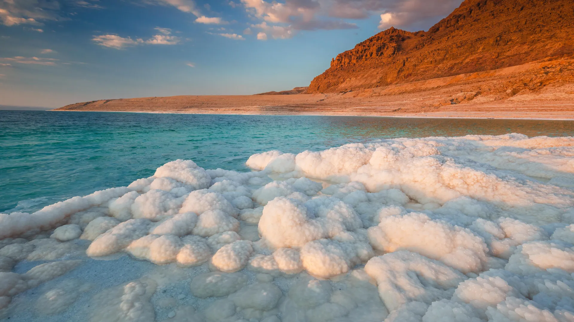
The Dead Sea’s extreme salinity and shifting water layers produce salt giants and even summer “salt snow.” Studying these rare processes provides clues to ancient oceans and modern coastal stability. Credit: Shutterstock
The Dead Sea is a confluence of extraordinary conditions: the lowest point on the Earth’s surface, with one of the world’s highest salinities. The high concentration of salt gives it a correspondingly high density, and the water body’s status as the deepest hypersaline lake gives rise to interesting and often temperature-related phenomena below the water’s surface that researchers are still uncovering.
One of the most intriguing features of the Dead Sea continues to be revealed: salt giants, large-scale salt deposits.
“These large deposits in the Earth’s crust can be many, many kilometers horizontally, and they can be more than a kilometer thick in the vertical direction,” said UC Santa Barbara mechanical engineering professor Eckart Meiburg, lead author of a paper published in the Annual Review of Fluid Mechanics. “How were they generated? The Dead Sea is really the only place in the world where we can study the mechanism of these things today.”
Indeed, while there are other bodies of water in the world with massive salt formations, such as the Mediterranean and Red seas, only in the Dead Sea can one find them in the making, which allows researchers to tackle the physical processes behind their evolution, and in particular, the spatial and temporal variations in their thickness.
Evaporation, precipitation, saturation
In their paper, Meiburg and fellow author Nadav Lensky of the Geological Survey of Israel cover the fluid dynamical and associated sediment transport processes currently governing the Dead Sea. These processes are influenced by several factors, including the Dead Sea’s status as a saltwater terminal lake — a lake with no outflow — leaving evaporation as the primary way water leaves the lake, which has been shrinking for millennia and leaving salt deposits as it does so. More recently, damming of the Jordan River, which feeds into the lake, has accelerated lake level decline, estimated at roughly 1 meter (3 feet) per year.
Temperatures along the water column also play a role in the dynamics behind salt giants and other formations such as salt domes and chimneys. A once “meromictic” (stably stratified) lake — the Dead Sea was layered such that less dense warmer water at the surface overlaid a more saline, cooler layer at depth throughout the entire year.
“It used to be such that even in the winter when things cooled off, the top layer was still less dense than the bottom layer,” Meiburg explained. “And so as a result, there was a stratification in the salt.”
That changed in the early 1980s thanks to the partial diversion of the Jordan River, which resulted in evaporation outpacing the rate of freshwater inflow. At that time, the surface salinity reached the levels found at depth, enabling mixing between the two layers and transitioning the lake from meromictic to holomictic (a lake that experiences annual overturns in the water column). The Dead Sea continues to stratify, but only for eight of the warmer months of the year.
In 2019, Meiburg et al identified a rather unique process occurring in the lake during the summer: halite crystal precipitation or “snow” that was more typical in the cooler season. Halite (“rock salt”) precipitates when the concentration of salt exceeds the amount that the water can dissolve, hence the deeper, colder, denser conditions of the bottom layer are where it is most likely to happen, and in the cooler months. However, they observed that during the summer, while evaporation was increasing the salinity of the upper layer, salts were nonetheless continuing to dissolve in that layer due to its warmer temperature. This leads to a condition called “double diffusion” at the interface between the two layers, in which sections of the saltier warmer water of the top layer cool down and sink, while portions of the lower, cooler, relatively less dense water warm up and rise. As the upper, denser layer cools down, salts precipitate out, creating the “salt snow” effect.
The combination of evaporation, temperature fluctuations and density changes throughout the water column, in addition to other factors including internal currents and surface waves, conspire to create salt deposits of various shapes and sizes, assert the authors. In contrast to shallower hypersaline bodies in which precipitation and deposition occur during the dry season, in the Dead Sea, these processes were found to be most intense during the winter months. This year-round “snow” season at depth explains the emergence of the salt giants, found in other saline bodies such as the Mediterranean Sea, which once dried up during the Messinian Salinity Crisis, about 5.96 to 5.33 million years ago.
“There was always some inflow from the North Atlantic into the Mediterranean through the Strait of Gibraltar,” Meiburg said. “But when tectonic motion closed off the Strait of Gibraltar, there couldn’t be any water inflow from the North Atlantic.” The sea level dropped 3-5 km (2-3 miles) due to evaporation, creating the same conditions currently found in the Dead Sea and leaving behind the thickest of this salt crust that can still be found buried below the deep sections of the Mediterranean, he explained. “But then a few million years later the Strait of Gibraltar opened up again, and so you had inflow coming in from the North Atlantic and the Mediterranean filled up again.”
Meanwhile, salinity fluxes and the presence of springs on the sea floor contribute to the formation of other interesting salt structures, such as salt domes and salt chimneys, according to the researchers.
In addition to gaining a fundamental understanding of some of the idiosyncratic processes that can occur in evaporating, hypersaline lakes, research into the associated sediment transport processes occurring on the emerging beaches may also yield insight on the stability and erosion of arid coastlines under sea level change, as well as the potential for resource extraction, the authors state.
First long-term study on the East Antarctic interior ice sheet region reveals the Indian Ocean mechanism driving this change
Source: Nagoya University
Summary: New research has revealed that East Antarctica’s vast and icy interior is heating up faster than its coasts, fueled by warm air carried from the Southern Indian Ocean. Using 30 years of weather station data, scientists uncovered a hidden climate driver that current models fail to capture, suggesting the world’s largest ice reservoir may be more vulnerable than previously thought. Share:
FULL STORY
Scientists discovered that East Antarctica’s interior is warming faster than its coasts due to warm air flows from the Southern Indian Ocean. Current climate models don’t capture this effect, suggesting ice loss could be underestimated. Credit: Shutterstock
Scientists have confirmed that East Antarctica’s interior is warming faster than its coastal areas and identified the cause. A 30-year study, published in Nature Communications and led by Nagoya University’s Naoyuki Kurita, has traced this warming to increased warm air flow triggered by temperature changes in the Southern Indian Ocean. Previously considered an observation “blind spot,” East Antarctica contains most of the world’s glacial ice. This newly identified warming mechanism indicates that current predictions may underestimate the rate of future Antarctic ice loss.
Collecting data in Earth’s most extreme environment
Antarctica, the world’s coldest, driest, and windiest continent, contains about 70% of Earth’s freshwater frozen in its massive ice sheets. Climate change in the region has been studied using data from manned stations located mostly in coastal areas. However, the Antarctic interior has only four manned stations, with long-term climate data available for just two: Amundsen-Scott Station (South Pole) and Vostok Station (East Antarctic Interior). Therefore, the actual state of climate change in the vast interior remained largely undocumented.
The research group collected observation data from three unmanned weather stations in East Antarctica where observations have continued since the 1990s: Dome Fuji Station, Relay Station, and Mizuho Station. They created a monthly average temperature dataset spanning 30 years, from 1993 to 2022.
Annual average temperature changes showed that all three locations experienced temperature increases at a rate of 0.45-0.72°C per decade, faster than the global average. The researchers analyzed meteorological and oceanic data and traced this temperature rise to changes in the Southern Indian Ocean that alter atmospheric circulation patterns and transport warm air toward Antarctica’s interior.
Current climate models do not capture this warming process, so future projections of temperature for Antarctica may be underestimated. “While interior regions show rapid warming, coastal stations have not yet experienced statistically significant warming trends,” Professor Naoyuki Kurita from the Institute for Space-Earth Environmental Research at Nagoya University said. “However, the intensified warm air flow over 30 years suggests that detectable warming and surface melting could reach coastal areas like Syowa Station soon.”
The Southern Indian Ocean-East Antarctica climate connection
Ocean fronts — areas where warm and cold ocean waters meet — create sharp temperature boundaries in the Southern Indian Ocean. Because global warming heats ocean waters unevenly, it intensifies these temperature differences: stronger oceanic fronts lead to more storm activity and atmospheric changes that create a “dipole” pattern, with low pressure systems in mid-latitudes and high pressure over Antarctica. The high-pressure system over Antarctica pulls warm air southward and carries it deep into the continent.
Now, for the first time, scientists have comprehensive weather station data demonstrating that East Antarctica’s interior is warming faster than its coasts and have identified the major cause of this change. The study provides important insights into how quickly the world’s largest ice reservoir will respond to continued global warming.
New study suggests that smallmouth bass and channel catfish are changing what they eat to avoid having to compete with or being eaten by the invader.
Source:Penn State
Summary: Flathead catfish are rapidly reshaping the Susquehanna River’s ecosystem. Once introduced, these voracious predators climbed to the top of the food chain, forcing native fish like channel catfish and bass to shift diets and habitats. Using stable isotope analysis, researchers uncovered how the invaders disrupt food webs, broaden dietary overlaps, and destabilize energy flow across the river system. The findings show how a single invasive species can spark cascading ecological consequences. Share:
FULL STORY
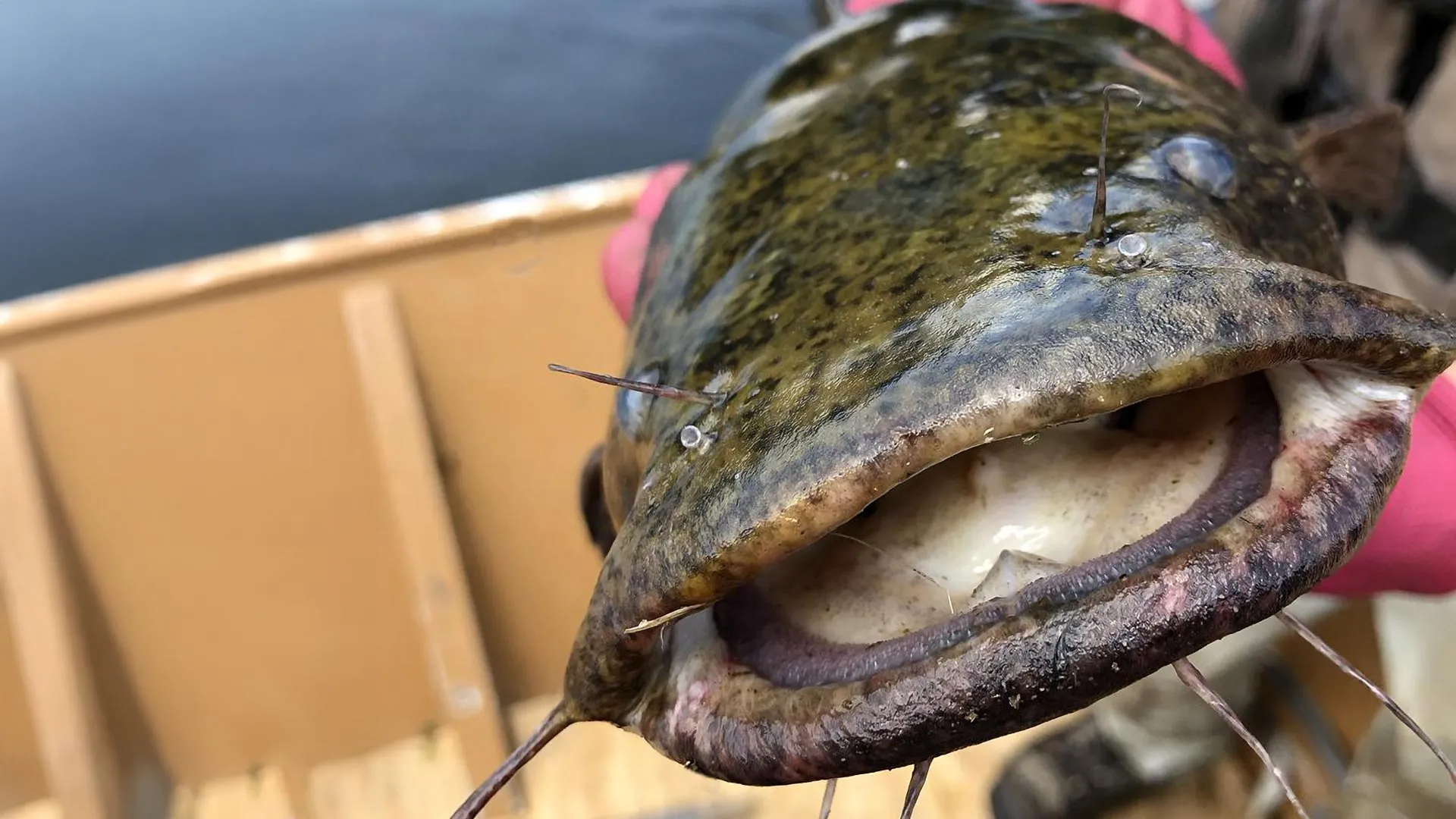
Flatheads grow fast in this river system, attain large body sizes and can eat a variety of prey. Because adult flatheads have few natural predators, they can exert strong control over the ecosystem. Credit: Penn State
Flathead catfish, opportunistic predators native to the Mississippi River basin, have the potential to decimate native and recreational fisheries, disrupting ecosystems in rivers where they become established after their introduction or invasion from a nearby river drainage. That concern led a team of researchers from Penn State, the U.S. Geological Survey (USGS), and the Pennsylvania Fish and Boat Commission to assess how flatheads are affecting the food web and energy flow in the Susquehanna River in Pennsylvania, where they were first detected in 1991. Their population has grown rapidly in the decades since.
“Flatheads grow fast in this river system, attain large body sizes and can eat a variety of prey,” said study first author Olivia Hodgson, a master’s degree student in Penn State’s Intercollege Graduate Degree Program in Ecology. “Because adult flatheads have few natural predators, flathead catfish can exert strong control over the ecosystem.”
Hodgson is working with Tyler Wagner, a scientist with the USGS Pennsylvania Cooperative Fish and Wildlife Research Unit Program and a Penn State affiliate professor of fisheries ecology. He is senior author on the study. In findings published Sept. 4 in Ecology, the researchers reported that flathead catfish are apex predators.
Flatheads had the highest trophic position — the level an organism occupies in a food web, based on its feeding relationships — even higher than resident top predators such as smallmouth bass and channel catfish. Channel catfish had a lower trophic position in areas with flathead catfish. This means they now eat lower on the food chain, likely because they are being outcompeted by flatheads or avoiding them, the researchers explained. In areas with flathead catfish, they found, all species showed broader and overlapping diets.
“This suggests that resident species are changing what they eat to avoid competing with or being eaten by the invader,” Hodgson said. “These findings support the ‘trophic disruption hypothesis,’ that says when a new predator enters an ecosystem, it forces existing species to alter their behavior, diets and roles in the food web. This can destabilize ecosystems over time. Our study highlights how an invasive species can do more than just reduce native populations — it can reshape entire foodwebs and change how energy moves through ecosystems.”
Although the predatory effects of invasive catfishes on native fish communities have been documented — such as in a recent study on the Susquehanna River led by researchers at Penn State — the impacts of invasion on riverine food webs are poorly understood, Hodgson noted. This study quantified the effects of invasive flathead catfish on the food web in the Susquehanna by comparing uninvaded river sections to invaded sections, focusing on several key species: flathead catfish — invader, channel catfish and smallmouth bass — resident predators, and crayfish and minnows — prey.
In addition to evaluating trophic position, the researchers analyzed the isotopic niche occupied by the fish species — the range of carbon and nitrogen markers found within the tissues of an organism, reflecting its diet and habitat, providing insights into its ecological role.
To reach their conclusions, the researchers employed stable isotope analysis, a widely used tool that can explain patterns within a food web, highlighting links between trophic positions, as well as the breadth and overlap of trophic niches. Stable isotope analysis is especially useful for studying invasion ecology, such as investigating trophic reorganization and trophic overlap between introduced and resident species.
When fish eat, their bodies incorporate the isotopic signature of their food. By sampling their tissues, scientists can measure nitrogen isotopes and determine their diet, carbon isotopes to determine habitat use, and compare isotopic signatures across regions to deduce fish migration or habitat shifts. For this study, channel catfish, smallmouth bass, minnows and crayfish were selected as focal species because a previous diet analysis conducted in collaboration with Penn State, USGS, and Pennsylvania Fish and Boat Commission researchers within the Susquehanna River, showed that these species are important prey for flathead catfish.
The researchers collected a total of 279 fish and 64 crayfish for stable isotope analysis, including 79 flathead catfish, 45 smallmouth bass, 113 channel catfish and 42 minnows comprising nine species. All samples were oven dried and ground to a fine powder using a mortar and pestle. Stable isotope samples were sent to Penn State’s Core Facilities and the Michigan State University Stable Isotope Laboratories for isotope determination.
“Stable isotope analysis explained patterns within the Susquehanna food web in habitats invaded and not invaded by the flathead catfish, and it allowed us to understand links between different species in the river food web and how invasive species might lead to changes in how native species interact and compete, what they eat and how their diets overlap, and if they might be displaced from preferred habitats by the invader,” Hodgson said. “We were able to infer resource use, helping us to better understand potential competition for resources and how this changes when flathead catfish become established.”
Contributing to the research were: Sydney Stark, recent Penn State graduate with a master’s degree in wildlife and fisheries science; Megan Schall, associate professor of biology and science at Penn State Hazleton; Geoffrey Smith, Susquehanna River biologist for the Pennsylvania Fish and Boat Commission; and Kelly Smalling, research hydrologist withtheU.S. Geological Survey, New Jersey Water Science Center.
Funding for this research was provided by Pennsylvania Sea Grant and the U.S. Geological Survey.
Source:University of South Florida (USF Innovation)
Summary:While collecting water samples and plankton, researchers discovered a high concentration of microplastics, which are known to disrupt the marine food chain.Share:
FULL STORY
A new study from the University of South Florida St. Petersburg and Eckerd College estimates the waters of Tampa Bay contain four billion particles of microplastics, raising new questions about the impact of pollution on marine life in this vital ecosystem.
This is the first measurement of microplastic abundance and distribution in the region. Researchers hope the findings will provide necessary data to inform the debate around policies to reduce plastic in the marine environment.
Microplastics are tiny plastic particles less than 1/8 of an inch, barely or not at all visible to the eye. They come from the breakdown of larger plastics, such as water bottles, fishing gear and plastic bags, or from synthetic clothing and other items that contain elements of plastic. Previous studies have found these particles in every ocean on the planet and even in the Arctic.
“Very little is known about how much microplastics are out there and the full consequences of these particles on marine life,” said Kinsley McEachern, the first author of the study and a recent Environmental Science and Policy graduate student at USF St. Petersburg. “But emerging research indicates a wide range of impacts on marine ecosystems from the large accumulation of microplastics.”
Since particles are similar size as plankton, filter feeders such as oysters, clams, many fish and some birds ingest microplastics, allowing them to enter the food chain. Persistent organic pollutants, including toxic pesticides, and metals can stick to their surfaces, making ingestion potentially that much more damaging. Effects include cellular damage, reproductive disruption and even death.
The study revealed that the predominant type of these tiny particles in Tampa Bay — in both water and sediment — are thread-like fibers that are generated by fishing lines, nets and washing clothes. Synthetic fibers are released from clothes while they are being laundered, discharged to wastewater treatment plants and eventually released into the bay.
The next largest source are fragments that come from the breakdown of larger plastics.
“These plastics will remain in the bay, the gulf and ocean for more than a lifetime, while we use most plastic bags and bottles for less than an hour,” said David Hastings, Principal Investigator of the study, Courtesy Professor at USF College of Marine Science and a recently retired Professor of Marine Science and Chemistry at Eckerd College. “Although it is tempting to clean up the mess, it is not feasible to remove these particles from the water column or separate them out from sediments.”
“Only by removing the sources of plastics and microplastic particles can we successfully decrease the potential risks of plastics in the marine environment,” added McEachern.
Researchers found the largest concentrations of microplastics in water occurred after intense and long rainfall events, while in sediments the greatest amount of microplastics were located close to industrial sources.
For more than a decade, Hastings led annual research cruises in Tampa Bay with Eckerd College students to collect water samples and plankton. During these trips, he and his students were also seeing small pieces of plastic.
“We were looking at plankton, which form the base of the marine food web. But when we put the samples underneath the microscope, we were astonished to find many brightly colored pieces of microplastic. We wanted to learn more,” said Hastings.
Teaming up with McEachern, who was interested in focusing her graduate research on this issue, USFSP Associate Professor of Chemistry Henry Alegria and the Environmental Protection Commission of Hillsborough County, they set about counting microplastics in the region at 24 stations over a 14-month period. Collecting stations were located at the mouths of major rivers, near industrial facilities and in relatively pristine coastal mangroves. Particles believed to be plastic were probed with a hot dissecting needle. If the material quickly melted or disfigured, the sample was classified as a microplastic.
On average, the study found four pieces of microplastic per gallon of water at all sites, and more than 600 pieces of microplastic per pound of dry sediment. Extrapolating those findings to the entire Tampa Bay estuary, the researchers estimated there are approximately four billion particles in the water and more than 3 trillion pieces in surface sediments.
Researchers say the findings, though substantial, might also be conservative, since collection in the bay occurred several feet below the water surface, likely missing any buoyant microplastics at the surface.
“We collected only a few pieces of Styrofoam, most likely because we sampled below the surface and foam floats at the surface,” explained Hastings.
Plastic pollution in the marine environment has been a concern for decades. However, only recently have scientists started to uncover thwidespread abundance of microplastics in the environment. With mounting physical evidence of plastic pollution, there have been greater calls for action in coastal communities around the world. Recently bans on plastic bags and single-use plastics have been enacted by some local governments in Tampa Bay to reduce marine pollution and protect Florida’s largest open-water estuary.
The findings of billions of particles of microplastics in Tampa Bay waters could bring even greater calls for action and influence future decisions in the region and beyond. Researchers at USF St. Petersburg and Eckerd College are conducting further research to more fully understand microplastic pollution in the marine environment.
Summary:Satellite data reveals sea-level rise has unfolded almost exactly as predicted by 1990s climate models, with one key underestimation: melting ice sheets. Researchers stress the importance of refining local projections as seas continue to rise faster than before.Share:
FULL STORY
1990s climate projections nailed sea-level rise, but underestimated ice-sheet melt. Now, with accelerating seas, scientists warn of regional risks and the slim chance of catastrophic collapse. Credit: Shutterstock
Global sea-level change has now been measured by satellites for more than 30 years, and a comparison with climate projections from the mid-1990s shows that they were remarkably accurate, according to two Tulane University researchers whose findings were published in Earth’s Future, an open-access journal published by the American Geophysical Union.
“The ultimate test of climate projections is to compare them with what has played out since they were made, but this requires patience – it takes decades of observations,” said lead author Torbjörn Törnqvist, Vokes Geology Professor in the Department of Earth and Environmental Sciences.
“We were quite amazed how good those early projections were, especially when you think about how crude the models were back then, compared to what is available now,” Törnqvist said. “For anyone who questions the role of humans in changing our climate, here is some of the best proof that we have understood for decades what is really happening, and that we can make credible projections.”
Co-author Sönke Dangendorf, David and Jane Flowerree Associate Professor in the Department of River-Coastal Science and Engineering, said that while it is encouraging to see the quality of early projections, today’s challenge is to translate global information into projections tailored to the specific needs of stakeholders in places like south Louisiana.
“Sea level doesn’t rise uniformly – it varies widely. Our recent study of this regional variability and the processes behind it relies heavily on data from NASA’s satellite missions and NOAA’s ocean monitoring programs,” he said. “Continuing these efforts is more important than ever, and essential for informed decision-making to benefit the people living along the coast.”
A new era of monitoring global sea-level change took off when satellites were launched in the early 1990s to measure the height of the ocean surface. This showed that the rate of global sea-level rise since that time has averaged about one eighth of an inch per year. Only more recently, it became possible to detect that the rate of global sea-level rise is accelerating.
When NASA researchers demonstrated in October 2024 that the rate has doubled during this 30-year period, the time was right to compare this finding with projections that were made during the mid-1990s, independent of the satellite measurements.
In 1996, the Intergovernmental Panel on Climate Change published an assessment report soon after the satellite-based sea-level measurements had started. It projected that the most likely amount of global sea-level rise over the next 30 years would be almost 8 cm (three inches), remarkably close to the 9 cm that has occurred. But it also underestimated the role of melting ice sheets by more than 2 cm (about one inch).
At the time, little was known about the role of warming ocean waters and how that could destabilize marine sectors of the Antarctic Ice Sheet from below. Ice flow from the Greenland Ice Sheet into the ocean has also been faster than foreseen.
The past difficulties of predicting the behavior of ice sheets also contain a message for the future. Current projections of future sea-level rise consider the possibility, albeit uncertain and of low likelihood, of catastrophic ice-sheet collapse before the end of this century. Low-lying coastal regions in the United States would be particularly affected if such a collapse occurs in Antarctica.
When the Soviet Union’s collapse means no glacier data for decades in Tajikistan.
Source:Institute of Science and Technology Austria
Summary:Snowfall shortages are now destabilizing some of the world’s last resilient glaciers, as shown by a new study in Tajikistan’s Pamir Mountains. Using a monitoring station on Kyzylsu Glacier, researchers discovered that stability ended around 2018, when snowfall declined sharply and melt accelerated. The work sheds light on the Pamir-Karakoram Anomaly, where glaciers had resisted climate change longer than expected.Share:
Too little snowfall is now also shaking the foundations of some of the world’s most resilient ‘water towers’, a new study led by the Pellicciotti group at the Institute of Science and Technology Austria (ISTA) shows. After establishing a monitoring network on a new benchmark glacier in central Tajikistan, the international team of researchers was able to model the entire catchment’s behavior from 1999 to 2023. The results, showing decreasing glacier health, were published in Communications Earth & Environment.
High-mountain Asia has been nicknamed the Third Pole due to its massive meltwater reserves, which are second only to the Arctic and Antarctic polar caps. In Central Asia, the northwestern Pamir Mountains in Tajikistan have been home to some of the last stable or growing glaciers outside the polar regions. However, between the collapse of the Soviet Union and the return of new monitoring networks, this region has also suffered from a dire lack of observational data for decades.
Researchers from Professor Francesca Pellicciotti’s group at the Institute of Science and Technology Austria (ISTA) are contributing to an international effort to address this issue. They teamed up with local researchers in Tajikistan and collaborators in Switzerland, Austria, and France to establish their own climate station on a benchmark catchment and model the glacier’s changes over more than two decades. Now, their first joint publication shows evidence that the glacier likely reached its tipping point in 2018.
“Due to the general lack of data and robust future projections in the region, we can’t tell yet whether this was truly the ‘point of no return’ for Pamir glaciers,” says the study’s first author, Achille Jouberton, a PhD student in the Pellicciotti group at ISTA. “We must keep in mind that this study only considers one specific catchment and extends from 1999 to 2023. However, it is the first study of its kind. Similar efforts will need to address these issues on a larger geographical scale.”
Understanding an anomalous state
Climate change has had a substantial impact on glaciers worldwide. While those in the Alps, Andes, and elsewhere in the world have been melting at a disconcerting rate, some glaciers in the Central Asian Pamir and Karakoram mountains were found to be surprisingly stable, possibly even growing. This unexpected and counterintuitive behavior of the glaciers has been termed the Pamir-Karakoram Anomaly. “Central Asia is a semiarid region that is highly dependent on snow and ice melt for downstream water supply,” says ISTA Professor Pellicciotti. “But we still do not fully understand the causes of this anomalous glacier state.” Are these the last resilient glaciers in the face of climate change?
The team chose to establish their monitoring site on Kyzylsu Glacier in the northwestern Pamir, in central Tajikistan. This climate station is situated at an elevation of just below 3400 meters above sea level in a country where half of the territory rises above 3000 meters. “Kyzylsu is becoming a benchmark monitoring site due to the various observational sites recently established on and around the glacier,” explains Jouberton. There, the researchers aim to start to shed light on the glaciers’ anomalous behavior in the region.
“The challenge is that there is almost no data at all.”
Since setting up their monitoring network at the Kyzylsu catchment in 2021, the team has collected extensive data about snowfall and water resources in the area. Using these observations and climate reanalysis data as inputs to their computational models, they were able to simulate the glacier’s behavior from 1999 to 2023. “We modeled the catchment’s climate, its snowpack, the glacier mass balances, and the water movements,” says Jouberton. “But whichever way we analyzed the model, we saw an important tipping point in 2018 at the latest. Since then, the decreased snowfall has changed the glacier’s behavior and affected its health.”
In fact, the glacier ice melt has increased, compensating for around a third of the lost water resources from reduced precipitation. Therefore, it seems the anomalous phase of the glacier’s relative stability in the face of climate change has reached its end.
The researchers used computational models driven by their critically important, new local observations. However, observational data alone would not have answered all questions, even if dense coverage was provided. “We need models and simulations anyway in our work, from the bottom of the valley to the top of the glacier. Even in Europe and Canada, where the monitoring networks are much more extensive, climate stations remain small, localized points on the map,” says Jouberton. “But the challenge in the Pamir region is that there is almost no data at all.” Therefore, the researchers have to densify the observational mesh. “In light of all these challenges, we are not sure how accurate the input to the model is. But since it performed well against independent observations, we are quite confident about the output. Our work is a first step in the right direction.”
Backpacks loaded with precious equipment
Since establishing the collaboration in 2021, while the Pellicciotti group was located at the Swiss Federal Institute for Forest, Snow and Landscape Research (WSL), the researchers have visited Tajikistan seven times. “We’ve planned field trips every summer with the local research institutes in Dushanbe and hiked with our backpacks loaded with precious equipment to set camp in remote mountains, cut off from the world. Having local scientists as part of the field trip not only favors close collaboration and scientific exchange but also helps us overcome the language barrier while interacting with the local inhabitants who depend on the glaciers,” says Jouberton.
2025 marks a milestone as this summer’s field trip was the last one within the project’s current funding period. Among this year’s goals were updating and automating the monitoring networks to ensure they remain functional for decades to come. By also sharing essential knowledge about the equipment’s maintenance with local inhabitants, they hope to make their work more sustainable and reduce the need for frequent field trips. Up to now, they had to travel to exchange the equipment’s internal batteries, maintain the stations’ functionality, and collect their data using USB sticks.
Considerable local impact
The team’s work relies on close cooperation with the locals. “The shepherds know us. They see us every year and often invite us for lunch. They know where we set up our stations and do their best to ensure that nothing disturbs the measurements,” says Jouberton. The team discusses the data with the locals, shares information, and works in the wilderness amid the local inhabitants, their children, and livestock. Frequently, the locals report events that have happened in the mountains. “It is impressive to hear the locals tell us about things we only saw in satellite data. This gives a real and personal impact to our work.”
The Kyzylsu catchment contributes to the drainage basin of the Amu Darya, one of the major rivers in Central Asia, whose water originates almost entirely from glaciers. The Amu Darya is also a former inflow of the now mostly dried-up Aral Sea. This inland sea has suffered from the ongoing decades-long diversion of its two main inflow rivers, the Amu Darya to the south and the Syr Darya to the northeast, to irrigate cotton fields created in the desert during Soviet times. “But the effects of the glaciers are the strongest in their immediate ecosystems,” says Jouberton. “Even though the Kyzylsu Glacier and likely other Pamir glaciers seem to be melting faster and pumping more water into the system, it is unlikely that they will refill what’s left of the Aral Sea.”
The present study was conducted by researchers from the Pellicciotti group at the Institute of Science and Technology Austria (ISTA), previously at the Swiss Federal Research Institute WSL, Switzerland, in collaboration with scientists from the Institute of Environmental Engineering, ETH Zurich, Switzerland, the University of Zurich, Department of Geography, Glaciology and Geomorphodynamics Group, Switzerland, the Department of Geosciences, University of Fribourg, Switzerland, the Institut des Géosciences de l’Environnement, Université Grenoble-Alpes, CNRS, IRD, France, the Department of Atmospheric and Cryospheric Sciences, University of Innsbruck, Austria, the Geophysical Institute, University of Alaska Fairbanks, USA, the Center for the Research of Glaciers of the Tajik Academy of Tajikistan, Dushanbe, Tajikistan, and the Mountain Societies Research Institute, University of Central Asia, Dushanbe, Tajikistan.