Is it ‘Zero Day’ for California Water?

Long before talk of climate change, California planned a system of canals and reservoirs to carry water to its dry areas. It’s no longer enough.

By The Conversation

U.S. News & World Report

Is it ‘Zero Day’ for California Water?

More

FRESNO, CA - JULY 8: A portion (looking south) of the 152-mile Friant-Kern Canal, an aqueduct to convey water to augment agriculture irrigation on the east side of the San Joaquin Valley, is viewed on July 8, 2021, thirty minutes east of Fresno, California. Due to a lack of rain and snow in the Sierra Nevada during the past two years, California is experiencing one of the driest and hottest periods of weather in recorded history, forcing municipalities and farmers in the Central Valley to rethink their uses of water. As of this date, Governor Gavin Newsom declared a water "State of Emergency" for most state counties and has asked residents to reduce their use of water by 15%. (Photo by George Rose/Getty Images)

George Rose|Getty Images

A portion (looking south) of the 152-mile Friant-Kern Canal, an aqueduct to convey water to augment agriculture irrigation on the east side of the San Joaquin Valley, is viewed on July 8, 2021, thirty minutes east of Fresno, Calif.

https://cdn.instaread.co/player?article=is-it-zero-day-for-california-water&publication=usnews.com&article_url=https%3A%2F%2Fwww.usnews.com%2Fnews%2Fbest-states%2Farticles%2F2021-12-10%2Fcalifornia-faces-unprecedented-water-restrictions&version=1759878000000

By Lara B. Fowler

On Dec. 1, 2021, California triggered headlines heard around the world when officials announced how much water suppliers would be getting from the State Water Project. “California water districts to get 0% of requested supplies in an unprecedented decision,” one headline proclaimed. “No state water for California farms,” read another.

MORE: Solar Panels Over California’s Canals and Climate Payoff

The headlines suggested a comparison with the “Zero Day” announcement in Cape Town, South Africa, during a drought in 2018. That was the projected date when water would no longer be available at household taps without significant conservation. Cape Town avoided a water shutoff, barely.

While California’s announcement represents uncharted territory and is meant to promote water conservation in what is already a dry water year, there is more to the story.

California’s drought solution

California is a semi-arid state, so a dry year isn’t a surprise. But a recent state report observed that California is now in a dry pattern “interspersed with an occasional wet year.” The state suffered a three-year drought from 2007 to 2009, a five-year drought from 2012 to 2016, and now two dry years in a row; 2020 was the fifth-driest year on record, and 2021 was the second-driest.

Coming into the 2022 water year – which began Oct. 1 – the ground is dry, reservoirs are low and the prediction is for another dry year.

Over a century ago, well before climate change became evident, officials began planning ways to keep California’s growing cities and farms supplied with water. They developed a complex system of reservoirs and canals that funnel water from where it’s plentiful to where it’s needed.

Part of that system is the State Water Project.

First envisioned in 1919, the State Water Project delivers water from the relatively wetter and, at the time, less populated areas of Northern California to more populated and drier areas, mostly in Southern California. The State Water Project provides water for 27 million people and 750,000 acres of farmland, with about 70% for residential, municipal and industrial use and 30% for irrigation. There are 29 local water agencies – the state water contractors – that helped fund the State Water Project and in return receive water under a contract dating to the 1960s.

While the State Water Project is important to these local water agencies, it is usually not their only source of water. Nor is all water in California supplied through the State Water Project. Most water agencies have a portfolio of water supplies, which can include pumping groundwater.

What does 0% mean?

Originally, the State Water Project planned to deliver 4.2 million acre-feet of water each year. An acre-foot is about 326,000 gallons, or enough water to cover a football field in water 1 foot deep. An average California household uses around one-half to 1 acre-foot of water per year for both indoor and outdoor use. However, contractors that distribute water from the State Water Project have historically received only part of their allocations; the long-term average is 60%, with recent years much lower.

Based on water conditions each year, the state Department of Water Resources makes an initial allocation by Dec. 1 to help these state water contractors plan. As the year progresses, the state can adjust the allocation based on additional rain or snow and the amount of water in storage reservoirs. In 2010, for example, the allocation started at 5% and was raised to 50% by June. In 2014, the allocation started at 5%, dropped to 0% and then finished at 5%.

This year is the lowest initial allocation on record. According to the state Department of Water Resources, “unprecedented drought conditions” and “reservoirs at or near historic lows” led to this year’s headline-producing 0% allocation.

READ: California Water Supply Looks Promising in 2020, State Officials Say

That’s 0% of each state water contractor’s allocation; however, the department committed to meet “unmet minimum health and safety needs.” In other words, if the contractors cannot find water from other sources, they could request up to 55 gallons per capita per day of water to “meet domestic supply, fire protection and sanitation needs.” That’s about two-thirds of what the average American uses.

The department is also prioritizing water for salinity control in the Sacramento Bay Delta area, water for endangered species, water to reserve in storage and water for additional supply allocations if the weather conditions improve.

Under the current plan, there will be no water from the State Water Project for roughly 10% of California’s irrigated land. As a result, both municipal and agricultural suppliers will be seeking to conserve water, looking elsewhere for water supplies, or not delivering water. None are easy solutions.

The problem with pumping groundwater

To weather previous droughts, many water suppliers relied on groundwater, which led to increased costs for wells, declines in groundwater levelsland subsidence and degraded water quality. California’s Sustainable Groundwater Management Act was enacted in 2014 to help address overpumping of groundwater, but it hasn’t turned these conditions around.

Those who can afford to dig deeper wells have done so, while others have no water as their wells have gone dry. During the 2012-2016 drought, the Public Policy Institute of California found that a majority of affected households that lost water access from their wells were in “small rural communities reliant on shallow wells – many of them communities of color.”

Gov. Gavin Newsom called on residents to voluntarily conserve 15% of their water during summer 2021. Statewide reductions were only 1.8% in July but jumped to 13.2% in October. This year’s snowpack, which acts as a natural reservoir, is far below normal.

Irrigators who depend on the federal Central Valley Project are facing similar drought conditions. Imports from the Colorado River system are also limited, as this basin is also facing its first-ever shortage declaration due to drought.

MORE: Western States Maintain Best Air Quality Levels

What’s next?

As someone who has worked in California and the Western U.S. on complex water issues, I am familiar with both drought and floods and the challenges they create. However, the widespread nature of this year’s drought – in California and beyond – makes the challenge even harder.

This “zero allocation” for California’s State Water Contractors is an unprecedented early warning, and likely a sign of what’s ahead.

A recent study warned that the snowpack in Western states like California may decline by up to 45% by 2050, with low- and no-snow years becoming increasingly common. Thirty-seven cities in California have already issued moratoriums on development because of water supply concerns.

If voluntary conservation does not work, enacting mandatory conservation measures like San Jose’s tough new drought rules may be needed. The state is now weighing emergency regulations on water use, and everyone is hoping for more precipitation.

Lara B. Fowler, Senior Lecturer in Law and Assistant Director for Outreach and Engagement, Penn State Institutes of Energy and the Environment, Penn State

This article is republished from The Conversation under a Creative Commons license. Read the original article.

CLICK HERE FOR MORE INFORMATION

https://www.usnews.com/news/best-states/articles/2021-12-10/california-faces-unprecedented-water-restrictions

42nd UN-Water Meeting

The 42nd UN-Water Meeting was held at the Palais des Nations, the United Nations Office at Geneva, from 30 September to 1 October 2025, hosted by the UN Institute for Training and Research (UNITAR). 

UN-Water 42 meeting

The UN-Water Chair and International Fund for Agricultural Development (IFAD) President Alvaro Lario oversaw proceedings alongside UN Assistant Secretary-General and Executive Director of UNITAR Michelle Gyles-McDonnough and the UN Secretary-General’s Special Envoy on Water, Retno Marsudi.  

During the two-day gathering, participants focused on the continued implementation of the UN System-wide Strategy for Water and Sanitation, preparations for the 2026 UN Water Conference, and the evolving UN programming landscape.

Delegates from UN-Water’s 36 Members and 51 Partners discussed their ongoing contributions to the development of the 2026 Conference’s six interactive dialogues on water for people, prosperity, planet, cooperation, in multilateral processes, and investments for water.

The Member States briefing and dialogue session highlighted that UN-Water provides an example of the collaboration called for under the UN80 Initiative and emphasized the opportunity presented by the 2026 UN Water Conference, and other forthcoming high-level events, to shape the future of the global water agenda post-2030.  

Additional agenda items included reports from a variety of UN-Water task forces and updates on World Water Day and World Toilet Day campaigns.

The 43rd UN-Water Meeting will be hosted by IFAD in Rome on 24-25 March 2026.

CLICK HERE FOR MORE INFORMATION

https://www.unwater.org/news/42nd-un-water-meeting

Ocean heatwaves are breaking Earth’s hidden climate engine

Marine heatwaves are clogging the ocean’s carbon pump, threatening its power to fight climate change.

Source:Monterey Bay Aquarium Research Institute

Summary:Marine heatwaves can jam the ocean’s natural carbon conveyor belt, preventing carbon from reaching the deep sea. Researchers studying two major heatwaves in the Gulf of Alaska found that plankton shifts caused carbon to build up near the surface instead of sinking. This disrupted the ocean’s ability to store carbon for millennia and intensified climate feedbacks. The study highlights the urgent need for continuous, collaborative ocean observation.Share:


FULL STORY


Ocean Heatwaves Break Earth’s Climate Engine
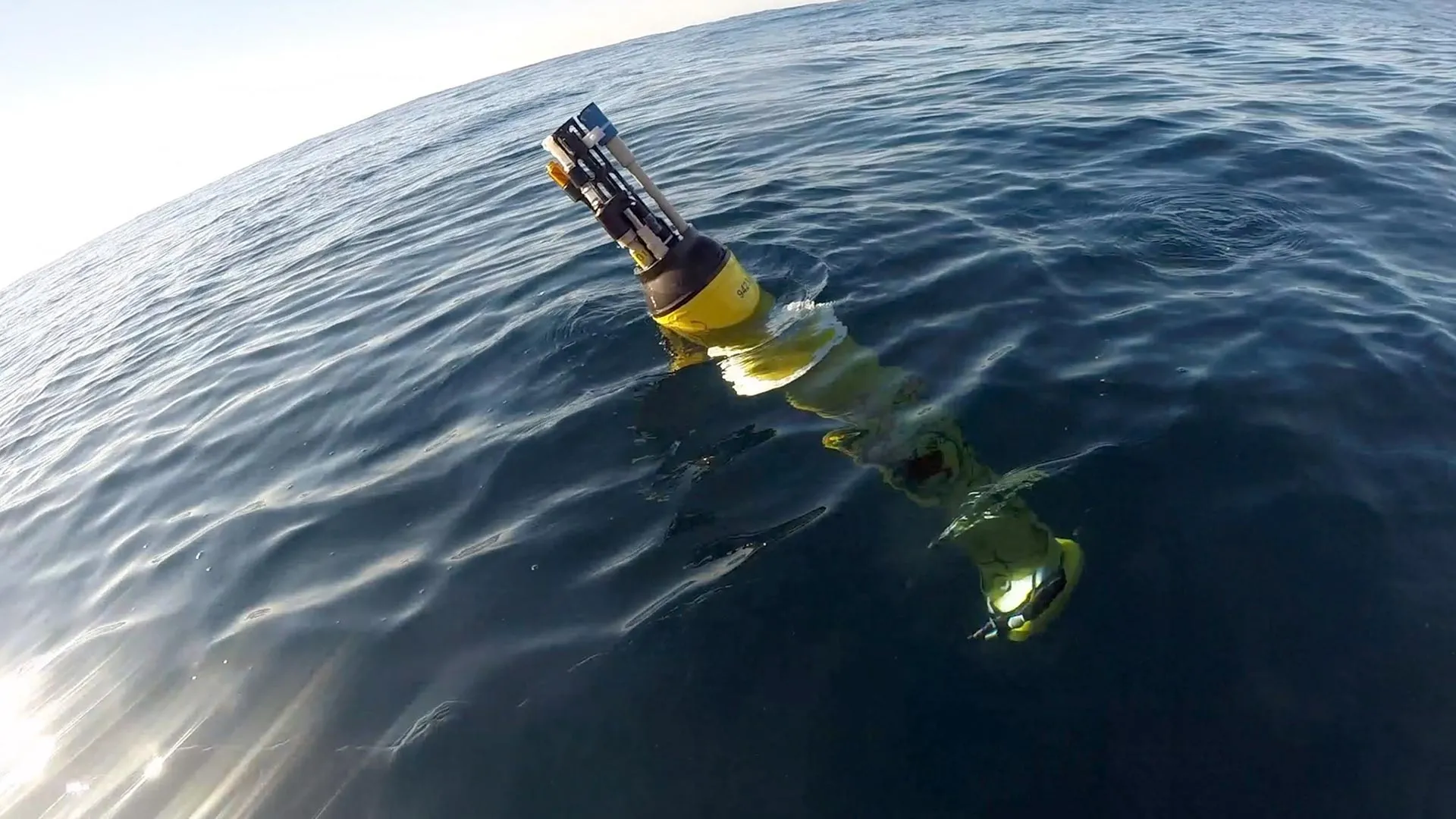
Robotic floats can continuously collect detailed data about ocean conditions. A new study led by MBARI researchers from the Global Ocean Biogeochemistry Array project—with an interdisciplinary team of collaborators—has analyzed data from floats deployed in the Gulf of Alaska and records from ship-based plankton surveys and revealed that marine heatwaves reshape ocean food webs and affect the ocean’s ability to store carbon. Credit: © 2022 MBARI

New research shows that marine heatwaves can reshape ocean food webs, which in turn can slow the transport of carbon to the deep sea and hamper the ocean’s ability to buffer against climate change. The study, published in the scientific journal Nature Communications on October 6, was conducted by an interdisciplinary team of researchers from MBARI, the University of Miami Rosenstiel School of Marine, Atmospheric, and Earth Science, the Hakai Institute, Xiamen University, the University of British Columbia, the University of Southern Denmark, and Fisheries and Oceans Canada.

To explore the impacts of marine heatwaves on ocean food webs and carbon flows, the research team combined multiple datasets that tracked biological conditions in the water column in the Gulf of Alaska for more than a decade. This region experienced two successive marine heatwaves during this time, one from 2013 to 2015 known as “The Blob,” and another from 2019 to 2020.

“The ocean has a biological carbon pump, which normally acts like a conveyor belt carrying carbon from the surface to the deep ocean. This process is powered by the microscopic organisms that form the base of the ocean food web, including bacteria and plankton,” said the lead author, Mariana Bif, previously a research specialist at MBARI and now an assistant professor in the Department of Ocean Sciences at the Rosenstiel School. “For this study, we wanted to track how marine heatwaves affected those microscopic organisms to see if those impacts were connected to the amount of carbon being produced and exported to the deep ocean.”

The research team used information collected by the Global Ocean Biogeochemical (GO-BGC) Array, a collaborative initiative funded by the US National Science Foundation and led by MBARI that uses robotic floats to monitor ocean health. The GO-BGC project has deployed hundreds of autonomous biogeochemical Argo (BGC-Argo) floats, which measure ocean conditions such as temperature, salinity, nitrate, oxygen, chlorophyll, and particulate organic carbon (POC) up and down the water column every five to 10 days. The team also looked at seasonal data from ship-based surveys that tracked plankton community composition, including pigment chemistry and sequencing of the environmental DNA (eDNA) from seawater samples collected during the Line P program carried out by Fisheries and Oceans Canada.

The study found that marine heatwaves did impact the base of the ocean food web, and those impacts were connected to changes in the ways that carbon was cycled in the water column. However, the changes that occurred in the food web were not consistent across the two heatwaves.

Under typical conditions, plant-like phytoplankton convert carbon dioxide to organic material. These microorganisms are the foundation of the ocean food web. When they are eaten by larger animals and excreted as waste, they transform into organic carbon particles that sink from the surface through the ocean’s mesopelagic, or twilight, zone (200 to 1,000 meters, approximately 660 to 3,300 feet) and down to the deep sea. This process locks atmospheric carbon away in the ocean for thousands of years.

During the 2013-2015 heatwave, surface carbon production by photosynthetic plankton was high in the second year, but rather than sinking rapidly to the deep sea, small carbon particles piled up approximately 200 meters (roughly 660 feet) underwater.

During the 2019-2020 heatwave, there was record-high accumulation of carbon particles at the surface in the first year that could not be attributed to carbon production by phytoplankton alone. Instead, this accumulation was likely due to the recycling of carbon by marine life and the buildup of detritus waste. This pulse of carbon then sank to the twilight zone, but lingered at depths of 200 to 400 meters (roughly 660 to 1,320 feet) instead of sinking to the deep sea.

The team attributed these differences in carbon transport between the two heatwaves to changes in phytoplankton populations. These changes cascaded through the food web, leading to a rise in small grazers who do not produce fast-sinking waste particles, so carbon was retained and recycled at the surface and in the upper twilight zone rather than sinking to deeper depths.

“Our research found that these two major marine heatwaves altered plankton communities and disrupted the ocean’s biological carbon pump. The conveyor belt carrying carbon from the surface to the deep sea jammed, increasing the risk that carbon can return to the atmosphere instead of being locked away deep in the ocean,” said Bif.

This research demonstrated that not all marine heatwaves are the same. Different plankton lineages rise and fall during these warming events, underscoring the need for long-term, coordinated monitoring of the ocean’s biological and chemical conditions to accurately model the diverse, and expansive, ecological impacts of marine heatwaves.

“This research marks an exciting new chapter in ocean monitoring. To really understand how a heatwave impacts marine ecosystems and ocean processes, we need observation data from before, during, and after the event. This research included robotic floats, pigment chemistry, and genetic sequencing, all working together to tell the entire story. It’s a great example of how collaboration can help us answer key questions about the health of the ocean,” said MBARI Senior Scientist Ken Johnson, the lead principal investigator for the GO-BGC project and a coauthor of the study.

Ocean observations and models suggest that marine heatwaves have been expanding in size and intensifying over the past few decades. The ocean absorbs a quarter of the carbon dioxide emitted each year, thanks to the steady stream of carbon particles sinking from the surface to the deep sea. A warmer ocean can mean less carbon locked away, which in turn can accelerate climate change. Beyond the changes to carbon transport, the shifts in plankton at the foundation of the ocean food web have cascading impacts on marine life and human industry too.

“Climate change is contributing to more frequent and intense marine heatwaves, which underscores the need for sustained, long-term ocean monitoring to understand and predict how future marine heatwaves will impact ecosystems, fisheries, and climate,” said Bif.

This work was funded by the US National Science Foundation’s GO-BGC project (NSF Award 1946578 with operational support from NSF Award 2110258), with additional support from the David and Lucile Packard Foundation, China National Science Foundation (grant number: 42406099), Fundamental Research Funds for the Central Universities (grant number: 20720240105), Danish Center for Hadal Research (Grant No. DNRF145), and Fisheries and Oceans Line P program.

CLICK HERE FOR MORE INFORMATION

https://www.sciencedaily.com/releases/2025/10/251007081819.htm

Japan’s hot springs hold clues to the origins of life on Earth

These findings show how life adapted before photosynthesis reshaped the planet and may also guide the search for life on alien worlds.

Source:Institute of Science Tokyo

Summary:Billions of years ago, Earth’s atmosphere was hostile, with barely any oxygen and toxic conditions for life. Researchers from the Earth-Life Science Institute studied Japan’s iron-rich hot springs, which mimic the ancient oceans, to uncover how early microbes survived. They discovered communities of bacteria that thrived on iron and tiny amounts of oxygen, forming ecosystems that recycled elements like carbon, nitrogen, and sulfur.Share:


FULL STORY


Hot Springs Hold Clues to the Origins of Life
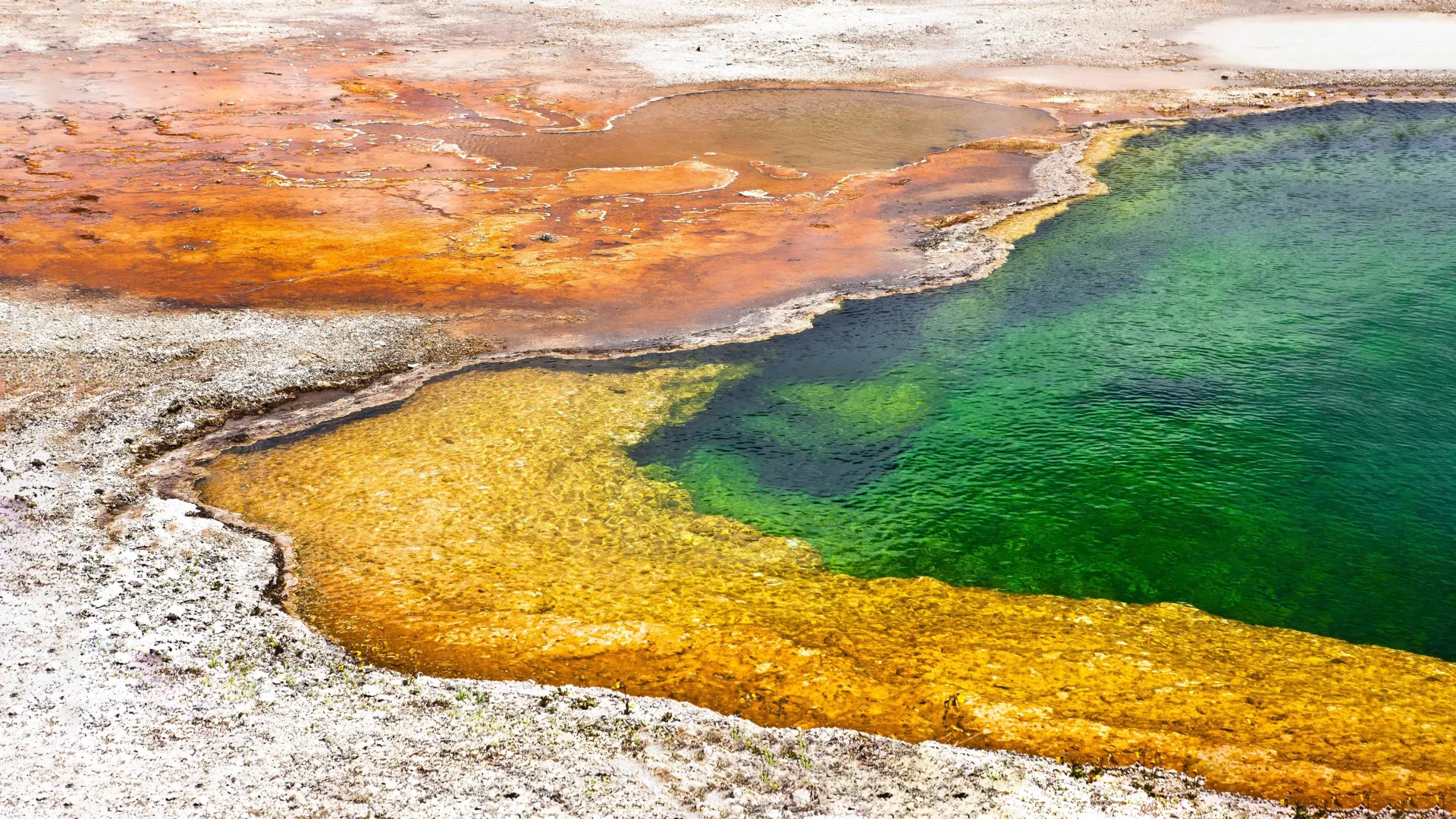
Ancient microbes survived by harnessing iron and low oxygen levels in ecosystems resembling modern hot springs in Japan. These discoveries illuminate how life adapted during Earth’s Great Oxygenation Event and hint at possible life strategies on other planets. Credit: Shutterstock

Earth was not always the blue-green world we know today: the early Earth’s oxygen levels were about a million times lower than we now experience. There were no forests and no animals. For ancient organisms, oxygen was toxic. What did life look like at that time then? A recent study led by Fatima Li-Hau (graduate student at ELSI at the time of the research) along with the supervisor Associate Professor Shawn McGlynn (at the time of research) of the Earth-Life Science Institute (ELSI) at Institute of Science Tokyo, Japan, explores this question by examining iron-rich hot springs that mimic the chemistry of Earth’s ancient oceans around the time of one of Earth’s most dramatic changes: the oxygenation of the atmosphere. Their findings suggest that early microbial communities used iron along with oxygen released by photosynthetic microbes, for energy, revealing a transitional ecosystem where life turned a waste product of one organism into a new energy source before photosynthesis became dominant.

The Great Oxygenation Event (GOE) occurred around 2.3 billion years ago and marked the rise of atmospheric oxygen, likely triggered by green Cyanobacteria that used sunlight to split water, subsequently converting carbon dioxide into oxygen through photosynthesis. The result is that the current atmosphere is around 78% nitrogen and 21% oxygen, with only traces of other gases such as methane and carbon dioxide, which might have played a greater role before the rise of oxygen. The GOE fundamentally changed the course of life on Earth. This high amount of oxygen allows us animals to breathe, but it also complicates life for ancient life forms, which were almost unaware of the O2 molecule. Understanding how these ancient microbes adapted to the presence of oxygen remains a major question.

To answer this, the team studied five hot springs in Japan, which are rich in varied water chemistries. Those five springs (one in Tokyo, two each in Akita and Aomori prefectures) are naturally rich in ferrous iron (Fe2+). They are rare in today’s oxygen-rich world because ferrous iron quickly reacts with oxygen and turns into an insoluble ferric iron form (Fe3+). But in these springs, the water still contains high levels of ferrous iron, low levels of oxygen, and a near-neutral pH, conditions thought to resemble parts of the early Earth’s oceans.

“These iron-rich hot springs provide a unique natural laboratory to study microbial metabolism under early Earth-like conditions during the late Archean to early Proterozoic transition, marked by the Great Oxidation Event. They help us understand how primitive microbial ecosystems may have been structured before the rise of plants, animals, or significant atmospheric oxygen,” says Shawn McGlynn, who supervised Li-Hau during her dissertation work.

In four of the five hot springs, the team found microaerophilic iron-oxidising bacteria to be the dominant microbes. These organisms thrive in low-oxygen conditions and use ferrous iron as an energy source, converting it into ferric iron. Cyanobacteria, known for producing oxygen through photosynthesis, were also present but in relatively small numbers. The only exception was one of the Akita hot springs, where non-iron-based metabolisms were surprisingly dominant.

Using metagenomic analysis, the team assembled over 200 high-quality microbial genomes and used them to analyse in detail the functions of microbes in the community. The same microbes that coupled iron and oxygen metabolism converted a toxic compound into an energy source and helped maintain conditions that allowed oxygen-sensitive anaerobes to persist. These communities carried out essential biological processes such as carbon and nitrogen cycling, and the researchers also found evidence of a partial sulfur cycle, identifying genes involved in sulfide oxidation and sulfate assimilation. Given that hot springs contained very little sulfur compounds, this was a surprising discovery. The researchers propose that this may indicate a “cryptic” sulfur cycle, where microbes recycle sulfur in complex ways that are not yet fully understood.

“Despite differences in geochemistry and microbial composition across sites, our results show that in the presence of ferrous iron and limited oxygen, communities of microaerophilic iron oxidisers, oxygenic phototrophs, and anaerobes consistently coexist and sustain remarkably similar and complete biogeochemical cycles,” says Li-Hau.

The research suggests a shift in our understanding of early ecosystems, showing that microbes may have harnessed energy from iron oxidation and oxygen produced by early phototrophs. The study proposes that, similar to these hot springs, early Earth hosted ecosystems were composed of diverse microbes, including iron-oxidising bacteria, anaerobes, and Cyanobacteria living alongside one another and modulating oxygen concentrations.

“This paper expands our understanding of microbial ecosystem function during a crucial period in Earth’s history, the transition from an anoxic, iron-rich ocean to an oxygenated biosphere at the onset of the GOE. By understanding modern analogue environments, we provide a detailed view of metabolic potentials and community composition relevant to early Earth’s conditions,” says Li-Hau.

Together, these insights deepen our understanding of life’s early evolution on Earth and have implications for the search for life on other planets with geochemical conditions similar to those of early Earth.

More information

Earth-Life Science Institute (ELSI) is one of Japan’s ambitious World Premiere International research centers, whose aim is to achieve progress in broadly inter-disciplinary scientific areas by inspiring the world’s greatest minds to come to Japan and collaborate on the most challenging scientific problems. ELSI’s primary aim is to address the origin and co-evolution of the Earth and life.

Institute of Science Tokyo (Science Tokyo) was established on October 1, 2024, following the merger between Tokyo Medical and Dental University (TMDU) and Tokyo Institute of Technology (Tokyo Tech), with the mission of “Advancing science and human wellbeing to create value for and with society.”

World Premier International Research Center Initiative (WPI) was launched in 2007 by Japan’s Ministry of Education, Culture, Sports, Science and Technology (MEXT) to foster globally visible research centers boasting the highest standards and outstanding research environments. Numbering more than a dozen and operating at institutions throughout the country, these centers are given a high degree of autonomy, allowing them to engage in innovative modes of management and research. The program is administered by the Japan Society for the Promotion of Science (JSPS).

CLICK HERE FOR MORE INFORMATION

https://www.sciencedaily.com/releases/2025/10/251002074009.htm

1,000 Swiss glaciers already gone, and the melting is speeding up

Source:ETH Zurich

Summary:Swiss glaciers lost nearly 3% of their volume in 2025, following a snow-poor winter and scorching summer heatwaves. The melt has been so extreme that some glaciers lost more than two meters of ice thickness in a single season. Scientists caution that the decline is destabilizing mountains, raising risks of rock and ice avalanches. Long-term monitoring efforts are now more critical than ever.Share:


FULL STORY


1,000 Swiss Glaciers Already Gone
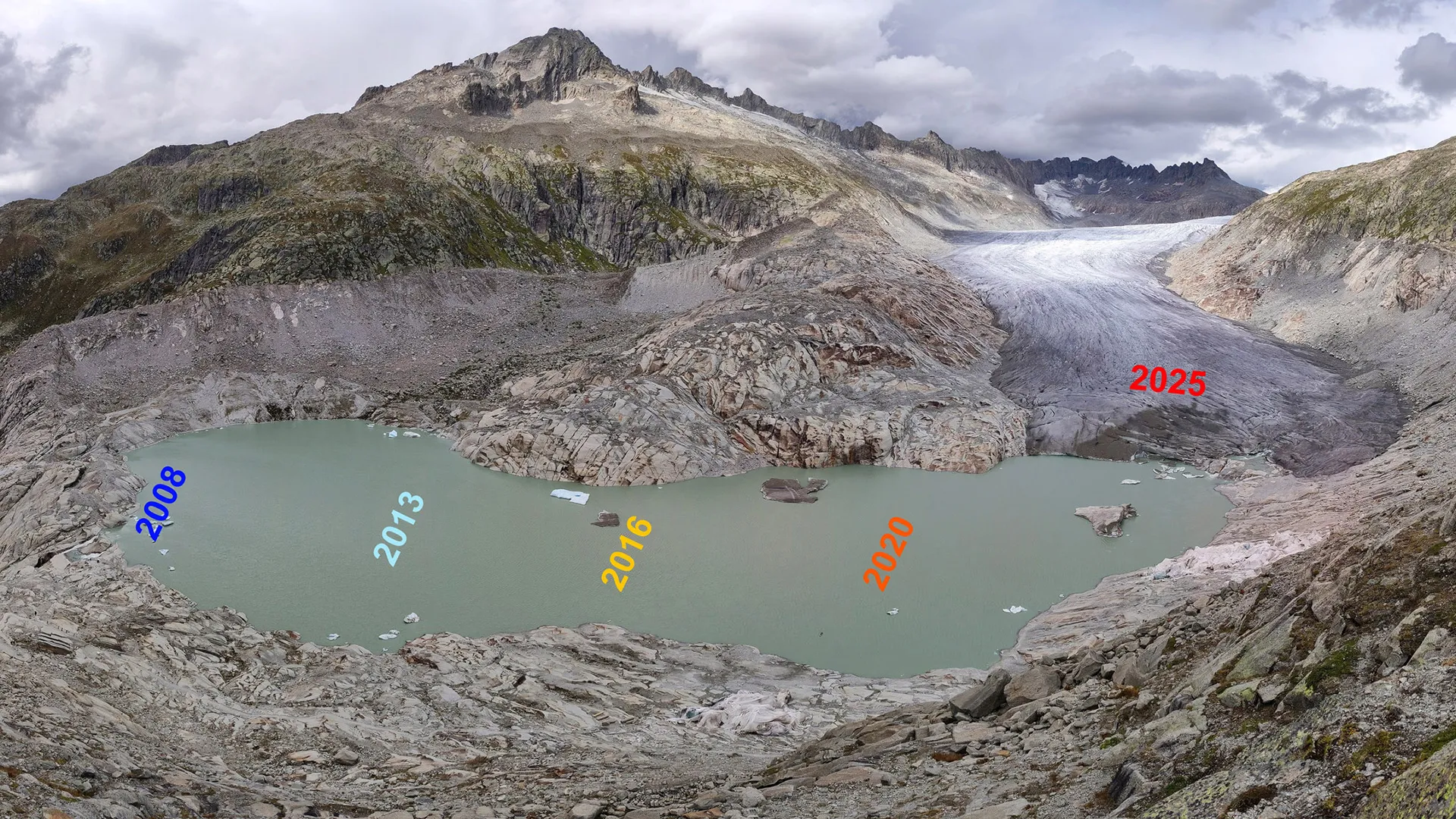
The lake in front of the Rhone Glacier, Canton Valais in Switzerland is expanding rapidly due to glacial retreat. Credit: Matthias Huss / VAW / ETH Zurich

Even the United Nations International Year of Glaciers’ Preservation has seen further massive melting of glaciers in Switzerland. A winter with little snow was followed by heat waves in June 2025 that saw glaciers nearing the record levels of losses of 2022. Snow reserves from the winter were already depleted in the first half of July, and the ice masses began to melt earlier than had rarely ever been recorded. The cool weather in July provided some relief and prevented an even worse outcome. Nevertheless, almost a further three per cent of the ice volume was lost across Switzerland this year, and this is the fourth greatest shrinkage after the years 2022, 2023 and 2003. 2025 therefore importantly contributed to the decade with the most rapid ice loss. Glaciers all over Switzerland have lost a quarter of their volume since 2015. Over 1,000 small glaciers have already disappeared.

In particular, glaciers from the winter disappeared there up to the summit level. As a consequence, the ice thickness on, for example, the Claridenfirn (Canton of Glarus), the Plaine Morte Glacier (Canton of Bern) and the Silvretta Glacier (Canton of the Grisons) reduced by over two meters. For glaciers in the southern Canton of Valais, such as the Allalin Glacier or Findel Glacier, the loss was less at around one meter.

Too little snow in winter

In the winter of 2024/2025, the combination of less precipitation and the third warmest six months of winter (October to March) since measurements began led to very low snow depths. For example, less fresh snow fell in parts of the northern and central Grisons than ever before. For this reason, around 13 per cent less snow was evident on the glaciers at the end of April when compared to the period from 2010 to 2020. The second warmest June since records began led to rapid melting of snow right up to the highest altitudes. Following a somewhat cool and damp July, August brought a heatwave with a high zero-degree line recorded in part at over 5,000 metres. In combination, this weather led to above-average temperatures in the summer. Between July and September, a few cold fronts resulted to individual days with fresh snow over 2,500 m above sea level, but this only remained for longer periods in high mountains.

“The continuous diminishing of glaciers also contributes to the destabilizing of mountains,” says Matthias Huss, Director of GLAMOS. “This can lead to events such as in the Lötschental valley where an avalanche of rock and ice buried the village of Blatten.”

The Swiss Commission for Cryosphere observation (SCC) of the Swiss Academy of Sciences (SCNAT) documents changes in the Alpine cryosphere. It coordinates the long-term Swiss monitoring networks created for snow, glaciers (GLAMOS) and permafrost (PERMOS). The Swiss Commission for Cryosphere observation (SCC) therefore represents those institutions that look after national monitoring networks, such as the Swiss Federal Institute for Forest, Snow and Landscape Research WSL, the Institute for Snow and Avalanche Research SLF, the Swiss Federal Office for Meteorology and Climatology (MeteoSchweiz), the Swiss Federal Institute of Technology in Zurich (ETH Zurich), theUniversities of Zurich, Fribourg and Lausanne and the University of Applied Sciences and Arts of Southern Switzerland (SUPSI), or who contribute financially to long-term safeguarding, such as the Swiss Federal Office for the Environment (FOEN), the Swiss Federal Office for Meteorology and Climatology (MeteoSwiss), in the context of the Swiss Global Climate Observing System (GCOS), the Swiss Academy of Sciences (SCNAT) and the Swiss Federal Office of Topography (swisstopo).

Further information

SCNAT – network of knowledge for the benefit of society The Swiss Academy of Sciences (SCNAT) and its network of 35,000 experts works at regional, national and international level for the future of science and society. It strengthens the awareness for the sciences as a central pillar of cultural and economic development. The breadth of its support makes it a representative partner for politics. The SCNAT links the sciences, provides expertise, promotes the dialogue between science and society, identifies and evaluates scientific developments and lays the foundation for the next generation of natural scientists. It is part of the association of the Swiss Academies of Arts and Sciences.

ETH Zurich — The program Glacier Monitoring in Switzerland (GLAMOS) aims to conduct a long-term study of glacier changes in the Swiss Alps. The service is maintained by ETH Zurich — the Swiss Federal Institute of Technology in Zurich, Switzerland, and involves the Department of Geosciences of the University of Fribourg, as well as the Department of Geography of the University of Zurich. The monitoring is coordinated by the Cryospheric Commission of the Swiss Academy of Sciences (CC/SCNAT) and receives financial support from the Federal Office for the Environment FOEN, MeteoSwiss within the framework of GCOS Switzerland, and the Swiss Academy of Sciences (SCNAT). Additional support is provided by the Federal Office of Topography swisstopo.

https://www.sciencedaily.com/releases/2025/10/251001092211.htm

Local News

Sewage spill in Annapolis creek leads to public health advisory

By Adam Thompson

A sewage spill in Boyds Creek off the South River in Annapolis has prompted a public health advisory, the Anne Arundel County Department of Health said.

The health department urges people not to swim, waterski, or have any direct water contact for a week. 

Public health advisory signs are posted as a reminder.

People who touch the affected water should wash well with soap and warm water immediately, and wash their clothing, the health department says.

6,100 gallons spilled

According to the Anne Arundel County Health Department, the Department of Public Works (DPW) stopped the leak and completed the repairs. 

https://cds.connatix.com/p/plugins/cnx.bridge-1.0.9-compressed.htmlThe video player is currently playing an ad.

The spill was contained, and it was a total of 6,100 gallons. 

DPW vacuumed all the standing water, cleaned the roadway, and spread lime on the grass.  

Recent fuel spill in Baltimore’s harbor

In June, a contractor for Johns Hopkins Hospital spilled at least 5,000 gallons of diesel fuel into Baltimore’s Inner Harbor.

The spill began on the Johns Hopkins Hospital campus on Fayette Street near Broadway when a contractor overfilled emergency generators. 

That diesel fuel washed through the storm drains to the Baltimore Harbor. 

Johns Hopkins has promised to pay to clean it up.

“As I spoke to [Baltimore Fire] Chief Wallace last night, he felt very confident we were in the place where we needed to be, being able to open up some of the roads and things like that,” Mayor Scott said. “The team has done a great job. We’ll just continue to monitor as we move forward and make the adjustments necessary. But as of right now, the remediation of this has gone as smoothly as possible,” Mayor Brandon Scott said.

More than 100 personnel from the U.S. Coast Guard, City Department of Public Works, and City Fire Department worked to contain the fuel. 

Crews used absorbent material and a skimmer to feed the fuel into a pump truck. The spill turned the harbor red due to the dye in the fuel, officials said. 

Baltimore City Fire Chief James Wallace said four contract companies were at the harbor with vacuum trucks and boats. The fire department opened fire hydrants in the area to flush the storm drain system and contain the fuel.

Contractors also skimmed the surface of the water to pull the fuel off the water and vacuumed it into the truck.

Wallace said the department is being proactive to prevent the spread of the fuel, using booms across the harbor. Several chains of absorbent material will take in oil, while the final boom will prevent it from spreading.

CLICK HERE FOR MORE INFORMATION

https://www.cbsnews.com/baltimore/news/sewage-spill-annapolis-boyds-creek-public-health-advisory-south-river/?intcid=CNM-00-10abd1h

Local News

Water restored in Novi area after transmission line break, many still under boil water advisory

By Paula Wethington,

 Nick Lentz

Water service was restored by Friday morning to the communities affected by a massive water main break Thursday morning in and near Novi, Michigan, the Great Lakes Water Authority says. 

But disruptions to daily routines, including boil water advisories, school closures and the road closing along 14 Mile Road continue for thousands of people who live, work or go to school in Commerce, Walled Lake and parts of Novi. The Great Lakes Water Authority has sent water trucks into the affected neighborhoods to help provide residents and businesses with water, and in some cases, businesses arranged for water bottles and portable toilets as a temporary step.

Repairs continue 

Great Lakes Water Authority, which is the regional water system in charge of the 42-inch transmission line that broke on 14 Mile Road, said utility crews worked all day Thursday and into the night to pressurize a 24-inch line and get water service restored. 

Service was returned to all affected communities by Friday morning, GLWA said, although utility crews will remain on site until repairs are complete on the 42-inch transmission line.

The City of Novi said its residents should be noticing improved water pressure, although it may not yet be at full strength. “The system is stable, but it’s a good idea to fill your bathtub or other containers with water as a backup supply in case service is interrupted again,” the city of Novi said Friday morning. 

City officials say it will take several weeks for repairs to be finished. Crews completed isolating the broken water main on Friday afternoon and are now flushing the system before water quality testing can start. 

Once flushing is complete, Great Lakes Water Authority crews will begin collecting water samples. Per state regulations, two consecutive clean samples must be taken 24 hours apart before a boil water advisory can be lifted. Novi officials said the first sample could be collected on Sunday “if all goes as planned.” 

Officials said on Saturday that it’s hopeful the advisory can be lifted on Tuesday, but asked residents to be prepared for it to remain in place until Wednesday in case more testing is needed. 

Currently, 14 Mile Road between Welch Road and M-5 will remain closed to through traffic. 

Boil water advisories 

The Great Lakes Water Authority lifted a boil water alert that was issued as a precaution for the City of Wixom late Thursday. 

boil-water-map-0926.jpg
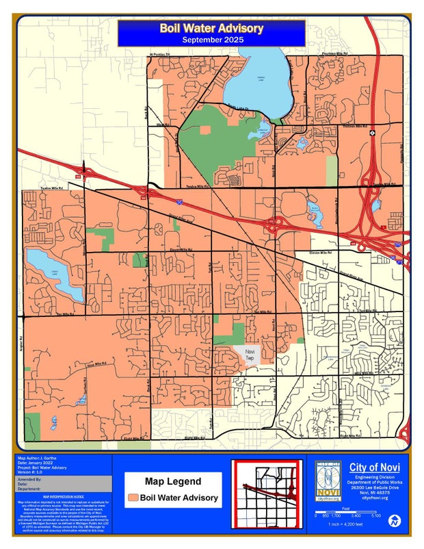
The city of Novi, Michigan, posted this map of a boil water advisory region on Sept. 26, 2025, the day after a massive water main break on 14 Mile Road.City of Novi, Michigan

But the boil water advisories for Walled Lake and the Novi neighborhoods that lost water remain in effect until further notice. The city of Novi said Friday morning that it expects the boil water advisory for its residents to remain in effect until Sunday.

Outdoor water use 

An outdoor water use restriction was posted for Novi and for nearby West Bloomfield, with residents asked to turn off irrigation systems to help ease water demand in the region.

GLWA didn’t specifically mention outdoor water use in its Friday morning report, but the water authority is asking all residents in the affected communities “to conserve water resources over the weekend to limit any additional stress on the system.”

School closures

Several schools in the affected communities were closed Thursday. The announcements for Friday include:

  • Novi Christian Academy announced it will be closed Friday. 
  • Detroit Catholic Central High School will be in session, but students are asked to bring their own water bottles.

CLICK HERE FOR MORE INFORMATION

https://www.cbsnews.com/detroit/news/water-main-break-novi-michigan-day-2/?intcid=CNM-00-10abd1h

Local News

Northfield, Minnesota warns residents of unsafe drinking water for infants

By Jason Rantala

In 2019, city officials in Northfield, Minnesota said the town’s water supply tested for high levels of manganese.

In high doses, the metal can cause memory, attention and motor skills problems for adults, and particularly impacts infants, according to the Minnesota Department of Health.

Earlier this year, the city scrapped plans to build a new water treatment facility because costs became too high, rising from $60 million to $83 million.

“Certainly we’re all committed to safe and healthy drinking water here in Northfield,” said Ben Martig, Northfield’s city administrator.

City officials are now advising families with infants under 1 to have them drink bottled water or to treat the water themselves, like with a reverse osmosis system.

Officials said they have been warning residents about the water quality issues for years through multiple press releases.

“We’ve talked with local providers, letting them know to notify pregnant mothers and newborn families that they should be looking at different options for their water and making sure that it is further treated,” said Justin Wagner, the city’s utilities manager.

“It’s unsafe for children under 1 and people who are pregnant, and those are important and valuable people to our community, too,” said Ward 1 City Council Member Kathleen Holmes.

She said water treatment is a city need, and costs for the project will only increase as time passes.

“This is a situation for renters who can’t put in reverse osmosis or can’t afford it,” said Holmes.

Northfield resident Levi Prinzing is the parent of an infant, but said at this point he’s more worried about the financial impacts of a new treatment facility. Prinzing also filters his water.

“I don’t think we need a new treatment plant,” said Prinzing. “The treatment plant is a lot of money and we just raised our taxes a lot.”

“We have to find a way to work together as a council and find a solution that can help bridge that gap, that we can provide safe drinking water for all residents, and hopefully reduce the financial impact or financial burden that it is on residents,” said Holmes.

The City Council may reconsider the water treatment facility in June.

CLICK HERE FOR MORE INFORMATION
https://www.cbsnews.com/minnesota/news/northfield-minnesotas-warns-residents-of-unsafe-drinking-water-for-infants/?intcid=CNM-00-10abd1h

Local News

Shedd Aquarium study on fish reproduction in Chicago River indicates continuing recovery from pollution

By Adam Harrington

A new study by the Shedd Aquarium has found that the Chicago River system continues to recover from pollution, as evidenced by the fish species that have been spawning in the river system.

A report on the study, “Larval fish community of the urbanized Chicago River,” was published Wednesday. It was authored by Dr. Austin Happel, a research biologist at the Shedd Aquarium who focuses on freshwater ecosystems.

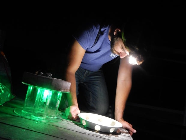
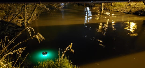
The study analyzed the species of fish that spawn in the Chicago River to sustain resilient and biodiverse fish communities, the Shedd explained in a news release. Using light traps at 10 locations in the river between 2020 and 2022, researchers collected 2,211 larval fish — and their DNA found the fish belonged to 24 different species.

light-trap-on-south-branch-of-river-1.jpg
A light trap on the South Branch of the Chicago River to capture fish larvae.Shedd Aquarium

“This research represents the first documentation of larvae from fish species occurring within the Chicago River, indicating that recovery and restoration efforts allow at least 24 species to successfully spawn and reach the larval stage,” Happel said in the news release. “Our previous studies showed that improvements to water quality in the river increased biodiversity, and now we have more positive news as populations are proliferating locally within the river.”

The Chicago River: A history of pollution

The reversal of the flow of the Chicago River is a point of Chicago pride that youngsters learn in history classes at local schools. On Jan. 2, 1900, the Sanitary District of Chicago — a predecessor to the Metropolitan Water Reclamation District — completed the massive undertaking by digging the 28-mile Sanitary and Ship Canal heading southwest out of the city.

Before the reversal, human and industrial waste would flow from the river right into Lake Michigan — the source of Chicago’s drinking water, then as now. The oft-repeated story that 90,000 people died of cholera and typhoid fever after a storm in Chicago sent sewage into the lake in 1885 has been debunked, but nevertheless, the flow of disgusting material from the river into the lake was a monumental public health hazard.

However, while the reversal of the flow of the river away from Lake Michigan protected the lake itself and the city’s drinking water, the Chicago River system remained polluted, neglected, and smelly as the city grew and developed.

As explained by Friends of the Chicago River, the city went on treating the river system like an alley — dumping trash and sewage and damaging conditions for people and wildlife alike.

“After more than 100 years of this abuse, the Chicago River and the others were so polluted that when the Clean Water Act passed in 1972, officials were convinced no one would ever want to fish or swim here — and set the standards incredibly low,” Friends of the Chicago River wrote.

But for half a century now, efforts have been under way to clean up the river. The Metropolitan Water Reclamation District of Greater Chicago set up the Deep Tunnel system to reduce flooding and improve waterway quality. Meanwhile, Friends of the Chicago River — founded in 1979 — undertook habitat restoration and long-range planning efforts for river improvement, with efforts ranging from planting wetlands vegetation to encouraging river-friendly land development.

Conditions on the Chicago River have improved to the point where a Chicago River Swim is set for this coming Saturday — the first such event in 95 years. The Shedd Aquarium study documents that the diversification of fish species in the river is also evidence that things are on the right track.

brh-5931.jpg
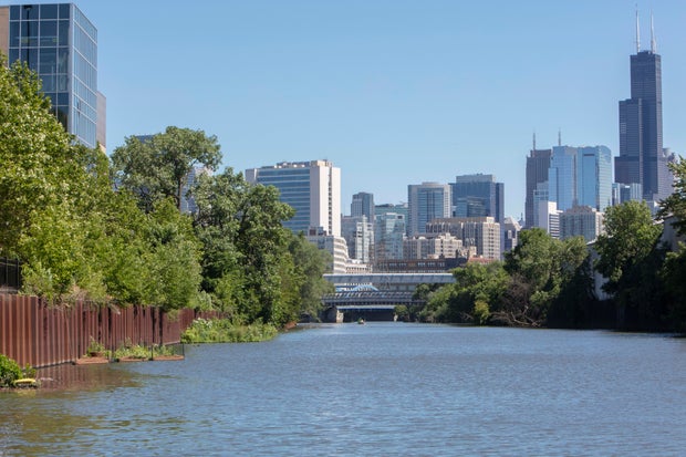
Chicago RiverBrenna Hernandez

Signs of hope in the Chicago River fish community

The fish community in the Chicago River has been rising in both numbers and species diversity since the 1970s as conditions in the river have improved, the Shedd Aquarium study said.

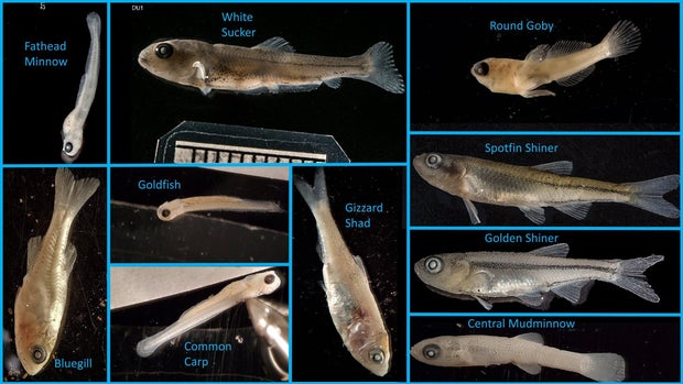
The study found species now reproducing in the Chicago River include popular sport fish like the black crappie, bluegill, and largemouth bass, and forage fish like the gizzard shad, golden shiner, and spotfin shiner. Larvae of brook silverside and mimic shiner were also found — which the Shedd found to be a pleasant surprise, as these fish were believed to be intolerant of pollution, the Shedd Aquarium said.

10-fish-species-1.jpg
Ten fish species found on the Chicago RiverShedd Aquarium

The peak abundance of fish larvae was found in July, as water temperatures reached the low 70s, the aquarium said.

The study also compared the fish larvae species found in the North Branch of the Chicago River versus the South Branch.

The North Branch of the River generally follows its historical path flowing southeast, though the North Shore Channel was dug between 1907 and 1910 to ensure further that sewage flowed into the river system and away from Lake Michigan. Before the flow reversal of 1900, the South Branch of the river flowed northeast into the Main Branch and on to Lake Michigan, but since the reversal, the South Branch has flowed southwest into the Sanitary and Ship Canal.

The Shedd Aquarium study found that species considered less tolerant of pollution were more common in the South Branch, while species more tolerant of pollution were seen more in the North Branch.

The finding indicates that “some combination of suitable substrate, submerged vegetation, and water quality and flow are most likely present in the South Branch.”

The study said these areas on the South Branch that may be favorable to the spawning of pollution-intolerant fish species could include backwater areas such as barge slips that are no longer used in Bubbly Creek. Bubbly Creek is the terminal South Fork of the river’s South Branch that was infamously once a dump site for animal remains from the Union Stockyards, but the study said the old barge slips may now be effective fish nursery habitats that offer both abundant food and protection from predators.

larval-sampling-north-side-jun-8-2020-1.jpg
Dr. Austin Happel studies fish larvae on the Chicago River.Shedd Aquarium

Happel is also researching how floating wetlands — which the Shedd Aquarium and the nonprofit Urban Rivers have been installing on the river system over the past several years — could also be affecting fish reproduction.

“As people continue to care about and conserve this critical freshwater ecosystem, we hope to see increases in the number of fish spawning in the system,” Happel said in the Shedd Aquarium news release. 

The aquarium said the study could be taken as a sign of hope for other heavily modified urban waterways, and insights on how to support fish communities to spawn and grow.

The study also demonstrates how restoration can return wildlife to a waterway, the aquarium said, emphasizing that healthy fish populations mean healthier aquatic environments overall.

The study was published in the Journal of Great Lakes Research.

CLICK HERE FOR MORE INFORMATION
https://www.cbsnews.com/chicago/news/shedd-aquarium-study-fish-reproduction-chicago-river/?intcid=CNM-00-10abd1h

Local News

Florida’s springs face pollution, climate threats as iconic waters risk losing natural beauty

Seen from the air, a Florida freshwater spring is a bit of liquid heaven, luring humans and wildlife to enjoy its aquamarine cool. With at least 1,000 of them — more than any other state — the springs serve as beaches for large swaths of central and northwestern Florida far from the ocean, with teenagers backflipping from docks and snorkelers peering into the crystalline depths.

But these treasures are under threat from agricultural pollution, rapid development and climate change.

Florida’s fragile freshwater springs under growing strain

Some places, such as fast-growing Zephyrhills in west-central Florida, have paused some construction as it struggles to stay within limits on the drinking water it can withdraw from a vast underground aquifer. Zephyrhills is home to Crystal Springs, source of the bottled water named after the town and several other brands.

“We really had to do something,” said Steven Spina, a member of the town council. “A lot of residents thought it was a good thing. People were happy to see us take a breath.”

The Floridan Aquifer: lifeline for 90% of the state’s drinking water

Covering an estimated 100,000 square miles (250,000 square kilometers), the underground Floridan Aquifer is the source of 90% of Florida’s drinking water. Because of the porous nature of the state’s bedrock, millions of gallons of water find their way to the surface in the form of clear, clean springs that, in turn, feed into rivers.

The highest concentration of springs are in central and northern Florida, including most of the 30 “first magnitude” springs — those that discharge at least 65 million gallons of water every day. All but four of them are considered polluted.

“We just have too much pollution going into the ground and too much water coming out of the ground,” said Ryan Smart, executive director of the nonprofit Florida Springs Council. “And when you get that combination, you end up with springs that are no longer blue and vibrant and full of life.”

Runoff, farming and algae blooms choke spring ecosystems

In rural Florida, runoff from fertilizers and pesticides used in farm fields is a major part of the problem. Fertilizers containing phosphates and nitrogen promote algae blooms that can suffocate a spring. Livestock waste contributes, too.

“When that algae covers everything, then you lose all of the seagrasses. The seagrasses are the forests of the water,” Smart said. “Then you begin to lose the biodiversity. And it even puts our drinking water at risk.”

Development and tourism add pressure to Florida’s springs

Elsewhere in Florida, rampant development is the threat. With over 1,000 people moving to Florida every day, more housing subdivisions are sprouting, along with the roads, strip malls, restaurants, golf courses and everything else that comes with them.

That means more paved surfaces that keep rainwater from percolating down into the aquifer and more pollutant-laden runoff from lawn fertilizers, parking lots, ever-widening roads and sometimes septic tanks. It also means more and more people, many of whom enjoy tubing, paddleboarding, kayaking and swimming in the springs.

It gets so busy in summer at some springs located in state and local parks that entry is halted by late morning. At Ichetucknee Springs State Park north of Gainesville, the daily limit of 750 tubers on the upper river is often reached within an hour after the park opens.

Kaelin Gibbs, on vacation in June with his family from Georgia, was swimming in the Blue Hole Spring along the Ichetucknee River.

“This is simply incredible; the water is cool and clear,” said Gibbs. “We’ve been to Florida’s beaches and to Orlando. There is no comparison to how beautiful this spring is.”

But that’s in peril, said Dennis Jones, a Republican former legislator deeply involved in springs issues. He said the volume of permits being issued for water use isn’t sustainable.

“You cannot keep taking water out of the aquifer because it’s not an endless supply,” Jones said.

Mining, climate change and saltwater intrusion worsen threats

Phosphate mining has also taken a toll on springs. Their operations require a great deal of water, which reduces water pressure available for springs. Some have died almost completely from mining and other factors, including White Sulphur Springs in north Florida, which was a sacred place for Native Americans and later a tourist resort that attracted famous visitors such as Henry Ford and Theodore Roosevelt.

A more subtle threat to the health of springs involves Earth’s changing climate. It is altering rainfall patterns around the globe, threatening the balance that feeds Florida’s springs.

In addition, some springs along the coasts are facing an intrusion of salt water, according to the Southwest Florida Water Management District. Four major springs are becoming increasingly brackish because of sea level rise and declining rainfall.

“As a result, freshwater vegetation has a hard time surviving in this saltier environment and unwanted vegetation moves in,” the district said in a website post.

State funding, lawsuits and grassroots activism aim to save springs

Florida spends billions every year on water quality projects, including about $800 million this year for Everglades restoration work. State funding for springs runs about $50 million a year, according to state documents.

Two state efforts at improving springs’ quality, both around a decade old, remain bottled up in court and administrative challenges. One would strengthen rules for permits to draw water from the major springs. The other would enhance rules to reduce the amount of nutrients such as nitrogen and phosphates that goes into springs that are considered impaired.

Jones, the former legislator, said lobbying by powerful agricultural interests and related political pressures have blocked progress on the nitrogen reduction plan that was expected to take about 20 years.

“We’ve burned up almost 10 years and they haven’t got on stage one. We got more nitrates now than when we started,” Jones said.

In Congress, U.S. Rep. Randy Fine recently filed a bill that would create a Florida Springs National Park across several counties, centered around the Ocala National Forest. Fine said in a statement the designation would protect the springs and increase funding. “Our Florida springs are something unique, not just to Florida but to the country,” Fine said.

It costs bottling companies just $115 for a permit allowing them to withdraw millions of gallons of water in perpetuity. But they do pay local taxes.

Blue Triton, the company that bottles Zephyrhills water, pays about $600,000 a year in taxes for things like schools, public safety and so forth, said Spina of the city council.

“They are one of our largest taxpayers,” he said.

Though they have challenges, Florida’s freshwater springs have energetic friends, too.

Michelle Jamesson loves the springs; she grew up swimming in one and is determined to help protect them for future generations. She volunteers for SpringsWatch Citizen Science Program, coordinating and working with other volunteers for monthly tests on the Wekiva River, north of Orlando.

They test water quality, take photos of underwater vegetation, count birds and more, seeking to spot any big changes that may require action. The Wekiva is fairly stable, she said, though it carries a lot of excess nutrients.

“The wildlife and the ecology, and all of it — it’s so full of life,” Jamesson said.

___

The Associated Press receives support from the Walton Family Foundation for coverage of water and environmental policy. The AP is solely responsible for all content. For all of AP’s environmental coverage, visit https://apnews.com/hub/climate-and-environment.

CLICK HERE FOR MORE INFORMATION
https://www.cbsnews.com/miami/news/florida-springs-water-pollution-climate-change-report/?intcid=CNM-00-10abd1h