Earlier this year, the city scrapped plans to build a new water treatment facility because costs became too high, rising from $60 million to $83 million.
“Certainly we’re all committed to safe and healthy drinking water here in Northfield,” said Ben Martig, Northfield’s city administrator.
City officials are now advising families with infants under 1 to have them drink bottled water or to treat the water themselves, like with a reverse osmosis system.
Officials said they have been warning residents about the water quality issues for years through multiple press releases.
“We’ve talked with local providers, letting them know to notify pregnant mothers and newborn families that they should be looking at different options for their water and making sure that it is further treated,” said Justin Wagner, the city’s utilities manager.
“It’s unsafe for children under 1 and people who are pregnant, and those are important and valuable people to our community, too,” said Ward 1 City Council Member Kathleen Holmes.
She said water treatment is a city need, and costs for the project will only increase as time passes.
“This is a situation for renters who can’t put in reverse osmosis or can’t afford it,” said Holmes.
Northfield resident Levi Prinzing is the parent of an infant, but said at this point he’s more worried about the financial impacts of a new treatment facility. Prinzing also filters his water.
“I don’t think we need a new treatment plant,” said Prinzing. “The treatment plant is a lot of money and we just raised our taxes a lot.”
“We have to find a way to work together as a council and find a solution that can help bridge that gap, that we can provide safe drinking water for all residents, and hopefully reduce the financial impact or financial burden that it is on residents,” said Holmes.
The City Council may reconsider the water treatment facility in June.
Florida’s springs face pollution, climate threats as iconic waters risk losing natural beauty
Seen from the air, a Florida freshwater spring is a bit of liquid heaven, luring humans and wildlife to enjoy its aquamarine cool. With at least 1,000 of them — more than any other state — the springs serve as beaches for large swaths of central and northwestern Florida far from the ocean, with teenagers backflipping from docks and snorkelers peering into the crystalline depths.
But these treasures are under threat from agricultural pollution, rapid development and climate change.
Florida’s fragile freshwater springs under growing strain
Some places, such as fast-growing Zephyrhills in west-central Florida, have paused some construction as it struggles to stay within limits on the drinking water it can withdraw from a vast underground aquifer. Zephyrhills is home to Crystal Springs, source of the bottled water named after the town and several other brands.
“We really had to do something,” said Steven Spina, a member of the town council. “A lot of residents thought it was a good thing. People were happy to see us take a breath.”
The Floridan Aquifer: lifeline for 90% of the state’s drinking water
Covering an estimated 100,000 square miles (250,000 square kilometers), the underground Floridan Aquifer is the source of 90% of Florida’s drinking water. Because of the porous nature of the state’s bedrock, millions of gallons of water find their way to the surface in the form of clear, clean springs that, in turn, feed into rivers.
The highest concentration of springs are in central and northern Florida, including most of the 30 “first magnitude” springs — those that discharge at least 65 million gallons of water every day. All but four of them are considered polluted.
“We just have too much pollution going into the ground and too much water coming out of the ground,” said Ryan Smart, executive director of the nonprofit Florida Springs Council. “And when you get that combination, you end up with springs that are no longer blue and vibrant and full of life.”
Runoff, farming and algae blooms choke spring ecosystems
In rural Florida, runoff from fertilizers and pesticides used in farm fields is a major part of the problem. Fertilizers containing phosphates and nitrogen promote algae blooms that can suffocate a spring. Livestock waste contributes, too.
“When that algae covers everything, then you lose all of the seagrasses. The seagrasses are the forests of the water,” Smart said. “Then you begin to lose the biodiversity. And it even puts our drinking water at risk.”
Development and tourism add pressure to Florida’s springs
Elsewhere in Florida, rampant development is the threat. With over 1,000 people moving to Florida every day, more housing subdivisions are sprouting, along with the roads, strip malls, restaurants, golf courses and everything else that comes with them.
That means more paved surfaces that keep rainwater from percolating down into the aquifer and more pollutant-laden runoff from lawn fertilizers, parking lots, ever-widening roads and sometimes septic tanks. It also means more and more people, many of whom enjoy tubing, paddleboarding, kayaking and swimming in the springs.
It gets so busy in summer at some springs located in state and local parks that entry is halted by late morning. At Ichetucknee Springs State Park north of Gainesville, the daily limit of 750 tubers on the upper river is often reached within an hour after the park opens.
Kaelin Gibbs, on vacation in June with his family from Georgia, was swimming in the Blue Hole Spring along the Ichetucknee River.
“This is simply incredible; the water is cool and clear,” said Gibbs. “We’ve been to Florida’s beaches and to Orlando. There is no comparison to how beautiful this spring is.”
But that’s in peril, said Dennis Jones, a Republican former legislator deeply involved in springs issues. He said the volume of permits being issued for water use isn’t sustainable.
“You cannot keep taking water out of the aquifer because it’s not an endless supply,” Jones said.
Mining, climate change and saltwater intrusion worsen threats
Phosphate mining has also taken a toll on springs. Their operations require a great deal of water, which reduces water pressure available for springs. Some have died almost completely from mining and other factors, including White Sulphur Springs in north Florida, which was a sacred place for Native Americans and later a tourist resort that attracted famous visitors such as Henry Ford and Theodore Roosevelt.
A more subtle threat to the health of springs involves Earth’s changing climate. It is altering rainfall patterns around the globe, threatening the balance that feeds Florida’s springs.
In addition, some springs along the coasts are facing an intrusion of salt water, according to the Southwest Florida Water Management District. Four major springs are becoming increasingly brackish because of sea level rise and declining rainfall.
“As a result, freshwater vegetation has a hard time surviving in this saltier environment and unwanted vegetation moves in,” the district said in a website post.
State funding, lawsuits and grassroots activism aim to save springs
Florida spends billions every year on water quality projects, including about $800 million this year for Everglades restoration work. State funding for springs runs about $50 million a year, according to state documents.
Two state efforts at improving springs’ quality, both around a decade old, remain bottled up in court and administrative challenges. One would strengthen rules for permits to draw water from the major springs. The other would enhance rules to reduce the amount of nutrients such as nitrogen and phosphates that goes into springs that are considered impaired.
Jones, the former legislator, said lobbying by powerful agricultural interests and related political pressures have blocked progress on the nitrogen reduction plan that was expected to take about 20 years.
“We’ve burned up almost 10 years and they haven’t got on stage one. We got more nitrates now than when we started,” Jones said.
In Congress, U.S. Rep. Randy Fine recently filed a bill that would create a Florida Springs National Park across several counties, centered around the Ocala National Forest. Fine said in a statement the designation would protect the springs and increase funding. “Our Florida springs are something unique, not just to Florida but to the country,” Fine said.
It costs bottling companies just $115 for a permit allowing them to withdraw millions of gallons of water in perpetuity. But they do pay local taxes.
Blue Triton, the company that bottles Zephyrhills water, pays about $600,000 a year in taxes for things like schools, public safety and so forth, said Spina of the city council.
“They are one of our largest taxpayers,” he said.
Though they have challenges, Florida’s freshwater springs have energetic friends, too.
Michelle Jamesson loves the springs; she grew up swimming in one and is determined to help protect them for future generations. She volunteers for SpringsWatch Citizen Science Program, coordinating and working with other volunteers for monthly tests on the Wekiva River, north of Orlando.
They test water quality, take photos of underwater vegetation, count birds and more, seeking to spot any big changes that may require action. The Wekiva is fairly stable, she said, though it carries a lot of excess nutrients.
“The wildlife and the ecology, and all of it — it’s so full of life,” Jamesson said.
___
The Associated Press receives support from the Walton Family Foundation for coverage of water and environmental policy. The AP is solely responsible for all content. For all of AP’s environmental coverage, visit https://apnews.com/hub/climate-and-environment.
Why thousands of people in rural West Virginia lack reliable drinking water
By Tom Hanson
Rhodell, West Virginia — For as long as Roman Patsey of Raleigh County, West Virginia, remembers, the Appalachian Mountains have provided virtually everything he’s needed to survive, from his income as a coal miner, to his tap water.
“I don’t know if it’s safe or not to tell you the truth,” Patsey told CBS News of his tap water source. “But, you know, what are you going to do? You’ve got to drink water.”
He took CBS News to his only source of drinking water for nearly 50 years: an abandoned coal mine near his home. Like so many here, he dug his own trenches and laid his own water lines hundreds of feet up a mountainside.
He says no part of him wondered why access to water should be this difficult.
“No, I just accepted it,” Patsey said. “It was something you had to do. I worried about running out of water, really, for years.”
He said he has never conducted regular tests on the water for possible contaminants
About 250,000 West Virginia residentsrely on untreated sources of water, like natural springs or aquifers from coal mines, according to the Environmental Protection Agency. The median income in this area is around $30,000 per year, according to U.S. Census data, a far cry from the prosperity that the coal industry once created. Coal companies used to fund and operate many town water systems in rural West Virginia. But when the industry declined, so did the water infrastructure it used to maintain. Patsey wanted to see this firsthand. So he, with a CBS News crew in tow, went to a water treatment plant in nearby Kimball, a town of more than 300 people in McDowell County. The plant’s windows are boarded up, the roof is completely missing, and there is rusted metal. Yet, this facility is supposed to clean tap water for the entire community.
Just 20 minutes up the road in Rhodell, a community in Raleigh County, the water treatment plant is also crumbling, with rust covering the pipes and a ceiling that is caved in.
“It’s in pretty bad shape as you can see,” said Shane Bragg with the Raleigh County Public Service District. “The fear is what you can’t see underground and what’s in the mines. We have no way of accessing the pumps in the mines, so when they go, the town will lose water.”
Raleigh County is racing to replace water systems before that happens with help from the nonprofit DigDeep, which works to bring clean tap water to the more than 2.2 million Americans who it says are living without it.
“We’re dealing with a lot of systems that are very expensive to maintain,” said Travis Foreman, director of DigDeep’s Appalachia Water Project. “And the local public service districts, they don’t have the manpower to keep up.”
In Rhodell, DigDeep is bringing clean water to the community for the first time in 10 years. “It is a human right to have access to water,” Foreman said. “…Everyone deserves to have that access.”
For Patsey, it’s a source of hope straight from the tap.
“Not long ago at 4 o’clock in the morning, I turned this on like this, not a drop,” Patsey said while standing at his kitchen sink. “It’s such a peace knowing I’m going to have water here.”
Summary:A study shedding new light on how arsenic can be made less dangerous to humans has the potential to dramatically improve water and food safety, especially in the Global South.Share:
FULL STORY
A study led by the University of Bristol shedding new light on how arsenic can be made less dangerous to humans has the potential to dramatically improve water and food safety, especially in the Global South.
For the lead researcher it’s an academic and personal mission because he witnessed first-hand the constant struggle to find clean, arsenic-free water as a child in India.
Lead author Dr Jagannath Biswakarma, Senior Research Associate at the University’s School of Earth Sciences, said: “There are millions of people living in regions affected by arsenic, like I was growing up. This breakthrough could pave the way for safer drinking water and a healthier future.”
Arsenic pollution exposure is a huge environmental and public health issue in southern and central Asia and South America, where people depend on groundwater for drinking and farming. The more toxic and mobile form of arsenic, called arsenite, easily seeps into water supplies and can lead to cancers, heart disease and other serious conditions.
Dr Biswakarma said: “I’ve seen the daily battle for safe drinking water in my hometown Assam. It’s very hard to find groundwater sources that aren’t contaminated with arsenic, so for me this research hits close to home. It’s an opportunity to not only advance science, but also better understand the extent of a problem which has affected so many people in my own community and across the world for many decades.”
Scientists previously believed arsenite could only be turned into the less harmful form, called arsenate, with oxygen. But this new study has shown it can still be oxidised, even in the absence of oxygen, with small amounts of iron which act as a catalyst for oxidation.
Dr Biswakarma said: “This study presents a new approach to addressing one of the world’s most persistent environmental health crises by showing that naturally occurring iron minerals can help oxidise, lowering the mobility of arsenic, even in low-oxygen conditions.”
Study findings revealed that arsenite could be oxidised by green rust sulfate, a source of iron prevalent in low-oxygen conditions, such as groundwater supplies. They also showed this oxidation process is further enhanced with a chemical released by plants and commonly found in soils and groundwater.
“These organic ligands, such a citrate from plant roots, could play a critical role in controlling arsenic mobility and toxicity in natural environments,” Dr Biswakarma added.
The implications of this discovery are particularly significant for regions in the Global South facing some of the world’s highest levels of arsenic pollution. In countries such as India and Bangladesh, the local geology is rich in iron, and reducing conditions often dominate in groundwater systems, leading to high levels of arsenic contamination. In the Ganges-Brahmaputra-Meghna Delta, which spans Bangladesh and eastern India, millions of people have been exposed to arsenic-contaminated groundwater for decades as the chemical enters the water through natural processes.
Dr Biswakarma said: “Many households rely on tube wells and hand pumps, but these systems do not guarantee access to clean water. The water often cannot be used for drinking or other household tasks due to its toxicity, odour, and discoloration. Additionally, there is an ongoing financial burden associated with obtaining new tube wells or hand pumps. As a result, economically disadvantaged families continue to struggle to find safe water for their daily needs.”
Similarly, the Mekong Delta and the Red River Delta, in Vietnam, face ongoing challenges with arsenic pollution, affecting drinking water supplies and agricultural productivity. Rice paddies can become hotspots of arsenic exposure, as the toxic chemical can accumulate in soil and be absorbed by rice plants, posing a further health risk through food consumption.
“The research opens the door for developing new strategies to mitigate arsenic pollution. Understanding the role of iron minerals in arsenic oxidation could lead to innovative approaches to water treatment or soil remediation, using natural processes to convert arsenic into its less harmful form before it enters drinking water supplies,” said co-author Molly Matthews, who worked on the paper during her Masters degree in Environmental Geoscience at the University of Bristol.
Identifying the specific form of arsenic in a sample can be challenging. Even a trace amount of oxygen can convert arsenite into arsenate, so it is vital to protect samples from exposure to air. Thanks to funding from the European Synchrotron Radiation Facility (ESRF) the team was able to conduct these complex experiments at its XMaS synchrotron facility, in Grenoble, France.
Co-author Dr James Byrne, Associate Professor of Earth Sciences, added: “Determining arsenic formation at the atomic level using X-ray absorption spectroscopy was crucial for confirming changes to the arsenic oxidation state. The synchrotron therefore played a pivotal role in supporting our findings, which have potentially broad implications for our understanding of water quality.”
This work at University of Bristol was supported through a UK Research & Innovation (UKRI) Future Leaders Fellowship (FLF) awarded to Dr James Byrne. Further research is now needed to explore how these findings can be applied in real-world settings.
Dr Biswakarma said: “The whole research team worked tirelessly on this project, putting in 24/7 shifts including over Easter to conduct the experiments in France.
“I genuinely believe, with more work, we can find effective possible solutions and we’re already making great inroads to overcoming this big global issue. We’re excited to investigate how this process might work in different types of soils and groundwater systems, especially in areas where arsenic contamination is most severe.”
Finding bold answers to big questions concerning global challenges is at the heart of the University of Bristol’s research. This study cuts across core themes, including advancing equitable and sustainable health, and driving forward social justice.
Optimal water intake is without a doubt one of the most vital factors in good health. In essence, we need the proper amount of water in our bodies for every cellular function. Even mild dehydration leads to fatigue, brain fog, headaches and dizziness. However, the subject of water and hydration also happens to be one of the most confusing topics – how much water we should drink? What’s the best type of water to drink; distilled, alkaline, spring, sparkling, still, or some other type? In this article, we will seek to answer these questions and then some. As we evolve this topic, there is something key to keep in mind; it’s not just about how much water you consume. More importantly in the world of hydration is that your cells actually utilize that water efficiently.
Cellular Hydration: Beyond Water Deficiency
While not drinking enough water is the easiest way to become dehydrated, it’s not the only way. The truth is, just like food, water needs to be metabolized. Many people eat enough, but still end up nutritionally deficient due to poor digestion and a sluggish metabolism. Similarly, many people drink more than enough water, yet their bodies are starved for water. How can this be? First, understand that the amount of water a person needs is extremely variable; it depends on various things such as metabolic rate, physical activity, and even the temperature and humidity of the air. For example, working out hard in hot, dry weather, it’s possible to drink more than two quarts and not produce any urine because that water is lost by evaporation or “burned up” by the increased metabolic rate of that active person. On the other hand, a person with a sluggish metabolism, even in hot, humid conditions can be endangered by too much water. These are only two examples, but in reality, anything that affects the physiology of a person can potentially create a stress and therefore affect cellular hydration and the way the body uses water.
Stress & Hydration
Any stress on the body, and stress being defined as anything that may interfere with energy production, can potentially disturb the interactions between water and the cell. Stress causes “excitation” and this causes a cell to take up extra water. In fact, it is well known that the tissues of people with hypothyroid (a stress condition) tend to hold more water; this is referred to as edema, a common symptom of hypothyroid. 1 There are other ways that stress can cause dehydration. Under a stress response, the body secretes an excess of the stress hormone cortisol. Cortisol has a feedback loop with estrogen, so as cortisol increases, estrogen also increases. It is well known that estrogen causes sodium loss, and has a high affinity to water. In other words, when the cell is stressed, under the influence of estrogen, it tends to uptake more water and swell (edema), causing both a loss of sodium and water. Additionally, stress causes the increase of hormones like aldosterone, which cause the kidneys to secrete excess sodium in the urine and sweat and the cells to hold water. This loss of sodium causes a vicious cycle to occur because when there isn’t enough sodium, more aldosterone is synthesized, which leads to the increased loss of electrolytes like potassium, magnesium, and calcium. The loss of potassium leads to something called vasoconstriction, which means vascular motility is decreased, contributing to heart and kidney failure and high blood pressure. In these ways, stress of any sort can cause the increase of stress hormones that alter the cells’ ability to interact with water. This can lead to the loss of sodium and the excess uptake of water into the cells causing not only dehydration but edema. To conclude, “stress” is the true cause of dehydration because it interferes with the proper cellular interaction with water. However, because stress can occur in endless ways, here are some other probable causes of dehydration to keep in mind:
A sodium-deficient diet: salt has been demonized in this society; however, it is necessary for proper kidney function, mineral/fluid balance and therefore the cellular regulation of water.
Drinking only still water: Most of our water today is either contaminated with fluoride, heavy metals and other toxins, or it is so filtered that it is lacking in necessary minerals like sodium, potassium, and magnesium. So if you suspect you suffer from dehydration yet drink enough water, it might not be enough to drink “filtered water”, you might need to enhance it with minerals, mineral-rich salt or purchase mineralized waters like Gerolsteiner.
Vigorous exercise: During times of increased physical activity or exercise, the body undergoes an acute stress response, resulting in the loss electrolytes. The best ways to offset this process is to avoid over-exercising, keep cool (avoid exercising in too intense of heat), increase your intake of sodium and consume more water than usual. Be sure to drink 16 ounces of mineralized (add TraceMinerals or Real Salt) to your water before a workout, one during and one immediately after.
Chronic Alcohol Consumption: Alcohol is a stress on the liver for a few reasons but most trace back to its estrogenic effects. Estrogen interferes with metabolic function (including water metabolism), and estrogen causes the loss of sodium in the cell. In one study, the ingestion of alcohol is known to negatively affect the hypothalamo-neurohypophysial system resulting in increased diuresis, dehydration and hyperosmolality. 2
Symptoms of Dehydration
Feeling incredibly thirsty is only one symptom of dehydration. As mentioned, water is essential for all physiological functions, therefore, the signs of dehydration can also include:
Considering the roles water plays in digestion, metabolism, immunity and detoxification, and the consequences of destination, it is vital to know how to stay hydrated properly.
Secrets to Healthy Hydration
By now, it is clear to see that hydration is not merely a game of “drinking enough” but also entails stress management (of all sorts), and keeping a proper balance of minerals and water in the body. If you’re wondering how to achieve these goals, here are some tips that you may not have considered before…
Lower Stress Hormones: As we learned, it is estrogen and aldosterone which ultimately lead to cellular dehydration. These hormones cause the loss of sodium, interfering with the proper interactions between our cells and water. Therefore, as strange as it seems, keeping stress to a minimum is an essential part in proper hydration. Here are some ways to lower these stress hormones;
Consume Healthy Salt: When it comes to proper hydration, one of the most important things to consider is the balance between minerals and water. Sodium, potassium and magnesium play an equally important role in hydration as water. However, in our culture, the extra water consumption, combined with a low salt diet is perhaps the worst hydration advice one could get – especially for an already stressed person, let’s say with hypothyroidism. The truth is, salt has an anti-stress effect, capable of mitigating the secretion of stress hormones like cortisol and aldosterone. Also, it’s well known that when the body is stressed, it loses sodium. With that being said, a smarter piece of advice would be to cautiously avoid the overconsumption of still (mineral-deficient) water and underconsumption of salt. Instead, consume healthy amounts of salt (we like Redmond’s Real Salt and Himalayan), and be sure to choose quality water.
Avoid Over Drinking Water: Despite what most of us have learned in America, when our bodies are healthy, we don’t need as much water as we are told. As we have discussed, too much water accompanied by the lack of sodium and stress can lead to edema, swelling and tension. So, if you are the type of person to “chug” copious amounts of water (especially still, plain water) you may want to make a few adjustments. In regards to water intake, this is a matter of quality over quantity. If you’re generally healthy, not overly stressed and you eat a whole-foods diet, it’s likely you do not need as much water as you think. Whole foods contain a generous supply of water, especially fruits, vegetables, broths, etc.
Tap Water Toxicity: For some, tap water toxicity seems like a conspiracy, but the fact of the matter is there is a known presence of toxins in our water supply. In fact, one study by the Environmental Working Group has discovered 316 chemicals in tap water throughout the country, including dangerous chemicals, compounds and metals. 4, 5
Choosing the Best Water
Not all water is created equally; some water contains harmful toxins, others simply lack the precious minerals or electrolytes needed for the proper cellular utilization of water. With this in mind, the water you choose to drink can play a large role in how well your body is hydrated. Here are some of our top picks for water:Sparkling Mineral Water: Sparkling water may be an acquired taste. However, if you have been dehydrated for some time and haven’t known it, once you start, it will be difficult to go back. Not only is sparkling mineral water rich in the exact minerals we need for the cellular utilization of water, but it also contains CO2(carbon dioxide), which has many helpful benefits. For thousands of years, the therapeutic value of carbonated mineral springs has been acknowledged. In fact, the theory that ‘living water’s’ gas content had therapeutic benefits led researcher Joseph Priestley to investigate ways to make carbonated water, and in the process he discovered oxygen. Carbonated water had its medical vogue in the 19th century, but the modern medical establishment has mostly chosen to ignore these effects. However, if we consider that CO2 is the basic metabolic byproduct of healthy cellular respiration, it would make sense that the ingestion of even small amounts of CO2 is beneficial on overall metabolism. Not to mention, sparkling water has a better mouth feel and is also typically rich in important minerals like sodium. Our favorite picks for sparkling are Pellegrino and Gerolsteiner. Both waters are premium, mineral-rich, carbonated waters. However, Pellegrino appears to be much richer in sulfates. Sulfates (sulfur) are a necessary part of a healthy diet. Sulfur is the 8th most common element in the human body and while it is not FDA recommended, the fact is, sulfur is necessary for many important physiological functions including collagen formation, detoxification (especially of cysteine and methionine, two harmful amino acids when in excess), the production of master antioxidant glutathione, and the regulation of inflammation prostaglandins, amongst others. So in our understanding and research, the consumption of these sparkling mineral waters is highly therapeutic! 6Distilled: Distillation is a simple water purification process where water is brought to a boil and converted to steam. The steam flows through cooling tubes and condenses back into water for drinking. The major benefit of this process is that it removes all potentially harmful contaminants, additives, organisms and other toxins. The downside to distilled water is that it lacks any beneficial minerals; however, these can be easily added with a mineral supplement or a pinch of high-mineral salt. One last thing to keep in mind with distilled water is the possibility of serious contamination. If the pre-distilled water contained any volatile organic compounds like chlorine, as the water is vaporized it can actually become concentrated in the finished distilled water. This would create a final product that contains even more dangerous contaminants than it was prior to distilling. Spring Water:True spring water might make for a good choice for water consumption. First, spring water usually contains an ideal pH. Where distilled water is likely too acidic and alkaline water is too alkaline for drinking, mountain spring water is usually in an ideal neutral range. Some also consider wild spring water to be the healthiest water simply because it is in its most natural state, the way nature intended. Like raw food, living spring water contains “biophotons”, small units of light stored which activate the mitochondria. Also, let’s not forget that spring water is free! There’s a very helpful website you can utilize called FindaSpring.com where you can find local, safe springs.
Conclusion
Staying properly hydrated is not just beneficial for plumper, moisturized skin, it goes way beyond that to affect every single cellular process in your body. So tell us… What are your secrets to staying hydrated? Have you experienced any benefits when addressing your water and electrolyte intake? Leave us a comment below!
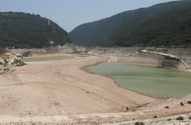
QARAOUN, Lebanon (Reuters) -Water levels at Lebanon’s largest reservoir on the Litani River have fallen to historic lows amid what experts describe as the country’s worst drought on record, threatening agriculture, electricity production, and domestic water supplies.
The Litani River National Authority said inflows to Lake Qaraoun during this year’s wet season did not exceed 45 million cubic metres, a fraction of the 350 million cubic metres annual average.
Last year, the figure stood at 230 million. The water currently available in Lake Qaraoun – around 61 million cubic meters – was unusable due to severe pollution, the authority said.
“There were dry years in 1989, 1990 and 1991, but this year is the driest,” said Sami Alawieh, head of the river authority. “We are facing a water scarcity problem across all Lebanese territories and water basins.”
Drone footage of Lake Qaraoun shows a dramatically receded shoreline, exposing cracked earth and dead vegetation.
Lebanon’s hydroelectric plants tied to the Litani basin have been shut down, Alawieh said, causing financial losses and intensifying electricity rationing by Electricite du Liban.
“We have two factors: the decline in rainfall and the pressure on groundwater,” he said.
A study by the authority found climate warming and shifting weather patterns have contributed to more frequent dry seasons and higher temperatures, exacerbating soil moisture loss and reducing the recharging of groundwater reservoirs.
The state utility has slashed supply in some areas from 20 hours a day to as little as 10.
In the fertile area around Qaraoun village, in the Bekaa Valley, farmers were already feeling the impact.
“I have never seen such drought or scarcity of rain as this year,” said Safa Issa. “We used to get snow up to a metre high. Now, it’s been 10 years since we’ve seen any.”
The strain has been compounded by erratic supply of electricity needed to run irrigation systems.
“You irrigate for three hours, then stop for three,” said Fayez Omais, another local farmer.
Suzy Hoayek, an adviser to the Ministry of Energy and Water in Beirut, said a nationwide awareness campaign to reduce consumption would be launched within 10 days.
“The most important thing is to manage demand,” she said.
The Michigan Department of Environment, Great Lakes and Energy has issued a report that there are “significant deficiencies” in the management of Wyandotte’s water system.
But the city says the water is safe, adding “it consistently meets or exceeds all state and federal water quality standards.”
“There is no known current risk to public health from the City’s drinking water, and we are fully committed to maintaining that record,” the city said on its website.
The respective statements spin out of a notice that Michigan EGLE issued April 30, citing “significant deficiencies” in the areas of treatment, distribution system, finished water storage and management/operations. The letter was also sent to the Wayne County Health Department.
“The most significant observations during the Survey are the need for adequate investment in capital improvement projects, completion of maintenance activities, and adequate investment in staffing,” EGLE said in its letter. “There are several indications the City is not keeping up with capital investments, especially in the distribution system and future operational and maintenance needs may overwhelm the available budget and resources.”
The four matters listed as significant deficiencies were:
Failure to keep up with an inspection schedule for backflow prevention and cross-connections.
Damage to the vents at one reservoir.
Assorted debris, such as tennis balls and beverage containers, was found at another reservoir.
A water treatment process that didn’t include a specified method of mixing the treatment chemical into the raw water.
The city was given 120 days to either correct the significant deficiencies noted or submit a “corrective action plan” that EGLE will review.
There were also other matters noted as deficiencies, such as an inspection report that showed zebra mussels found near an entrance to a water intake pipe, and routine maintenance schedules, such as hydrant flushing that was not implemented “due to inadequate staffing.”
In addition, the city of Wyandotte has not included fluoride treatment for several years. “If fluoride treatment is not continued, the appropriate local procedures need to be followed,” the letter says. “It is imperative for the water supply to notify the public so residents can make informed decisions about their oral health.”
On that detail, the city has replied, “Fluoridation of drinking water is not required by law. The City discontinued fluoride treatment in 2015 during a treatment plant rehabilitation project. Fluoride levels are monitored and disclosed in the City’s annual Consumer Confidence Reports, and residents are encouraged to consult with their dental professionals about supplemental fluoride needs.”
Wyandotte officials say after the April report was issued, the city’s Municipal Services took steps toward “actively addressing all recommendations.” This includes a series of repairs at the reservoirs and evaluation of its filtration method.
In the meantime, the EGLE staff noted that during the three years before its report was issued, the city had taken a number of steps to address water facility operations and improvements.
Water scarcity threatens the health and development of communities around the globe. Climate change is intensifying the problem, pushing governments to find more innovative, collaborative ways to address water stress.
New Delhi residents fill containers with drinking water from a municipal tanker in June 2018. Adnan Abidi/Reuters
Water scarcity happens when communities can’t fulfill their water needs, either because supplies are insufficient or infrastructure is inadequate. Today, billions of people face some form of water stress.
Countries have often cooperated on water management. Still, there are a handful of places where transboundary waters are driving tensions, such as the Nile Basin.
Climate change will likely exacerbate water stress worldwide, as rising temperatures lead to more unpredictable weather and extreme weather events, including floods and droughts.
Introduction
Billions of people around the world lack adequate access to one of the essential elements of life: clean water. Although governments and aid groups have helped many living in water-stressed regions gain access in recent years, the problem is projected to get worse due to global warming and population growth. Meanwhile, a paucity of international coordination on water security has slowed the search for solutions.
Water stress can differ dramatically from one place to another, in some cases causing wide-reaching damage, including to public health, economic development, and global trade. It can also drive mass migrations and spark conflict. Now, pressure is mounting on countries to implement more sustainable and innovative practices and to improve international cooperation on water management.
Water stress or scarcity occurs when demand for safe, usable water in a given area exceeds the supply. On the demand side, the vast majority—roughly 70 percent—of the world’s freshwater is used for agriculture, while the rest is divided between industrial (19 percent) and domestic uses (11 percent), including for drinking. On the supply side, sources include surface waters, such as rivers, lakes, and reservoirs, as well as groundwater, accessed through aquifers.
Daily News Brief
A summary of global news developments with CFR analysis delivered to your inbox each morning. Weekdays.
But scientists have different ways of defining and measuring water stress, taking into account a variety of factors including seasonal changes, water quality, and accessibility. Meanwhile, measurements of water stress can be imprecise, particularly in the case of groundwater. “Any numbers out there have to be taken with a grain of salt,” says Upmanu Lall, a Columbia University professor and water expert. “None of these definitions are typically accounting for groundwater usage, or groundwater stock.”
What causes water scarcity?
Water scarcity is often divided into two categories: physical scarcity, when there is a shortage of water because of local ecological conditions; and economic scarcity, when there is inadequate water infrastructure.
The two frequently come together to cause water stress. For instance, a stressed area can have both a shortage of rainfall as well as a lack of adequate water storage and sanitation facilities. Experts say that even when there are significant natural causes for a region’s water stress, human factors are often central to the problem, particularly with regard to access to clean water and safe sanitation. Most recently, for example, the war in Ukraine damaged critical infrastructure, leaving six million people with limited or no access to safe water in 2022.
“Almost always the drinking water problem has nothing to do with physical water scarcity,” says Georgetown University’s Mark Giordano, an expert on water management. “It has to do with the scarcity of financial and political wherewithal to put in the infrastructure to get people clean water. It’s separate.”
At the same time, some areas that suffer physical water scarcity have the infrastructure that has allowed life there to thrive, such as in Oman and the southwestern United States.
A variety of authorities, from the national level down to local jurisdictions, govern or otherwise influence the water supply. In the United States, more than half a dozen federal agencies deal with different aspects of water: the Environmental Protection Agency (EPA) enforces regulations on clean water, while the Federal Emergency Management Agency (FEMA) prepares for and responds to water disasters. Similar authorities exist at the state and local levels to protect and oversee the use of water resources, including through zoning and rehabilitation projects.
Which regions are most water-stressed?
The Middle East and North Africa (MENA) is the worst off in terms of physical water stress, according to most experts. MENA receives less rainfall than other regions, and its countries tend to have fast-growing, densely populated urban centers that require more water. But many countries in these regions, especially wealthier ones, still meet their water needs. For example, the United Arab Emirates (UAE) imports nearly all of its food, alleviating the need to use water for agriculture. The UAE and other wealthy MENA countries also rely heavily on the desalination of abundant ocean water, albeit this process is an expensive, energy-intensive one.
Water Stress Is a Global Challenge
Darker shaded areas have more physical water stress; but myriad factors, including infrastructure, governance, and population, all contribute to water availability.
Physical water stress in 2014, defined as withdrawals as a share of renewable surface and groundwater supplies> 80%40–80%20–40%10–20%< 10%Arid and low water useDCABE
+-
One in three members of the Navajo Nation lacks running water, while non-Navajos nearby generally have indoor plumbing.A
For centuries, Italy’s aquifers provided easy access to clean water, but the now outdated infrastructure is putting pressure on the country.B
The DRC has over half of Africa’s water reserves, but millions of Congolese don’t have access to clean water, contributing to disease and malnutrition.C
On top of Yemen’s physical water scarcity, years of war have wiped out water services, leaving millions without basic water supplies.D
India is among the most water-stressed countries, in part due to its population, pollution, and the exploitation of groundwater.E
Sources: National Geographic; Navajo Water Project; UNICEF; World Resources Institute; WRI Aqueduct.
Meanwhile, places experiencing significant economic scarcity include Central African countries such as the Democratic Republic of Congo, which receives a lot of rain but lacks proper infrastructure and suffers from high levels of mismanagement.
Even high-income countries experience water stress. Factors including outdated infrastructure and rapid population growth have put tremendous stress on some U.S. water systems, causing crises in cities including Flint, Michigan, and Newark, New Jersey.
How is climate change affecting water stress?
For every 1°C (1.8°F) increase in the global average temperature, UN experts project a 20 percent dropin renewable water resources. Global warming is expected to increase the number of water-stressed areas and heighten water stress in already affected regions. Subtropical areas, such as Australia, the southern United States, and North African countries, are expected to warm and suffer more frequent and longer droughts; however, when rainfall does occur in these regions, it is projected to be more intense. Weather in tropical regions will likewise become more variable, climate scientists say.
Agriculture could become a particular challenge. Farming suffers as rainfall becomes more unpredictable and rising temperatures accelerate the evaporation of water from soil. A more erratic climate is also expected to bring more floods, which can wipe out crops an overwhelm storage systems. Furthermore, rainfall runoff can sweep up sediment that can clog treatment facilities and contaminate other water sources.
In a 2018 report, a panel consisting of many of the world’s top climate researchers showed that limiting global warming to a maximum 1.5°C (2.7°F) above preindustrial levels—the aim of the Paris Agreement on climate—could substantially reduce the likelihood of water stress in some regions, such as the Mediterranean and southern Africa, compared to an unchecked increase in temperature. However, most experts say the Paris accord will not be enough to prevent the most devastating effects of climate change.
What are its impacts on public health and development?
Prolonged water stress can have devastating effects on public health and economic development. More than two billion people worldwide lack access to safe drinking water; and nearly double that number—more than half the world’s population—are without adequate sanitation services. These deprivations can spur the transmission of diseases such as cholera, typhoid, polio, hepatitis A, and diarrhea.
At the same time, because water scarcity makes agriculture much more difficult, it threatens a community’s access to food. Food-insecure communities can face both acute and chronic hunger, where children are more at risk of conditions stemming from malnutrition, such as stunting and wasting, and chronic illnesses due to poor diet, such as diabetes.
Even if a water-stressed community has stable access to potable water, people can travel great lengths or wait in long lines to get it—time that could otherwise be spent at work or at school. Economists note these all combine [PDF] to take a heavy toll on productivity and development.
Living in a Water-Stressed World
A housing development lies on the edge of Cathedral City, a desert resort town in southern California, in April 2015.Damon Winter/New York Times/Redux
The COVID-19 pandemic heightened the need for safe water access. Handwashing is one of the most effective tools for combating the coronavirus, but health experts noted that three in ten individuals—2.3 billion people globally—could not wash their hands at home at the pandemic’s onset.
How has water factored into international relations?
Many freshwater sources transcend international borders, and, for the most part, national governments have been able to manage these resources cooperatively. Roughly three hundred international water agreements have been signed since 1948. Finland and Russia, for example, have long cooperated on water-management challenges, including floods, fisheries, and pollution. Water-sharing agreements have even persisted through cross-border conflicts about other issues, as has been the case with South Asia’s Indus River and the Jordan River in the Middle East.
However, there are a handful of hot spots where transboundary waters are a source of tension, either because there is no agreement in place or an existing water regime is disputed. One of these is the Nile Basin, where the White and Blue Nile Rivers flow from lakes in East Africa northward to the Mediterranean Sea. Egypt claims the rights to most of the Nile’s water based on several treaties, the first dating back to the colonial era; but other riparian states say they are not bound to the accords because they were never party to them. The dispute has flared in recent years after Ethiopia began construction of a massive hydroelectric dam that Egypt says drastically cuts its share of water.
Ethiopian Dam Ignites Tensions With Egypt, Sudan Over Nile Waters
Flow
direction
Cairo
Sources of Nile
River water in Egypt
EGYPT
Blue Nile: 57%
White Nile: 31%
Other: 12%
Lake
Nasser
RED
SEA
Nile
SUDAN
Khartoum
White Nile
Blue Nile
ETHIOPIA
SOUTH
SUDAN
Grand Ethiopian
Renaissance Dam
Lake Victoria
Sources: Mada Masr; UN Food and Agriculture Organization.
Transboundary water disputes can also fuel intrastate conflict; some observers note this has increased in recent years, particularly in the hot spots where there are fears of cross-border conflict. For example, a new hydropower project could benefit elites but do little to improve the well-being of the communities who rely on those resources.
Moreover, water stress can affect global flows of goods and people. For instance, wildfires and drought in 2010 wiped out Russian crops, which resulted in a spike in commodities prices and food riots in Egypt and Tunisia at the start of the Arab uprisings. Climate stress is also pushing some to migrate across borders. The United Nations predicts that without interventions in climate change, water scarcity in arid and semi-arid regions will displace hundreds of millions of people by 2030.
What are international organizations and governments doing to alleviate water stress?
There has been some international mobilization around water security. Ensuring the availability and sustainable management of water and sanitation for all is one of the UN Sustainable Development Goals (SDGs), a sweeping fifteen-year development agenda adopted by member states in 2015. Smart water management is also vital to many of the other SDGs, such as eliminating hunger and ensuring good health and well-being. And while the Paris Agreement on climate does not refer to water explicitly, the United Nations calls [PDF] water management an “essential component of nearly all the mitigation and adaptation strategies.” The organization warns of the increasing vulnerability of conventional water infrastructure, and points to many climate-focused alternatives, such as coastal reservoirs and solar-powered water systems.
However, there is no global framework for addressing water stress, like there is for fighting climate change or preserving biodiversity. The most recent UN summit on water, held in March 2023, was the first such conference since 1977 and didn’t aim to produce an international framework. It instead created a UN envoy on water and saw hundreds of governments, nonprofits, and businesses sign on to a voluntary Water Action Agenda, which analysts called an important but insufficient step compared to a binding agreement among world governments.
Some governments and partner organizations have made progress in increasing access to water services: Between 2000 and 2017, the number of people using safely managed drinking water and safely managed sanitation services rose by 10 percent and 17 percent, respectively. In 2022, the Joe Biden administration announced an action planto elevate global water security as a critical component of its efforts to achieve U.S. foreign policy objectives. But the pace of climate change and the COVID-19 pandemic have presented new challenges. Now, many countries say they are unlikely to implement integrated water management systems by 2030, the target date for fulfilling the SDGs.
Still, some governments are taking ambitious and creative steps to improve their water security that could serve as models for others:
Green infrastructure. Peruvian law mandates that water utilities reinvest a portion of their profits into green infrastructure (the use of plant, soil, and other natural systems to manage stormwater), and Canada and the United States have provided tens of millions of dollars in recent years to support Peru’s efforts [PDF]. Vietnam has taken similar steps to integrate natural and more traditional built water infrastructure.
Wastewater recycling. More and more cities around the globe are recycling sewage water into drinking water, something Namibia’s desert capital has been doing for decades. Facilities in countries including China and the United States turn byproducts from wastewater treatment into fertilizer.
Smarter agriculture. Innovations in areas such as artificial intelligence and genome editing are also driving progress. China has become a world leader in bioengineering crops to make them more productive and resilient.
Recommended Resources
The Wilson Center’s Lauren Risi writes that water wars between countries have not come to pass, but subnational conflicts over the resource are already taking a toll.
CFR’s Why It Matters podcast talks to Georgetown University’s Mark Giordano and the Global Water Policy Project’s Sandra Postel about water scarcity.
The World Economic Forum describes the growing water crisis in the Horn of Africa, while National Geographic looks at how the prolonged drought is pushing wildlife closer to towns.
The World Resources Institute’s Aqueduct maps the areas facing extremely high water stress.
The United Nations shares facts about water and its role in all aspects of life.
BuzzFeed News interviews residents of Jackson, Mississippi, who lost access to safe water after freezing temperatures wreaked havoc on the city’s decaying infrastructure.
Nairobi, 28 August 2024 – In half the world’s countries one or more types of freshwater ecosystems are degraded, including rivers, lakes and aquifers. River flow has significantly decreased, surface water bodies are shrinking or being lost, ambient water is growing more polluted, and water management is off-track. These are some of the findings of three reports tracking progress on freshwater, published today by UN-Water and the UN Environment Programme (UNEP).
The triennial series of reports is focused on progress towards achieving the goal of “clean water and sanitation for all” (SDG 6) through protecting and restoring freshwater sources. Based on greater data sets than ever before, the reports reiterate the call to scale up support for Member States in tackling challenges through the UN System-wide strategy for water and sanitation and the accompanying upcoming Collaborative Implementation Plan.
“Our blue planet is being rapidly deprived of healthy freshwater bodies and resources, with dire prospects for food security, climate change and biodiversity,” said Dianna Kopansky, Head of the Freshwater and Wetlands Unit, Ecosystems Division at UNEP. “At this critical point, global political commitments for sustainable water management have never been higher, including through the passing of a water resolution at the last UN Environment Assembly in February, but they are not being matched by required finance or action. Protection and restoration policies, tailored for different regions, are halting further loss and show that reversing degradation is within reach. We absolutely need more of them.”
Widespread degradation
A reported 90 countries, most in Africa, Central- and Southeast Asia, are experiencing the degradation of one or more freshwater ecosystems. Other regions, such as Oceania, mark improvements. Pollution, dams, land conversion, over-abstraction and climate change contribute to degradation of freshwater ecosystems.
Influenced by climate change and land use, river flow has decreased in 402 basins worldwide – a fivefold increase since 2000. A much smaller number is gaining in river flow.
Loss of mangroves due to human activities (e.g., aquaculture and agriculture) poses a risk to coastal communities, freshwater resources, biodiversity, and climate due to their water filtration and carbon sequestering properties. Significant decreases of mangroves were reported in Southeast Asia, though the overall net rate of deforestation has leveled off in the last decade.
Lakes and other surface water bodies are shrinking or being lost entirely in 364 basins worldwide. A continued high level of particles and nutrients in many large lakes can lead to algal blooms and low-oxygen waters, primarily caused by land clearance and urbanization, and certain weather events.
Nevertheless, the construction of reservoirs contributes to a global net-gain in permanent water, mainly in regions like North America, Europe, and Asia.
Low levels of water quality monitoring
The poorest half of the world contributes under 3 per cent of global water quality data points, including only 4,500 lake quality measurements out of almost 250,000. This reveals an urgent need to improve monitoring capacity.
Lack of data on this scale means that by 2030 over half of humanity will live in countries that have inadequate water quality data to inform management decisions related to address drought, floods, impacts from wastewater effluents and agricultural runoff.
Where good data are available, it shows that freshwater quality has been degrading since 2017. Where data are lacking, the signs are not promising.
Report authors recommend the expansion and development of routine government-funded monitoring programmes, as well as incorporating citizen science into such national programmes, and exploring the potential of satellite-based Earth observation and modelled data products to help fill the data gap.
Inadequate progress on water resources management in over 100 countries
Balancing competing needs for sustainable water use from society and the economy requires the implementation of integrated water resources management (IWRM) across sectors, at all levels and across borders by 2030.
47 countries have fully reached or almost reached IWRM, 63 countries need to accelerate implementation, while 73 countries have only limited capacity for IWRM. At the current rate of reported progress, the world will only achieve sustainable water management by 2049. This means that by 2030 at least 3.3 billion people in over 100 countries are likely to have ineffective governance frameworks to balance competing water demands.
Solutions include unlocking finance through revenue raising and cost recovery arrangements, investments in infrastructure and management, as well as coordinated action, greater institutional capacity and better monitoring networks.
NOTES TO EDITORS
About the UN Environment Programme (UNEP) UNEP is the leading global voice on the environment. It provides leadership and encourages partnership in caring for the environment by inspiring, informing and enabling nations and peoples to improve their quality of life without compromising that of future generations.
About UN-Water UN-Water coordinates the UN’s work on water and sanitation. It is comprised of UN Members States and international organizations working on water and sanitation issues. UN-Water’s role is to ensure that Members and Partners ‘deliver as one’ in response to water-related challenges.
If you think the water you are drinking is just H2O, think again! According to studies, an astonishing 75,000 chemical compounds have been found in our water, yet the EPA has established enforceable safety standards for only 87. Many of these common water contaminants and chemicals are potentially harmful and can spawn health problems. According to the Centers for Disease Control and Prevention, nearly one million people get sick from drinking contaminated water each year, with about 1,000 cases on average ending in death.
Using outdated technology, many municipalities simply weren’t built to handle the influx of common modern-day water contaminants. Various pollutants such as pesticides, herbicides, toxic waste from landfills, chemical and oil spills, acid rain, and more find their way into our water supplies. Most often this water is treated with chlorine or chloramines to control bacterial growth which, according to some health experts, may also contribute to illness.
Even if the water that leaves the treatment plants meets EPA minimum safety standards, health threats don’t stop there. The water may pass through unsafe water lines that recontaminate it on the way to your home. Examine your pipes and those of water distribution systems and you’ll find the insides of some of these pipes caked with mineral, biological and chemical deposits. In some cases, the pipes themselves may leach copper and lead! Another threat lurking inside older water pipes is bio-film, composed of layers of bacteria that can harbor pathogens like E. coli. And don’t think well water is any safer because groundwater pollutants may also seep into that source. Add to that the chlorine and other chemicals used to treat well water, and you have water that is chemically altered.
The sad truth is that our water supply is compromised by harmful chemicals. EPA standards require water treatment plants to reduce certain common water contaminants. Annual reports issued by the EPA for 2002 indicated that there were 80,635 documented violations nationwide. When violations occur, “boil water” alerts are issued but, by then, you may have already consumed dangerously contaminated water.
You have to ask yourself the question, “Over the course of my life, how will these chemicals and trace pollutants affect my health and that of my family?” Consider what this means if, over the course of your life, you drink approximately 13,000 gallons of water. There could be undetected contaminants in each glass you drink having a cumulative effect on your health for the worse. That’s why it’s so important you make doubly sure the water you drink is 100% steam distilled. And with Waterwise’s distilled water-making machines, you can take control of your water quality today and enjoy peace of mind.