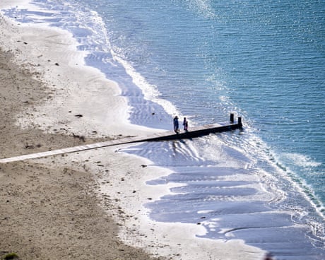
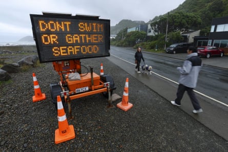
Abandoned beaches, public health warning signs and seagulls eating human waste are now features of the popular coastline in New Zealand
Michelle Duff in Wellington 22.42 ESTShare
Atide of anger is rising in New Zealand’s capital, Wellington, as the city’s toilets continue to flush directly into the ocean more than two weeks after the catastrophic collapse of its wastewater treatment plant.
Millions of litres of raw and partially screened sewage have been pouring into pristine reefs and a marine reserve along the south coast daily since 4 February, prompting a national inquiry, as the authorities struggle to get the decimated plant operational.
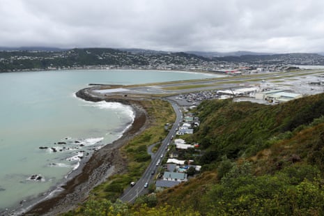
Abandoned beaches, public health warning signs and seagulls eating human waste are now features of the popular coastline, with the environmental disaster zone adjacent to the airport where thousands of international visitors alight every day.
Fears for the safety of marine ecosystems – including vulnerable species such as the little blue penguin, or kororā, which nest along the shore – are mixed with concerns over the length and cost of disruption to those who depend on the coast for income, wellness, and recreation.
As a southerly storm whipped through the lower North Island and churned up polluted seawater this week, hundreds of residents turned out to a public meeting to seek answers.
“They’re warning us to close our windows because a shit-laden hurricane is coming at us,” said the south coast resident and environmentalist Eugene Doyle, whose house faces the sea. “Everyone in charge has done an appalling job, and they need to be held accountable.”
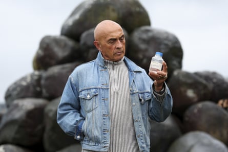
Ray Ahipene-Mercer, 78, who led a 16-year campaign to get the treatment plant built throughout the 80s, said he felt gutted. Before 1998, the ocean smelled and looked terrible, with visible excrement on the rocks and surfers routinely emerging with ear infections and gastroenteritis.
“I thought it was all done, and here we are back to where we were 30 years ago,” Ahipene-Mercer, of Ngāi Tara descent, said. “It’s a catastrophe.”
On 4 February, an overnight electrical failure flooded the Moa Point wastewater treatment plant, destroying 80% of the equipment. Initially, raw sewage was being pumped directly out of a five-metre pipe near a beach at Tarakena Bay. Now, most sewage is being sent 1.8km offshore in the Cook Strait, after being screened for large objects such as tampons and wet wipes.
Water management has long been a contentious issue in New Zealand, with legislation to centralise its control and overhaul outdated services thrown out by the National-led coalition government in favour of local reforms in early 2024.
In Wellington, ageing pipes have caused issues with wastewater and stormwater flooding. The Moa Point plant is owned and overseen by two layers of local government and a council-owned water utility – Wellington Water – who contract the French-owned waste management company Veolia to run the plant.
“It looked convoluted to me, and it wasn’t clear where actual authority lay,” the Wellington mayor, Andrew Little, who has been in the job four months, told the Guardian, adding that Wellingtonians were in a “state of shock”.
A crown inquiry called by the local government minister, Simon Watts, will look into the causes of the disaster. “The public is owed the assurance that we understand what led to this failure and that we are taking steps to prevent it from happening again,” Watts told Radio New Zealand.
He said that as part of the coalition government’s water reforms, a new entity, Tiaki Wai, would take over from Wellington Water in July, which he expected to improve services. Councils were responsible for underinvesting in water infrastructure, and new legislation would address this, he said.
Little said he could not speculate on the causes due to the inquiry. Wellington Water did not respond to specific questions by deadline, and has said it could not comment publicly due to the ongoing inquiry. Veolia also declined to comment.
Wellington Water chair Pat Dougherty previously told Radio New Zealand there had been underinvestment over a long period at Moa Point, and he backed an investigation. “I worry that there may have been some early warning signs that there were troubles with the discharge and we missed those. But everything needs to be on the table.”
But for many, this is cold comfort. Locals say lower-level pollution has already marred the short Wellington summer, with recurring sewage discharges pointing to a deeper issue at the plant. Official reports showcontinuing issues and warnings about underfunding for years, and the authorities have said a fix could still be months away.
“We are looking at generations of negligence, at a time where our climate is changing dramatically,” said Tamatha Paul, the Green party MP for Wellington Central and former city councillor who called this week’s meeting.
“The way this will affect really vulnerable, delicate species that are already endangered, the fact their entire habitat is being devastated is heartbreaking.”
Central government help is crucial, she said.
Local iwi [tribes] have long opposed any wastewater going into the ocean, Taranaki Whanui chair Te Whatanui Winiata said. “This is our source of sustenance, we are relations to the moana [ocean]. We have been crying about this from the start, saying this kind of sewage system just causes havoc. The response from our people is outrage, shock, and anguish.”
As beaches remain closed and businesses report losses, the Victoria University marine biologist Christopher Cornwall said “huge numbers” of marine creatures who call the various reefs around the south coast home would be suffering the most.
Continued pollution could cause a mass kelp die-off in the Taputeranga Marine Reserve – home to species such as mussels, kina, pāua, sea sponges, fish, crayfish, octopus and penguins – killing their homes and food sources, he said.

Human-borne bacteria and viruses could make these sea creatures sick, along with accumulating in shellfish, making them unsafe to eat. Microplastics get into the stomachs of seabirds and penguins who eat human waste, making them think they are full so that they die of starvation.
The Department of Conservation has said the extent of the damage is not yet known, but would be affected by the length and volume of discharge, ocean currents and wind.
New Zealanders needed to rethink why wastewater was going into oceans in the first place, Cornwall said. “I have no idea why you’d put a pipe in between two reefs anyway, and now all those fecal materials are just getting swept right in. Why are we pumping sewage out on to a kelp forest? It’s clearly not OK, and we should never have been in this situation.”
It’s a feeling shared by many. From her home in Island Bay, Kayla Henderson often watches dolphins playing in Taputeranga reserve. Outside the meeting this week, the young ocean lover felt helpless.
“I just care about the environment,” she said. “And I want to have faith that we won’t have raw sewage and rubbish going into protected marine waterways. I didn’t think it would be that hard.”
CLICK HERE FOR MORE INFORMATION
https://www.theguardian.com/world/2026/feb/19/wellington-raw-sewage-leak-spill-water-new-zealand