Ocean heatwaves are breaking Earth’s hidden climate engine

Marine heatwaves are clogging the ocean’s carbon pump, threatening its power to fight climate change.

Source:Monterey Bay Aquarium Research Institute

Summary:Marine heatwaves can jam the ocean’s natural carbon conveyor belt, preventing carbon from reaching the deep sea. Researchers studying two major heatwaves in the Gulf of Alaska found that plankton shifts caused carbon to build up near the surface instead of sinking. This disrupted the ocean’s ability to store carbon for millennia and intensified climate feedbacks. The study highlights the urgent need for continuous, collaborative ocean observation.Share:


FULL STORY


Ocean Heatwaves Break Earth’s Climate Engine
Robotic floats can continuously collect detailed data about ocean conditions. A new study led by MBARI researchers from the Global Ocean Biogeochemistry Array project—with an interdisciplinary team of collaborators—has analyzed data from floats deployed in the Gulf of Alaska and records from ship-based plankton surveys and revealed that marine heatwaves reshape ocean food webs and affect the ocean’s ability to store carbon. Credit: © 2022 MBARI

New research shows that marine heatwaves can reshape ocean food webs, which in turn can slow the transport of carbon to the deep sea and hamper the ocean’s ability to buffer against climate change. The study, published in the scientific journal Nature Communications on October 6, was conducted by an interdisciplinary team of researchers from MBARI, the University of Miami Rosenstiel School of Marine, Atmospheric, and Earth Science, the Hakai Institute, Xiamen University, the University of British Columbia, the University of Southern Denmark, and Fisheries and Oceans Canada.

To explore the impacts of marine heatwaves on ocean food webs and carbon flows, the research team combined multiple datasets that tracked biological conditions in the water column in the Gulf of Alaska for more than a decade. This region experienced two successive marine heatwaves during this time, one from 2013 to 2015 known as “The Blob,” and another from 2019 to 2020.

“The ocean has a biological carbon pump, which normally acts like a conveyor belt carrying carbon from the surface to the deep ocean. This process is powered by the microscopic organisms that form the base of the ocean food web, including bacteria and plankton,” said the lead author, Mariana Bif, previously a research specialist at MBARI and now an assistant professor in the Department of Ocean Sciences at the Rosenstiel School. “For this study, we wanted to track how marine heatwaves affected those microscopic organisms to see if those impacts were connected to the amount of carbon being produced and exported to the deep ocean.”

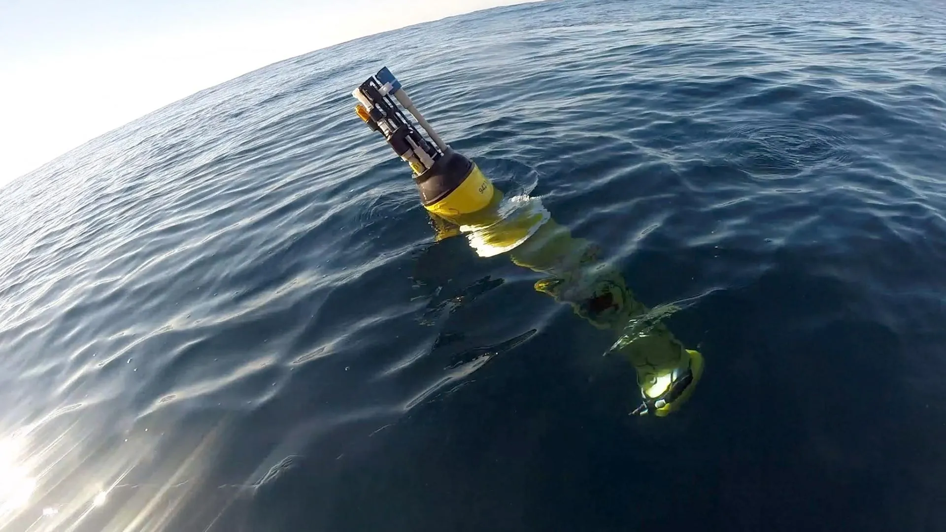
The research team used information collected by the Global Ocean Biogeochemical (GO-BGC) Array, a collaborative initiative funded by the US National Science Foundation and led by MBARI that uses robotic floats to monitor ocean health. The GO-BGC project has deployed hundreds of autonomous biogeochemical Argo (BGC-Argo) floats, which measure ocean conditions such as temperature, salinity, nitrate, oxygen, chlorophyll, and particulate organic carbon (POC) up and down the water column every five to 10 days. The team also looked at seasonal data from ship-based surveys that tracked plankton community composition, including pigment chemistry and sequencing of the environmental DNA (eDNA) from seawater samples collected during the Line P program carried out by Fisheries and Oceans Canada.

The study found that marine heatwaves did impact the base of the ocean food web, and those impacts were connected to changes in the ways that carbon was cycled in the water column. However, the changes that occurred in the food web were not consistent across the two heatwaves.

Under typical conditions, plant-like phytoplankton convert carbon dioxide to organic material. These microorganisms are the foundation of the ocean food web. When they are eaten by larger animals and excreted as waste, they transform into organic carbon particles that sink from the surface through the ocean’s mesopelagic, or twilight, zone (200 to 1,000 meters, approximately 660 to 3,300 feet) and down to the deep sea. This process locks atmospheric carbon away in the ocean for thousands of years.

During the 2013-2015 heatwave, surface carbon production by photosynthetic plankton was high in the second year, but rather than sinking rapidly to the deep sea, small carbon particles piled up approximately 200 meters (roughly 660 feet) underwater.

During the 2019-2020 heatwave, there was record-high accumulation of carbon particles at the surface in the first year that could not be attributed to carbon production by phytoplankton alone. Instead, this accumulation was likely due to the recycling of carbon by marine life and the buildup of detritus waste. This pulse of carbon then sank to the twilight zone, but lingered at depths of 200 to 400 meters (roughly 660 to 1,320 feet) instead of sinking to the deep sea.

The team attributed these differences in carbon transport between the two heatwaves to changes in phytoplankton populations. These changes cascaded through the food web, leading to a rise in small grazers who do not produce fast-sinking waste particles, so carbon was retained and recycled at the surface and in the upper twilight zone rather than sinking to deeper depths.

“Our research found that these two major marine heatwaves altered plankton communities and disrupted the ocean’s biological carbon pump. The conveyor belt carrying carbon from the surface to the deep sea jammed, increasing the risk that carbon can return to the atmosphere instead of being locked away deep in the ocean,” said Bif.

This research demonstrated that not all marine heatwaves are the same. Different plankton lineages rise and fall during these warming events, underscoring the need for long-term, coordinated monitoring of the ocean’s biological and chemical conditions to accurately model the diverse, and expansive, ecological impacts of marine heatwaves.

“This research marks an exciting new chapter in ocean monitoring. To really understand how a heatwave impacts marine ecosystems and ocean processes, we need observation data from before, during, and after the event. This research included robotic floats, pigment chemistry, and genetic sequencing, all working together to tell the entire story. It’s a great example of how collaboration can help us answer key questions about the health of the ocean,” said MBARI Senior Scientist Ken Johnson, the lead principal investigator for the GO-BGC project and a coauthor of the study.

Ocean observations and models suggest that marine heatwaves have been expanding in size and intensifying over the past few decades. The ocean absorbs a quarter of the carbon dioxide emitted each year, thanks to the steady stream of carbon particles sinking from the surface to the deep sea. A warmer ocean can mean less carbon locked away, which in turn can accelerate climate change. Beyond the changes to carbon transport, the shifts in plankton at the foundation of the ocean food web have cascading impacts on marine life and human industry too.

“Climate change is contributing to more frequent and intense marine heatwaves, which underscores the need for sustained, long-term ocean monitoring to understand and predict how future marine heatwaves will impact ecosystems, fisheries, and climate,” said Bif.

This work was funded by the US National Science Foundation’s GO-BGC project (NSF Award 1946578 with operational support from NSF Award 2110258), with additional support from the David and Lucile Packard Foundation, China National Science Foundation (grant number: 42406099), Fundamental Research Funds for the Central Universities (grant number: 20720240105), Danish Center for Hadal Research (Grant No. DNRF145), and Fisheries and Oceans Line P program.

CLICK HERE FOR MORE INFORMATION

https://www.sciencedaily.com/releases/2025/10/251007081819.htm

Local News

Northfield, Minnesota warns residents of unsafe drinking water for infants

By Jason Rantala

In 2019, city officials in Northfield, Minnesota said the town’s water supply tested for high levels of manganese.

In high doses, the metal can cause memory, attention and motor skills problems for adults, and particularly impacts infants, according to the Minnesota Department of Health.

Earlier this year, the city scrapped plans to build a new water treatment facility because costs became too high, rising from $60 million to $83 million.

“Certainly we’re all committed to safe and healthy drinking water here in Northfield,” said Ben Martig, Northfield’s city administrator.

City officials are now advising families with infants under 1 to have them drink bottled water or to treat the water themselves, like with a reverse osmosis system.

Officials said they have been warning residents about the water quality issues for years through multiple press releases.

“We’ve talked with local providers, letting them know to notify pregnant mothers and newborn families that they should be looking at different options for their water and making sure that it is further treated,” said Justin Wagner, the city’s utilities manager.

“It’s unsafe for children under 1 and people who are pregnant, and those are important and valuable people to our community, too,” said Ward 1 City Council Member Kathleen Holmes.

She said water treatment is a city need, and costs for the project will only increase as time passes.

“This is a situation for renters who can’t put in reverse osmosis or can’t afford it,” said Holmes.

Northfield resident Levi Prinzing is the parent of an infant, but said at this point he’s more worried about the financial impacts of a new treatment facility. Prinzing also filters his water.

“I don’t think we need a new treatment plant,” said Prinzing. “The treatment plant is a lot of money and we just raised our taxes a lot.”

“We have to find a way to work together as a council and find a solution that can help bridge that gap, that we can provide safe drinking water for all residents, and hopefully reduce the financial impact or financial burden that it is on residents,” said Holmes.

The City Council may reconsider the water treatment facility in June.

CLICK HERE FOR MORE INFORMATION

https://www.cbsnews.com/minnesota/news/northfield-minnesotas-warns-residents-of-unsafe-drinking-water-for-infants/?intcid=CNM-00-10abd1h

The shocking reason Arctic rivers are turning rusty orange

Ice doesn’t just freeze, it fuels hidden chemistry that could turn rivers rusty as the planet warms.

Source:Umea University

Summary:Researchers found that ice can trigger stronger chemical reactions than liquid water, dissolving iron minerals in extreme cold. Freeze-thaw cycles amplify the effect, releasing iron into rivers and soils. With climate change accelerating these cycles, Arctic waterways may face major transformations.


FULL STORY


Why Arctic Rivers Are Turning Rusty Orange
An aerial view of the rust-colored Kutuk River in Gates of the Arctic National Park in Alaska. Thawing permafrost is exposing minerals to weathering, increasing the acidity of the water, which releases metals like iron, zinc, and copper. Credit: Ken Hill / National Park Service

Ice can dissolve iron minerals more effectively than liquid water, according to a new study from Umeå University. The discovery could help explain why many Arctic rivers are now turning rusty orange as permafrost thaws in a warming climate.

The study, recently published in the scientific journal PNAS, shows that ice at minus ten degrees Celsius releases more iron from common minerals than liquid water at four degrees Celsius. This challenges the long-held belief that frozen environments slow down chemical reactions.

“It may sound counterintuitive, but ice is not a passive frozen block,” says Jean-François Boily, Professor at Umeå University and co-author of the study. “Freezing creates microscopic pockets of liquid water between ice crystals. These act like chemical reactors, where compounds become concentrated and extremely acidic. This means they can react with iron minerals even at temperatures as low as minus 30 degrees Celsius.”

To understand the process, the researchers studied goethite – a widespread iron oxide mineral – together with a naturally occurring organic acid, using advanced microscopy and experiments.

They discovered that repeated freeze-thaw cycles make iron dissolve more efficiently. As the ice freezes and thaws, organic compounds that were previously trapped in the ice are released, fuelling further chemical reactions. Salinity also plays a crucial role: fresh and brackish water increase dissolution, while seawater can suppress it.

The findings apply mainly to acidic environments, such as mine drainage sites, frozen dust in the atmosphere, acid sulfate soils along the Baltic Sea coast, or in any acidic frozen environment where iron minerals interact with organics. The next step is to find out if the same is true for all iron-bearing ice. This is what ongoing research in the Boily laboratory will soon reveal.

“As the climate warms, freeze-thaw cycles become more frequent,” says Angelo Pio Sebaaly, doctoral student and first author of the study. “Each cycle releases iron from soils and permafrost into the water. This can affect water quality and aquatic ecosystems across vast areas.”

The findings show that ice is not a passive storage medium, but an active player. As freezing and thawing increase in polar and mountain regions, for the impact on ecosystems. and the natural cycling of elements could be significant.

CLICK HERE FOR MORE INFORMATION

https://www.sciencedaily.com/releases/2025/09/250922074938.htm

Number of people suffering extreme droughts will double

Source:Michigan State University

Summary:A global research effort offers the first worldwide view of how climate change could affect water availability and drought severity in the decades to come. By the late 21st century, global land area and population facing extreme droughts could more than double — increasing from 3% during 1976-2005 to 7%-8%, according to a professor of civil and environmental engineering.Share:


FULL STORY


Michigan State University is leading a global research effort to offer the first worldwide view of how climate change could affect water availability and drought severity in the decades to come.

By the late 21st century, global land area and population facing extreme droughts could more than double — increasing from 3% during 1976-2005 to 7%-8%, according to Yadu Pokhrel, associate professor of civil and environmental engineering in MSU’s College of Engineering, and lead author of the research published in Nature Climate Change.

“More and more people will suffer from extreme droughts if a medium-to-high level of global warming continues and water management is maintained at its present state,” Pokhrel said. “Areas of the Southern Hemisphere, where water scarcity is already a problem, will be disproportionately affected. We predict this increase in water scarcity will affect food security and escalate human migration and conflict.”

The research team, including MSU postdoctoral researcher Farshid Felfelani, and more than 20 contributing authors from Europe, China and Japan are projecting a large reduction in natural land water storage in two-thirds of the world, also caused by climate change.

Land water storage, technically known as terrestrial water storage, or TWS, is the accumulation of water in snow and ice, rivers, lakes and reservoirs, wetlands, soil and groundwater — all critical components of the world’s water and energy supply. TWS modulates the flow of water within the hydrological cycle and determines water availability as well as drought.

“Our findings are a concern,” Pokhrel said. “To date, no study has examined how climate change would impact land water storage globally. Our study presents the first, comprehensive picture of how global warming and socioeconomic changes will affect land water storage and what that will mean for droughts until the end of the century.”

Felfelani said the study has given the international team an important prediction opportunity.

“Recent advances in process-based hydrological modeling, combined with future projections from global climate models under wide-ranging scenarios of socioeconomic change, provided a unique foundation for comprehensive analysis of future water availability and droughts,” Felfelani said. “We have high confidence in our results because we use dozens of models and they agree on the projected changes.”

The research is based on a set of 27 global climate-hydrological model simulations spanning 125 years and was conducted under a global modeling project called the Inter-Sectoral Impact Model Intercomparison Project. Pokhrel is a working member of the project.

“Our findings highlight why we need climate change mitigation to avoid the adverse impacts on global water supplies and increased droughts we know about now,” Pokhrel said. “We need to commit to improved water resource management and adaptation to avoid potentially catastrophic socio-economic consequences of water shortages around the world.”

CLICK HERE FOR MORE INFORMATION

https://www.sciencedaily.com/releases/2021/01/210111125605.htm

Climate changes lead to water imbalance, conflict in Tibetan Plateau

Melting glaciers are putting a hold on countries’ development

Source:Ohio State University

Summary:Climate change is putting an enormous strain on global water resources, and according to researchers, the Tibetan Plateau is suffering from a water imbalance so extreme that it could lead to an increase in international conflicts.Share:


FULL STORY


Climate change is putting an enormous strain on global water resources, and according to researchers, the Tibetan Plateau is suffering from a water imbalance so extreme that it could lead to an increase in international conflicts.

Nicknamed “The Third Pole,” the Tibetan Plateau and neighboring Himalayas is home to the largest global store of frozen water outside of the North and South Polar Regions. This region, also known as the Asian water tower (AWT), functions as a complex water distribution system which delivers life-giving liquid to multiple countries, including parts of China, India, Nepal, Pakistan, Afghanistan, Tajikistan and Kyrgyzstan.

Yet due to the rapid melting of snow and upstream glaciers, the area can’t sustainably support the continued growth of the developing nations that rely on it.

“Populations are growing so rapidly, and so is the water demand,” said Lonnie Thompson, distinguished university professor of earth sciences at The Ohio State University and senior research scientist at the Byrd Polar Research Center. “These problems can lead to increased risks of international and even intranational disputes, and in the past, they have.”

Thompson, who has studied climate change for nearly five decades, is intimately familiar with the precarious nature of the region’s hydrological situation. In 1984, Thompson became a member of the first Western team sent to investigate the glaciers in China and Tibet. Since then, he and a team of international colleagues have spent years investigating ice core-derived climate records and the area’s rapidly receding ice along with the impact it’s had on the local settlements that depend on the AWT for their freshwater needs.

The team’s latest paper, of which Thompson is a co-author, was published in the journal Nature Reviews Earth and Environment. Using temperature change data from 1980 to 2018 to track regional warming, their findings revealed that the AWT’s overall temperature has increased at about 0.42 degrees Celsius per decade, about twice the global average rate.

“This has huge implications for the glaciers, particularly those in the Himalayas,” Thompson said. “Overall, we’re losing water off the plateau, about 50% more water than we’re gaining.” This scarcity is causing an alarming water imbalance: Northern parts of Tibet often experience an overabundance of water resources as more precipitation occurs due to the strengthening westerlies, while southern river basins and water supplies shrink as drought and rising temperatures contribute to water loss downstream.

According to the study, because many vulnerable societies border these downstream basins, this worsening disparity could heighten conflicts or exacerbate already tense situations between countries that share these river basins, like the long-term irrigation and water struggles between India and Pakistan.

“The way that regional climate varies, there are winners and losers,” Thompson said. “But we have to learn to work together in order to ensure adequate and equitable water supplies throughout this region.” As local temperatures continue to rise and water resources become depleted, more people will end up facing ever diminishing water supplies, he said.

Still, overall increases in precipitation alone won’t meet the increased water demands of downstream regions and countries.

To combat this, the study recommends using more comprehensive water monitoring systems in data-scarce areas, noting that better atmospheric and hydrologic models are needed to help predict what’s happening to the region’s water supply. Lawmakers should then use those observations to help develop actionable policies for sustainable water management, Thompson said. If policymakers do decide to listen to the scientists’ counsel, these new policies could be used to develop adaptation measures for the AWT through collaboration between upstream and downstream countries.

After all, when things go awry in one area of the world, like the butterfly effect, they tend to have long-lasting effects on the rest of Earth’s population. “Climate change is a global process,” Thompson said. “It doesn’t matter what country or what part of the world you come from. Sooner or later, you’ll have a similar problem.”

CLICK HERE FOR MORE INFORMATION

https://www.sciencedaily.com/releases/2022/06/220623140114.htm

Gulf corals still suffering more than a decade after Deepwater Horizon oil spill, scientists report

Exposure to oil — and possibly the chemicals used to clean up oil spills — has made corals prone to breaking and showing signs of high stress, even today

Source:American Geophysical Union

Summary:Deep-water corals in the Gulf of Mexico are still struggling to recover from the devastating Deepwater Horizon oil spill in 2010, scientists report at the Ocean Science Meeting in New Orleans. Comparing images of more than 300 corals over 13 years — the longest time series of deep-sea corals to date — reveals that in some areas, coral health continues to decline to this day.Share:


FULL STORY


Deep-water corals in the Gulf of Mexico are still struggling to recover from the devastating Deepwater Horizon oil spill in 2010, scientists report at the Ocean Sciences Meeting in New Orleans. Comparing images of more than 300 corals over 13 years — the longest time series of deep-sea corals to date — reveals that in some areas, coral health continues to decline to this day.

The spill slathered hundreds of miles of shoreline in oil, and a slick the size of Virginia coated the ocean surface. Over 87 days, 134 million gallons of oil spilled directly from the wellhead at a depth of 1520 meters (nearly 5000 feet) into the Gulf. While the spill was most visible at the surface, negative ecological impacts extended hundreds of meters into the ocean.

In a presentation on Tuesday, 20 February, scientists will show that deep-water corals remain damaged long after the spill. Over 13 years, these coral communities have had limited recovery — some even continuing to decline.

“We always knew that deep-sea organisms take a long time to recover, but this study really shows it,” said Fanny Girard, a marine biologist and conservationist at the University of Hawai’i at Mānoa who led the work. “Although in some cases coral health appeared to have improved, it was shocking to see that the most heavily impacted individuals are still struggling, and even deteriorating, a decade later.”

The findings can help guide deep-water restoration efforts following oil spills.

Delicate and damaged 

A few months after the Deepwater Horizon well was capped, an interdisciplinary team of researchers surveyed the ocean floor 6 to 22 kilometers (3.7 to 13.7 miles) from the wellhead to record the damage. About 7 miles away and at 1,370 meters (4,495 feet) depth, they found a dense forest of tree-like Paramuricea corals that looked sickly.

“These corals were covered in a brown material,” Girard said. Testing showed the sludge contained traces of a combination of oil and chemical dispersants. A few months later, the researchers found two additional coral sites at 1,580 meters and 1,875 meters (4921 and 6233 feet, respectively) deep that were similarly damaged.

Deep-sea corals are suspension feeders and may have ingested contaminated particles, leading to the observed health impacts, the researchers said. Direct exposure to toxic chemicals contained in the mixture of oil and chemicals may have also damaged coral tissue. However, to date, scientists still do not exactly know how the oil and dispersant affected these vulnerable organisms.

Every year from 2010 to 2017, scientists visited those three sites to monitor damages, measure growth rates and note any recovery of the corals, as part of a large initiative aiming to better understand ecosystem impacts and improve our ability to respond to future oil spills. They used a remotely operated vehicle to take high-resolution photographs of corals at all three impacted sites and two far-removed reference sites, tracking more than 300 corals overall.

The researchers visited these sites again in 2022 and 2023 as part of the Habitat Assessment and Evaluation project, one of the projects funded through the Natural Resource Damage Assessment settlement. The images allowed the team to measure changes to coral health over time, including noting any breaks along the delicate branches of the coral caused by exposure to oil pollution.

Still suffering after all these years

The scientists found that even by 2022, the affected corals continued to show signs of stress and damage from the oil spill. The brown coating they had first observed was long gone, but upon closer inspection, the corals were weak and prone to breaking. The scarred spots where branches fell off were leaking mucus, and some corals whose skeletons were exposed had been colonized by other, parasitic coral species.

“Not only were some of these corals not recovering, but some of them seemed to be getting worse,” Girard said. She added that if the impacts are too heavy, ecosystems can struggle to recover at all, especially given the onslaught of climate change-related stressors like ocean acidification. “It’s really important to prevent damage in the first place, and the way to do that is through protection measures.”

Girard notes that their work is being used to inform restoration strategies, including trying to grow deep-sea corals for coral propagation from transplants, deploying artificial anchoring sites for recolonization or protecting the deepwater communities and letting nature heal itself. In the coming years, the team will continue to monitor to corals, looking for signs that they’re getting better — or worse.

CLICK HERE FOR MORE INFORMATION

https://www.sciencedaily.com/releases/2024/02/240220144632.htm

Hungry flathead catfish are changing everything in the Susquehanna

New study suggests that smallmouth bass and channel catfish are changing what they eat to avoid having to compete with or being eaten by the invader.

Source:Penn State

Summary: Flathead catfish are rapidly reshaping the Susquehanna River’s ecosystem. Once introduced, these voracious predators climbed to the top of the food chain, forcing native fish like channel catfish and bass to shift diets and habitats. Using stable isotope analysis, researchers uncovered how the invaders disrupt food webs, broaden dietary overlaps, and destabilize energy flow across the river system. The findings show how a single invasive species can spark cascading ecological consequences. Share:


FULL STORY


Flathead Catfish Take Over the Susquehanna
Flatheads grow fast in this river system, attain large body sizes and can eat a variety of prey. Because adult flatheads have few natural predators, they can exert strong control over the ecosystem. Credit: Penn State

Flathead catfish, opportunistic predators native to the Mississippi River basin, have the potential to decimate native and recreational fisheries, disrupting ecosystems in rivers where they become established after their introduction or invasion from a nearby river drainage. That concern led a team of researchers from Penn State, the U.S. Geological Survey (USGS), and the Pennsylvania Fish and Boat Commission to assess how flatheads are affecting the food web and energy flow in the Susquehanna River in Pennsylvania, where they were first detected in 1991. Their population has grown rapidly in the decades since.

“Flatheads grow fast in this river system, attain large body sizes and can eat a variety of prey,” said study first author Olivia Hodgson, a master’s degree student in Penn State’s Intercollege Graduate Degree Program in Ecology. “Because adult flatheads have few natural predators, flathead catfish can exert strong control over the ecosystem.”

Hodgson is working with Tyler Wagner, a scientist with the USGS Pennsylvania Cooperative Fish and Wildlife Research Unit Program and a Penn State affiliate professor of fisheries ecology. He is senior author on the study. In findings published Sept. 4 in Ecology, the researchers reported that flathead catfish are apex predators.

Flatheads had the highest trophic position — the level an organism occupies in a food web, based on its feeding relationships — even higher than resident top predators such as smallmouth bass and channel catfish. Channel catfish had a lower trophic position in areas with flathead catfish. This means they now eat lower on the food chain, likely because they are being outcompeted by flatheads or avoiding them, the researchers explained. In areas with flathead catfish, they found, all species showed broader and overlapping diets.

“This suggests that resident species are changing what they eat to avoid competing with or being eaten by the invader,” Hodgson said. “These findings support the ‘trophic disruption hypothesis,’ that says when a new predator enters an ecosystem, it forces existing species to alter their behavior, diets and roles in the food web. This can destabilize ecosystems over time. Our study highlights how an invasive species can do more than just reduce native populations — it can reshape entire foodwebs and change how energy moves through ecosystems.”

Although the predatory effects of invasive catfishes on native fish communities have been documented — such as in a recent study on the Susquehanna River led by researchers at Penn State — the impacts of invasion on riverine food webs are poorly understood, Hodgson noted. This study quantified the effects of invasive flathead catfish on the food web in the Susquehanna by comparing uninvaded river sections to invaded sections, focusing on several key species: flathead catfish — invader, channel catfish and smallmouth bass — resident predators, and crayfish and minnows — prey.

In addition to evaluating trophic position, the researchers analyzed the isotopic niche occupied by the fish species — the range of carbon and nitrogen markers found within the tissues of an organism, reflecting its diet and habitat, providing insights into its ecological role.

To reach their conclusions, the researchers employed stable isotope analysis, a widely used tool that can explain patterns within a food web, highlighting links between trophic positions, as well as the breadth and overlap of trophic niches. Stable isotope analysis is especially useful for studying invasion ecology, such as investigating trophic reorganization and trophic overlap between introduced and resident species.

When fish eat, their bodies incorporate the isotopic signature of their food. By sampling their tissues, scientists can measure nitrogen isotopes and determine their diet, carbon isotopes to determine habitat use, and compare isotopic signatures across regions to deduce fish migration or habitat shifts. For this study, channel catfish, smallmouth bass, minnows and crayfish were selected as focal species because a previous diet analysis conducted in collaboration with Penn State, USGS, and Pennsylvania Fish and Boat Commission researchers within the Susquehanna River, showed that these species are important prey for flathead catfish.

The researchers collected a total of 279 fish and 64 crayfish for stable isotope analysis, including 79 flathead catfish, 45 smallmouth bass, 113 channel catfish and 42 minnows comprising nine species. All samples were oven dried and ground to a fine powder using a mortar and pestle. Stable isotope samples were sent to Penn State’s Core Facilities and the Michigan State University Stable Isotope Laboratories for isotope determination.

“Stable isotope analysis explained patterns within the Susquehanna food web in habitats invaded and not invaded by the flathead catfish, and it allowed us to understand links between different species in the river food web and how invasive species might lead to changes in how native species interact and compete, what they eat and how their diets overlap, and if they might be displaced from preferred habitats by the invader,” Hodgson said. “We were able to infer resource use, helping us to better understand potential competition for resources and how this changes when flathead catfish become established.”

Contributing to the research were: Sydney Stark, recent Penn State graduate with a master’s degree in wildlife and fisheries science; Megan Schall, associate professor of biology and science at Penn State Hazleton; Geoffrey Smith, Susquehanna River biologist for the Pennsylvania Fish and Boat Commission; and Kelly Smalling, research hydrologist withtheU.S. Geological Survey, New Jersey Water Science Center.

Funding for this research was provided by Pennsylvania Sea Grant and the U.S. Geological Survey.

CLICK HERE FOR MORE INFORMATION

https://www.sciencedaily.com/releases/2025/09/250909031516.htm

Oceans could reach a dangerous tipping point by 2050

Source:University of California – Santa Barbara

Summary:UC Santa Barbara researchers project that human impacts on oceans will double by 2050, with warming seas and fisheries collapse leading the charge. The tropics and poles face the fastest changes, and coastal regions will be hardest hit, threatening food and livelihoods worldwide.Share:


FULL STORY


Oceans Near Breaking Point by 2050
By 2050, ocean impacts from climate change and overuse could double—unless urgent action is taken. Credit: Shutterstock

The seas have long sustained human life, but a new UC Santa Barbara study shows that rising climate and human pressures are pushing the oceans toward a dangerous threshold.

Vast and powerful, the oceans can seem limitless in their abundance and impervious to disturbances. For millennia, humans have supported their lives, livelihoods and lifestyles with the ocean, relying on its diverse ecosystems for food and material, but also for recreation, business, wellness and tourism.

Yet the future of our oceans is worrying, according to researchers at UCSB’s National Center for Ecological Analysis and Synthesis (NCEAS).

“Our cumulative impact on the oceans, which is already substantial, is going to double by 2050 — in just 25 years,” said marine ecologist and NCEAS director Ben Halpern, who led the effort to forecast the future state of marine environments as they bow under the combined pressures of human activities, which include ocean warming, fisheries biomass loss, sea level rise, acidification and nutrient pollution, among other impacts. “It’s sobering. And it’s unexpected, not because impacts will be increasing — that is not surprising — but because they will be increasing so much, so fast.”

The research team, which includes collaborators from Nelson Mandela University in South Africa, also finds that the tropics and the poles will experience the fastest changes in impacts, and that coastal areas will feel the brunt of the increased impacts.

Their research, supported in large part by the National Science Foundation, is published in the journal Science.

A comprehensive global model of human impacts

As human activity on the ocean and along the coast has intensified, so have impacts on the marine environment. Halpern and a group of scientists first tackled the challenge of understanding how these pieces fit together to affect the ocean nearly 20 years ago, laying the groundwork for the current study.

“People tracked one issue at a time, but not everything together,” Halpern said. “More importantly, there was a pervasive sense that the ocean is so huge the human impacts couldn’t possibly be that bad.”

Their quest to build a comprehensive model of human impacts on the ocean led to a 2008 paper in the journal Science, a landmark study that synthesized 17 global data sets to map the intensity and extent of human activity on the world’s oceans. That initial view revealed startling results: No place was untouched, and 41% of the world’s marine environments were heavily impacted.

“The previous paper tells us where we are; the current paper tells us where we are headed,” Halpern said.

Ocean warming and biomass loss due to fisheries are expected to be the largest overall contributors to future cumulative impacts. Meanwhile, the tropics face rapidly increasing rates of impact, while the poles, which already experience a high level of impact, are expected to experience even more. According to the paper, the high level of future impacts “may exceed the capacity of ecosystems to cope with environmental change,” in turn posing challenges for human societies and institutions in a variety of ways.”

The world’s coasts are expected to bear the brunt of these increasing cumulative impacts — an unsurprising reality, the researchers say, given most human uses of the ocean are near coasts. Yet it’s also a “worrisome result nonetheless,” according to the paper, because the coasts “are where people derive most value from the ocean.” Additionally, many countries are dependent on the ocean for food, livelihood and other benefits. “Many of these countries will face substantial increases,” Halpern said.

The authors contend that enacting policies to reduce climate change and to strengthen fisheries management could be effective ways to manage and reduce human impacts, given the outsize roles that ocean warming and biomass loss play in the estimate of future human impacts on the ocean. Likewise, prioritizing management of habitats that are expected to be heavily impacted — such as salt marshes and mangroves — could help reduce the pressures on them.

In presenting these forecasts and analyses, the researchers hope that effective action can be taken sooner rather than later to minimize or mitigate the effects of increased pressures from human activity.

“Being able to look into the future is a super powerful planning tool,” Halpern said. “We can still alter that future; this paper is a warning, not a prescription.”

Research in this paper was also conducted by Melanie Frazier and Casey C. O’Hara at UCSB, and Alejandra Vargas-Fonseca and Amanda T. Lombard at Nelson Mandela University in South Africa.

CLICK HERE FOR MORE INFORMATION

https://www.sciencedaily.com/releases/2025/09/250905180728.htm

Even the toughest corals are shrinking in warming seas

Resilient coral growth predicted to decrease over next 3 decades, study finds.

Source:Ohio State University

Summary:Scientists found that Red Sea corals can endure warming seas but grow much smaller and weaken under long-term heat stress. Though recovery is possible in cooler months, rising global temperatures may outpace their resilience, endangering reefs and the people who depend on them.Share:


FULL STORY


Even the Toughest Corals Are Shrinking
Resilient Red Sea corals survive extreme heat but shrink and weaken, raising alarms about the future of marine life and reef-dependent communities. Credit: Shutterstock

As coral reefs decline at unprecedented rates, new research has revealed that some coral species may be more resilient to warming temperatures than others.

By studying how six months of elevated ocean temperatures would affect a species of coral from the northern Red Sea called Stylophora pistillata, scientists found that although these organisms can certainly survive in conditions that mimic future warming trends, they don’t thrive.

Stylophora pistillata tend to be tolerant of high ocean temperatures, but when continuously exposed to temperatures of 27.5 and 30 degrees Celsius (81.5 and 86 degrees Fahrenheit) — baseline warming expected in tropical oceans by 2050 and 2100 — scientists saw various changes in coral growth, metabolic rates, and even energy reserves. For instance, coral in 27.5 degrees Celsius waters survived, but were 30% smaller than their control group; those placed in 30 degrees Celsius waters wound up being 70% smaller.

“In theory, if corals in the wild at these temperatures are smaller, reefs might not be as diverse and may not be able to support as much marine life,” said Ann Marie Hulver, lead author of the study and a former graduate student and postdoctoral scholar in earth sciences at The Ohio State University. “This could have adverse effects on people that depend on the reef for tourism, fishing or food.”

Overall, the team’s results suggest that even the most thermally tolerant coral species may suffer in their inability to overcome the consequences of warming seas.

The study was published on September 3 in the journal Science of the Total Environment.

While current predictions for coral reefs are dire, there is some good news. During the first 11 weeks of the experiment, researchers saw that corals were only minimally affected by elevated baseline temperatures. Instead, it was the cumulative impact of chronic high temperatures that compromised coral growth and caused them to experience a higher metabolic demand.

The coral later recovered after being exposed for a month to 25 degree Celsius waters, but had a dark pigmentation compared to corals that were never heated. This discovery implies that despite facing ever longer periods of threat from high ocean temperatures in the summer months, resilient coral like S. pistillata can bounce back when waters cool in the winter, researchers say.

Still, as ocean temperatures are expected to increase by 3 degrees Celsius by 2100, expecting coral reefs to predictably bend to projected climate models can be difficult, according to the researchers.

This team’s research does paint a more detailed picture of how coral reefs may look and function in the next 50 years, said Andrea Grottoli, co-author of the study and a professor in earth sciences at Ohio State.

“Survival is certainly the No. 1 important thing for coral, but when they’re physiologically compromised, they can’t do that forever,” said Grottoli. “So there’s a limit to how long these resilient corals can cope with an ever increasing warming ocean.”

Gaining a more complex understanding of how warming waters can alter coral growth and feeding patterns may also better inform long-term conservation efforts, said Grottoli.

“Conservation efforts could focus on areas where resilient coral are present and create protected sanctuaries so that there are some ecosystems that grow as high-probability-success reefs for the future,” she said.

For now, all coral reefs are still in desperate need of protection, researchers note. To that end, Hulver imagines future work could be aimed at investigating the resilience of similar species of coral, including replicating this experiment to determine if sustained warming might cause trade-offs in other biological processes, such as reproduction.

“For coral, six months is still a very small snapshot of their lives,” said Hulver. “We’ll have to keep on studying them.”

Other Ohio state co-authors include Shannon Dixon and Agustí Muñoz-Garcia as well as Éric Béraud and Christine Ferrier-Pagès from the Centre Scientifique de Monaco, and Aurélie Moya, Rachel Alderdice and Christian R Voolstra from the University of Konstanz. The study was supported by the National Science Foundation and the German Research Foundation.

CLICK HERE FOR MORE INFORMATION

https://www.sciencedaily.com/releases/2025/09/250905112308.htm

Wildfires threaten water quality for up to eight years after they burn

A study of 100,000 water samples from 500 river basins found elevated levels of contaminants persist for years after a fire.

Source:University of Colorado at Boulder

Summary:Wildfires don’t just leave behind scorched earth—they leave a toxic legacy in Western rivers that can linger for nearly a decade. A sweeping new study analyzed over 100,000 water samples from more than 500 U.S. watersheds and revealed that contaminants like nitrogen, phosphorus, organic carbon, and sediment remain elevated for up to eight years after a blaze.Share:


FULL STORY


Wildfires Leave Rivers Polluted for 8 Years
Wildfires leave a hidden trail: rivers tainted by long-lasting pollution. New research shows water contamination can linger up to eight years, with storms often triggering delayed surges of toxic runoff. Credit: Shutterstock

Years after wildfires burn forests and watersheds, the contaminants left behind continue to poison rivers and streams across the Western U.S. — much longer than scientists estimated.

A new study, published on June 23 in Nature Communications Earth & Environment, analyzed water quality in more than 500 watersheds across the Western U.S., and is the first large-scale assessment of post-wildfire quality.

The research was led by scientists from the Cooperative Institute for Research in Environmental Science (CIRES) at the University of Colorado Boulder.

“We were attempting to look at notable trends in post-wildfire water quality across the entire U.S. West, to help inform water management strategies in preparing for wildfire effects,” said Carli Brucker, lead author and former CU Boulder and Western Water Assessment PhD student.

The results showed contaminants like organic carbon, phosphorus, nitrogen, and sediment can degrade water quality for up to eight years after a fire. Water managers can use this data to help them plan for the future and respond appropriately when wildfires strike.

CIRES Fellow and Western Water Assessment Director Ben Livneh was the principal investigator and co-author of the study. Much of his research focuses on hydrology, or water supply, on a continental scale. When he realized he could use the same approach to understand large-scale trends in water quality, he was excited to test the method.

“There’s been a lot of work, for example, in the National Climate Assessment and the International Panel on Climate Change talking about changes in global water supply,” said Livneh, associate professor in the Department of Civil, Environmental and Architectural Engineering. “But those assessments point to this gap in water quality assessments in a continental scale context, whereas people like me in physical hydrology have been thinking about the continental scale challenges for a while.”

Researchers have long known that fire ash and soil destruction contribute to degraded water quality. Yet, past research has largely been limited to state and municipal studies — cities and towns test water quality in local streams and rivers following large fires.

For the new study, the team analyzed more than 100,000 water samples from 500 sites: half from burned river basins and half from unburned. They measured levels of organic carbon, nitrogen, phosphorus, and sediment as well as turbidity, or cloudiness, of each sample.

To understand wildfire-driven impacts, the team built data-driven models to measure how much contaminants changed in each basin before and after wildfires. In the final step, they compiled data to find the average across the burned basins for each pre- and post-wildfire year, and then compared those to the unburned basins.

The results showed watersheds take longer to recover after wildfires than previous studies found. Organic carbon, phosphorus, and turbidity are significantly elevated in the first one to five years post-fire. Nitrogen and sediment show significant increases up to eight years post-fire. Fire-driven impacts were worse in more forested areas.

“It can take two years, up to eight years, for the effect to be fully felt,” Livneh said. “Sometimes it can be a delayed effect, meaning, it’s not all happening right away, or sometimes you need a big enough storm that will mobilize enough of the leftover contaminants.”

Each watershed in the study felt the impacts differently. This is likely tied to where the fire struck — a fire closer to the river would be worse than an upstream fire. Different soils, vegetation, and weather also change the impact in each watershed, making it difficult to plan for the future.

“There’s a huge amount of variability in sedimentation rates,” said Brucker, who now works as a consultant. “Some streams are completely clear of sediment after wildfires, and some have 2000 times the amount of sediment.”

Despite variability across river basins, the study provides concrete numbers that give insight to water managers across the Western U.S. Researchers hope the results provide better direction on informing future planning efforts for increasing wildfire resilience.

“I’m hoping that providing concrete numbers is very impactful to water managers,” Brucker said. “You can’t fund resilience improvements on general concerns alone. Water managers need real numbers for planning, and that’s what we’re providing,” Brucker said.

CLICK HERE FOR MORE INFORMATION

https://www.sciencedaily.com/releases/2025/06/250624044332.htm#google_vignette