By Jessica MacAulay, Scott Hezlep, Madeleine Wright
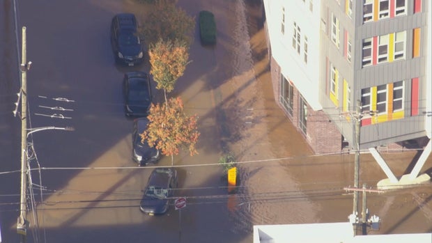
A large water main broke, gushing out 4 million gallons of water into city streets, creating a muddy mess for North Philadelphia residents near Temple University’s campus on Friday.
Chopper 3 was over the water main break at North 9th and West Berks streets shortly after 10 a.m., where crews worked to stop the flow, which took about two hours, officials said. Emergency response crews even used what appeared to be an inflatable raft to navigate the substantially flooded streets Friday morning.
CBS News Philadelphia
The Philadelphia Water Department said the water main is 30 inches wide, and the break was first reported at 8:45 a.m. The department said it was one of the largest breaks they’ve had in a while.
Officials said the water main is from 1879, and when it broke, gallons of water leaked out, flooding city streets. The water main break is just around the block — .2 miles away — from Temple University’s Kardon Atlantic Apartments.
CBS News Philadelphia
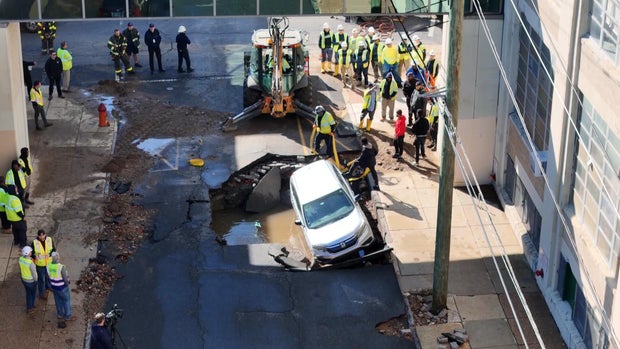
A giant hole was cracked in the ground at the intersection of North 9th Street and Montgomery Avenue. When the main broke, it caused part of the street above it to collapse, damaging a parked car owned by a Temple University chemistry student, Brian Rafferty.
Rafferty said he was getting ready for chemistry class when police called him and said his car was in a watery hole.
“It was, you know, heartbreaking to see, ’cause you know the guys were telling me that it’s probably going to be totaled,” he said.
While the cause of the break is still unknown, Philadelphia’s aging infrastructure has been a challenge for the system.
“We have about 7,000 miles of water mains and sewers altogether, and that is a system that has been built over the course of 200 years, so we are continually replacing those pipes,” Brian Rademaekers, a spokesperson for PWD, said.
CBS News Philadelphia
No one lost water service, but landlord Boris Keisserman said the basement of his rental property flooded.
“Oh, it’s awful. It’s green. Dark green, it’s like I said about 4 feet of the water down there,” he said. “This is a new construction house which I just finished a few months ago. No one lived there. Thank God. I was about to rent it out.”
The city said it plans to reimburse residents whose basements were flooded.
Once crews finish repairing the main, the Streets Department will begin fixing the road, a process expected to take several days.
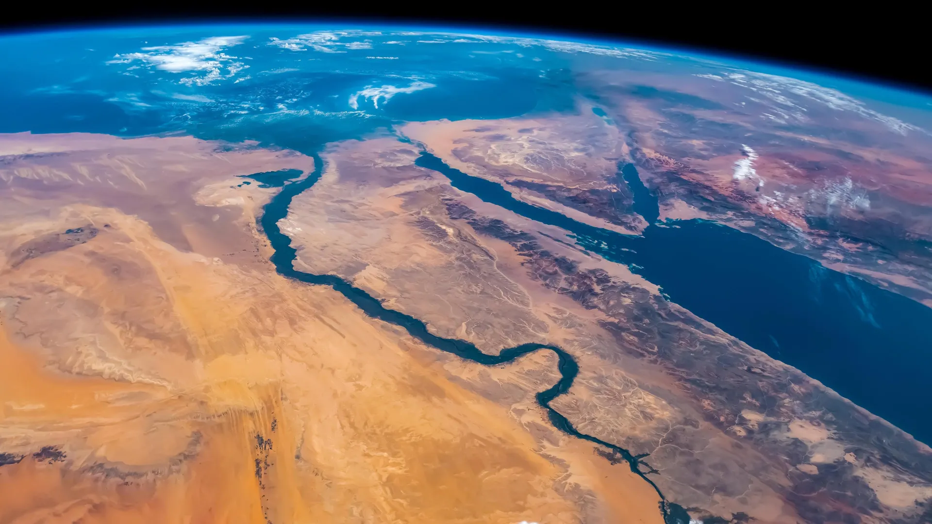
KAUST researchers find the Red Sea experienced a massive disruption 6.2 million years ago completely changing its marine life.
Source:King Abdullah University of Science & Technology (KAUST)
Summary:Researchers at KAUST have confirmed that the Red Sea once vanished entirely, turning into a barren salt desert before being suddenly flooded by waters from the Indian Ocean. The flood carved deep channels and restored marine life in less than 100,000 years. This finding redefines the Red Sea’s role as a key site for studying how oceans form and evolve through extreme geological events.Share:
FULL STORY
Around 6.2 million years ago, the Red Sea completely dried up before a monumental flood from the Indian Ocean refilled it in less than 100,000 years. Credit: Shutterstock
Scientists at King Abdullah University of Science and Technology (KAUST) have provided conclusive evidence that the Red Sea completely dried out about 6.2 million years ago, before being suddenly refilled by a catastrophic flood from the Indian Ocean. The findings put a definitive time on a dramatic event that changed the Red Sea.
Using seismic imaging, microfossil evidence, and geochemical dating techniques, the KAUST researchers showed that a massive change happened in about 100,000 years – a blink of an eye for a major geological event. The Red Sea went from connecting with the Mediterranean Sea to an empty, salt-filled basin. Then, a massive flood burst through volcanic barriers to open the Bab el-Mandab strait and reconnect the Red Sea with the world’s oceans.
“Our findings show that the Red Sea basin records one of the most extreme environmental events on Earth, when it dried out completely and was then suddenly reflooded about 6.2 million years ago,” said lead author Dr. Tihana Pensa of KAUST. “The flood transformed the basin, restored marine conditions, and established the Red Sea’s lasting connection to the Indian Ocean.”
How the Indian Ocean Flooded the Red Sea
The Red Sea was initially connected from the north to the Mediterranean through a shallow sill. This connection was severed, drying the Red Sea into a barren salt desert. In the south of the Red Sea, near the Hanish Islands, a volcanic ridge separated the sea from the Indian Ocean. But around 6.2 million years ago, seawater from the Indian Ocean surged across this barrier in a catastrophic flood. The torrent carved a 320-kilometer-long submarine canyon that is still visible today on the seafloor. The flood rapidly refilled the basin, drowning the salt flats and restoring normal marine conditions in less than 100,000 years. This event happened nearly a million years before the Mediterranean was refilled by the famous Zanclean flood, giving the Red Sea a unique story of rebirth.
Why the Red Sea Matters Geologically
The Red Sea formed by separation of the Arabian Plate from the African Plate beginning 30 million years ago. Initially, the sea was a narrow rift valley filled with lakes, then became a wider gulf when it was flooded from the Mediterranean 23 million years ago. Marine life thrived initially, as seen by the fossil reefs along the northern coast near Duba and Umlujj. However, evaporation and poor seawater circulation increased salinity, causing the extinction of marine life between 15 and 6 million years ago. Additionally, the basin was filled with layers of salt and gypsum. This culminated in complete desiccation of the Red Sea. The catastrophic flood from the Indian Ocean restored marine life in the Red, which persists in the coral reefs to the present.
All in all, the Red Sea is a natural laboratory for understanding how oceans are born, how salt giants accumulate, and how climate and tectonics interact over millions of years. The discovery highlights how closely the Red Sea’s history is linked with global ocean change. It also shows that the region has experienced environmental extremes before, only to return as a thriving marine ecosystem.
“This paper adds to our knowledge about the processes that form and expand oceans on Earth. It also maintains KAUST’s leading position in Red Sea research,” said co-author KAUST Professor Abdulkader Al Afifi.
A dispute over water could jeopardize ongoing construction of what will eventually be the world’s largest lithium mine.
Lithium Americas Corporation filed an emergency motion Monday seeking clarification about whether it needs to stop pumping water to its Thacker Pass lithium mining project in Northern Nevada.
Local rancher Edward Bartell has sued over the project, claiming the company’s water pumping will harm his cattle operation. Nevada’s state engineer had previously found that the company could move forward with its plans to pump water, but a judge partially reversed that finding. Then, last week, the state engineer issued a cease and desist letter to the Canada-based mining company.
In lieu of a legal clarification of the previous decision, Lithium Americas is asking for a limited stay — or temporary suspension — that would allow it to proceed with construction.
“The ruling never mentions … that pumping needs to be halted,” said Tim Crowley, vice president of government and external affairs at Lithium Americas. “We don’t think the judge intended that result.”
Thacker Pass is the largest known lithium resource and reserve in the world. The company needs about 200 acre-feet of water per year during construction, which will continue through 2027. An acre-foot of water is enough to cover roughly a football field with water 1 foot deep or to supply roughly two urban households with indoor and outdoor water needs for a year.
about:blank
Once in production, the company will require about 2,600 acre-feet of water per year.
If the emergency motion is denied, the company said in its filing that it will be “irreparably harmed,” as will the people who are, and plan to be, employed by the company. During construction, the company expects to employ close to 2,000 people.
“We need water to move forward with construction,” Crowley said, noting that construction has been at “full bore” on the $3 billion project since receiving its final investment decision in April, with plans to “go vertical with steel” as soon as August. Construction costs total more than $1 million per day.
The company is asking for the court to issue its decision by July 7, as that’s when the state engineer expects compliance with the cease and desist letter. The company is also working on ways to secure water temporarily, Crowley said, although he declined to provide details.
“We are confident we are not going to have to stop construction,” he said.
Bartell, the rancher who filed the suit that led to the order for the company to stop pumping, told The Nevada Independent in a brief call that “obviously we’re going to challenge (the company’s emergency motion).”
Timeline
Thacker Pass is in a mountainous area northwest of Winnemucca; extraction companies have eyed Thacker Pass since the 1970s, when lithium was found at the site. In 2007, the company that is now Lithium Americas renewed exploration at the site, and in 2020, the company submitted its environmental impact statement to the Bureau of Land Management (BLM).
That same year, Lithium Americas filed an application seeking to move permitted water rights it had previously obtained in the Quinn River Valley closer to the mine site, which sits to the west of the valley.
Bartell protested, claiming the change application would conflict with his existing water rights.
The BLM approved permits for Thacker Pass in 2021 during the final days of President Donald Trump’s first administration, allowing the mining project to move forward, and ultimately, the state engineer granted Lithium America’s request to relocate its water rights, as long as it kept them within the Quinn River Valley.
Lithium Americas adapted to that limitation by constructing an 8-mile-long pipeline to move the water uphill from the valley to the mine site.
In March 2023, Bartell filed a petition for judicial review; the matter didn’t receive an oral hearing until February of this year.
On April 10, the Sixth Judicial District Court of Nevada issued an order reversing the state engineer’s decision on two of the five water rights claims brought forth in the matter, returning them to application status. In the ruling, the court pointed out that the state engineer’s determination that the company’s effects to Bartell’s water rights and cattle operation “is not rooted in scientific fact” because it had “assumed” — rather than scientifically determining — there was enough water in two of the five contested claims.
On April 28, the state engineer issued a letter to Lithium Americas alerting the company that permits for two wells had been returned to application status following the ruling. The state engineer asked the company for additional information that would help “develop a more thorough understanding of the water sources” related to the claims, including data such as flow measurements or pumping test data.
On June 4, staff from the Nevada Division of Water Resources (DWR) found during an investigation of Lithium America’s property that the company was still pumping water.
On June 17, DWR received a letter from Bartell containing photographs showing the company continued to pump water following the June 4 investigation. Meter readings on file with the division confirm that water was pumped from the well since the April ruling.
On June 20, DWR issued a letter to the company stating that “the State Engineer hereby directs LNC to immediately CEASE AND DESIST any further pumping from the Quinn #1 well. The State Engineer likewise hereby notifies LNC that it is prohibited from pumping water from any other well that is proposed as a point of diversion under the above-mentioned applications, including but not limited to the Quinn #2 well.”
Crowley confirmed to The Nevada Independent that the company continues to pump water from the wells while it comes up with an alternative.
“Our interpretation of the cease and desist order is we have 14 days to comply, and no one from the state has suggested that we’re wrong,” Crowley said.
Ongoing legal challenges
The cease and desist order is the latest in a line of legal challenges that has plagued the lithium project.
In 2021, a slew of environmental groups filed a joint lawsuit alleging the BLM violated various federal acts by approving the mine’s environmental impact statement and another suit filed by the Reno-Sparks Indian Colony and other Indigenous people alleged the BLM violated the National Historic Preservation Act.
Bartell also sued, alleging the BLM violated the Endangered Species Act by failing to consider the mine’s effects on Lahontan cutthroat trout and other various environmental concerns.
The suit stood in apparent opposition to a suit he’d filed just two years earlier — not related to the mine — against a project aimed at preserving the trout. In that suit, he objected to the agency’s 2017 decision to allow the Nevada Department of Wildlife to apply rotenone, a type of fish poison, to eradicate non-native brook trout in a portion of Falls Canyon Creek in an effort to restore threatened Lahontan cutthroat trout.
The three suits were dismissed. In 2023, the Reno-Sparks Indian Colony and two other tribes filed a new suit alleging the BLM didn’t consult with them before the project and withheld historical information. That suit also was dismissed.
___
This story was originally published by The Nevada Independent and distributed through a partnership with The Associated Press.
Copyright 2025 The Associated Press. All rights reserved. This material may not be published, broadcast, rewritten or redistributed.
Exposure to oil — and possibly the chemicals used to clean up oil spills — has made corals prone to breaking and showing signs of high stress, even today
Source:American Geophysical Union
Summary:Deep-water corals in the Gulf of Mexico are still struggling to recover from the devastating Deepwater Horizon oil spill in 2010, scientists report at the Ocean Science Meeting in New Orleans. Comparing images of more than 300 corals over 13 years — the longest time series of deep-sea corals to date — reveals that in some areas, coral health continues to decline to this day.Share:
FULL STORY
Deep-water corals in the Gulf of Mexico are still struggling to recover from the devastating Deepwater Horizon oil spill in 2010, scientists report at the Ocean Sciences Meeting in New Orleans. Comparing images of more than 300 corals over 13 years — the longest time series of deep-sea corals to date — reveals that in some areas, coral health continues to decline to this day.
The spill slathered hundreds of miles of shoreline in oil, and a slick the size of Virginia coated the ocean surface. Over 87 days, 134 million gallons of oil spilled directly from the wellhead at a depth of 1520 meters (nearly 5000 feet) into the Gulf. While the spill was most visible at the surface, negative ecological impacts extended hundreds of meters into the ocean.
In a presentation on Tuesday, 20 February, scientists will show that deep-water corals remain damaged long after the spill. Over 13 years, these coral communities have had limited recovery — some even continuing to decline.
“We always knew that deep-sea organisms take a long time to recover, but this study really shows it,” said Fanny Girard, a marine biologist and conservationist at the University of Hawai’i at Mānoa who led the work. “Although in some cases coral health appeared to have improved, it was shocking to see that the most heavily impacted individuals are still struggling, and even deteriorating, a decade later.”
The findings can help guide deep-water restoration efforts following oil spills.
Delicate and damaged
A few months after the Deepwater Horizon well was capped, an interdisciplinary team of researchers surveyed the ocean floor 6 to 22 kilometers (3.7 to 13.7 miles) from the wellhead to record the damage. About 7 miles away and at 1,370 meters (4,495 feet) depth, they found a dense forest of tree-like Paramuricea corals that looked sickly.
“These corals were covered in a brown material,” Girard said. Testing showed the sludge contained traces of a combination of oil and chemical dispersants. A few months later, the researchers found two additional coral sites at 1,580 meters and 1,875 meters (4921 and 6233 feet, respectively) deep that were similarly damaged.
Deep-sea corals are suspension feeders and may have ingested contaminated particles, leading to the observed health impacts, the researchers said. Direct exposure to toxic chemicals contained in the mixture of oil and chemicals may have also damaged coral tissue. However, to date, scientists still do not exactly know how the oil and dispersant affected these vulnerable organisms.
Every year from 2010 to 2017, scientists visited those three sites to monitor damages, measure growth rates and note any recovery of the corals, as part of a large initiative aiming to better understand ecosystem impacts and improve our ability to respond to future oil spills. They used a remotely operated vehicle to take high-resolution photographs of corals at all three impacted sites and two far-removed reference sites, tracking more than 300 corals overall.
The researchers visited these sites again in 2022 and 2023 as part of the Habitat Assessment and Evaluation project, one of the projects funded through the Natural Resource Damage Assessment settlement. The images allowed the team to measure changes to coral health over time, including noting any breaks along the delicate branches of the coral caused by exposure to oil pollution.
Still suffering after all these years
The scientists found that even by 2022, the affected corals continued to show signs of stress and damage from the oil spill. The brown coating they had first observed was long gone, but upon closer inspection, the corals were weak and prone to breaking. The scarred spots where branches fell off were leaking mucus, and some corals whose skeletons were exposed had been colonized by other, parasitic coral species.
“Not only were some of these corals not recovering, but some of them seemed to be getting worse,” Girard said. She added that if the impacts are too heavy, ecosystems can struggle to recover at all, especially given the onslaught of climate change-related stressors like ocean acidification. “It’s really important to prevent damage in the first place, and the way to do that is through protection measures.”
Girard notes that their work is being used to inform restoration strategies, including trying to grow deep-sea corals for coral propagation from transplants, deploying artificial anchoring sites for recolonization or protecting the deepwater communities and letting nature heal itself. In the coming years, the team will continue to monitor to corals, looking for signs that they’re getting better — or worse.
Summary:Stanford researchers reveal meandering rivers existed long before plants, overturning textbook geology. Their findings suggest carbon-rich floodplains shaped climate for billions of years.Share:
FULL STORY
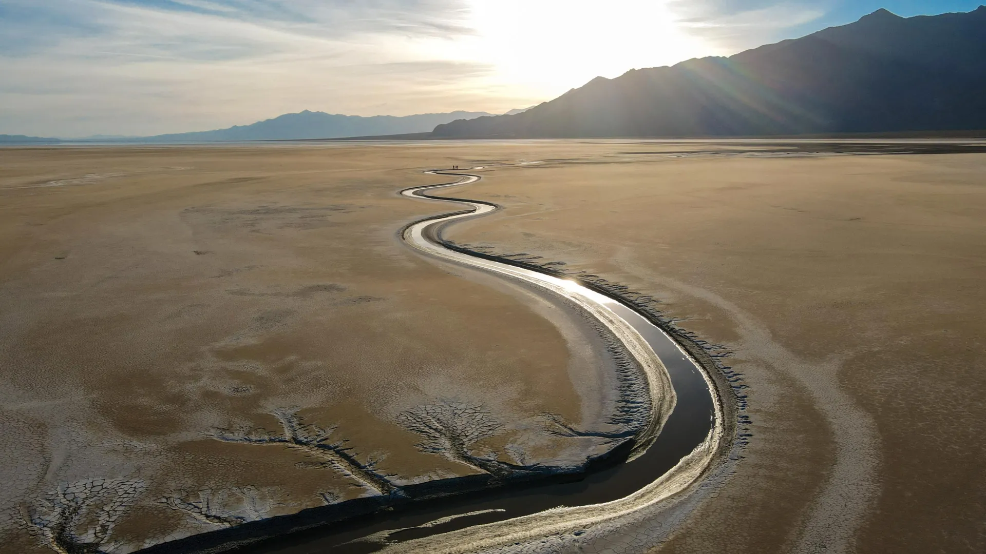
A view of seasonal flow in Shoshone Creek – an unvegetated meandering stream in Nevada. Credit: M. Hasson and M. Lapôtre
A new Stanford study challenges the decades-old view that the rise of land plants half a billion years ago dramatically changed the shapes of rivers.
Rivers generally come in two styles: braided, where multiple channels flow around sandy bars, and meandering, where a single channel cuts S-curves across a landscape. Geologists have long thought that before vegetation, rivers predominantly ran in braided patterns, only forming meandering shapes after plant life took root and stabilized riverbanks.
The new study, which was published online by the journal Science on Aug. 21, 2025, suggests the theory that braided rivers dominated the first 4 billion years of Earth’s history is based on a misinterpretation of the geological record. The research demonstrates that unvegetated meandering rivers can leave sedimentary deposits that look deceptively similar to those of braided rivers. This distinction is crucial for our understanding of Earth’s early ecology and climate, as a river’s type determines how long sediment, carbon, and nutrients are stored in floodplains.
“With our study, we’re pushing back on the widely accepted story of what landscapes looked like when plant life first evolved on land,” said lead author Michael Hasson, a PhD student in Mathieu Lapôtre’s lab at the Stanford Doerr School of Sustainability. “We’re rewriting the story of the intertwined relationship between plants and rivers, which is a significant revision to our understanding of the history of the Earth.”
The muddy floodplains of meandering rivers – dynamic ecosystems created over thousands of years by river overflow – are among the planet’s most abundant non-marine carbon reservoirs. Carbon levels in the atmosphere, in the form of carbon dioxide, act as Earth’s thermostat, regulating temperature over vast timescales. Accurately budgeting for the carbon caches created by meandering rivers could help scientists build more comprehensive models of Earth’s ancient and future climate.
“Floodplains play an important role in determining how, when, and whether carbon is buried or released back into the atmosphere,” Hasson said. “Based on this work, we argue carbon storage in floodplains would have been common for much longer than the classic paradigm that assumes meandering rivers only occurred over the last several hundred million years.”
Where the river flows
To gauge vegetation’s impact on river channel patterns, the researchers examined satellite imagery of about 4,500 bends in 49 current-day meandering rivers. About half of the rivers were unvegetated and half were densely or partly vegetated.
The researchers keyed in on point bars – the sandy landforms that develop on the inside bends of meandering rivers as water flow deposits sediments. Unlike the sandy bars that form in the middle of braided rivers, point bars tend to migrate laterally away from the centers of rivers. Over time, this migration contributes to meandering rivers’ characteristically sinuous channel shapes.
Recognizing that these sandy bars form in different places based on river style, geologists for decades have measured the trajectory of bars in the rock record to reveal ancient river paths. The rocks, typically of sandstones and mudstones, provide evidence for divergent river styles because each deposits different kinds of and amounts of rock-forming sediment, giving geologists clues for reconstructing long-ago river geometries. If sandstones showed little variation in the angle of bar migration, geologists interpreted the bars as moving downstream, and thus that a braided river created the deposits.
Using this technique, geologists had noticed that rivers changed the way they behaved around the time that plants first evolved on Earth. This observation led to the conclusion that land plants made river meandering possible, for instance by trapping sediment and stabilizing riverbanks.
“In our paper, we show that this conclusion – which is taught in all geology curricula to this day – is most likely incorrect,” said Lapôtre, the paper’s senior author and an assistant professor of earth and planetary sciences at the Doerr School of Sustainability.
By looking at modern rivers with a wide range of vegetation cover, the researchers showed that plants consistently change the direction of point bar migration. Specifically, in the absence of vegetation, point bars tend to migrate downstream – like mid-channel bars do in braided rivers.
“In other words, we show that, if one were to use the same criterion geologists use in ancient rocks on modern rivers, meandering rivers would be miscategorized as braided rivers,” Lapôtre said.
Rivers over time
The findings offer a provocative new window into Earth’s past eons, upending the conventional picture of how rivers have sculpted continents. If indeed carbon-loaded floodplains were laid down far more extensively over history, scientists may need to revise models of major natural climate swings over time, with implications for our understanding of ongoing climate change.
“Understanding how our planet is going to respond to human-induced climate change hinges on having an accurate baseline for how it has responded to past perturbations,” Hasson said. “The rock record provides that baseline, but it’s only useful if we interpret it accurately.”
“We’re suggesting that an important control on carbon cycling – where carbon is stored, and for how long, due to river type and floodplain creation – hasn’t been fully understood,” he said. “Our study now points the way to better assessments.”
Additional co-authors are from the University of Padova and the University of British Columbia.
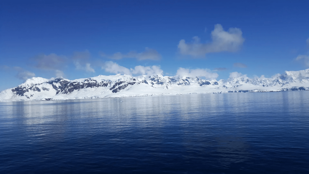
Summary:Deep beneath the Antarctic seas lies a hidden network of 332 colossal submarine canyons, some plunging over 4,000 meters, revealed in unprecedented detail by new high-resolution mapping. These underwater valleys, shaped by glacial forces and powerful sediment flows, play a vital role in transporting nutrients, driving ocean currents, and influencing global climate. Striking differences between East and West Antarctica’s canyon systems offer clues to the continent’s ancient ice history, while also exposing vulnerabilities as warm waters carve away at protective ice shelves.
Submarine canyons are among the most spectacular and fascinating geological formations to be found on our ocean floors, but at an international level scientists have yet to uncover many of their secrets, especially of those located in remote regions of the Earth like the North and South Poles. Now, an article published in the journal Marine Geologyhas brought together the most detailed catalogue to date of Antarctic submarine canyons, identifying a total of 332 canyon networks that in some cases reach depths of over 4,000 meters.
The catalogue, which identifies five times as many canyons as previous studies had, was produced by the researchers David Amblàs, of the Consolidated Research Group on Marine Geosciences at the Faculty of Earth Sciences of the University of Barcelona, and Riccardo Arosio, of the Marine Geosciences Research Group at University College Cork. Their article shows that Antarctic submarine canyons may have a more significant impact than previously thought on ocean circulation, ice-shelf thinning and global climate change, especially in vulnerable areas such as the Amundsen Sea and parts of East Antarctica.Submarine canyons: the differences between East and West Antarctica
The submarine canyons that form valleys carved into the seafloor play a decisive role in ocean dynamics: they transport sediments and nutrients from the coast to deeper areas, they connect shallow and deep waters and they create habitats rich in biodiversity. Scientists have identified some 10,000 submarine canyons worldwide, but because only 27% of the Earth’s seafloor has been mapped in high resolution the real total is likely to be higher. And despite their ecological, oceanographic, and geological value, submarine canyons remain underexplored, especially in polar regions.
“Like those in the Arctic, Antarctic submarine canyons resemble canyons in other parts of the world,” explains David Amblàs. “But they tend to be larger and deeper because of the prolonged action of polar ice and the immense volumes of sediment transported by glaciers to the continental shelf.” Moreover, the Antarctic canyons are mainly formed by turbidity currents, which carry suspended sediments downslope at high speed, eroding the valleys they flow through. In Antarctica, the steep slopes of the submarine terrain combined with the abundance of glacial sediments amplifies the effects of these currents and contributes to the formation of large canyons.The new study by Amblàs and Arosio is based on Version 2 of the International Bathymetric Chart of the Southern Ocean (IBCSO v2), the most complete and detailed map of the seafloor in this region. It uses new high-resolution bathymetric data and a semi-automated method for identifying and analysing canyons that was developed by the authors. In total, it describes 15 morphometric parameters that reveal striking differences between canyons in East and West Antarctica.
“Some of the submarine canyons we analyzed reach depths of over 4,000 meters,” explained David Amblàs. “The most spectacular of these are in East Antarctica, which is characterized by complex, branching canyon systems. The systems often begin with multiple canyon heads near the edge of the continental shelf and converge into a single main channel that descends into the deep ocean, crossing the sharp, steep gradients of the continental slope.”
Riccardo Arosio noted that “It was particularly interesting to see the differences between canyons in the two major Antarctic regions, as this hadn’t been described before. East Antarctic canyons are more complex and branched, often forming extensive canyon-channel systems with typical U-shaped cross sections. This suggests prolonged development under sustained glacial activity and a greater influence of both erosional and depositional sedimentary processes. In contrast, West Antarctic canyons are shorter and steeper, characterized by V-shaped cross sections.”According to David Amblàs, this morphological difference supports the idea that the East Antarctica Ice Sheet originated earlier and has experienced a more prolonged development. “This had been suggested by sedimentary record studies,” Amblàs said, “but it hadn’t yet been described in large-scale seafloor geomorphology.”
About the research, Riccardo Arosio also explained that “Thanks to the high resolution of the new bathymetric database — 500 meters per pixel compared to the 1-2 kilometres per pixel of previous maps — we could apply semi-automated techniques more reliably to identify, profile and analyse submarine canyons. The strength of the study lies in its combination of various techniques that were already used in previous work but that are now integrated into a robust and systematic protocol. We also developed a GIS software script that allows us to calculate a wide range of canyon-specific morphometric parameters in just a few clicks.”
Submarine canyons and climate change
As well as being spectacular geographic accidents, the Antarctic canyons also facilitate water exchange between the deep ocean and the continental shelf, allowing cold, dense water formed near ice shelves to flow into the deep ocean and form what is known as Antarctic Bottom Water, which plays a fundamental role in ocean circulation and global climate.
Additionally, these canyons channel warmer waters such as Circumpolar Deep Water from the open sea toward the coastline. This process is one of the main mechanisms that drives the basal melting and thinning of floating ice shelves, which are themselves critical for maintaining the stability of Antarctica’s interior glaciers. And as Amblàs and Arosio have explained, when the shelves weaken or collapse, continental ice flows more rapidly into the sea and directly contributes to the rise in global sea level.
Amblàs and Arosio’s study also highlights the fact that current ocean circulation models like those used by the Intergovernmental Panel on Climate Change do not accurately reproduce the physical processes that occur at local scales between water masses and complex topographies like canyons. These processes, which include current channeling, vertical mixing and deep-water ventilation, are essential for the formation and transformation of cold, dense water masses like Antarctic Bottom Water. Omitting these local mechanisms limits the ability that models have to predict changes in ocean and climate dynamics.As the two researchers conclude, “That’s why we must continue to gather high-resolution bathymetric data in unmapped areas that will surely reveal new canyons, collect observational data both in situ and via remote sensors and keep improving our climate models to better represent these processes and increase the reliability of projections on climate change impacts.”
Scientists have discovered that melting glaciers could unleash powerful volcanic eruptions by removing the weight that keeps magma trapped deep underground. Antarctica may hold hundreds of these explosive time bombs. Credit: Shutterstock
Melting glaciers may be silently setting the stage for more explosive and frequent volcanic eruptions in the future, according to research on six volcanoes in the Chilean Andes.
Presented today (July 8) at the Goldschmidt Conference in Prague, the study suggests that hundreds of dormant subglacial volcanoes worldwide – particularly in Antarctica – could become more active as climate change accelerates glacier retreat.
The link between retreating glaciers and increased volcanic activity has been known in Iceland since the 1970s, but this is one of the first studies to explore the phenomenon in continental volcanic systems. The findings could help scientists better understand and predict volcanic activity in glacier-covered regions.
Researchers from the University of Wisconsin-Madison, USA, used argon dating and crystal analysis across six volcanoes in southern Chile, including the now dormant Mocho-Choshuenco volcano, to investigate how the Patagonian Ice Sheet’s advance and retreat influenced past volcanic behaviour. The work is in collaboration with researchers from Lehigh University, University of California Los Angeles, and Dickinson College.
By precisely dating previous eruptions and analysing crystals in erupted rocks, the team tracked how the weight and pressure of glacial ice alter the characteristics of magma underground.
They found that during the peak of the last ice age (around 26,000-18,000 years ago), thick ice cover suppressed the volume of eruptions and allowed a large reservoir of silica-rich magma to accumulate 10-15 km below the surface.
As the ice sheet melted rapidly at the end of the last ice age, the sudden loss of weight caused the crust to relax and gasses in the magma to expand. This buildup of pressure triggered explosive volcanic eruptions from the deep reservoir, causing the volcano to form.
Pablo Moreno-Yaeger from the University of Wisconsin-Madison, USA, is presenting the research at the Goldschmidt Conference. He said: “Glaciers tend to suppress the volume of eruptions from the volcanoes beneath them. But as glaciers retreat due to climate change, our findings suggest these volcanoes go on to erupt more frequently and more explosively. The key requirement for increased explosivity is initially having a very thick glacial coverage over a magma chamber, and the trigger point is when these glaciers start to retreat, releasing pressure – which is currently happening in places like Antarctica.
“Our study suggests this phenomenon isn’t limited to Iceland, where increased volcanicity has been observed, but could also occur in Antarctica. Other continental regions, like parts of North America, New Zealand and Russia, also now warrant closer scientific attention.”
While the volcanic response to glacial melting is almost instant in geological terms, the process of changes in the magma system is gradual and occurs over centuries, giving some time for monitoring and early warning.
The researchers also note that increased volcanic activity could have global climate impacts. In the short term, eruptions release aerosol (tiny particles in gases) that can temporarily cool the planet. This was seen after the 1991 eruption of Mount Pinatubo in the Philippines, which reduced global temperatures by approximately 0.5 degrees C. But with multiple eruptions, the effects reverse.
“Over time the cumulative effect of multiple eruptions can contribute to long-term global warming because of a buildup of greenhouse gases,” said Moreno-Yaeger. “This creates a positive feedback loop, where melting glaciers trigger eruptions, and the eruptions in turn could contribute to further warming and melting.”
The research was funded by the National Science Foundation as part of a grant led by Professor Brad Singer at UW-Madison, and is due to be published in a peer-reviewed journal later this year.
The Goldschmidt Conference is the world’s foremost geochemistry conference. It is a joint congress of the European Association of Geochemistry and the Geochemical Society (US), and over 4000 delegates attend. It takes place in Prague, Czech Republic, from July 6-11 2025.