There is urgency for the seven states that rely on the Colorado River to reach an agreement on how to keep water levels high enough in its two major reservoirs. Climate change is threatening water delivery and power systems as the region becomes drier.
Lake Mead, 2022 | Credit: NASA Earth Observatory
The states—Colorado, Utah, Wyoming, New Mexico, Arizona, Nevada, and California—have until next month to agree on alternatives to keep the system afloat for the next couple of decades and submit them to the Bureau of Reclamation. If they don’t, the bureau will propose its own plan for cuts to allocations from the river, which supplies 40 million people and agriculture.
However, there’s a wrinkle in the negotiations. A report released by the bureau on February 8 concluded that 1.3 million acre-feet of water was lost annually to evaporation and transpiration in the three Lower Basin states of Arizona, California, and Nevada. Water lost to evaporation and transpiration has not been considered under the current rules. Despite evaporation and transpiration, the three lower states have continued to draw down from the reservoirs that are threatened by aridification.
Now, all of the Colorado River Basin states, except California, have submitted a letter to the federal government proposing that in times of low water levels, there would be cuts in allocations—most heavily to California—that take evaporation and transpiration into account. The Los Angeles Timesreports that agencies in Southern California would be required to endure the largest cuts, up to 32 percent for evaporation losses if Lake Powell and Lake Mead hit crisis levels. California has proposed a more modest plan that it argues does not rewrite the rules of the river, which are based on historic water rights. Because of the winter snowpack last year, recent storms, and conservation, water levels at Lake Mead, the country’s largest reservoir, are currently about 40 feet higher than was projected.
Added to the federal government’s deadline for the states to come up with a plan for cutbacks, is the fear that a different administration after the November election could change those involved at the federal level.
According to experts, water policy makers and water users in the Colorado River Basin need to get their acts together to substantially cut amounts they take from the river.
At Lees Ferry where river trips, both recreational and scientific, launch. | Credit: public domain
In a new analysis, six experts—Jack Schmidt, Anne Castle, John Fleck, Eric Kuhn, Kathryn Sorensen, and Katherine Tara—released a report saying that immediate action is needed, especially if this dry year is repeated next year. They estimate that consumptive use will exceed the flow of the river by no less than 3.6 million-acre feet, and the two main reservoirs, Lake Mead and Lake Powell, would absorb the bulk of that shortfall, causing them to be depleted and reduced to dangerous levels. Last winter’s snowpack was miserable, and the forecast for the coming season is for less precipitation and warmer temperatures.
However, leaders in the Upper Basin states of Colorado, Utah, New Mexico, and Wyoming, have been unable to agree with their lower basin neighbors of California, Arizona, and Nevada on how to cut water usage along the river. The two basins have been discussing how to allocate the shortages when the current rules expire next year. The experts who wrote the report are urging the federal government to impose cutbacks along the river, according to the Los Angeles Times.
The animosity between the Upper and Lower Basins appears to have torpedoed the Trump administration’s nomination of Ted Cooke to be the commissioner of the Bureau of Reclamation charged with managing the river. Cooke had been a water manager in Arizona for more than 20 years, which was viewed as disturbing in the Upper Basin states, and would make him biased in favor of the Lower Basin, according to KUNC.
The White House asked him to withdraw his nomination, which he told the Las Vegas Review-Journal, was based on vitriol the likes of which he had never seen. He said that officials from Colorado, Utah, Wyoming, and New Mexico had urged members of Congress to oppose his nomination.
Water restored in Novi area after transmission line break, many still under boil water advisory
By Paula Wethington,
Nick Lentz
Water service was restored by Friday morning to the communities affected by a massive water main break Thursday morning in and near Novi, Michigan, the Great Lakes Water Authority says.
But disruptions to daily routines, including boil water advisories, school closures and the road closing along 14 Mile Road continue for thousands of people who live, work or go to school in Commerce, Walled Lake and parts of Novi. The Great Lakes Water Authority has sent water trucks into the affected neighborhoods to help provide residents and businesses with water, and in some cases, businesses arranged for water bottles and portable toilets as a temporary step.
Repairs continue
Great Lakes Water Authority, which is the regional water system in charge of the 42-inch transmission line that broke on 14 Mile Road, said utility crews worked all day Thursday and into the night to pressurize a 24-inch line and get water service restored.
Service was returned to all affected communities by Friday morning, GLWA said, although utility crews will remain on site until repairs are complete on the 42-inch transmission line.
The City of Novi said its residents should be noticing improved water pressure, although it may not yet be at full strength. “The system is stable, but it’s a good idea to fill your bathtub or other containers with water as a backup supply in case service is interrupted again,” the city of Novi said Friday morning.
City officials say it will take several weeks for repairs to be finished. Crews completed isolating the broken water main on Friday afternoon and are now flushing the system before water quality testing can start.
Once flushing is complete, Great Lakes Water Authority crews will begin collecting water samples. Per state regulations, two consecutive clean samples must be taken 24 hours apart before a boil water advisory can be lifted. Novi officials said the first sample could be collected on Sunday “if all goes as planned.”
Officials said on Saturday that it’s hopeful the advisory can be lifted on Tuesday, but asked residents to be prepared for it to remain in place until Wednesday in case more testing is needed.
Currently, 14 Mile Road between Welch Road and M-5 will remain closed to through traffic.
Boil water advisories
The Great Lakes Water Authority lifted a boil water alert that was issued as a precaution for the City of Wixom late Thursday.
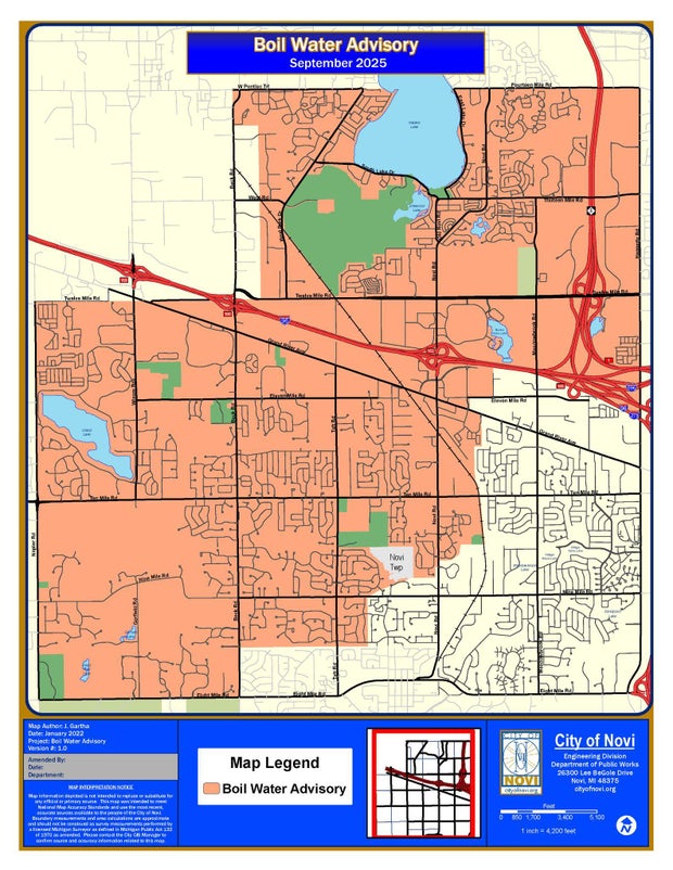
The city of Novi, Michigan, posted this map of a boil water advisory region on Sept. 26, 2025, the day after a massive water main break on 14 Mile Road.City of Novi, Michigan
But the boil water advisories for Walled Lake and the Novi neighborhoods that lost water remain in effect until further notice. The city of Novi said Friday morning that it expects the boil water advisory for its residents to remain in effect until Sunday.
Outdoor water use
An outdoor water use restriction was posted for Novi and for nearby West Bloomfield, with residents asked to turn off irrigation systems to help ease water demand in the region.
GLWA didn’t specifically mention outdoor water use in its Friday morning report, but the water authority is asking all residents in the affected communities “to conserve water resources over the weekend to limit any additional stress on the system.”
School closures
Several schools in the affected communities were closed Thursday. The announcements for Friday include:
Novi Christian Academy announced it will be closed Friday.
Detroit Catholic Central High School will be in session, but students are asked to bring their own water bottles.
Utah geoscientist’s analysis of carbon and oxygen isotopes documents profound human-driven changes arising from agriculture and rail causeway.
Source: University of Utah
Summary:Scientists found that Great Salt Lake’s chemistry and water balance were stable for thousands of years, until human settlement. Irrigation and farming in the 1800s and a railroad causeway in 1959 created dramatic, lasting changes. The lake now behaves in ways unseen for at least 2,000 years.Share:
FULL STORY
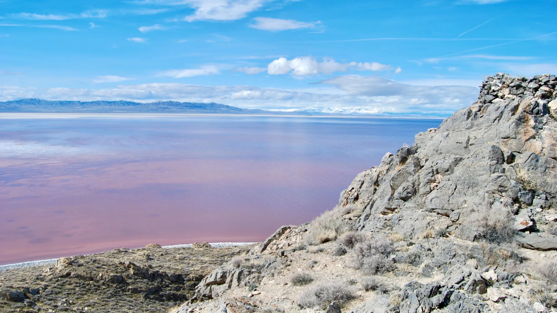
The view of Great Salt Lake’s North Arm from Gunnison Island, which has long served as a nesting ground for pelicans. Credit: Brian Maffly, University of Utah
Over the past 8,000 years, Utah’s Great Salt Lake has been sensitive to changes in climate and water inflow. Now, new sediment isotope data indicate that human activity over the past 200 years has pushed the lake into a biogeochemical state not seen for at least 2,000 years.
A University of Utah geoscientist applied isotope analysis to sediments recovered from the lake’s bed to characterize changes to the lake and its surrounding watershed back to the time the lake took its current shape from the vast freshwater Lake Bonneville that once covered much of northern Utah.
“Lakes are great integrators. They’re a point of focus for water, for sediments, and also for carbon and nutrients,” said Gabriel Bowen, a professor and chairman of the Department of Geology & Geophysics. “We can go to lakes like this and look at their sediments and they tell us a lot about the surrounding landscape.”
Sedimentary records provide context for ongoing changes in terminal saline lakes, which support fragile, yet vital ecosystems, and may help define targets for their management, according to Bowen’s new study, published last month in Geophysical Research Letters.
This research helps fill critical gaps in the lake’s geological and hydrological records, coming at a time when the drought-depleted level of the terminal body has been hovering near its historic low.
“We have all these great observations, so much monitoring, so much information and interest in what’s happening today. We also have a legacy of people looking at the huge changes in the lake that happened over tens of thousands and hundreds of thousands of years,” Bowen said. “What we’ve been missing is the scale in the middle.”
That is the time spanning the first arrival of white settlers in Utah but after Lake Bonneville receded to become Great Salt Lake.
By analyzing oxygen and carbon isotopes preserved in lake sediments, the study reconstructs the lake’s water and carbon budgets through time. Two distinct, human-driven shifts stand out:
Mid-19th century – Coinciding with Mormon settlement in 1847, irrigation rapidly greened the landscape around the lake, increasing the flow of organic matter into the lake and altering its carbon cycle.
Mid-20th century – Construction of the railroad causeway in 1959 disrupted water flow between the lake’s north and south arms, which turned Gilbert Bay from a terminal lake to an open one that partially drained into Gunnison Bay, altering the salinity and water balance to values rarely seen in thousands of years.
The new study examines two sets of sediment cores extracted from the bed of Great Salt Lake, each representing different timescales. The top 10 meters of the first core, drilled in the year 2000 south of Fremont Island, contains sediments washed into the lake up to 8,000 years ago.
The view of the Great Salt Lake from Gunnison Island, which has long served as a nesting ground for pelicans. Credit: Brian Maffly
The other samples, recovered by the U.S. Geological Survey, represent only the upper 30 centimeters of sediments, deposited in the last few hundred years.
“The first gives us a look at what was happening for the 8,000 years before the settlers showed up here,” Bowen said. “The second are these shallower cores that allow us to see how the lake changed after the arrival of the settlers.”
Bowen subjected these lakebed sediments at varying depths to an analysis that determines isotope ratios of carbon and oxygen, shedding light on the landscape surrounding the lake and the water in the lake at varying points in the past.
“The carbon tells us about the biogeochemistry, about how the carbon cycles through the lake, and that’s affected by things like weathering of rocks that bring carbon to the lake and the vegetation in the watershed, which also contributes carbon that dissolves into the water and flows to the lake,” he said.
Bowen’s analysis documented a sharp change in carbon, indicating profound changes that coincided with the arrival of Mormon pioneers in the Salt Lake Valley, where they introduced irrigated agriculture to support a rapidly growing community.
“We see a big shift in the carbon isotopes, and it shifts from values that are more indicative of rock weathering, carbon coming into the lake from dissolving limestone, toward more organic sources, more vegetation sources,” Bowen said.
The new carbon balance after settlement was unprecedented during the 8,000 years of record following the demise of Lake Bonneville.
Next, Bowen’s oxygen isotope analysis reconstructed the lake’s water balance over time.
“Essentially, it tells us about the balance of evaporation and water inflow into the lake. As the lake is expanding, the oxygen isotope ratio goes down. As the lake shrinks, it goes up, basically telling us about the rate of change of the lake volume. We see little fluctuations, but nothing major until we get to 1959.”
That’s the year Union Pacific built a 20-mile causeway to replace a historic rail trestle, dividing the lake’s North Arm, which has no tributaries, from its South Arm, also known as Gilbert Bay, which receives inflow from three rivers. Water flows through a gap in the causeway into North Arm, now rendering the South Arm an open system.
“We changed the hydrology of the lake fundamentally and gave it an outflow. We see that really clearly in the oxygen isotopes, which start behaving in a different way,” he said. Counterintuitively, the impact of this change was to make Gilbert Bay waters fresher than they would have been otherwise, buying time to deal with falling lake levels and increasing salinity due to other causes.
“If we look at the longer time scale, 8,000 years, the lake has mostly been pinned at a high evaporation state. It’s been essentially in a shrinking, consolidating state throughout that time. And that only reversed when we put in the causeway.”
The paper, “Multi-millennial context for post-colonial hydroecological change in Great Salt Lake,” was posted online July 22 in the journal Geophysical Research Letters. Gabriel Bowen is the sole author and is supported by grants from the National Science Foundation.
A drone view shows a herd of cattle searching for water amid a severe drought that has dried up Suva Planina mountain’s main springs, near the town of Bela Palanka, Serbia August 12, 2025. REUTERS/Djordje Kojadinovic
SUVA PLANINA, Serbia (Reuters) -A prolonged drought and sweltering heat are taking their toll on villagers, livestock and crops in the mountains of southeastern Serbia, with animals starting to die.
Lack of rainfall since May has caused water shortages, wildfires and disruption to agriculture across the Western Balkans, also comprised of Montenegro, Bosnia, Albania, Kosovo and North Macedonia,
At Serbia’s Suva Planina (Dry Mountain), owners who take their cows and horses for summer grazing said the springs dried up too early this year.
“There’s not a drop of water … animals are starting to die,” said Ljubisa Petkovic, a herder from the nearby municipality of Gadzin Han.
Around 1,000 thirsty cows and horses milled round a few watering holes and springs, sipping sparse and dirty water from puddles.
Temperatures in Serbia on Tuesday stood at around 35 degrees Celsius (95 Fahrenheit) with several wildfires burning.
In late July, local authorities, alerted by cattle owners, drove water trucks up the Suva Planina pastures, filled a pond, and pledged to send more.
Nikola Manojlovic, 35, said he hoped for more state water supplies and warned that villages in the valley were also suffering from the drought.
“Corn has dried up … we’ve had no running water in the village for three months now and we have no water here,” Manojlovic said.
Meteorologists say Serbia may have a spell of rainy weather later this month, but it may not be enough to replenish the small rivers, lakes and creeks needed for the cattle to drink.
(Reporting by Branko Filipovicc; Writing by Aleksandar Vasovic; Editing by Andrew Cawthorne)