Summary:In 2023, the world’s oceans experienced the most intense and widespread marine heatwaves ever recorded, with some events persisting for over 500 days and covering nearly the entire globe. These searing ocean temperatures are causing mass coral bleaching and threatening fisheries, while also signaling deeper, system-wide climate changes.
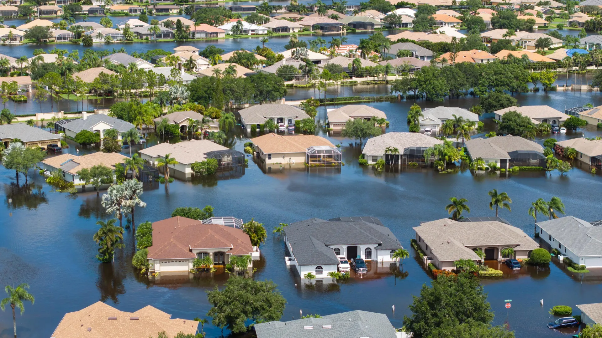
Marine heatwaves surged to record-breaking levels in 2023, disrupting ecosystems and fisheries across 96% of the ocean. Scientists warn this may mark the beginning of a fundamental climate shift. Credit: Shutterstock
The global marine heatwaves (MHWs) of 2023 were unprecedented in their intensity, persistence, and scale, according to a new study. The findings provide insights into the region-specific drivers of these events, linking them to broader changes in the planet’s climate system. They may also portend an emerging climate tipping point. Marine heatwaves (MHWs) are intense and prolonged episodes of unusually warm ocean temperatures.
These events pose severe threats to marine ecosystems, often resulting in widespread coral bleaching and mass mortality events. They also carry serious economic consequences by disrupting fisheries and aquaculture. It’s widely understood that human-driven climate change is driving a rapid increase in the frequency and intensity of MHWs.
In 2023, regions across the globe, including the North Atlantic, Tropical Pacific, South Pacific, and North Pacific, experienced extreme MHWs. However, the causes underlying the onset, persistence, and intensification of widespread MHWs remain poorly understood.
To better understand the MHWs of 2023, Tianyun Dong and colleagues conducted a global analysis using combined satellite observations and ocean reanalysis data, including those from the ECCO2 (Estimating the Circulation and Climate of the Ocean-Phase II) high-resolution project.
According to the findings, MHWs of 2023 set new records for intensity, duration, and geographic extent, lasting four times the historical average and covering 96% of the global ocean surface. Regionally, the most intense warming occurred in the North Atlantic, Tropical Eastern Pacific, North Pacific, and Southwest Pacific, collectively accounting for 90% of the oceanic heating anomalies.
The researchers show that the North Atlantic MHW, which began as early as mid-2022, persisted for 525 days, while the Southwest Pacific event broke prior records with its vast spatial extent and prolonged duration. What’s more, in the Tropical Eastern Pacific, temperature anomalies peaked at 1.63 degrees Celsius during the onset of El Niño.
Using a mixed-layer heat budget analysis, the scientists discovered diverse regional drivers contributing to the formation and persistence of these events, including increased solar radiation due to reduced cloud cover, weakened winds, and ocean current anomalies. According to the researchers, the 2023 MHWs may mark a fundamental shift in ocean-atmosphere dynamics, potentially serving as an early warning of an approaching tipping point in Earth’s climate system.
Summary:An ancient glacier high in the French Alps has revealed the oldest known ice in Western Europe—dating back over 12,000 years to the last Ice Age. This frozen archive, meticulously analyzed by scientists, captures a complete chemical and atmospheric record spanning humanity’s transition from hunter-gatherers to modern industry. The core contains stories of erupting volcanoes, changing forests, Saharan dust storms, and even economic impacts across history. It offers a rare glimpse into both natural climate transitions and human influence on the atmosphere, holding vital clues for understanding past and future climate change.Share:
FULL STORY
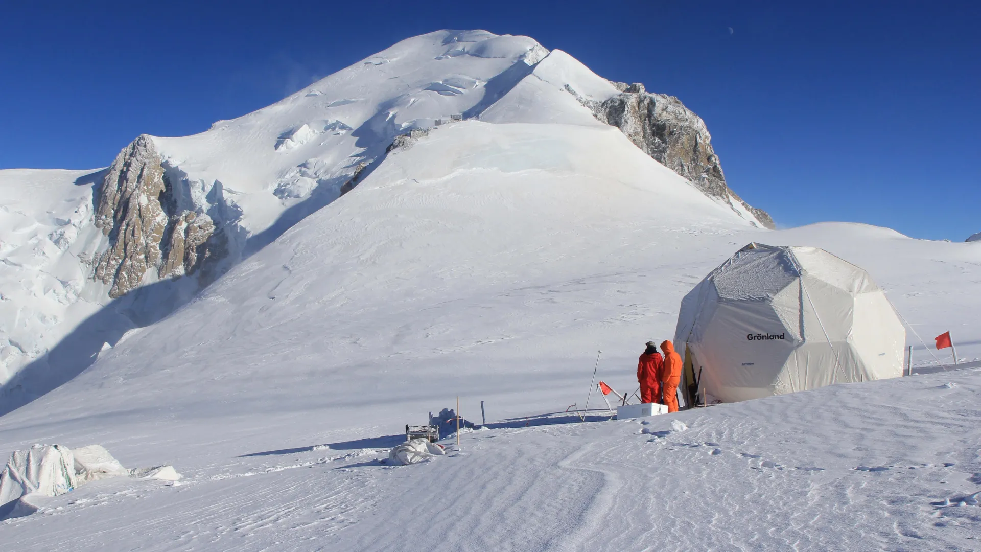
The 1999 expedition team collecting the ice core from Dome du Goûter on the shoulder of Mont Blanc. Credit: LGGE/OSUG, Bruno Jourdain
Glaciers hold layers of history preserved in ice, offering unique insights into Earth’s past that can also help us interpret the future. Trapped amidst the frozen water are microscopic deposits of dust, pollen, and even pollutants that scientists can use to examine environmental changes through time. DRI’s Ice Core Lab has used this technique to highlight atmospheric lead pollution and economic turbulence in Ancient Rome. Now, their latest study found that a glacier in the French Alps dates back to the last Ice Age – the oldest known glacier ice in the region. Serving as a record that spans through the development of agriculture in Western Europe and the advent of industrialization, the glacier holds insights into an era of rapid change.
The new study, published in the June issue of PNAS Nexus, examines a 40-meter long ice core from Mont Blanc’s Dôme du Goûter. Using radiocarbon dating techniques, the research team found that the glacier provides an intact record of aerosols and climate dating back at least 12,000 years. Aerosols are small droplets and particles in the air such as desert dust, sea salts, sulfur from volcanic eruptions, soot from forest fires, as well as pollutants and other emissions from human activities. Glacier ice offers the most detailed record of past atmospheric aerosols, and this is the first ice core record from the European region that extends back to the last climatic transition. Aerosols play an important role in regional climate through their interactions with clouds and solar radiation, and the insights offered by the ice record can help inform accurate climate modeling for both the past and future.
“For the first time, we have a fairly complete Alpine record of atmospheric and precipitation chemistry going all the way back to the Mesolithic Period,” said Joe McConnell, Director of DRI’s Ice Core lab who co-authored the study. “And that’s a big deal, because you have two major climate states – glacial and interglacial – and to get a record of atmospheric precipitation chemistry across that huge climate change tells you the most extreme natural aerosol concentrations that you’d expect. On top of that, you have humans going from hunter-gatherers with a very low population through the development of agriculture, domestication of animals, mining, etc, and then a vast population increase and the clearing of land. All of that is happening around this ice core site. It spans the full range of natural and anthropogenic change, and it’s right in the center of Europe – where much of Western civilization evolved.”
The glacier’s location in the Alps is important because it serves as a more intact record of Europe’s local climate than those found in distant Arctic ice. Many aerosols play important roles in driving Earth’s climate, so scientists would like to know how sources and concentrations in the air have varied in the past.
“Ice cores collected from glaciers and ice sheets can provide such information, but since these droplets and particles stay in the air only for a few days to maybe a week, records developed from glaciers close to the sources often are the most informative,” said lead author, Michel Legrand.
The ice core analyzed in this study was first collected in 1999 by some of the study’s French authors. It was stored in a freezer in France for more than 20 years before McConnell and his team brought it to DRI’s Ice Core Lab in Reno, Nevada, where specialized equipment and methods known as continuous flow analysis allowed it to be melted down and the chemistry measured, layer by icy layer.
“Determining what year or period of time a layer in the ice represents can be challenging, so here we used a unique combination of radiometric methods to establish the chronology in the ice,” said coauthor Werner Aeschbach.
“We were relieved to find that even under the unusually warm climate of the 20th century, the cold temperatures at over 14,000 feet near Mont Blanc’s peak had preserved the glacier so that the ice record hadn’t yet been impacted by melting,” said co-author Nathan Chellman.
The historic age of the ice at the base of the core, around 40 meters deep into the glacier, surprised the researchers. Another core collected from a glacier located less than 100 meters away at Col du Dome was found to contain ice only about a century old, despite being much deeper. The scientists attribute this to the strong wind patterns found on Mont Blanc.
“It’s exciting to find the first ice core from the European Alps containing an intact record of climate that extends back through the current ten-thousand-year warm period and into the very different climate of the last ice age,” said coauthor Susanne Preunkert, who was a member of the field team that collected the ice core in 1999.
Insights into Europe’s Past Climate
The uniquely detailed ice record revealed a temperature difference of about 3 degrees Celsius between the last Ice Age and the current Holocene Epoch. Using pollen records embedded in the ice, reconstructions of summer temperatures during the last Ice Age were about 2 degrees Celsius cooler throughout western Europe, and about 3.5 degrees Celsius cooler in the Alps.
The phosphorous record also told researchers the story of vegetation changes in the region over the last 12,000 years. Phosphorous concentrations in the ice were low during the last Ice Age, increased dramatically during the early to mid-Holocene, and then decreased steadily into the late Holocene. This is consistent with the spread of forests under the warmer climate, and their decline following the proliferation of modern society and the land-clearing that resulted from agriculture and the spread of industry.
Records of sea salt also helped the researchers examine changes in historical wind patterns. The ice core revealed higher rates of sea salt deposition during the last Ice Age that may have resulted from stronger westerly winds offshore of western Europe. Sea salt aerosols can scatter solar radiation back to space and affect climate via their impacts on cloud droplet, size, and albedo, making them important drivers of the regional climate.
The ice record tells a more dramatic story for the changes in dust aerosols during the climatic shift. Dust serves as an important driver of climate by both absorbing and scattering incoming solar radiation and outgoing planetary radiation, and impacts cloud formation and precipitation by acting as cloud condensation nuclei. During the last Ice Age, dust was found to be about 8-fold higher compared to the Holocene. This contradicts the mere doubling of dust aerosols between warm and cold climate stages in Europe simulated by prior climate models. The difference may be explained by increased plumes of Saharan dust depositing in Europe, which remains the main source of dust in the region. The ice core record is consistent with other paleoclimate records that suggest more arid conditions over the Mediterranean during colder climates.
The 1999 expedition team collecting the ice core from Dome du Goûter on the shoulder of Mont Blanc. Credit: LGGE/OSUG, Bruno Jourdain
Uncovering More Stories Entombed in the Ice
This study is only the beginning of the Mont Blanc ice record’s story, as the researchers plan to continue analyzing it for indicators of human history. The first step in uncovering every ice core’s record is to use isotopes and radiocarbon dating to establish how old each layer of ice is. Now, with that information, the scientists can take an even deeper look at what it can tell us about past human civilizations and their impact on the environment.
“Now we can start to interpret all these other records that we have of lead and arsenic and other things like that, in terms of human history,” said McConnell.
The information can also be used to help interpret how changes in aerosols impact the climate and improve modeling to help us understand current and future climatic shifts.
“If you’re really going to go back and examine all possible climate states, past and future, you need a model that captures true climate variability,” McConnell said. “It’s a laudable goal, but to evaluate how good the models are, you’ve got to be able to compare them to observations, right? And that’s where the ice cores come in.”
New research finds long-term impacts on flood size and frequency decades after trees are removed
Clear-cutting forests doesn’t just raise flood risk — it can supercharge it. UBC researchers found that in certain watersheds, floods became up to 18 times more frequent and over twice as severe after clear-cutting, with these effects lasting more than four decades. The surprise? Terrain details like which direction a slope faces played a huge role in flood behavior. Conventional models miss these dynamics, which could mean we’ve been underestimating the danger for decades — especially as climate change accelerates extreme weather.Share:
FULL STORY
Clear-cutting can make extreme floods dramatically more frequent and severe, especially depending on subtle terrain features. The effects can last more than 40 years, far longer than expected. Credit: Shutterstock
Clear-cutting can make catastrophic floods 18 times more frequent with effects lasting more than 40 years, according to a new UBC study.
In one watershed, these extreme floods also became more than twice as large, turning a once-in-70-years event into something that now happens every nine.
“This research challenges conventional thinking about forest management’s impact on flooding,” said senior author Dr. Younes Alila, a hydrologist in the UBC faculty of forestry. “We hope the industry and policymakers will take note of the findings, which show that it matters not only how much forest you remove but also where, how and under what conditions.”
Same treatment, different floods
The UBC-led study draws on one of the world’s longest-running forest experiments at the Coweeta Hydrologic Laboratory in North Carolina and is published in the Journal of Hydrology.
The research team analyzed two adjacent watersheds, one north-facing, the other south-facing, that were both clear-cut in the late 1950s.
“We found seemingly minor landscape factors — like the direction a slope faces — can make or break a watershed’s response to treatment,” said first author Henry Pham, a doctoral student in the faculty of forestry.
In the north-facing watershed, which receives less direct sunlight and retains more moisture, floods became four to 18 times more frequent. Average flood sizes increased by 47 percent compared to pre-treatment levels, and the biggest floods grew by as much as 105 percent.
In the south-facing watershed, the same treatment had virtually no impact on flood behavior.
Old flood models inadequate
Most conventional flood models use simplified assumptions: cut X percent of trees, expect Y percent more water runoff. But this study found that such models fail to account for extreme and erratic flood patterns that emerge after landscape disturbances.
“This experimental evidence validates our longstanding call for better analysis methods,” said Dr. Alila. “When we apply proper probabilistic tools to long-term data, we find much stronger and more variable impacts than older models suggest.”
In short, he adds, forest treatments don’t just raise average flood levels — they can fundamentally reshape a watershed’s entire flood regime, making rare and catastrophic events much more common.
The most concerning finding was that flood effects in the north-facing watershed persisted for over 40 years, confirming that forestry treatments can lead to long-term changes in a watershed’s flood response, especially as climate change brings more extreme weather, putting downstream communities at greater risk.
Policy implications
The findings have immediate relevance for forest management practices, particularly in B.C. where there are similar terrain types and forestry operations in the form of clear-cut logging.
Dr. Alila noted that the model used in this study can be used to predict which parts of B.C. are currently more at risk of extreme flooding. It can also be used to investigate how much of the severity of Sumas Prairie floods in 2021 and the more recent Texas floods can be attributed to global warming and/or land use and forest cover changes.
“Our findings highlight how multiple landscape factors interact in complex ways. As climate conditions shift, understanding those dynamics is becoming increasingly important for forest and water management.”
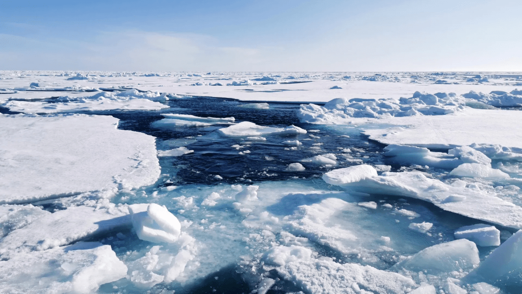
By analyzing ancient ocean seafloor sediments and running detailed climate simulations, the research team found no evidence for the presence of a thick ice shelf. Instead, this study paints a picture of an Arctic that, despite being cold and icy, still had open water areas that allowed for biological activity and ocean circulation. Credit: Morven Muilwijk
For years, scientists have debated whether a giant thick ice shelf once covered the entire Arctic Ocean during the coldest ice ages. Now a new study published in Science Advances, challenges this idea as the research team found no evidence for the presence of a massive ~1km ice shelf. Instead, the Arctic Ocean appears to have been covered by seasonal sea ice — leaving open water and life-sustaining conditions even during the harshest periods of cold periods during the last 750,000 years. This discovery gives insights crucial for our understanding of how the Arctic has responded to climate change in the past — and how it might behave in the future.
Tiny traces of life in ancient mud
Led by the European Research Council Synergy Grant project Into the Blue — i2B, the research team studied sediment cores collected from the seafloor of the central Nordic Seas and Yermak Plateau, north of Svalbard. These cores hold tiny chemical fingerprints from algae that lived in the ocean long ago. Some of these algae only grow in open water, while others thrive under seasonal sea ice that forms and melts each year.
“Our sediment cores show that marine life was active even during the coldest times,” said Jochen Knies, lead author of the study, based at UiT The Arctic University of Norway and co-lead of the Into The Blue — i2B project. “That tells us there must have been light and open water at the surface. You wouldn’t see that if the entire Arctic was locked under a kilometre-thick slab of ice.”
One of the key indicators the team looked for was a molecule called IP25, which is produced by algae that live in seasonal sea ice. Its regular appearance in the sediments shows that sea ice came and went with the seasons, rather than staying frozen solid all year round.
Simulating ancient Arctic climates
To test the findings based on the geological records, the research team used the AWI Earth System Model — a high-resolution computer model — to simulate Arctic conditions during two especially cold periods: the Last Glacial Maximum around 21,000 years ago, and a deeper freeze about 140,000 years ago when large ice sheets covered a lot of the Arctic.
“The models support what we found in the sediments,” said Knies. “Even during these extreme glaciations, warm Atlantic water still flowed into the Arctic gateway. This helped keep some parts of the ocean from freezing over completely.”
The models also showed that the ice wasn’t static. Instead, it shifted with the seasons, creating openings in the ice where light could reach the water — and where life could continue to thrive. This research not only reshapes our view of past Arctic climates but also has implications for future climate predictions. Understanding how sea ice and ocean circulation responded to past climate extremes can improve models that project future changes in a warming world.
“These reconstructions help us understand what’s possible — and what’s not — when it comes to ice cover and ocean dynamics,” said Gerrit Lohmann, co-author of this study, based at Alfred Wegener Institute, Helmholtz Centre for Polar and Marine Research (AWI) and co-lead of Into The Blue — i2B. “That matters when trying to anticipate how ice sheets and sea ice might behave in the future.”
Re-thinking the giant ice shelf theory
Some scientists have argued that features on the Arctic seafloor suggest that a huge, grounded ice shelf once covered the entire ocean. But this new study offers another explanation.
“There may have been short-lived ice shelves in some parts of the Arctic during especially severe cold phases,” said Knies. “But we don’t see any sign of a single, massive ice shelf that covered everything for thousands of years.”
One possible exception could have occurred about 650,000 years ago, when biological activity in the sediment record dropped sharply. But even then, the evidence points to a temporary event, not a long-lasting frozen lid over the Arctic.
Understanding the Arctic’s future
The study sheds new light on how the Arctic has behaved under extreme conditions in the past. This matters because the Arctic is changing rapidly today. Knowing how sea ice and ocean circulation responded to past climate shifts helps scientists understand what might lie ahead.
“These past patterns help us understand what’s possible in future scenarios,” said Knies. “We need to know how the Arctic behaves under stress — and what tipping points to watch for — as the Arctic responds to a warming world.”
The full paper, “Seasonal sea ice characterized the glacial Arctic-Atlantic gateway over the past 750,000 years,” is available in Science Advances.
This research is part of the European Research Council Synergy Grant project Into the Blue — i2B and the Research Council of Norway Centre of Excellence, iC3: Centre for ice, Cryosphere, Carbon, and Climate.
World Water Day is held every year on 22 March to raise awareness of global freshwater challenges and solutions.
This year’s theme is Glacier Preservation, highlighting how their rapid melting threatens water security and livelihoods.
World Water Day is held every year on 22 March, and is a United Nations (UN) day focused on raising awareness of the importance of freshwater.
This year’s World Water Day theme, Glacier Preservation, highlights the urgent need to protect glaciers, as their rapid melting threatens water security, ecosystems and livelihoods, requiring collective global and local action.
“Glaciers may be shrinking, but we cannot shrink from our responsibilities … Action this year is critical. Every country must deliver strong national climate action plans aligned with limiting global temperature rise to 1.5 degrees Celsius,” reminds UN Secretary-General, António Guterres.
This year’s theme is Glacier Preservation. Image: United Nations
In 2021, more than 2 billion people lived in water-stressed countries. This is expected to be made worse as a result of climate change and population growth.
And so World Water Day has been observed since 1993 to highlight the work that remains to ensure everyone on Earth has access to clean drinking water. And while it’s a high-profile issue – check out our podcast with Matt Damon below – the figures above emphasize the challenges that remain, especially with freshwater usage increasing each year.
The World Health Organization warns that “historical rates of progress would need to double” for the world to achieve universal coverage of basic drinking water services by the end of the decade.
Only 0.5% of water on Earth is useable and available freshwater – and climate change is dangerously affecting that supply, says the World Meteorological Association. Over the past 20 years, terrestrial water storage – including soil moisture, snow and ice – has dropped at a rate of 1cm per year, with major ramifications for water security.
Natural resource shortages, including water insecurity, is a major risk over the next decade. Image: World Economic Forum
From climate change to urbanization and demographic changes, water supply systems face numerous risks. Indeed, the World Economic Forum’s Global Risks Report 2025lists “natural resource shortages” as the 4th biggest risk over the next decade.
That’s why raising awareness on conserving and protecting freshwater for everyone on Earth is vital, especially as the world looks to find – and implement – solutions.
Water and climate change are inextricably linked, with glaciers playing a critical role in maintaining freshwater availability. Rising global temperatures are accelerating glacial melt, disrupting the seasonal flow of meltwater that feeds major river systems. These rivers support agriculture, drinking water supply, and hydropower for millions of people, particularly in lowland regions.
As glaciers recede, water sources become less predictable, leading to prolonged droughts, reduced soil moisture, and declining groundwater levels. At the same time, excessive glacial melting can contribute to flooding, landslides and glacial lake outburst floods, endangering communities and infrastructure. These disruptions affect ecosystems, food security and livelihoods, making glacial melt a key driver of water-related challenges in a changing climate.
Find out more about the challenges in the session below from our Annual Meeting in 2024 –Out of Balance with Water.
Innovation to help improve water security
Innovation and entrepreneurial thinking can also help conserve and protect freshwater sources. The World Economic Forum’s UpLink platform supports purpose-driven entrepreneurs by building ecosystems to help scale their businesses, focusing on solutions for global challenges such as climate change, ecosystem degradation and inequality.
One of its Top Innovators is a Latin American Climatech company connecting farmers seeking to improve irrigation practices with companies focused on water security. Kilimo implements measurable, auditable actions that deliver water volumetric benefits through partnerships between farmers and companies. With this business model, it aims to promote climate adaptation and ensure water availability for communities, ecosystems and economic development.
Meanwhile, the video below shows how sustainable water management practices, including conservation techniques like Ice Stupas and Glacial Grafting, can help mitigate some of these challenges by supporting water storage and availability in vulnerable regions.
Collaboration between public and private sectors has a significant role to play in providing clean water for all, and ensuring a sustainable, resilient global water system. The Forum’s Water Futures Community is a collaborative platform driving solutions and finance to address emerging water challenges, advancing the global water agenda through dialogue and partnerships.