Greenland is turning green. The ice sheets and glaciers on the world’s largest island are melting, leading to the growth of vegetation. A new study shows large areas where ice used to be, now have shrubs, wetlands, or barren rock for the first time since the Vikings visited 1,000 years ago. A team of scientists from the University of Leeds attribute the conditions to warmer air temperatures, which have been heating up at twice the global average.
Credit: NASA Goddard Space Flight Center
Ice and snow reflect the sun’s energy keeping Earth cooler, but as temperatures rise, the melting exposes bedrock that absorbs energy. The bare places are then colonized by tundra or treeless ecosystems and eventually shrublands. The melting ice also moves sediment and silt to form wetlands that can release the potent greenhouse gas methane as microbes feed on organic material.
Over a 30-year period, the amount of land with vegetation in Greenland doubled by more than 33,000 square miles, which in addition to increasing greenhouse gas emissions, will contribute to shifting landscapes and sea level rise.
The scientists also say that permafrost, which is a frozen layer beneath Earth’s surface, is being degraded and could affect communities, buildings, and infrastructure.
Nitrogen and phosphorus pollution from fertilizer runoff and sewage is a global problem that creates algal blooms in rivers and lakes and dead zones in oceans, where a lack of oxygen diminishes water quality and kills aquatic life. But, according to a team of scientists, there could be a beautiful solution—flowers!
The researchers say the cut flowers could pay for themselves and even turn a profit. | Credit: Margi Rentis, CC BY-ND|
Researchers from Florida International University grew marigolds through holes on floating mats in canals near Miami, in a method similar to hydroponics. Instead of getting nutrients from soils, the plants soaked up nitrogen and phosphorus from the polluted water to thrive. And boy they did thrive. The plants blossomed into long, marketable stems with large blooms in quantities that matched typical flower farm production—all while removing 52 percent more phosphorus and 36 percent more nitrogen than would occur naturally.
The bigger the plants grew, the cleaner the water got, which the researchers say could not only solve a vexing pollution problem but also contribute to the area’s economy. Eighty percent of the nation’s bouquet flowers are imported from South America through the Miami International Airport, and the team says the blossoms they grow could be sold to local florists and provide jobs.
Wetlands extract harmful nutrients from water, but many have been eliminated by development. These floating flower wetlands could be an effective way to stemthe tide of pollution worldwide.
There is urgency for the seven states that rely on the Colorado River to reach an agreement on how to keep water levels high enough in its two major reservoirs. Climate change is threatening water delivery and power systems as the region becomes drier.
Lake Mead, 2022 | Credit: NASA Earth Observatory
The states—Colorado, Utah, Wyoming, New Mexico, Arizona, Nevada, and California—have until next month to agree on alternatives to keep the system afloat for the next couple of decades and submit them to the Bureau of Reclamation. If they don’t, the bureau will propose its own plan for cuts to allocations from the river, which supplies 40 million people and agriculture.
However, there’s a wrinkle in the negotiations. A report released by the bureau on February 8 concluded that 1.3 million acre-feet of water was lost annually to evaporation and transpiration in the three Lower Basin states of Arizona, California, and Nevada. Water lost to evaporation and transpiration has not been considered under the current rules. Despite evaporation and transpiration, the three lower states have continued to draw down from the reservoirs that are threatened by aridification.
Now, all of the Colorado River Basin states, except California, have submitted a letter to the federal government proposing that in times of low water levels, there would be cuts in allocations—most heavily to California—that take evaporation and transpiration into account. The Los Angeles Timesreports that agencies in Southern California would be required to endure the largest cuts, up to 32 percent for evaporation losses if Lake Powell and Lake Mead hit crisis levels. California has proposed a more modest plan that it argues does not rewrite the rules of the river, which are based on historic water rights. Because of the winter snowpack last year, recent storms, and conservation, water levels at Lake Mead, the country’s largest reservoir, are currently about 40 feet higher than was projected.
Added to the federal government’s deadline for the states to come up with a plan for cutbacks, is the fear that a different administration after the November election could change those involved at the federal level.
Source:Goethe University FrankfurtSummary:Global scientists warn that humanity is on the verge of crossing irreversible climate thresholds, with coral reefs already at their tipping point and polar ice sheets possibly beyond recovery. The Global Tipping Points Report 2025 reveals how rising temperatures could trigger a cascade of system collapses, from the Amazon rainforest turning to savanna to the potential shutdown of the Atlantic Ocean circulation.Share:
FULL STORY
Rising temperatures have pushed coral reefs to the brink and may have already destabilized parts of the polar ice sheets. Scientists warn of cascading climate failures but see hope in emerging positive social and technological shifts. Credit: Shutterstock
In a recently released report, a team of international climate scientists warns that saving many tropical coral reefs from destruction caused by rising ocean temperatures will now require extraordinary effort. The researchers also conclude that some regions of the polar ice sheets may have already crossed their tipping points. If this melting continues, it could cause irreversible sea level rise measured in several meters.
Scientists Warn of Cascading Climate System Failures
Among the lead authors of the Global Tipping Points Report 2025 (GTPR 2025) is Nico Wunderling, Professor of Computational Earth System Sciences at Goethe University’s Center for Critical Computational Studies | C3S and researcher at the Senckenberg Research Institute Frankfurt. Together with several co-authors, he led the chapter on “Earth System Tipping Points and Risks.”
Wunderling explains: “The devastating consequences that arise when climate tipping points are crossed pose a massive threat to our societies. There is even a risk of the tipping of one climate system potentially triggering or accelerating the tipping of others. This risk increases significantly once the 1.5°C threshold is exceeded.”
The World Nears a Cascade of Climate Tipping Points
According to the report, scientists have identified roughly two dozen parts of the global climate system that could reach tipping points. The first of these, involving tropical coral reefs, appears to have already been surpassed. The report projects that the global average temperature will rise 1.5°C above pre-industrial levels within the next few years. This would mark the start of a period in which multiple tipping points could be crossed, with profound outcomes such as rapid sea level rise from melting ice sheets or global temperature disruptions caused by a breakdown of the Atlantic Ocean circulation. The authors also recommend actions to prevent further temperature increases.
The coordinating lead author of the GTPR 2025 is Tim Lenton, Professor at the University of Exeter’s (UK) Global Systems Institute. More than 100 scientists from over 20 countries contributed to the report, which was released ahead of the 30th World Climate Conference beginning November 10, 2025, in Belém, Brazil. First published in 2023, the Global Tipping Points Report has already gained recognition as a leading reference for assessing both the risks and potential benefits of negative and positive tipping points within the Earth system and human societies.
Understanding Climate Tipping Points
Climate tipping points have become a major focus in climate research only within the past two decades. The GTPR authors describe a climate-induced tipping point as a level of warming at which key natural systems — such as coral reefs, the Amazon rainforest, or major ocean currents — undergo self-reinforcing and often irreversible change.
For example, once tropical coral reefs surpass their temperature threshold, they begin to die even if humanity later stabilizes or reduces global warming. The scientists warn that more tipping points may soon follow, as some lie near or at 1.5°C of warming. Systems already at risk include the Amazon rainforest (which could shift toward savanna), the ice sheets of Greenland and West Antarctica (which could raise sea levels by several meters), and the Atlantic Ocean circulation (whose collapse could sharply cool Europe).
Source:University of Illinois ChicagoSummary:UIC researchers predict that the Sahara Desert could see up to 75% more rain by the end of this century due to rising global temperatures. Using 40 climate models, the team found widespread precipitation increases across Africa, though some regions may dry out. The results suggest a major rebalancing of the continent’s climate. Scientists stress that adaptation planning is essential to prepare for both wetter and drier futures.Share:
FULL STORY
Climate models suggest that global warming could dramatically increase rainfall in the Sahara and other parts of Africa. Credit: Shutterstock
The Sahara Desert is known as one of the driest places on Earth, receiving only about 3 inches of precipitation each year — roughly one-tenth of what falls in Chicago.
However, new research from the University of Illinois Chicago (UIC) suggests that this could change dramatically within the next few decades. By the latter half of the 21st century, rising global temperatures may bring much more rain to the region. The study, published in npj Climate and Atmospheric Science, predicts that the Sahara could receive up to 75% more precipitation than its historical average. Similar increases are also projected for parts of southeastern and south-central Africa under extreme climate scenarios.
Rising Rainfall Could Reshape Africa
“Changing rainfall patterns will affect billions of people, both in and outside Africa,” explained lead author Thierry Ndetatsin Taguela, a postdoctoral climate researcher in UIC’s College of Liberal Arts and Sciences. “We have to start planning to face these changes, from flood management to drought-resistant crops.”
Taguela emphasized that understanding how temperature increases influence rainfall is vital for developing adaptation strategies. His research used an ensemble of 40 climate models to simulate African summer rainfall during the latter half of the 21st century (2050-2099) and compared the results with data from the historical period (1965-2014). Two climate scenarios were examined: one assuming moderate greenhouse gas emissions and another assuming very high emissions.
In both scenarios, rainfall across most of Africa was projected to rise by the end of the century, although the changes vary by region. The Sahara Desert showed the largest increase at 75%, while southeastern Africa could see about 25% more rainfall and south-central Africa about 17% more. In contrast, the southwestern part of the continent is expected to become drier, with precipitation decreasing by around 5%.
Surprising Outlook for a Dry Region
“The Sahara is projected to almost double its historical precipitation levels, which is surprising for such a climatologically dry region,” said Taguela. “But while most models agree on the overall trend of wetter conditions, there’s still considerable uncertainty in how much rainfall they project. Improving these models is critical for building confidence in regional projections.”
The increase in precipitation is largely linked to the warming atmosphere. Higher temperatures allow the air to hold more moisture, which contributes to heavier rainfall in some areas. Shifts in atmospheric circulation patterns also affect how and where rain falls, sometimes leading to both wetter and drier regions across the continent.
“Understanding the physical mechanisms driving precipitation is essential for developing adaptation strategies that can withstand both wetter and drier futures,” Taguela said.
Taguela conducts his work as part of UIC’s Climate Research Lab, led by Akintomide Afolayan Akinsanola. Their team continues to investigate how changing atmospheric conditions could reshape Africa’s environment, agriculture, and long-term sustainability.
Summary:Melting Arctic ice is revealing a hidden world of nitrogen-fixing bacteria beneath the surface. These microbes, not the usual cyanobacteria, enrich the ocean with nitrogen, fueling algae growth that supports the entire marine food chain. As ice cover declines, both algae production and CO2 absorption may increase, altering the region’s ecological balance. The discovery could force scientists to revise predictions about Arctic climate feedbacks.Share:
FULL STORY
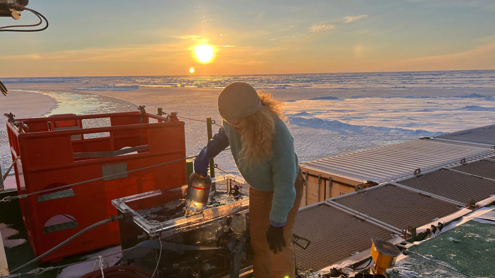
Measurements of nitrogen fixation in the Arctic Ocean aboard RV Polarstern. Credit: Rebecca Duncan
The rapid loss of sea ice in the Arctic Ocean is often seen as an environmental catastrophe. Yet researchers have found that the same melting process could help sustain life in unexpected ways. As the ice retreats, it creates conditions that encourage the growth of algae, the foundation of the Arctic’s marine food web.
Algae form the base of most ocean ecosystems, but they depend on nitrogen to grow — and nitrogen is scarce in Arctic waters. Now, an international team led by the University of Copenhagen has discovered that more nitrogen may become available than scientists once believed. This shift could reshape the future of marine life in the region and influence how much carbon the ocean can absorb.
A Hidden Source of Nitrogen Beneath the Ice
The study is the first to confirm that nitrogen fixation — a process in which certain bacteria transform nitrogen gas (N2) dissolved in seawater into ammonium — occurs beneath Arctic sea ice, even in its most remote and central areas. Ammonium not only helps these bacteria thrive but also nourishes algae and, by extension, the creatures that depend on them.
“Until now, it was believed that nitrogen fixation could not take place under the sea ice because it was assumed that the living conditions for the organisms that perform nitrogen fixation were too poor. We were wrong,” says Lisa W. von Friesen, lead author of the study and former PhD student at the Department of Biology.
Less Ice, More Life
Unlike most other oceans where cyanobacteria dominate nitrogen fixation, the Arctic Ocean relies on an entirely different group of bacteria known as non-cyanobacteria. The researchers found the highest nitrogen fixation rates along the ice edge — where melting is most intense. While these bacteria can operate beneath the ice, they flourish along the melting boundary. As climate change accelerates ice retreat, this expanding melt zone could allow more nitrogen to enter the ecosystem.
“In other words, the amount of available nitrogen in the Arctic Ocean has likely been underestimated, both today and for future projections. This could mean that the potential for algae production has also been underestimated as climate change continues to reduce the sea ice cover,” says von Friesen.
“Because algae are the primary food source for small animals such as planktonic crustaceans, which in turn are eaten by small fish, more algae can end up affecting the entire food chain,” she adds.
Could This Help the Planet Absorb More CO2?
This new nitrogen source could also influence how much carbon dioxide the Arctic Ocean takes in. More algae mean more photosynthesis, which enables the ocean to capture greater amounts of CO2.
“For the climate and the environment, this is likely good news. If algae production increases, the Arctic Ocean will absorb more CO2 because more CO2 will be bound in algae biomass. But biological systems are very complex, so it is hard to make firm predictions, because other mechanisms may pull in the opposite direction,” explains Lasse Riemann, professor at the Department of Biology and senior author of the study.
The researchers emphasize that nitrogen fixation should now be considered in models predicting the Arctic’s future. “We do not yet know whether the net effect will be beneficial for the climate. But it is clear that we should include an important process such as nitrogen fixation in the equation when we try to predict what will happen to the Arctic Ocean in the coming decades as sea ice declines,” adds Riemann.
How Nitrogen Fixation Works
In the Arctic, non-cyanobacteria perform nitrogen fixation. These microorganisms consume dissolved organic matter — often released by algae — and in turn, produce fixed nitrogen that promotes further algal growth. This exchange creates a small but vital nutrient loop beneath the ice.
Algae play a double role in the ecosystem: they are both the starting point of the marine food chain and natural absorbers of CO2. As they grow, they pull carbon dioxide from the air, which can later sink to the ocean floor as part of their biomass.
Behind the Discovery
The study, published in Communications Earth & Environment, involved scientists from the University of Copenhagen (Denmark), Linnaeus University (Sweden), Alfred Wegener Institute (Germany), Aix Marseille University (France), National Oceanography Centre (United Kingdom), Max Planck Institute for Chemistry (Germany), Stockholm University (Sweden), and the Swedish University of Agricultural Sciences (Sweden).
Their findings are based on two major research expeditions aboard the icebreakers IB Oden and RV Polarstern. Samples and measurements were collected at 13 sites across the central Arctic Ocean, including regions off northeast Greenland and north of Svalbard.
Nearly a week after leaks cut off water for about 1,500 inmates at the Montana State Prison in Deer Lodge, inmate Bryce Baltezar said it has created tension between guards and inmates
Nearly a week after leaks cut off water for about 1,500 inmates at the Montana State Prison in Deer Lodge, inmate Bryce Baltezar said things at the facility are dystopian.
“As soon as you hit the door, it smells like (urine) smacking you right in the face,” Baltezar said in a phone interview with Montana Free Press on Tuesday. The smell of human waste, he continued, has become the new normal.
Recommended Videos
Baltezar said he’s concerned about sanitation and safety for the roughly 90% of the prison’s population affected by the leak. Montana State Prison houses male inmates and had a population of 1,597 as of Wednesday.
Water supply issues at the prison started at 6 a.m. on Oct. 10. The Department of Corrections has since identified several leaks, ultimately prompting a broad water infrastructure overhaul. The department has not clarified what caused the leaks, but spokesperson Carolynn Stocker said the department “has experienced numerous service interruptions at its various facilities related to extreme weather, failing infrastructure, and more, but none have risen to this level of emergency.”
In a press release Wednesday, Stocker said the prison’s water and sewer system was built in the 1970s and that “work on the system has for the most part been limited to fixing problems, not maintaining or improving the system for the long haul.”
Stocker said that the corrections department will start installing a new water system using $21 million from House Bill 5, a state facilities-focused infrastructure bill passed during the legislative session that concluded in April.
“Years of deferred maintenance have caught up with us, and we’re finding multiple failures throughout the system. We will continue providing water to our inmates while we take on this longer fix,” Department of Corrections Director Brian Gootkin said in the press release. He has instructed teams working on new units at the prison to begin the water system work as early as next week.
“We are going to simultaneously continue our work to identify the issues with the existing system and install a modern system that will take us into the future,” Gootkin said. “This is not going to be an easy couple of months for inmates or staff, but the end result will be worth it.”
While work is ongoing, water will be temporarily unavailable in some prison units throughout the day, the release stated. There are 153 portable toilets, 13 that are ADA-compliant, and 43 portable showers at the prison, according to a Tuesday statement from Stocker. It took until the end of Wednesday for all inmates to get a chance to shower since the leaks started. Inmates receive a rationed number of water bottles daily for drinking and hygiene.
Without operational plumbing across 10 buildings, temporary facilities are in short supply, creating tension between guards and inmates, Baltezar said. He said that he has been scrutinized and sometimes berated by correctional officers while using portable toilets, and that he has “never felt so dehumanized in my whole life.”
“I literally just came into my cell and called my wife crying,” Baltezar said.
The department has enlisted a range of groups to aid the situation. About a dozen employees from other branches of the agency have arrived at the facility to assist with security. The Montana National Guard has helped manage the water supply and deploy temporary showers. Water detection firms supported corrections in locating leaks around the premises.
Stocker said the agency was unable to offer an estimate of the incident’s total cost.
___
This story was originally published by Montana Free Press and distributed through a partnership with The Associated Press.
Copyright 2025 The Associated Press. All rights reserved. This material may not be published, broadcast, rewritten or redistributed.
A portion (looking south) of the 152-mile Friant-Kern Canal, an aqueduct to convey water to augment agriculture irrigation on the east side of the San Joaquin Valley, is viewed on July 8, 2021, thirty minutes east of Fresno, Calif.
The headlines suggested a comparison with the “Zero Day” announcement in Cape Town, South Africa, during a drought in 2018. That was the projected date when water would no longer be available at household taps without significant conservation. Cape Town avoided a water shutoff, barely.
While California’s announcement represents uncharted territory and is meant to promote water conservation in what is already a dry water year, there is more to the story.
California’s drought solution
California is a semi-arid state, so a dry year isn’t a surprise. But a recent state report observed that California is now in a dry pattern “interspersed with an occasional wet year.” The state suffered a three-year drought from 2007 to 2009, a five-year drought from 2012 to 2016, and now two dry years in a row; 2020 was the fifth-driest year on record, and 2021 was the second-driest.
Coming into the 2022 water year – which began Oct. 1 – the ground is dry, reservoirs are low and the prediction is for another dry year.
Over a century ago, well before climate change became evident, officials began planning ways to keep California’s growing cities and farms supplied with water. They developed a complex system of reservoirs and canals that funnel water from where it’s plentiful to where it’s needed.
Part of that system is the State Water Project.
First envisioned in 1919, the State Water Project delivers water from the relatively wetter and, at the time, less populated areas of Northern California to more populated and drier areas, mostly in Southern California. The State Water Project provides water for 27 million people and 750,000 acres of farmland, with about 70% for residential, municipal and industrial use and 30% for irrigation. There are 29 local water agencies – the state water contractors – that helped fund the State Water Project and in return receive water under a contract dating to the 1960s.
While the State Water Project is important to these local water agencies, it is usually not their only source of water. Nor is all water in California supplied through the State Water Project. Most water agencies have a portfolio of water supplies, which can include pumping groundwater.
What does 0% mean?
Originally, the State Water Project planned to deliver 4.2 million acre-feet of water each year. An acre-foot is about 326,000 gallons, or enough water to cover a football field in water 1 foot deep. An average California household uses around one-half to 1 acre-foot of water per year for both indoor and outdoor use. However, contractors that distribute water from the State Water Project have historically received only part of their allocations; the long-term average is 60%, with recent years much lower.
Based on water conditions each year, the state Department of Water Resources makes an initial allocation by Dec. 1 to help these state water contractors plan. As the year progresses, the state can adjust the allocation based on additional rain or snow and the amount of water in storage reservoirs. In 2010, for example, the allocation started at 5% and was raised to 50% by June. In 2014, the allocation started at 5%, dropped to 0% and then finished at 5%.
This year is the lowest initial allocation on record. According to the state Department of Water Resources, “unprecedented drought conditions” and “reservoirs at or near historic lows” led to this year’s headline-producing 0% allocation.
That’s 0% of each state water contractor’s allocation; however, the department committed to meet “unmet minimum health and safety needs.” In other words, if the contractors cannot find water from other sources, they could request up to 55 gallons per capita per day of water to “meet domestic supply, fire protection and sanitation needs.” That’s about two-thirds of what the average American uses.
The department is also prioritizing water for salinity control in the Sacramento Bay Delta area, water for endangered species, water to reserve in storage and water for additional supply allocations if the weather conditions improve.
Under the current plan, there will be no water from the State Water Project for roughly 10% of California’s irrigated land. As a result, both municipal and agricultural suppliers will be seeking to conserve water, looking elsewhere for water supplies, or not delivering water. None are easy solutions.
Those who can afford to dig deeper wells have done so, while others have no water as their wells have gone dry. During the 2012-2016 drought, the Public Policy Institute of California found that a majority of affected households that lost water access from their wells were in “small rural communities reliant on shallow wells – many of them communities of color.”
As someone who has worked in California and the Western U.S. on complex water issues, I am familiar with both drought and floods and the challenges they create. However, the widespread nature of this year’s drought – in California and beyond – makes the challenge even harder.
This “zero allocation” for California’s State Water Contractors is an unprecedented early warning, and likely a sign of what’s ahead.
A recent study warned that the snowpack in Western states like California may decline by up to 45% by 2050, with low- and no-snow years becoming increasingly common. Thirty-seven cities in California have already issued moratoriums on development because of water supply concerns.
If voluntary conservation does not work, enacting mandatory conservation measures like San Jose’s tough new drought rules may be needed. The state is now weighing emergency regulations on water use, and everyone is hoping for more precipitation.
Lara B. Fowler, Senior Lecturer in Law and Assistant Director for Outreach and Engagement, Penn State Institutes of Energy and the Environment, Penn State
By Jessica MacAulay, Scott Hezlep, Madeleine Wright
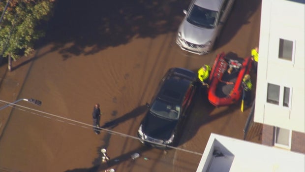
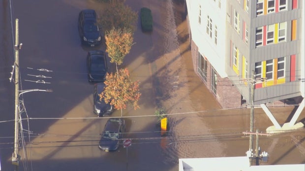
A large water main broke, gushing out 4 million gallons of water into city streets, creating a muddy mess for North Philadelphia residents near Temple University’s campus on Friday.
Chopper 3 was over the water main break at North 9th and West Berks streets shortly after 10 a.m., where crews worked to stop the flow, which took about two hours, officials said. Emergency response crews even used what appeared to be an inflatable raft to navigate the substantially flooded streets Friday morning.
CBS News Philadelphia
The Philadelphia Water Department said the water main is 30 inches wide, and the break was first reported at 8:45 a.m. The department said it was one of the largest breaks they’ve had in a while.
Officials said the water main is from 1879, and when it broke, gallons of water leaked out, flooding city streets. The water main break is just around the block — .2 miles away — from Temple University’s Kardon Atlantic Apartments.
CBS News Philadelphia
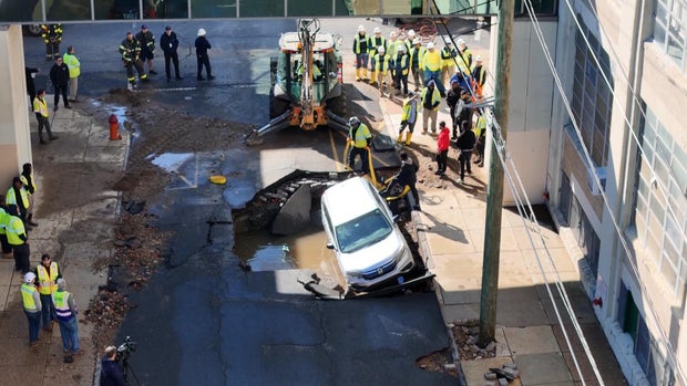
A giant hole was cracked in the ground at the intersection of North 9th Street and Montgomery Avenue. When the main broke, it caused part of the street above it to collapse, damaging a parked car owned by a Temple University chemistry student, Brian Rafferty.
Rafferty said he was getting ready for chemistry class when police called him and said his car was in a watery hole.
“It was, you know, heartbreaking to see, ’cause you know the guys were telling me that it’s probably going to be totaled,” he said.
While the cause of the break is still unknown, Philadelphia’s aging infrastructure has been a challenge for the system.
“We have about 7,000 miles of water mains and sewers altogether, and that is a system that has been built over the course of 200 years, so we are continually replacing those pipes,” Brian Rademaekers, a spokesperson for PWD, said.
CBS News Philadelphia
No one lost water service, but landlord Boris Keisserman said the basement of his rental property flooded.
“Oh, it’s awful. It’s green. Dark green, it’s like I said about 4 feet of the water down there,” he said. “This is a new construction house which I just finished a few months ago. No one lived there. Thank God. I was about to rent it out.”
The city said it plans to reimburse residents whose basements were flooded.
Once crews finish repairing the main, the Streets Department will begin fixing the road, a process expected to take several days.
Renewable energy is soaring around the globe, but one obstacle to its growth has been how to store the electricity to use it when the sun isn’t shining or the wind’s not blowing. The solution to that problem may be blowing in the wind—in the air we breathe.
Credit: Highview Power
“Liquefied air” to be exact. It’s air that has been cooled to the point it liquefies and can be stored in a tank, acting like a battery. When electricity is needed, the air is heated and expands to drive turbines that generate power. It’s super-efficient because liquifying the air generates heat. This heat can then be used to help restore the liquid to a gas.
The liquid air energy storage (LEAS) technology was first developed in the 1970s but wasn’t put into use because it’s expensive. The growth of renewables means it could now be cost effective—and a faster way to get off fossil fuels. To that point, the BBC reports, the world’s first commercial-scale liquid air energy storage facility is being built in Manchester, England. Its developer, Highview Power, expects the system to come online in 2027 and have the capacity to store enough electricity from renewables to power nearly half a million homes.
If it catches on, it could be a game changer for the storage aspect of the renewable energy paradigm. Currently, electrical grids rely on pumped hydro and lithium batteries for storage, but those have drawbacks. Pumped hydro relies on water and only works in certain locations. Lithium mining has environmental impacts, and the batteries last only around ten years. In contrast, liquid air storage facilities use above-ground tanks, which can be situated practically anywhere, and they store energy for longer. The best part, the process runs on air—an abundant natural resource.