New method to detect impact of sea level rise

University of Adelaide scientists have developed a new simple, inexpensive and fast method to analyse sulfur isotopes, which can be used to help investigate chemical changes in environments such as oceans, and freshwater rivers and lakes.

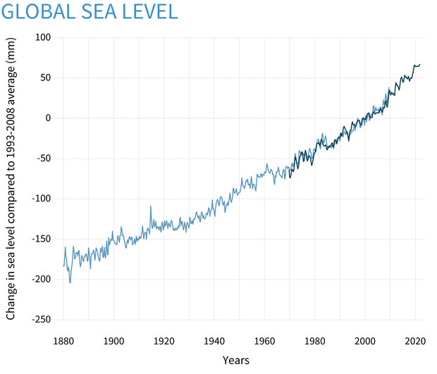
Published in Talanta, the research opens up potential for new environmental applications of the method, such as tracing the effect of sea level rise, including detection of seawater intrusion into freshwater systems.

“Sulfur isotopes can tell us a great deal about Earth cycles both now and in the past,” said lead author PhD student Emily Leyden from the University of Adelaide’s School of Biological Sciences.

“Different water sources have different levels of sulfur isotopes within them. The processes that occur within an environment such as the intrusion of seawater into freshwater systems, and oxidation of acid sulfate soils, can change these ratios. By analysing sulfur isotope ratios we can gain important insights into how environments are changing.”

The traditional method of measuring sulfur isotopes is known as mass spectroscopy (MS), where samples are ionized (split into their ions) and the ions of interest in the samples are measured depending on their mass to charge ratio, which differs between isotopes of the same chemical element.

The traditional method has been notoriously difficult, as the mass to charge ratio amongst ions can disperse and overlap, which can make the results hard to differentiate. Sulfur can usually only be measured reliably if there is complex chemical purification before analysis, which is time consuming, difficult and expensive.

As part of Ms Leyden’s PhD study, a team including members from the University of Adelaide’s Metal Isotope Group with the School of Physical Sciences, the School of Biological Sciences and Adelaide Microscopy, with scientists at Flinders University, worked together to develop a novel method to measure sulfur isotopes using an inductively coupled plasma (ICP) MS instrument.

The new instrument enabled the team to solve the overlapping issue (known as spectral interference) by combining sulfur with another element (oxygen in this case) to increase the mass to charge ratio in order to lower the risk of spectral interference. The sulfur isotopes can then be measured accurately without the need for complex and time consuming sample purification.

In the study, the University of Adelaide scientists simulated how the method would work in a real world scenario by tracing seawater flooding into a range of different coastal environments in South Australia.

Following flooding, the original sulfur isotope of the soil water clearly changed to that of the seawater isotope. The sulfur isotope ratios of the samples also gave clues to their individual and unique makeup before seawater flooding. For example, acid sulfate soil impacts were detected in two soils, and the signature of historical upstream silver sulfide mining could be detected from a site in the upper Onkaparinga River.

Co-author and Principal PhD Supervisor Associate Professor Luke Mosley from the University of Adelaide’s Environment Institute and School of Biological Sciences says, the new method opens up sulfur isotope measurement to a range of new environmental applications for scientists across many different disciplines.

University of Adelaide scientists have developed a new simple, inexpensive and fast method to analyse sulfur isotopes, which can be used to help investigate chemical changes in environments such as oceans, and freshwater rivers and lakes.

Published in Talanta, the research opens up potential for new environmental applications of the method, such as tracing the effect of sea level rise, including detection of seawater intrusion into freshwater systems.

“Sulfur isotopes can tell us a great deal about Earth cycles both now and in the past,” said lead author PhD student Emily Leyden from the University of Adelaide’s School of Biological Sciences.

“Different water sources have different levels of sulfur isotopes within them. The processes that occur within an environment such as the intrusion of seawater into freshwater systems, and oxidation of acid sulfate soils, can change these ratios. By analysing sulfur isotope ratios we can gain important insights into how environments are changing.”

The traditional method of measuring sulfur isotopes is known as mass spectroscopy (MS), where samples are ionized (split into their ions) and the ions of interest in the samples are measured depending on their mass to charge ratio, which differs between isotopes of the same chemical element.

The traditional method has been notoriously difficult, as the mass to charge ratio amongst ions can disperse and overlap, which can make the results hard to differentiate. Sulfur can usually only be measured reliably if there is complex chemical purification before analysis, which is time consuming, difficult and expensive.

As part of Ms Leyden’s PhD study, a team including members from the University of Adelaide’s Metal Isotope Group with the School of Physical Sciences, the School of Biological Sciences and Adelaide Microscopy, with scientists at Flinders University, worked together to develop a novel method to measure sulfur isotopes using an inductively coupled plasma (ICP) MS instrument.

The new instrument enabled the team to solve the overlapping issue (known as spectral interference) by combining sulfur with another element (oxygen in this case) to increase the mass to charge ratio in order to lower the risk of spectral interference. The sulfur isotopes can then be measured accurately without the need for complex and time consuming sample purification.

In the study, the University of Adelaide scientists simulated how the method would work in a real world scenario by tracing seawater flooding into a range of different coastal environments in South Australia.

Following flooding, the original sulfur isotope of the soil water clearly changed to that of the seawater isotope. The sulfur isotope ratios of the samples also gave clues to their individual and unique makeup before seawater flooding. For example, acid sulfate soil impacts were detected in two soils, and the signature of historical upstream silver sulfide mining could be detected from a site in the upper Onkaparinga River.

Co-author and Principal PhD Supervisor Associate Professor Luke Mosley from the University of Adelaide’s Environment Institute and School of Biological Sciences says, the new method opens up sulfur isotope measurement to a range of new environmental applications for scientists across many different disciplines.

“Using this new method, scientists can measure sulfur isotopes in environmental samples easily following only simple dilution of the sample of interest,” said Associate Professor Mosley.

“It is particularly timely and important given there is rapid global environmental change, and the method enables easier detection of seawater intrusion into freshwater systems due to sea-level rise.”

FOR MORE INFORMATION: https://www.sciencedaily.com/releases/2021/08/210803105512.htm

Improving the estimation of microplastic concentrations in freshwater environments

The extent of plastic pollution remains largely hidden from view in the form of microplastics (MPs): plastic particles with diameters less than 5 mm. Since plastics are slow to degrade, they fragment into tiny particles that end up contaminating entire ecosystems. In the years since their discovery in the early 1970s, MPs have become a ubiquitous and global concern. MPs are found in land, air, water, and the food that we eat, especially seafood. This is because freshwater sources, such as rivers, often carry off MPs into the oceans, where they accumulate.

Despite its pervasiveness, however, there is currently no standard procedure to measure and quantify MP concentration in rivers. Plankton nets, originally designed to collect plankton samples, are commonly used to capture MPs in rivers. To prevent these nets from getting clogged and ensure a large sample size, multiple samples are collected at fixed locations along the river and the MP concentration is calculated as the average of all the sampling results. Most studies, however, do not take uncertainties and sampling errors into account, resulting in an erroneous assessment of MP concentrations, particularly in terms of the amounts of samples required for accurate MP assessments.

Now, in a recent study published in Environmental Pollution, Dr. Mamoru Tanaka and Professor Yasuo Nihei from Tokyo University of Science along with Associate Professor Tomoya Kataoka from Ehime University in Japan have improved upon the estimation of the MP concentration by accounting for the variability between estimations obtained from different samples. The variance can help estimate the appropriate number of samples required for an accurate representation of MP contamination. “For an on-site sampling of microplastics, we have proposed a method for determining the appropriate number of iterations in each contamination situation,” says Dr. Tanaka.

Additionally, the variance can provide insight into how MPs are distributed in the waterbody. For instance, if they are uniformly distributed in the river, the variances between the samples would be low. On the other hand, a high variance would indicate a non-uniform clumped distribution.

To evaluate the inter-sample variances in MP concentration, the scientists borrowed another method originally intended for zooplankton. “It turns out that the numerical concentration ranges of riverine microplastics overlap with those of zooplankton,” explains Dr. Tanaka, regarding the similarity of both the sampling procedure and the concentration estimations between MPs and zooplankton. According to this method, the inter-sample variance is proportional to the average or mean of the concentration estimations.

For the MP concentrations, the team collected 10 samples in plankton nets at two sites along the Ohori River and Tone-unga (Unga) canal in Chiba, Japan — two waterbodies that flow through urban areas and contain a high concentration of plastic waste. They identified a total of 1333 MP particles at the sampling sites. The average concentrations of the MPs, which were measured to be 5.23 particles/m3 in the Ohori and 15.22 particles/m3 in the Unga, were higher than the reported average of MPs in Japanese rivers (4.3 particles/m3). Furthermore, the calculated averages and variance at both locations matched up with a simple linear regression. “Variance steadily increased with an increase in the mean numerical concentrations,” points out Dr. Tanaka. Regression analysis further suggested that the MPs in the rivers do not interact with one another, resulting in random particle distributions.

Most importantly, the team found that at high MP concentrations, two replicate samples are sufficient to measure the MP concentrations accurately. “We found that the mean of two replicates maintained sufficient precision of less than 30% for conditions with high concentrations of more than 3 particles/m3,” says Dr. Tanaka.

The problem of MPs has been recognized in recent years and various countries including Japan have passed legislation to ensure better monitoring and control of MPs in the environment. In this light, this study could help improve the sampling methodology, reducing the time and resources invested in MP assessment surveys.

make a difference: sponsored opportunity

FOR MORE INFORMATION: https://www.sciencedaily.com/releases/2022/08/220810105114.htm

Natural clean-up: Bacteria can remove plastic pollution from lakes

A study of 29 European lakes has found that some naturally-occurring lake bacteria grow faster and more efficiently on the remains of plastic bags than on natural matter like leaves and twigs.

The bacteria break down the carbon compounds in plastic to use as food for their growth.

The scientists say that enriching waters with particular species of bacteria could be a natural way to remove plastic pollution from the environment.

The effect is pronounced: the rate of bacterial growth more than doubled when plastic pollution raised the overall carbon level in lake water by just 4%.

The results suggest that the plastic pollution in lakes is ‘priming’ the bacteria for rapid growth — the bacteria are not only breaking down the plastic but are then more able to break down other natural carbon compounds in the lake.

Lake bacteria were found to favour plastic-derived carbon compounds over natural ones. The researchers think this is because the carbon compounds from plastics are easier for the bacteria to break down and use as food.

The scientists caution that this does not condone ongoing plastic pollution. Some of the compounds within plastics can have toxic effects on the environment, particularly at high concentrations.

The findings are published today in the journal Nature Communications.

“It’s almost like the plastic pollution is getting the bacteria’s appetite going. The bacteria use the plastic as food first, because it’s easy to break down, and then they’re more able to break down some of the more difficult food — the natural organic matter in the lake,” said Dr Andrew Tanentzap in the University of Cambridge’s Department of Plant Sciences, senior author of the paper.

He added: “This suggests that plastic pollution is stimulating the whole food web in lakes, because more bacteria means more food for the bigger organisms like ducks and fish.”

The effect varied depending on the diversity of bacterial species present in the lake water — lakes with more different species were better at breaking down plastic pollution.

A study published by the authors last year found that European lakes are potential hotspots of microplastic pollution.

When plastics break down they release simple carbon compounds. The researchers found that these are chemically distinct to the carbon compounds released as organic matter like leaves and twigs break down.

The carbon compounds from plastics were shown to be derived from additives unique to plastic products, including adhesives and softeners.

The new study also found that bacteria removed more plastic pollution in lakes that had fewer unique natural carbon compounds. This is because the bacteria in the lake water had fewer other food sources.

The results will help to prioritise lakes where pollution control is most urgent. If a lake has a lot of plastic pollution, but low bacterial diversity and a lot of different natural organic compounds, then its ecosystem will be more vulnerable to damage.

“Unfortunately, plastics will pollute our environment for decades. On the positive side, our study helps to identify microbes that could be harnessed to help break down plastic waste and better manage environmental pollution,” said Professor David Aldridge in the University of Cambridge’s Department of Zoology, who was involved in the study.

The study involved sampling 29 lakes across Scandinavia between August and September 2019. To assess a range of conditions, these lakes differed in latitude, depth, area, average surface temperature and diversity of dissolved carbon-based molecules.

The scientists cut up plastic bags from four major UK shopping chains, and shook these in water until their carbon compounds were released.

At each lake, glass bottles were filled with lake water. A small amount of the ‘plastic water’ was added to half of these, to represent the amount of carbon leached from plastics into the environment, and the same amount of distilled water was added to the others. After 72 hours in the dark, bacterial activity was measured in each of the bottles.

The study measured bacterial growth — by increase in mass, and the efficiency of bacterial growth — by the amount of carbon-dioxide released in the process of growing.

In the water with plastic-derived carbon compounds, the bacteria had doubled in mass very efficiently. Around 50% of this carbon was incorporated into the bacteria in 72 hours.

“Our study shows that when carrier bags enter lakes and rivers they can have dramatic and unexpected impacts on the entire ecosystem. Hopefully our results will encourage people to be even more careful about how they dispose of plastic waste,” said Eleanor Sheridan in the University of Cambridge’s Department of Plant Sciences, first author of the study who undertook the work as part of a final-year undergraduate project.

FOR MORE INFORMATION: https://www.sciencedaily.com/releases/2022/07/220726132524.htm

Oft-overlooked grasslands build biodiversity, resilience over centuries

Grasslands’ biodiversity and resilience to disturbances such as fire, heat and drought is the result of a slow process over hundreds of years, like that of old growth forests, finds new University of Colorado Boulder-led research.

Publishing in the journal Science on Aug. 5, 2022, as part of a special issue on grasslands, the study contradicts years of assumptions that grasslands’ ecological development is quick and their recovery is rapid, posing new challenges to their successful restoration.

“Old growth grasslands have a unique suite of characteristics that develop over a really long time. Recovering grasslands do not have the same species or the same characteristics as they did prior to soil tilling or tree planting, and they take centuries to redevelop,” said Katharine Suding, senior author of the paper and Distinguished Professor in the Department of Ecology and Evolutionary Biology and Institute of Arctic and Alpine Research (INSTAAR) at CU Boulder. “It’s an important reminder that we need to conserve the ancient grasslands that are still intact.”

An expert in the field of North American grasslands, Suding partnered with other experts from around the world to evaluate the current state of global grassland science, conservation and restoration — from arid, prairie and coastal grasslands, to those in the tropics and savannahs.

Grasslands, which account for nearly 40% of land-based ecosystems, provide habitat for a wide diversity of animals and plants, and contribute to the livelihoods of over 1 billion people worldwide. They also provide significant carbon sequestration and biodiversity benefits, and can be more resilient than forests in the face of a quickly changing climate.

Yet over the past couple of centuries, ancient grasslands around the world have largely been converted into farmland, used to grow trees or been developed as cities expand.

The researchers found that while the destruction of these pristine grasslands can occur very quickly, complete recovery of grassland biodiversity and essential ecosystem functions occurs slowly or not at all. The findings further emphasize the importance of conserving the world’s remaining untouched grasslands.

“If you plant trees in an older grassland or till it for agriculture, you will probably never get many of the unique diversity and belowground characteristics back. It is irreversible,” said Suding.

Restoration takes time 

Grasslands store the bulk of their material underground, in roots that can reach as far as 20 feet deep. This unseen physical presence is how they can store a lot of carbon — about a third of all carbon stored on land — and remain resilient to fire and other ecological disturbances. It’s also why grasslands are often underappreciated in comparison to forests. If it’s out of sight, it’s out of mind.

Grassland restoration, however, can take a page out of forests’ playbook.

“‘Old growth’ is not only a term for forests, but one that applies to grasslands as well,” said co-author Elise Buisson, who co-authored that finding in a 2015 publication.

Old growth grasslands are unique in their underground structures and biodiversity compared to newer, younger grasslands. And while these old growth ecosystems may never be fully replicated in modern-day landscapes, they provide a model for restoration efforts, said Suding.

Even a decade ago, grassland restoration focused on distributing species’ seed onto a landscape, adding grazing or fire, and stepping aside. The new analysis finds that it takes more than a hands-off approach to be successful. Instead of tossing all the ingredients into a crockpot and turning it on high, grasslands may need more of a step-by-step recipe approach to restoration.

“We should think of restoration as more of guiding a trajectory. Some species don’t come in right at the start, and the disturbance that maintains the grassland needs time to grow and be tweaked as these species get established and the soil develops,” said Suding. “These processes take time.”

For example, some plants do well reproducing from seed in, say, the upper Midwest but not in Colorado due to the drier climate. Many tropical grasses don’t spread by seed at all, instead by rhizomes and tubers underground, and are much more difficult to reestablish.

Implications for policy

The report comes a year after the start of the United Nations Decade on Ecosystem Restoration, which aims to restore degraded ecosystems around the world to increase biodiversity, help achieve the Sustainable Development Goals and the Paris Climate Agreement. At the same time, planting trees has become a popular “natural solution” around the world to remove large quantities of carbon from the atmosphere.

Yet while the UN initiative explicitly states, “planting trees on natural grassland may destroy more than it creates,” as countries make ambitious goals and commitments to ecosystem restoration this decade, Suding worries that for many, this only means planting trees.

“We would lose a huge element of the biodiversity on Earth if we planted trees in old growth grasslands,” said Suding. “I think we need to be a little bit more careful about what’s best for the globe, in terms of where to restore what.”

As climate change threatens the American West through drought, heat and wildfire, grasslands are also a resilient choice to use less water, reduce soil erosion and keep carbon in the ground over time. It’s the older, veteran grasslands that are most beneficial in this regard.

“They’re very resilient to a lot of these threats that we’re increasingly experiencing. Grasslands are resilient and can deliver well in terms of our priorities of carbon storage, water infiltration and soil health,” said Suding.

FOR MORE INFORMATION:https://www.sciencedaily.com/releases/2022/08/220805091224.htm

Importance of good water quality

National Water Quality Month was originally founded in 2005 by the Environmental Protection Agency (EPA) but has a long history of support prior to its founding. Public support goes all the way back to the early 1970s, when initiatives for the Clean Water Act first began. After being passed in 1972, the Clean Water Act made it illegal to dump large amounts of toxic materials into water bodies. A little later, the Safe Drinking Water Act was passed in 1974 to protect the public water systems and groundwater supply. Today, the Clean Water Act, the Safe Drinking Water Act, the EPA, and water utility companies all play an important part in making sure that our water is safe to use.

Humans are not the only ones that benefit from good water quality; countless fish, animals and plants need good, clean water to thrive and survive. Consider the ongoing tragedy of the West Indian Manatees of Florida. These iconic mammals, already on the endangered list, have lost huge areas of prime seagrass that they rely on for grazing due to harmful algae blooms that block sunlight from reaching the seagrasses. The algae blooms are caused by increased water pollution and higher water temperatures. Over 475 manatees died of starvation just this year from January to March from habitat loss. This tragic loss could have been prevented by better water quality.

There’s no one source to blame for the deterioration of water quality; thousands of factors impact the quality of local waters, but there are ways that we can all pitch in to do our part and help out. Picking up after your pets, washing your car on grass or in car washes rather than the driveway, pick up and bag trash, don’t over fertilize your yard, keep your car well maintained and serviced, and becoming informed about water quality rules and regulations locally are all ways that we can each get involved in supporting the quality of our water supply.

FOR MORE INFORMATION: https://www.delgazette.com/opinion/97827/importance-of-good-water-quality

Polluted, drained, and drying out: new warnings on New Zealand’s rivers and lakes

The latest environmental report on New Zealand’s lakes and rivers reiterates bleak news about the state of freshwater ecosystems, and warns that climate change will exacerbate existing threats.

Almost all New Zealand rivers running through urban and farming areas (95-99%) carry pollution above water quality guidelines, while most of the nation’s wetlands (90%) have been drained, and many freshwater fish species (76%) are threatened or at risk. 

The most significant pressures on freshwater ecosystems fit into four issues:

What whitebait tell us about freshwater fish under stress

The latest assessment is an update on a freshwater report in 2017and the comprehensive Environment Aotearoa 2019. It reiterates issues we’ve seen before, but begins to implement recent recommendations by the Parliamentary Commissioner for the Environment (PCE) calling for a stronger link between data and environmental management.

Biological impacts are at the forefront of this latest assessment. It shows that a wide range of freshwater organisms are at risk. The statistics for freshwater fish are the most concerning, with three quarters of the 51 native species already either threatened or at risk of extinction. 

The report uses a particular group of native fish (īnanga, or galaxids) to connect the multiple impacts humans have, across a range of habitats at different life stages. 

Īnanga are better known as whitebait, a delicacy that is a mix of juveniles from six different species caught as they migrate from the sea to rivers.

Īnanga of different ages and species live in different habitats, so they can be used to represent the issues facing a range of freshwater fish across ecosystems. The main stress factors include altered habitat, pollution and excess nutrients, water use for irrigation and climate change. 

Climate change is expected to exacerbate existing stresses native organisms like īnanga face and protecting their habitat means understanding how much it will reduce water flows and create hotter and drier conditions. 

Filling gaps in understanding

The use of organisms to assess environmental change, including climate change impacts, is an obvious but important step. It makes it possible to consider climate change in a way that meets the Environmental Reporting Act’s requirement to report on a “body of evidence”. 

This latest report responds to the PCE’s concerns about gaps in our knowledge, which were raised in the Environment Aotearoa 2019 assessment. The new strategy for filling large holes in our knowledge has three priorities: knowing and monitoring what we have, what we may lose, and where or how we can make changes. 


Read more: Six ways to improve water quality in New Zealand’s lakes and rivers


The report highlights that mātauranga Māori, the process of using indigenous knowledge about the environment, can fill some gaps in data or add insights. Other methods and models, such as nutrient budget scenarios, also deserve consideration. 

There is some good news as well. Some pollution concerns may be minor or limited to very small areas. This includes several so-called emerging contaminants, such as fire retardants, which have been discovered in groundwater around airfields but are now banned or restricted. 

The second piece of good news is that new ways of studying the environment can help fill major gaps. For example, lakes may be more stable indicators of freshwater health than rivers and streams, but only 4% (about 150) of New Zealand’s 3,820 larger lakes are regularly monitored by regional councils. 

For almost 300 lakes, the report includes an index of the plants that live in them, and for more than 3000 there is now an established method of estimating lake water quality. Further information is becoming available, using updated estimations, satellite data for the last 20 years and sediment cores to reconstruct environmental conditions over the last few hundred years.

Unfortunately, the data from lakes confirms the general trend of freshwater decline, but at least the multiple forms of complementary information should help us to manage New Zealand’s freshwater ecosystems better.

FOR MORE INFORMATION:https://theconversation.com/polluted-drained-and-drying-out-new-warnings-on-new-zealands-rivers-and-lakes-136486

Water wells are at risk of going dry in the US and worldwide

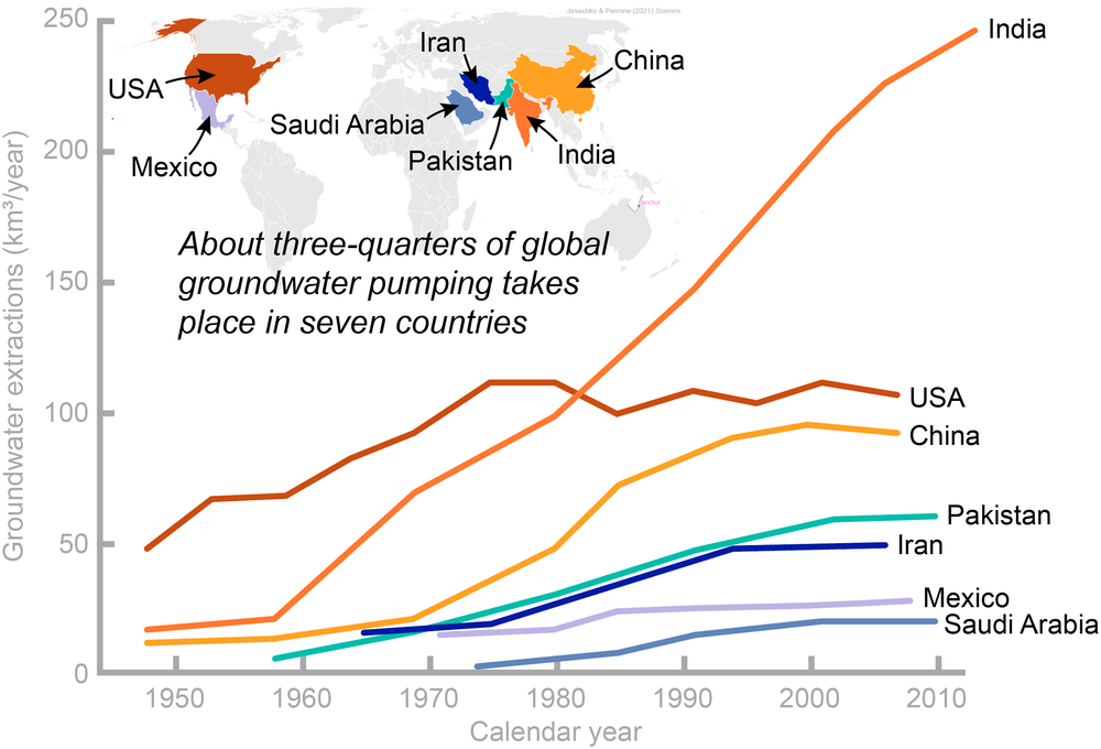
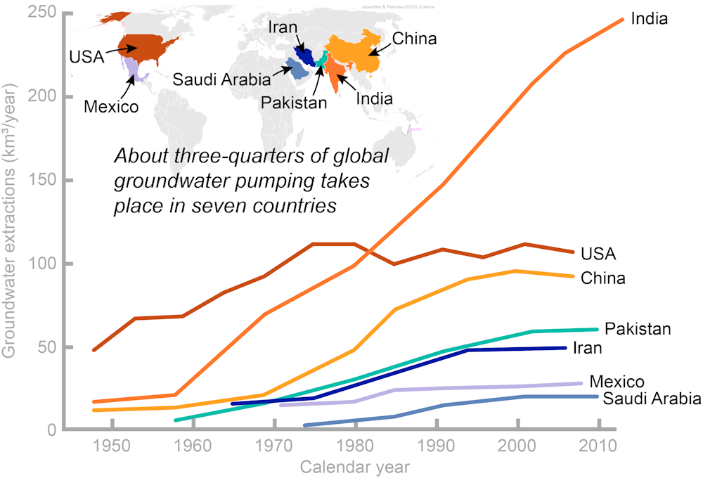
As the drought outlook for the Western U.S. becomes increasingly bleak, attention is turning once again to groundwater – literally, water stored in the ground. It is Earth’s most widespread and reliable source of fresh water, but it’s not limitless.

Wells that people drill to access groundwater supply nearly half the water used for irrigated agriculture in the U.S. and provide over 100 million Americans with drinking water. Unfortunately, pervasive pumping is causing groundwater levels to decline in some areas, including much of California’s San Joaquin Valleyand Kansas’ High Plains.

We are a water resources engineer with training in water law and a water scientist and large-data analyst. In a recent study, we mapped the locations and depths of wells in 40 countries around the world and found that millions of wells could run dry if groundwater levels decline by only a few meters. While solutions vary from place to place, we believe that what’s most important for protecting wells from running dry is managing groundwater sustainably – especially in nations like the U.S. that use a lot of it.

Groundwater use today

Humans have been digging wells for water for thousands of years. Examples include 7,400-year-old wells in the Czech Republic and Germany, 8,000-year-old wells in the eastern Mediterranean, and 10,000-year-old wells in Cyprus. Today wells supply 40% of water used for irrigation worldwide and provide billions of people with drinking water. 

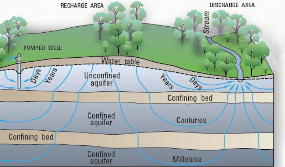
Groundwater flows through tiny spaces within sediments and their underlying bedrock. At some points, called discharge areas, groundwater rises to the surface, moving into lakes, rivers and streams. At other points, known as recharge areas, water percolates deep into the ground, either through precipitation or leakage from rivers, lakes and streams.

Pumping can remove groundwater from underground faster than it recharges.

Groundwater declines can have many undesirable consequences. Land surfaces sink as underground clay layers are compacted. Seawater intrusion can contaminate groundwater reserves and make them too salty to use without energy-intensive treatment. River water can leak down to underground aquifers, leaving less water available at the surface.

Groundwater depletion can also cause wells to run dry when the top surface of the groundwater – known as the water table – drops so far that the well isn’t deep enough to reach it, leaving the well literally high and dry. Yet until recently, little was known about how vulnerable global wells are to running dry because of declining groundwater levels. 

There is no global database of wells, so over six years we compiled 134 unique well construction databases spanning 40 different countries. In total, we analyzed nearly 39 million well construction records, including each well’s location, the reason it was constructed and its depth. 

Our results show that wells are vital to human livelihoods – and recording well depths helped us see how vulnerable wells are to running dry.

Millions of wells at risk

Our analysis led to two main findings. First, up to 20% of wells around the world extend no more than 16 feet (5 meters) below the water table. That means these wells will run dry if groundwater levels decline by just a few feet.

Second, we found that newer wells are not being dug significantly deeper than older wells in some places where groundwater levels are declining. In some areas, such as eastern New Mexico, newer wells are not drilled deeper than older wells because the deeper rock layers are impermeable and contain saline water. New wells are at least as likely to run dry as older wells in these areas. 

Wells are already going dry in some locations, including parts of the U.S. West. In previous studies we estimated that as many as 1 in 30 wells were running dry in the western U.S., and as many as 1 in 5 in some areas in the southern portion of California’s Central Valley. 

Households already are running out of well water in the Central Valley and southeastern Arizona. Beyond the Southwest, wells have been running dry in states as diverse as Maine, Illinois and Oregon.

FOR MORE INFORMATION: https://theconversation.com/water-wells-are-at-risk-of-going-dry-in-the-us-and-worldwide-160147

First solar canal project is a win for water, energy, air and climate in California

First solar canal project is a win for water, energy, air ...

Mounting evidence suggests the western United States is now in its worst megadrought in at least 1,200 years. Groundwater supplies are being overpumped in many places, and the dryness, wildfires and shrinking water supplies are making climate changepersonal for millions of people.

As an engineer, I have been working with colleagues on a way to both protect water supplies and boost renewable energy to protect the climate.

We call it the solar-canal solution, and it’s about to be tested in California.

About 4,000 miles of canals transport water to some 35 million Californians and 5.7 million acres of farmland across the state. As we explained in a 2021 study, covering these canals with solar panels would reduce evaporation of precious water – one of California’s most critical resources – and help meet the state’s renewable energy goals, while also saving money.

We bring the expertise of academics to the public.

About our team

The first prototypes in the U.S. for both wide-span and narrow-span canals are now in development in California’s Central Valley. Researchers at the University of California, Merced, are involved in the project, and we will be trying to determine how this can become a large-scale solution.

Conserving water and land

California is prone to drought, and water is a constant concern. Now, the changing climate is bringing hotter, drier weather. 

Severe droughts over the past 10 to 30 years dried up wells, caused officials to implement water restrictions and fueled massive wildfires.

At the same time, California has ambitious conservation goals. The state has a mandate to reduce groundwater pumping while maintaining reliable supplies to farms, cities, wildlife and ecosystems. As part of a broad climate change initiative, in October 2020 Gov. Gavin Newsom directed the California Natural Resources Agency to spearhead efforts to conserve 30% of land and coastal waters by 2030. 


Read more: California’s water supplies are in trouble as climate change worsens natural dry spells, especially in the Sierra Nevada


Most of California’s rain and snow falls north of Sacramento during the winter, while 80% of its water use occurs in Southern California, mostly in summer. That’s why canals snake across the state – it’s the largest such system in the world. We estimate that about 1%-2% of the water they carry is lost to evaporation under the hot California sun.

In a 2021 study, we showed that covering all 4,000 miles of California’s canals with solar panels would save more than 65 billion gallons of water annually by reducing evaporation. That’s enough to irrigate 50,000 acres of farmland or meet the residential water needs of more than 2 million people. By concentrating solar installations on land that is already being used, instead of building them on undeveloped land, this approach would help California meet its sustainable management goals for both water and land resources.

FOR MORE INFORMATION: https://theconversation.com/first-solar-canal-project-is-a-win-for-water-energy-air-and-climate-in-california-177433

Water Quality Affecting Dairy Farming

Water scarcity and water pollution are increasingly critical global issues. Water scarcity is driven not only by shortages of water, but also by rendering water unusable through pollution. New Zealand is no exception to these trends.

Demand for water has rapidly increased, and New Zealand now has the highest per capita take of water for agriculture among OECD countries. Regulatory failures have also led to over-allocation of many ground and surface water resources.

Some water sources are also well on the way to being unusable. Over the past few decades, nutrient and sediment emissions into waterways have increased, driven by agricultural and horticultural intensification.

Much is made of the environmental benefits of New Zealand’s “grass-fed” dairy systems. But a major downside of high-intensity outdoor farming systems is the nitrate leaching from animal waste and synthetic fertilisers that contaminates fresh water.

The Conversation is a news organization dedicated to facts and evidence

Learn more

Milk’s grey water footprint

Our new paper focuses on nitrate pollution in Canterbury. We comprehensively quantify, for the first time, the nitrate “grey water” footprint of milk production in the region.

A water footprint (WF) is a measure of the volume of fresh water used to produce a given mass or volume of product (in this case, milk).

It’s made up of both “consumptive” and “degradative” components. The consumption component is rainwater (green WF) and groundwater or surface water (blue WF) used in irrigation. 

Most water footprint studies of food systems highlight the consumptive water component and often neglect the degradative component. However, we found Canterbury’s pasture-based systems mean grey water is the biggest component.

FOR MORE INFORMATION: https://theconversation.com/11-000-litres-of-water-to-make-one-litre-of-milk-new-questions-about-the-freshwater-impact-of-nz-dairy-farming-183806

Audit: California too slow to fix contaminated water systems

SACRAMENTO, Calif. (AP) — The water that comes out of the tap for more than 900,000 Californians is unsafe to drink and the state isn’t acting fast enough to help clean it up, state auditors said in a report released Tuesday.

Thousands of water systems supply the state’s 39 million people, and about 5% of them have some type of contaminant, like nitrates or arsenic, in them, according to the audit. That means people can’t safely drink the water or use it to cook or bathe. Most of the 370 failing systems are in economically disadvantaged communities, many in the Central Valley, the state’s agricultural heartland. 

The State Water Resources Control Board has provided at least $1.7 billion in grants since 2016 for design and construction to improve water systems. That could include building new treatment plants, consolidating water systems or other actions designed to improve water quality. 

But it took the board 33 months on average in 2021 for water system operators to complete the application process and receive money, the audit found — nearly double the time it took in 2017. The audit found a lack of clear metrics and poor communication created confusion for water districts seeking help and slowed down the award process. 

“The longer the board takes to fund projects, the more expensive those projects become. More importantly, delays increase the likelihood of negative health outcomes for Californians served by the failing water systems,” acting state auditor Michael Tilden wrote in a letter to the Legislature.

Eileen Sobeck, executive director for the water board, told state auditors the board agrees the process could be clearer and faster. But she disagreed with the conclusion that the board hasn’t acted with urgency to improve contaminated water systems, saying the board’s “highest priority is advancing the human right to water.” California made a right to safe drinking water state law in 2013. The water board has previously said it would need $4.5 billion to address all the needs through 2025.

She said the state has reduced the number of people who rely on contaminated water from 1.6 million in 2019 to less than 1 million today. It’s also provided $700 million in grants to water systems. It’s helped pay for construction projects in 90 communities, consolidation of 73 water systems, and begun streamlining the application process, she said.

E. Joaquin Esquivel, chair of the water board, said the audit’s finding that the board lacks urgency in addressing the problem is “salacious” but doesn’t reflect the “tremendous amount of progress” the board has made in helping water systems.

The state sets requirements for more than 100 water contaminants, including nitrate, arsenic and E. coli, limiting the amount that can be in water. Some, like nitrates, come from excess fertilizer used by agriculture. Different contaminants can cause respiratory problems for infants, harm the liver and kidneys, and increase the risk of cancer. Even when water isn’t safe to drink, people still have to pay the water bill, plus the added cost of buying bottled water or hauling it in from elsewhere.

ADVERTISEMENT

“Just because you’re not drinking from the tap doesn’t mean you don’t have to pay for the access,” said Kyle Jones, policy and legal director for the Community Water Center, which works to expand access to clean water.

Gov. Gavin Newsom, a Democrat, created a $130 million fund in 2019 to improve drinking water systems, particularly those that serve low-income communities. At the time, he called it a “moral disgrace” that Californians couldn’t rely on clean water to drink or bathe. His office didn’t respond to an email Tuesday seeking comment on the audit. 

In one example of the slow process, the audit found the water board wasn’t checking in enough on a technical assistance project for a water system in Kern County. Ten months after the board had assigned a provider to help the district, no work had been completed, causing the board to look for another provider. In another case, it took the water board 14 months to figure out whether a water district in rural Northern California was eligible for grant funding to improve its drinking and wastewater. 

Water districts that took a survey from the auditor called the board’s application process a “nightmare” filled with red tape and unclear expectations.

Michael Claiborne, directing attorney for Leadership Council for Justice and Accountability, said many Californians have been fighting for decades for clean water to no avail. 

His organization advocates for safe and affordable drinking water access for communities in the San Joaquin Valley and east Coachella Valley, and it has been hired as a legal and technical consultant for some of the projects that receive board funding. As both an advocate and a contractor on some projects, he agreed with the audit’s findings that the board needs clear metrics to access its progress and set expectations.

But he said local governments need to step up as well, as they can delay projects to consolidate water systems or begin new construction.

“Without cooperation from local governments and local water systems, you can’t implement solutions,” he said.

FOR MORE INFORMATION:https://apnews.com/article/health-california-water-quality-climate-and-environment-ca8eb802e95e8704ca0038d718fad541