Tens of millions of Americans live in areas vulnerable to hurricanes and tropical storms, many of whom are far from the coast. Flooding caused by these storms sometimes lasts weeks after they pass, often occurring hundreds of miles inland from where the storm made landfall.
Knowing where flooding is occurring, how significant it might be, and where waters are rising is critical information used to help protect people and communities. The U.S. Geological Survey provides this vital flood data via a nationwide network of more than 11,000 permanent streamgages installed along rivers, streams, lakes, and reservoirs. The USGS also has a smaller network of tide gauges that monitor tidally influenced bodies of water in select parts of the country.
The USGS streamgage network is one of the largest in the world and provides near real-time water levels and flows year-round at many key locations across the nation. USGS stream and tide gauge data on water levels and flows can play a crucial role in shaping critical decisions such as evacuation plans by emergency managers, coastal and inland flood forecasts by the National Weather Service, and flood-control decisions by the U.S. Army Corps of Engineers. The information gained from each storm also improves scientific understanding of storms and advances the USGS’s ability to inform decisions. This can help increase preparedness, reduce risk and enhance resilience for communities potentially affected by hurricanes and tropical storms.
Data from the stream and tide gauge networks are available online on the USGS National Water Dashboard. In addition to stream and tide gauge data, this interactive website also delivers real-time precipitation, atmospheric, water-quality and groundwater data from more than 16,000 USGS observation stations across the country.
To better track flooding events – like those often associated with hurricanes and tropical storms – in areas not monitored year-round by streamgages, the USGS utilizes specialized devices called “rapid deployment gauges.” As the name suggests, these temporary gauges can be installed quickly at critical locations to augment the USGS’s nationwide streamgage network.
Rapid deployment gauges provide near real-time information to the public and emergency managers tracking floodwaters. This can include data on water levels, precipitation, wind speed, temperature, humidity and barometric pressure, and are available on the USGS Flood Event Viewer. This online tool displays rapid deployment gauge locations and data for current and past events.
Come back next week to learn how hurricanes and tropical storms can spread invasive plants and animals through floodwaters and how the USGS estimates their potential spread.
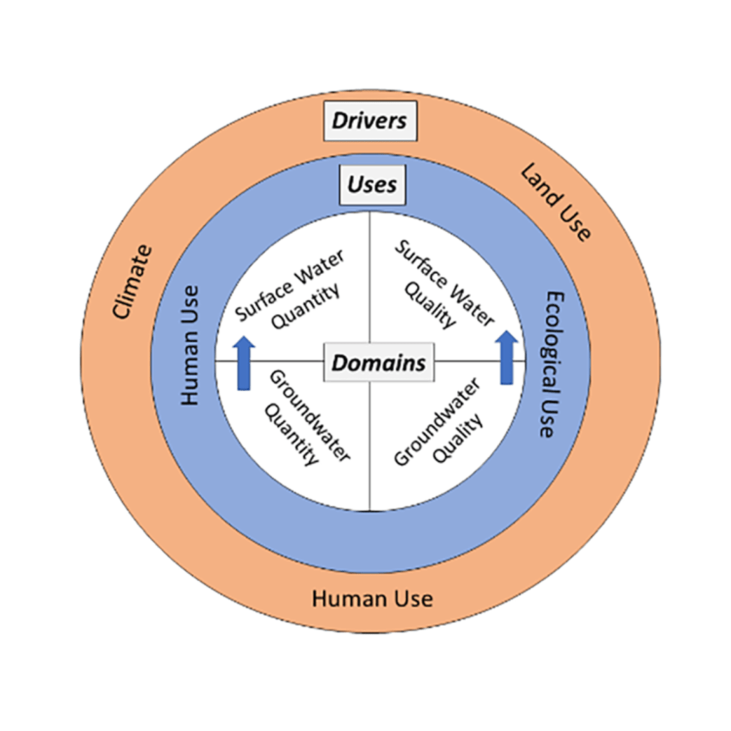
Water resources sustain human development and aquatic ecosystems, but water scarcity is a global issue. Changes in water resource availability such as reduced streamflow or depleted groundwater can cause tension between human water use and ecological needs.Water managers hold a lot of responsibility in balancing these needs, and they rely on our data to make well-informed decisions. At USGS, we detect and quantify changes in water resources. We also have a role to advance understanding of the drivers responsible for those changes. So, we conduct trend studies, which document historical changes in data over time. Trend studies provide essential information to guide water resources management.Water managers need to know the effects of land use, water use, and climate change so they can effectively design water management strategies that better address human and ecosystem needs. In this recently released publication, our scientists outlined the current state of national water availability trend assessments and evaluated ways to advance future trend assessments. They concluded that additional capabilities must be developed and integrated into the assessments. Our scientists recommend potential solutions that could improve the management of water resources:
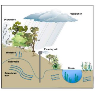
timely and efficient delivery of trend results the capability to estimate trends in ungaged areas increased understanding of groundwater-surface water interactions better quantification of water use for human needs explicit representation of ecological flow requirements
Our scientists also identified ways researchers could improve the design of the assessments. Researchers need methods to account for how changes in quality affect water supply estimates. They also need methods to develop improved datasets which would distinguish the interrelated impacts of land use, human water use, and climatic influences.
By: GFZ GeoForschungsZentrum Potsdam, Helmholtz Centre
An El Niño event has officially begun. The climate phenomenon, which originates in the tropical Pacific and occurs in intervals of a few years will shape weather across the planet for the next year or more and give rise to various climatic extremes. El Niño-like conditions can also occur on longer time scales of decades or centuries. This has been shown to have occurred in the recent past by an international research team led by Ana Prohaska of the University of Copenhagen and Dirk Sachse of the German Research Centre for Geosciences (GFZ). Their analysis of biomarkers — organic molecules or molecular fossils from vascular plants — in the sediments of a lake in the Philippines indicates an unusually dry phase in the region during the Little Ice Age between 1600 and 1900 A.D. The results have now been published in the journal Communications Earth and Environment. They show how important the understanding of past dynamics of the tropical Pacific ocean-atmosphere climate is for the improvement of climate models and the prediction of future climate changes.
Background: The El Niño phenomenon
A striking feature of climate in the equatorial Pacific is its east-west asymmetry, with warmer surface waters in the west and colder surface waters in the east. Easterly winds drive surface water westwards, allowing equatorial upwelling to bring cooler water to the eastern side. This asymmetry breaks down in today’s climate, leading to El Niño conditions that occur at irregular intervals of a few years and last for 9-12 months.
During an El Niño event, sea surface temperatures along the equator increase from the Peruvian coast to the central Pacific. The southeast trade wind weakens considerably, and light westerly winds may develop. In the western equatorial Pacific, which is otherwise characterised by abundant precipitation, an exceptional dryness takes hold, whereas the otherwise dry eastern edges of the Pacific may experience heavy rainfall.
Against the backdrop of global warming, El Niño is expected to bring record-breaking high temperatures and various extreme climate events globally such as droughts, floods and wildfires, which will significantly affect the lives and well-being of millions of people.
El Niño-like phenomena on longer time scales
While El Niño is an interannual climate phenomenon, the climate system of the tropical Pacific can also exhibit El Niño-like behaviour on longer time scales of decades and centuries, which is linked to the east-west gradient of sea surface temperatures in the Pacific. Such behaviour has been shown to have transpired in the recent past by a team led by Ana Prohaska, assistant professor at the University of Copenhagen and formerly a visiting scientist at the GFZ, and Dirk Sachse, working group leader in GFZ Section 4.6 “Geomorphology” and director of Topic 5 “Landscapes of the Future” of the Helmholtz research programme “Changing Earth — Sustaining our Future,” in the journal Communications Earth and Environment.
They describe such a pronounced shift to El Niño-like conditions in the second half of the Little Ice Age, lasting from about 1630 to 1900 A.D. What is particularly remarkable is the short period of only one generation within which conditions changed for a period of more than 200 years.
Climate insights into the past through studies of sediment cores
The research team examined sediment cores from Lake Bulusan in the northern Philippines, which were collected in 2013. The sediment sequence provides insights into the climatic evolution of the past 1,400 years in a region that is today strongly affected by El Niño events. In particular, the researchers analysed the composition of stable hydrogen isotopes in leaf wax biomarkers (δDwax). These are molecular fossils that originate from the protective surface layer of leaves from vascular plants. The analysis provides insights into water supply during their lifetime.
Drier conditions in the western Pacific during the Little Ice Age
The study shows a sudden and significant increase in δDwax values between 1600 and 1650 A.D., indicating a shift towards drier conditions in the western tropical Pacific during the second half of the Little Ice Age. The researchers attribute this change to a shift in the mean state of the tropical Pacific Ocean related to zonal gradients, i.e., east-west differences in sea surface temperature.
The significance of the current study for climate predictions
Ana Prohaska, lead author of the study, emphasises the importance of this research: “Our study provides compelling evidence for the intricate relationship between zonal gradients in sea surface temperature and hydrological patterns in the tropical Pacific. Understanding the nature and pace of past changes in the tropical Pacific climate system is critical for predicting future climate change and its potential impact on this vulnerable region.”
Dirk Sachse from the GFZ adds: “Although there is increasing evidence that sudden climatic changes have occurred in the past, current climate models cannot reproduce such abrupt shifts in the mean state in the tropical Pacific. This highlights that the understanding of the underlying mechanisms is still limited. In the context of anthropogenic climate change, a better understanding of the drivers and consequences of the complex dynamics of the mean state of the tropical Pacific is of great importance. For this, the integration of palaeoclimatological data into modern climate models plays a crucial role.”
A recent U.S. Supreme Court decision removed federal protections for many wetlands. The Great Lakes region has some state protections but they vary from state to state. But in a watershed like the Great Lakes basin, wetland protections are only as good as the state with the weakest laws.
The Sackett versus EPA case basically rules that if the wetland is directly connected by surface water to a lake or stream, it’s a federally protected part of what’s called the Waters of the U.S. Otherwise, it’s not protected.
That leaves it to each state to decide whether to and how to protect the wetlands that, for 50 years, were protected by the Clean Water Act.
Environmental groups have repeatedly noted that the Supreme Court did not base its decision on scientific evidence, but instead only on private property rights.
On a pleasant day in Ohio, Ray Stewart was sitting on a bench at the Great Egret Marsh, a Nature Conservancy preserve next to Lake Erie. He’s the ambassador for the Ohio Wetlands Association. He was showing me a part of the wetland preserve connected to a lake harbor. It is still protected under the Clean Water Act.
“But if we look over our shoulder here, there is another marshy area that is part of this preserve. And it is it is totally isolated by an embankment surrounding it. But because it doesn’t have a surface connection, then it doesn’t fall under the new definition of Waters of the United States with this recent Sackett v. EPA,” he said.
The two wetlands are equally valuable in helping to filter out contaminants and reducing flooding. Like all wetlands, they’re also among the most productive ecosystems for the organisms at the bottom of the food web as well as for fish, waterfowl, and birds of prey such as bald eagles.
The states, individually, can make laws stronger laws than the federal ones and some of them already have them. But they don’t all have the same level of protections for wetlands. The eight Great Lakes states are a good example.
According to Earth Justice, Minnesota and New York have some of the strongest protections for wetlands in the nation.
Wisconsin, Michigan, Indiana, Ohio, and Pennsylvania have fairly strong protections but they’re all somewhat different.
Michigan in particular will continue protecting wetlands as it has been. It’s had its own program since 1979 and in 1984 the EPA granted the state full authority to continue under state law. That’s rare.
Illinois, again according to Earth Justice, has the weakest wetlands protections in the Great Lakes region.
“A state that’s doing a lot to protect its watershed, if it shares a watershed with another state that is not protecting its watershed, it’s going to likely have negative effects from pollution that’s coming from that other state,” said Jim Murphy, Director of Legal Advocacy at the National Wildlife Federation.
He argued that state protections are not a substitute for uniform federal protections.
He also said states are vulnerable to what’s called the ‘race to the bottom’ to attract economic development.
“When some development goes into the neighboring states, it has weaker protections and starts the narrative of ‘Boy, if we didn’t have these wetlands protections here, we could get that economic activity in our state.’”
Business groups, developers, and farmers are celebrating the Sackett decision.
Brian Turmail is the VP of public affairs for the Associated General Contractors of America. He said the Supreme Court decision cleared up the chaotic way the wetland protections changed from one presidential administration to the next and he added each time it amounted to government overreach.
“The answer isn’t for the executive branch to invent new authorities that Congress didn’t invest in them. The answer is, is for communities, for activists, for anyone who’s interested about particular wetlands, to work with state and local officials to put in place any additional protections they feel are needed on waters that aren’t federal Waters of the U.S.”
The American Farm Bureau Federation did not respond to requests for a comment. In this release, it indicates the Farm Bureau is pleased with the Supreme Court decision.
Back at the Great Egret Marsh, Ray Stewart said, to his mind, Congress needs to amend the Clean Water Act to make it clear that the wetlands near but separate from the Waters of the U.S. are still protected.
“There needs to be a watershed-wide -as a minimum- management of these systems, which is why it’s so important to have a federal program that can look at a broader, more comprehensive view.”
The patchwork of state protections of wetlands is problematic because water doesn’t care about political boundaries. Even wetlands that are not directly connected by surface water with lakes, rivers, and streams, are often connected through groundwater or during floods. Those wetlands are also a buffer that can reduce flooding during the increasingly frequent intense rainstorms that are happening because of climate disruption. If those isolated wetlands near a lake or river are gone, flooding could be worse. And the effects on wildlife are incalculable.
Without protections, more of the small fraction of what’s left of wetlands in the nation could be damaged or destroyed with consequences that reach beyond state borders.
New details about a major accident at a Baltimore wastewater treatment facility that took place earlier this year have revealed its causes and offered some lessons in avoiding similar incidents in the future.
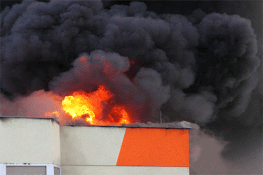
“The explosion that rocked a building at the Back River Wastewater Treatment Plant in March occurred because dust caught fire in a dryer used for sewage sludge, according to a report from the Baltimore City Fire Department,” The Baltimore Sun reported. “After the dryer turned on that morning, a spark ignited the dust, according to the report from the city’s captain of fire investigation. Then, thermal oil used in the dryer was ignited as well.”
CBS News reported that the explosion caused at least $10 million in damages.
Immediately following the explosion, the Maryland Department of the Environment had suggested it was caused by hot oil escaping from a leaking pipe. Nobody was injured in the explosion and this latest investigation has confirmed that it was accidental, but the incident has not helped the plant’s already tenuous reputation.
Following excessive sewage spills into nearby source water, operation of the Back River Wastewater Treatment Plant was taken over by state regulators, though problems persisted. And equipment issues following the explosion seem to have put the facility at risk of failing to meet environmental standards once again.
“After the incident, some key equipment at the building was forced offline, raising questions among environmental advocates whose eyes already were trained on the Back River plant due to its track record of maintenance issues and pollution,” according to the Sun. “But in April — the first full month of data after the explosion — the plant narrowly exceeded its allowable average concentration of phosphorus, a harmful nutrient that promotes the excess growth of algae in waterways.”
Following the release of the fire department investigation, state legislators have opted to continue their oversight of plant operations.
“Maryland regulators have extended supervision of the beleaguered Black River Wastewater Treatment plant through July after Baltimore City reported problems at the facility following an explosion in the spring,” per The Baltimore Banner. “…the state will continue to conduct frequent inspections of the Back River plant, and require the city to take steps to mitigate the effects of the March fire and operate the facility in compliance with its permit.”
As operators attempt to establish a consistent track record at this major Baltimore wastewater treatment facility, they are certainly hoping to avoid any more major setbacks.
To read more about how drinking water and wastewater treatment facilities respond to emergencies, visit Water Online’s Resiliency Solutions Center.
In an effort to improve public communication, the Louisiana Department of Health published its inaugural water system report cards last week, becoming the first state in the country to use annual letter grades to highlight the failures and successes of drinking water utilities.
Water systems are already required by federal law to send an annual Consumer Confidence Report to customers with details about drinking water contaminants. The Louisiana Department of Health grading system, which was mandated by a 2021 state law, goes several steps further, combining a range of measurements into a single letter grade for each of the state’s 951 community water systems.
On top of water quality, the grade incorporates data on utility finances, operations, and customer complaints. Utilities must include the grade on annual reports sent to customers.
Forty-one percent of water systems earned an A grade. Six percent received a D, and nine percent failed. Many of the failing systems serve small, rural communities, which often have fewer financial and technical resources.
Amanda Ames, chief engineer at the Department of Health, led the development of the grading system.
“It provides for accountability and for transparency,” Ames said. The public gets an easy-to-understand snapshot of their water provider, she said, while state agencies receive an overview of water utility conditions.
Though many states collect the same data that informs the Louisiana grades, a drinking water report card is a new step. But is it worthwhile to take it?
Manny Teodoro, who studies public policy and consults with water utilities, said that a report card makes intuitive sense. School systems use them. Health departments assign letter grades (or smiley faces) to restaurants based on their cleanliness. The American Society of Civil Engineers publishes an annual report card on the nation’s infrastructure. In the 2021 report card, drinking water systems received a C- and wastewater systems a D+.
All told, report cards have promise, Teodoro said. Still, details matter and he has reservations about how Louisiana designed its grading system.
The Louisiana system works mostly by subtraction, but also some addition. Water utilities start with a score of 100. Points are subtracted in seven categories of infraction that were spelled out in Act 98, the law that mandated the grades. Those categories include exceeding federal and state drinking water standards, failing to have evaluated their water rates, being the subject of customer complaints, and having deficient infrastructure. Utilities can earn up to 10 bonus points for having an asset management plan or participating in training programs.
Letter grades change every 10 points. Scores of 90 and above receive an A while scores below 60 earn an F.
Within the categories the Department of Health determined the point distribution. The highest point-value category is failure to meet federal drinking water standards. The maximum deduction for that category is 30 points, which Teodoro feels is too generous. A utility could have a slew of violations but its penalty is capped.
“This is a recipe for grade inflation,” said Teodoro, a professor at the University of Wisconsin at Madison who is helping to develop a water utility grading system in his state.
Teodoro also thinks that basing a grading system on deductions is more stick than carrot. In other words, even with the bonus points it does not encourage utilities to do more than the minimum requirement.
The Louisiana Department of Health, which developed the grading system itself, said that it looked at various designs, but “ultimately used a point deduction method because it was easy for the public to understand. These annual letter grades are a step in the right direction to increasing transparency and accountability and, ultimately, to increasing water system sustainability.”
Maureen Cunningham, director of water at the Environmental Policy Innovation Center, also called the grades “a step in the right direction” because they generate more information about utility performance. But she was not ready to endorse report cards, in general, as the best approach for improving drinking water outcomes.
“I worry that it’s not always a complete picture of what’s going on,” Cunningham said.
For instance, data on the number of customers who had their water shutoff is not a part of the Louisiana assessment. Nor is data on customer debt.
Cunningham also wondered how the report cards would be received. Could state agencies collect the necessary data and be transparent about the problems that certain communities face without condensing it all into a single letter grade? “I would be interested in seeing what motivates change better: giving someone a failing grade, or just pointing out, ‘Hey, this community needs X, Y, and Z to do a better job.’”
Though perhaps not a perfect system, the grades will be useful, said Leslie Durham, executive director of the Louisiana Infrastructure Technical Assistance Corporation, an agency set up to assist disadvantaged rural governments in applying for federal grants.
“I’m excited about it,” Durham said, referring to the report cards.
For years Durham has worked with rural water systems. In the past, she said it was difficult for some of these systems to acknowledge that they needed help. “They didn’t want to raise any flags or make any waves.” The grading system lays bare some of those struggles in an easy-to-digest format. Accessible information will lead to action, she said.
“Our organization plans on using that grading system to make sure we’re targeting the right folks,” Durham said.
Some are already getting help. Of the utilities earning a D or F, Ames said that more than 30 percent are in line to receive funding to upgrade their water systems.
For decades, humans have been pumping so much water out of the ground that it has caused Earth’s axis of rotation to shift, according to a new study published last week in the journal Geophysical Research Letters.
As the Earth spins, its rotational poles—where the imaginary line of the axis passes through the planet’s crust—naturally move a bit. Anything from ocean currents, to shifting molten rock in the mantle, to the melting of glaciers caused by climate change can lead to a shift in the distribution of mass across the globe and coax the axis to drift. Water stored in artificial reservoirs and seasonal changes in atmospheric winds can play a role as well, write the study authors. In the 20th century, Earth’s axis shifted about four inches per year, according to NASA.
But global warming isn’t the only human-caused factor moving the planet’s poles.The new study estimates that between 1993 and 2010, the pumping of groundwater and the resulting sea-level rise caused the poles to drift by about 2.6 feet.
“The very way the planet wobbles is impacted by our activities,” Surendra Adhikari, a geophysicist at NASA’s Jet Propulsion Laboratory who did not contribute to the research, tells Science’s Warren Cornwall. “It is, in a way, mind boggling.”
“Every mass moving around on the surface of the Earth can change the rotation axis,” Ki-Weon Seo, a co-author of the new study and a geophysicist at Seoul National University, tells Nature News’ Davide Castelvecchi.
The amount of shifting caused by removing groundwater doesn’t affect the length of a day or the seasons, as Clark Wilson, a co-author of the study and geoscientist at the University of Texas at Austin, tells New Scientist’s James Dinneen.
In the new study, the researchers used a computer model to look at the effects of different factors on the shift of the poles. When they didn’t include groundwater removal in their model, their predictions did not match the level of shift that scientists have observed. But when they took into account the massive amount of pumped water—which totaled more than two trillion tons between 1993 and 2010—their model fit the real-world observations.
From this analysis, the researchers estimate that the axis is moving 1.7 inches per year due to groundwater removal. Of the factors the study looked at, pumping groundwater was the second-largest contributor to the axis drifting, behind the melting Greenland ice sheet.
The paper calls attention to just how much water humans have pumped, as Manoochehr Shirzaei, a geophysicist at Virginia Tech who did not contribute to the study, tells New Scientist. “The precise number doesn’t matter really,” he tells the publication. “What matters is that the volume is so gigantic that it can impact the polar drift of the Earth.”
Groundwater removed from sites at the Earth’s midlatitudes, such as in the U.S. and India, has an outsize impact on polar drift, compared with extraction at the equator or the poles. However, most of the pumping has occurred in these high-impact zones, causing the water removal to have a bigger effect on the axis, Wilson tells Science.
Previous research has estimated that extracted groundwater, which eventually flows into the oceans, caused 6.24 millimeters of sea-level rise between 1993 and 2010. Between 2006 and 2015, global sea levels rose about 3.6 millimeters per year, and the new research confirmed that groundwater pumping has been a major contributor.
A bird walks at the Sierra Boyera Reservoir, which is at 0.01% of its capacity, in Belmez, southern Spain April 26, 2023
Residents of a small town in southern Spain gathered at the main square to collect drinking water as large swathes of the Iberian Peninsula braved unseasonally hot weather that have exacerbated a long drought.
Meteorologists expected temperatures to hit almost 40 Celsius (104 Fahrenheit) in some areas of Spain this week.
According to the Andalusia regional government, around 80,000 people living in Alcaracejos and another 27 villages in the province of Cordoba rely on truck deliveries for drinking water, since drought has exhausted the nearby reservoir and the water from another dam has been deemed unsafe for consumption.
“I have never experienced this before,” local resident Mari Carmen told Reuters after filling her bottles. She recalled times when they had running water for only a few hours a day, but never needing to carry the bottles home.
Although Spain’s reservoirs are on average at 50% of their capacity, levels have fallen to approximately 25% in Andalusia and the northeastern region of Catalonia.
The Guadalquivir Hydrographic Confederation certified earlier this month that water in the Sierra Boyera mountain range had been exhausted, the first time in 40 years that a reservoir in Cordoba has dried out.
“We are being supplied with water through a cistern. It’s a rather uncomfortable situation and, above all, precarious for the times in which we live,” Alcaracejos Mayor Jose Luis Cabrera said.
Residents can receive up to five litres (1.3 gallons) per day from a truck that drives through the affected villages.
In neighbouring Portugal, temperatures have also been abnormally high, with at least 36 C expected on Thursday in the district of Evora – in line with Portugal’s record for April set in 1945, or even beating that mark, weather agency IPMA said.
Authorities have declared three municipalities in Portugal’s southern region of Algarve at maximum risk of wildfires.
“We just got here today from the United States, we looked it up and it looked like it was going to be warm but I was not expecting it to be this hot,” tourist Brad DePolli told Reuters in Lisbon, where the temperature hit 32 C.
Authorities in France, meanwhile, will have wildfire-fighting troops and their water-carrying aircraft ready on June 1, one month earlier than usual, to adapt to fires starting earlier than in the past due to climate change.
This image shows an Almarai logo in Cairo, Egypt, on Wednesday, April 26, 2023. Fondomonte Arizona, a subsidiary of Almarai Co., has for nearly a decade grown alfalfa in the American Southwest that is sent to the Gulf kingdom to feed cows there. Arizona rescinded a pair of drilling permits that would have allowed Fondomonte to pump up to 3,000 gallons of water per minute to irrigate its forage crops.
In rural Arizona’s La Paz County, on the state’s rugged border with California, the decision by a Saudi-owned dairy company to grow alfalfa in the American Southwest for livestock in the Gulf kingdom first raised eyebrows nearly a decade ago. Now, worsening drought has focused new attention on the company and whether Arizona should be doing more to protect its groundwater resources.
Amid a broader investigation by the state attorney general, Arizona last week rescinded a pair of permits that would have allowed Fondomonte Arizona, a subsidiary of Almarai Co., to drill more than 1,000 feet (305 meters) into the water table to pump up to 3,000 gallons (11 kiloliters) of water per minute to irrigate its forage crops.
In an interview with The Associated Press, Attorney General Kris Mayes said she thought most Arizonans see it as “outrageous” that the state is allowing foreign-owned companies “to stick a straw in our ground and use our water for free to grow alfalfa and send it home to Saudi Arabia. We just can’t — in the midst of an epic drought — afford to do dumb things with water in the state of Arizona anymore.”
Mayes, a Democrat, sought the revocations after she said her office had found inconsistencies in the permit applications. Mayes vowed to look into Fondomonte’s operations and water use last year after the Arizona Republic reported that the Arizona State Land Department leased the company thousands of acres of farmland for below market value.
Fondomonte did not respond to multiple requests for comment from the AP. Its lawyers have said previously that the company legally leased and purchased land in the U.S. and spent millions on infrastructure improvements.
Years of drought have ratcheted up pressure on water users across the West, particularly in states like Arizona, which relies heavily on the dwindling Colorado River. The drought has also made groundwater — long used by farmers and rural residents with little restriction — even more important for users across the state.
Saudi Arabia, struggling with its own water shortages in the past decade, restricted the growth of some forage crops in the country. That Fondomonte chose Arizona as a place to grow such crops has angered some in the state, which has faced two consecutive years of federal water cuts from the Colorado River, a primary water source for the state.
Officials from both parties have criticized the use of state water by foreign-owned entities, with Gov. Katie Hobbs, also a Democrat, saying in her January state of the state address that she, too, would look into the practice. The state’s groundwater, Hobbs said, “should be used to support Arizonans, not foreign business interests.”
That same month, Republican state legislators introduced a bill to prohibit sales of state lands to foreign governments, state enterprises and any company based in China, Russia or Saudi Arabia.
“There’s a perception that water goes to local uses,” said Andrew Curley, a professor of geography and the environment at the University of Arizona. “When you recognize it’s going far away, that the products and benefits of this water are exported overseas, that really provokes people’s attention.”
Foreign entities and individuals control roughly 3% of U.S. farmland, according to the U.S. Department of Agriculture. Canada is the largest holder — mainly of forestland. Fourteen U.S. states have restrictions on foreign individuals or entities owning farmland, but limitations vary widely and no state completely prohibits it.
Fondomonte also farms in California’s Palo Verde Valley, an area that gets its water from the Colorado River. Those operations have attracted less scrutiny. And it’s not the only foreign company that farms in the Southwest. The United Arab Emirates-owned Al Dahra ACX Global Inc. grows forage crops in Arizona and California, and is a major North American exporter of hay.
U.S. farmers themselves export hay and other forage crops to the Middle East — mainly to Saudi Arabia. China is the primary export market for U.S. hay.
In Arizona, renewed attention to Fondomonte’s water use is raising questions about the state’s lack of regulation around pumping groundwater in rural parts of the state.
Phoenix, Tucson and other Arizona cities have restrictions on how much groundwater they can pump under a 1980 state law aimed at protecting the state’s aquifers. But in rural areas, little is required of water users besides registering wells with the state and using the water for activities, including farming that are deemed a “beneficial use.”
“Frankly, I believe they are not doing their jobs,” Mayes said about Arizona’s Department of Water Resources’ oversight of rural areas. The department declined to comment on the revoked drilling permits or the need for more groundwater regulation.
Mayes, along with hydrologists and environmental advocates, says more studies are needed of groundwater basins in rural areas — such as La Paz County, an agricultural county of about 16,000 people. Currently, Arizona doesn’t measure how much groundwater users pump in such areas, which means there is little understanding of how much water an operation like Fondomonte — or other farms — uses.
Almarai’s holdings in the Southwest are just one example of the farmland the company and its subsidiaries operate outside Saudi Arabia. It farms tens of thousands of acres in Argentina, which has also faced severe drought conditions in recent years.
Holly Irwin, a member of the La Paz County Board of Supervisors, has long opposed Fondomonte using water in the county. She said she’s fielded complaints from residents for years that it’s getting harder to pump water in nearby wells and has repeatedly asked the state to do something about it.
“We need to have some sort of regulation so it’s not all just being pumped out of the ground,” Irwin said.
By Pohang University of Science & Technology (POSTECH)
Open ocean water churning into waves
Water blankets around 70 percent of the Earth’s surface. Moreover, 97 percent of all the water on earth is seawater, which is impotable because of its salt content. But what if we could harness its potential as a new source of renewable energy?
Recently, a research team led by Professor Changshin Jo (Graduate Institute of Ferrous & Energy Materials Technology (GIFT), Department of Chemical Engineering) and Ph.D. candidate Hyebin Jeong (Chemical Engineering) at POSTECH has made strides in this area by confirming the superior performance of seawater batteries (SWBs) that incorporate chelating agents. Their findings were published in Chemical Engineering Journal.
Lithium-ion batteries have become ubiquitous in portable electronic devices and automotive batteries. However, they are not without limitations, as they present a risk of explosion and may become unusable if lithium supplies are depleted. To address these challenges, the development of next-generation batteries is currently underway. Among them, seawater batteries represent a promising option that utilizes Na-ions found in seawater to generate energy. These batteries offer the distinct advantage of easy resource accessibility and are environmentally friendly, as they require no separate treatment processes.
The high salinity of seawater can be attributed to the presence of Na-ions, which are utilized by seawater batteries to generate and store electrical energy as they move back and forth between the cathode and anode. However, one of the challenges in suing nickel hexacyanoferrate (NiHCF) as an intercalation cathode material for SWBs is the high occurrence of defects during fabrication. To address this issue, the research team synthesize NiHCF with a chelating agent (Sample A) and compared its performance with untreated NiHCF (Sample B) to evaluate the effectiveness of the chelating agent.
A look at the two samples under a microscope reveals the striking difference in their shape and structure. Sample B consists of randomly aggregated nanosized primary particles to form micro-level particles, whereas Sample A comprises individual 200-300 nanometer-sized cubic-shaped particles. Although the individual particle size of Sample B is smaller, it is less advantageous for battery production due to the aggregation of multiple particles into larger cohesive structures.
The researchers additionally assessed the electrochemical performance of both samples. Firstly, they measured the water content, and it was found that Sample A had lower water content than Sample B did. Generally, higher water content tends to impede electrochemical performance. Furthermore, measurements of current and voltage showed that Sample A had high energy efficiency and capacity.
The research team achieved a groundbreaking feat by performing 2,000 cycles of charging and discharging on batteries using two samples, where Sample A demonstrated a remarkable capacity retention rate of approximately 92.8%. Furthermore, the defect generation rate, a previous drawback of NiHCF, was observed to decrease to 6% in Sample A.
The results of the study demonstrate the superior performance achieved by adding a chelating agent to nickel hexacyanoferrate and using this as a cathode material in seawater batteries. This discovery can promote the development of seawater batteries as a promising candidate for next-generation energy storage systems.