Israel-Hamas war: Water is scarce in Gaza, and rockets force Blinken into a bunker

By: Bill Chappell, Aya Batrawy, and Jaclyn Diaz

JERUSALEM — Gaza’s 2.3 million residents are struggling to find clean, safe water — and some are drinking brackish water from wells, raising new health concerns in a Palestinian territory that’s under siege from Israel.

“Gaza is running dry,” UNRWA, the U.N. agency for Palestinian refugees, said on Monday, as conditions deteriorate ahead of an expected Israeli ground invasion.

Electricity is dangerously scarce: Israel shut off supply to Gaza’s main grid five days ago, and as hospitals cope with thousands of wounded people, fuel for generators is running low.

Israel began a bombardment of Gaza more than a week ago, after the Palestinian militant group Hamas killed at least 1,300 people in a surprise attack on Israel that also included hostage-taking. Since then, Israel has killed 2,778 people in the Gaza Strip, according to the Ministry of Health in Gaza.

Secretary of State Antony Blinken landed back in Israel on Monday after a visit last week, reiterating U.S. pledges of support for Israel — while also calling for aid and supplies to be allowed to enter Gaza. New rocket attacks briefly sent Blinken into a bunker.

Blinken, along with other U.S. officials, have been trying to work with Egypt to help usher in humanitarian aid into Gaza and to allow civilians, including Americans trapped there, to leave Gaza.

President Joe Biden held calls with German Chancellor Olaf Scholz, ahead of Scholz’s own planned travels to Egypt and Israel, and Egyptian President Abdel Fattah El-Sisi on Monday, the White House said.

The expanding humanitarian crisis in the Gaza Strip has pushed more international political bodies to discuss next steps.

European Council President Charles Michel called for an emergency meeting of the panel for Tuesday.

“It is of utmost importance that the European Council, in line with the Treaties and our values, sets our common position and establishes a clear unified course of action that reflects the complexity of the unfolding situation,” Michel said in a statement.

The Council plans to discuss providing humanitarian assistance as well as the long-term security and migration consequences of this conflict for Europe.

Here’s a rundown of where things stand right now:

Hospitals are running out of electricity

Hospitals in Gaza, which have been inundated with roughly 9,000 people wounded in Israeli attacks, only have enough fuel to keep their generators running through Monday night, the U.N. Office for the Coordination of Humanitarian Affairs said late Sunday.

Losing electricity would plunge the hospitals into a new crisis as life support and other systems are shut down — even as more of the injured and dead continue to be brought in.

“The shutdown of backup generators would place the lives of thousands of patients at risk,” OCHA said.

Doctors Without Borders says hospitals have also run out of painkillers. It says the wounded, many of them children, are left screaming in pain.

At least 1,000 Palestinians remain missing; many of that number are presumed dead, buried in rubble.

“The specter of death is hanging over Gaza,” said OCHA chief Martin Griffiths.

Emergency water and fuel are blocked from Gaza

At Gaza’s southern border, trucks loaded with fuel, water and other humanitarian supplies are waiting to cross over from Egypt through the Rafah crossing to bring some relief to the besieged area.

The border closed on Tuesday because of Israel’s airstrikes on the Gaza side. Israel says there’s no cease-fire deal in place to open the crossing; the U.S. says it’s working on it.

“Rafah will be open,” Blinken said on Sunday, as he visited Egypt on his way to Israel.

“We’re putting in place — with the United Nations, with Egypt, with Israel, with others — the mechanism by which to get the assistance in and to get it to the people who need it,” he said.

As of Monday night in Washington, D.C., the Rafah Crossing remained closed.

Even if the crossing does reopen, it’s an open question as to how the aid would be distributed. Roads leading to Rafah’s crossing have been destroyed, posing a serious challenge to any efforts to distribute fuel and water.

One reason the U.S. wants the border to open is so that some 500 to 600 Americans, including those of Palestinian origin, and other foreign nationals, can leave Gaza. But Egypt says that if the border crossing opens for people to exit, it must also remain open to allow aid to reach Gazans from Egypt’s side.

On Monday, Blinken met with Israeli President Isaac Herzog to reiterate U.S. support for Israel’s right to defend itself from Hamas’ terrorism. He reaffirmed U.S. commitment to provide Israel with the assistance it needs to protect its citizens.

The U.S has already sent a warship to the eastern Mediterranean — a measure it says is aimed at deterrence. It has also sent to Israel “small diameter bombs” and is sending more ammunition and interceptor missiles for Israel’s Iron Dome, which intercepts most Hamas rockets that are fired at Israel.

As part of that promised U.S. support, some 2,400 Marines with the 26th Marine Expeditionary Unit now off Kuwait were ordered late Monday to head west into the Red Sea with a possible direction to head into the Eastern Mediterranean, an official told NPR. The Marines could take part in any civilian or embassy evacuation, the official said.

Another 2,000 American troops will be sent on a short deployment, expected to last between 24-48 hours, to the Middle East. Those soldiers will consist of medical troops, explosive ordinance and potentially military police, according to an official that spoke to NPR.

None of these troops are expected to get involved in any combat missions related to the Israel-Hamas fight.

People are trying to flee northern Gaza

Israel has repeatedly told more than 1 million Palestinians to leave their homes in northern Gaza and head south, setting a mass evacuation in motion that lacks essential supports and has no clearly defined destination.

Israel says it will not stop its attacks until it has completely destroyed Hamas. “Every Hamas member is a dead man,” Prime Minister Benjamin Netanyahu said last week.

The Israeli military dropped leaflets from the sky, telling people in northern Gaza to leave their homes. Many of the hundreds of thousands who did so traveled by foot, walking for miles. Mothers were seen carrying their babies as they headed south, with no guarantee of safety at the other end of their trek.

Those left behind included people wounded in Israel’s bombardment, as well as those who are disabled or elderly, or were simply unable to find transportation to take them out of the north.

The Israeli military says Hamas is “responsible for the humanitarian consequences” of the violence and chaos that followed last weekend’s attack and the ensuing evacuation order.

Rockets target Israeli cities

Sirens sounded in Tel Aviv and Jerusalem on Monday, warning of new rounds of rocket attacks. The alarms briefly sent lawmakers and others into shelters at the Knesset, where parliament was beginning its winter session.

Rockets also forced Blinken to move to a bunker for about five minutes.

In Israel, families are holding funerals and grieving — and some are also waiting for DNA confirmation of whether their loved ones are among the bodies found in southern Israel in communities known as kibbutzim that were overrun by the militants. The dead include 30 U.S. citizens.

Other families are waiting to hear whether their missing loved ones were taken hostage. Israel’s military said on Monday that 199 hostages are being held in Gaza — far higher than previous estimates.

Militants in the Gaza Strip say some 22 hostages, among them foreigners, have been killed in Israeli airstrikes.

In northern Israel, people who live within about a mile of the border with Lebanon are now under evacuation orders. The Israel Defense Forces say the residents will be moved into “state-funded guesthouses.”

The evacuation order covers 28 communities, according to the IDF.

Americans who want to leave Israel are doing so on planes and boats, in a slow and uncertain process. The State Department says flights are leaving from Ben Gurion International Airport on Monday and Tuesday.

And on Sunday, U.S. nationals and their immediate relatives were told to report to the seaport in Haifa for a chance to board a U.S.-organized evacuation ship leaving Israel, bound for Crete. Crowds of people showed up, and officials reportedly told some to come back another time.

Aid agencies portray dire circumstances in Gaza

“People are going through the most difficult times of their history in Gaza,” Hisham Mhanna, a spokesperson for the International Committee of the Red Cross, told NPR from southern Gaza.

Mhanna said there are thousands of people who have been left without any shelter, not even a blanket or mattress. Physicians have been working at their limits since the violence escalated, he said.

“Some of the doctors actually received casualties, which turned out to be members of their own families, dead and injured,” he said. “Despite all that, they continue to serve and they continue to save people’s lives.”

A quarter of a million people have moved to shelters in Gaza over the past 24 hours, according to the UNRWA, which says most of those people are seeking refuge in schools where “clean water has actually run out.”

Most of its shelters in Gaza have run out of clean water, and others are on daily rations, the UNRWA said. Shops have run out of bottled water, and people’s water tanks have emptied. Some families in Gaza are now drinking contaminated water.

The U.N. agency says 14 of its staff members are confirmed to have been killed, adding that the actual number is likely higher.

CLICK HERE TO LEARN MORE: https://www.npr.org/2023/10/16/1206100831/israel-hamas-war-gaza-water-blinken-palestine

Amazon’s Indigenous People Urge Brazil to Declare Climate Emergency as Rivers Dry Up

By Bruno Kelly

MANAUS (Reuters) – Indigenous inhabitants in the Amazon are asking the Brazilian government to declare a climate emergency as their villages have no drinking water, food or medicine due to a severe drought that is drying up rivers vital for travel in the rainforest, their leaders said on Tuesday.

The drought and heatwave has killed masses of fish in the rivers that Indigenous people live off and the water in the muddy streams and tributaries of the Amazon river has become undrinkable, the umbrella organization APIAM that represents 63 tribes in the Amazon said.

“We ask the government to declare a climate emergency to urgently address the vulnerability Indigenous peoples are exposed to,” APIAM urged in a statement released at a news conference.

The Rio Negro, Solimoes, Madeira, Jurua and Purus rivers are drying up at a record pace, and forest fires are destroying the rainforest in new areas in the lower Amazon reaches, APIAM said in a statement.

Environment Minister Marina Silva told Reuters last month the government was preparing a task force to provide emergency assistance to the Amazon region hit by the drought. It has sent tens of thousands of food parcels to communities isolated by the lack of river transport.

The region is under pressure from the El Nino weather phenomenon, with the volume of rainfall in the northern Amazon below the historical average.

The most serious problem for Indigenous communities that have no running water is sanitation now that the river water cannot be drunk, APIAM coordinator Mariazinha Bare said.

“The smaller rivers have dried up and turned to mud,” Bare said in an interview. “Indigenous people have to walk long distances in the rainforest to find potable water, and the poor quality of water is making people ill,” she said.

Impassable rivers have made it harder for medical assistance to reach Amazon villages, Bare said, and rain is not expected until the end of November or early December when the rivers and their fish population normally renew themselves.

The Madeira river to the southwest is no longer navigable in its upper reaches, isolating Indigenous villages and non-Indigenous communities that rely on collecting fruit in the rainforest but cannot move their produce out.

Ivaneide Bandeira, who heads the Kaninde Indigenous organization in the state of Rondonia, said isolated non-Indigenous communities were asking Indigenous villages for food.

She said the smoke from forest fires was worse than ever, aggravating the climate crisis and affecting the health of the elderly and children.

“It is not just the El Nino current. Deforestation continues with these fires,” she said by telephone. “The agricultural advance does not stop. They are destroying everything, as if they do not see what is happening to nature,” she said.

CLICK HERE TO LEARN MORE: https://www.usnews.com/news/world/articles/2023-10-10/amazons-indigenous-people-urge-brazil-to-declare-climate-emergency-as-rivers-dry-up

Concerns growing over chemicals found in South Florida water

By Hatzel Vela

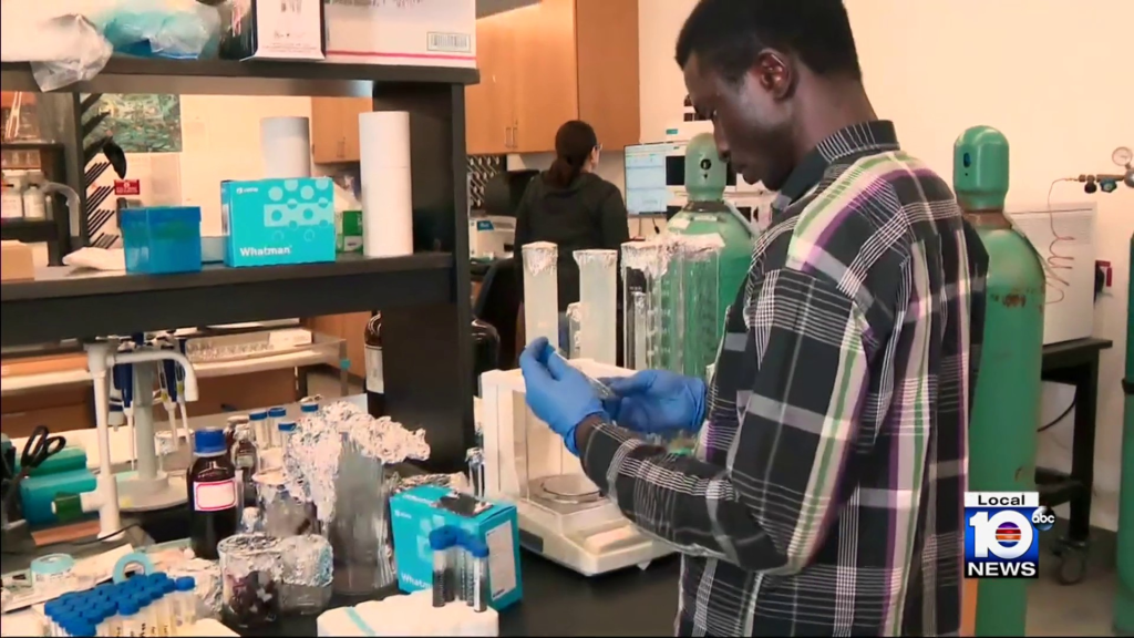
NORTH MIAMI, Fla. – Inside a Florida International University lab, work is being done to learn more about PFAS, which are often called forever chemicals.

Natalia Soares Quinete is an assistant professor at FIU’s Department of Chemistry and Biochemistry and with the Institute of Environment.

“I’m not going to lie to you…it is a big issue,” she said. “You find it in water, we find it in soil, we find it in bio solids, in rain water.”

Quinete heads the department that has been closely studying the man-made chemicals and the risk they pose to our health.

Their studies include taking samples in South Florida, from Miami-Dade, Broward and Palm Beach counties.

“We collected tap waters,” she said. “We found out that those compounds are everywhere.”

Quinete said the numbers are typically more concentrated in areas like airports and military bases.

“The concentration varies,” she said.

A couple weeks ago, the issue of these chemicals in our drinking water came up before Broward County commissioners.

In Broward, cities will soon need to take action to reduce the amount of these toxic chemicals in the water.

As Quinete notes, it’s not only a problem with the water though.

“Try to avoid cooking with Teflon pans,” she said. “Try not to use those water resistant makeups, because they also have PFAS.”

With water at home, filters can help but they are not a 100% effective solution.

CLICK HERE TO LEARN MORE: https://www.local10.com/news/local/2023/10/06/concerns-growing-over-chemicals-found-in-south-florida-water/

Proposed Martin County development promises clean water, sustainability but draws mixed reactions

By: Kate Hussey

MARTIN COUNTY, Fla. — Martin County could be getting a new development, one that many people may have heard about by now.

“Storie FL” has been advertising itself for about a year now as a new kind of living focused on sustainability and clean water.

If approved, it would be built on the 2,700 acres of land centered at the intersection of Southwest Pratt Whitney and Bridge roads.

According to the site plan, 40% of the development would include about 4,000 mixed-use homes, a fire station, charter school, dog park, public pool and other amenities.

The other 60% of the plan would remain preservation areas and include 25 miles of walking and biking trails along with a European-style canal system that would run throughout the complex.

According to Storie FL’steam, it would also include a water filtration system to ideally treat 500 million gallons of water from the C-44 canal to address Martin County’s water quality issues.

“They’ve really, really taken the time, over a year, to put together this site plan that meets with what Martin County and the Commission is trying to do, which is to develop in an environmentally sustainable fashion,” Laurie Andrews, the president of Cotton & Company, said.

Andrews is representing the developer of the project, Buzz Divosta.

It’s not the first time Divosta tried to develop that plot of land, which he purchased about 10 years ago.

Several years after the purchase, Divosta submitted a site plan to the county, which was rejected by commissioners. This time around, Andrews said he worked hard to design a development that addressed the concerns of commissioners and their constituents.

“We love our natural environment,” Andrews said. “We love what makes Martin County unique. Nobody’s trying to destroy that. At the same time, we all need a house to live in.”

Yet several residents in Martin County told WPTV they still had concerns.

Lifetime resident Allison Sweeney-Solis said she feels like Martin County is starting to become a bit of a concrete jungle.

“When I was a kid, everything was two lanes and dirt roads. Now everything is concrete,” Sweeney-Solis said. “It is starting to get over-developed.”

Carl Frost, the owner of Kai-Kai Farms, saw both benefits and negatives to the project. On the one hand, his farm survives on agri-tourism and told WPTV he felt the development would help grow his business.

“This is a real popular wedding ceremony location. Without the hospitality income, a small farm like this couldn’t survive,” Frost said. “The more people that move in the area, that’s a good thing right? We get more weddings, more dinners.”

Yet while Frost saw short-term benefits, he also felt that in the long run, the development could hurt his business. For one, he fears a development with more people next door to his farm would lead to complaints about his machinery and eventually shut him down.

“More and more neighbors around, they complain, ‘Oh, it’s too noisy, there’s too much traffic,'” Frost said.

Second, he fears the project would create a scarcity of water.

“One of the pressures of urbanization would definitely be water scarcity, as there’s more houses built, more consumption of fresh water, that can affect the farm,” Frost said.

Andrews addressed both of those concerns. She said since all of the wetlands are being preserved, the development shouldn’t negatively affect the water in the surrounding area. If anything, she said it should improve it.

“Our areas are going to be revitalized, not going to be destroyed,” Andrews said. “Anything there that’s wetlands and trees, it’s going to stay.”

Addressing the second concern, Andrews said she feels with the number of preservation areas and hiking trails, there will be plenty of sound buffer between the farmers and surrounding residents and said the project shouldn’t push out the agriculture in the area.

Still, residents like Sweeney-Solis and Frost said only time will tell if those promises are kept.

In the meantime, Frost said he’ll leave the development battle to others; instead, he’ll fight his own battle at home.

“My battle is right here,” Frost said. “Bugs, every leaf that’s chewed is a battle.”

The project is by no means approved yet.

Storie FL submitted an updated application to Martin County on Sept. 7. The county has about a year from then to either approve or deny it.

CLICK HERE TO LEARN MORE: https://www.wptv.com/money/real-estate-news/proposed-martin-county-development-promises-clean-water-sustainability-but-draws-mixed-reactions

Sarasota Bay’s water quality is the best it’s been in 8 years. Can we keep it that way?

By: Carter Weinhofer

Sarasota Bay’s water quality is the best it’s been in eight years. 

That’s what Executive Director of the Sarasota Bay Estuary Program Dave Tomasko said in his most recent director’s note. 

But while it may be a good time to reflect on the positives, it’s not time to take a break.

We can’t let the water quality slip away again, Tomasko said.

He explained that in a recent meeting with colleagues at the Florida Department of Environmental Protection, he was told that FDEP would be releasing their “Draft Impaired Waters List” and “Draft De-List List.” 

The lists summarize bodies of water that are considered out of compliance with water quality standards, and conversely those that are improving so much that they can be taken off the list. 

From the conversation, he learned that Sarasota Bay, Roberts Bay, Little Sarasota Bay and Blackburn Bay will all be delisted for nutrient pollution. 

Simply put, the algae in Sarasota Bay has decreased so much that the water meets the standards to be considered “good quality.” 

“If you go out in the bay, you can tell the difference compared to where we were a few years ago,” Tomasko said.

Science talk

The main nutrient in question is chlorophyll-a. 

A higher amount of chlorophyll-a in the water is an indicator of more algae in the water. Chlorophyll is the molecule found in all plants that allows the organisms to absorb sunlight and photosynthesis. 

Nutrients like nitrogen and phosphorus feed the algae. 

If you want your lawn to be greener, you add nitrogen and phosphorus, Tomasko said. Likewise, if you wanted the bay to be more green than blue — meaning more algae than clear water — you would add more nitrogen and phosphorus. 

The first part of that analogy is part of the problem: fertilizers containing nitrogen and phosphorus are common culprits of runoff issues. 

More algae is like putting a blanket on your front lawn, Tomasko said in another analogy. The blanket suffocates the vegetation by preventing sunlight from reaching what lies below it. 

Which is precisely what algae overgrowth does to seagrasses.

Seagrasses are important bases for ecosystems, providing food sources for fish, crabs, manatees and sea turtles. 

Two of the most common seagrasses found around Florida, turtle grass and manatee grass, are named after the animals that consume the species as a main food source. 

Tomasko said he’s already seeing these important seafloor forests recovering. 

Between 2014 and 2018, Tomasko said the lower part of Sarasota Bay lost about 30% of its seagrass coverage. This was mostly related to a couple of very wet years, and problems with overwhelmed wastewater treatment facilities.

The biggest decline in recent years, according to Tomasko, occurred between 2018 and 2020 in the upper part of the bay, just southeast of Sister Keys. About 2,000 acres were lost. 

This is believed to be associated with the red tide event that began in 2017, and had major impacts on the bay’s water quality. 

Tomasko and colleagues with SBEP have been tracking that area for the last couple years, and have been seeing the potential for recovery. 

Around mid-September, Tomasko said the amount of seagrass was impressive. They found an abundance all over the place. 

Although aerial data of seagrass coverage won’t be taken for another year, Tomasko is hopeful. 

“We think it’s going to be a huge increase, maybe multiple hundreds of acres,” he said. “It was one of my best days out in the field.” 

Aaron Zimmerman works with water quality for Sarasota County, where he’s been a part of the research since 2021. 

Overall, he agrees with Tomasko’s observations. He’s also seen good trends for seagrass and a decreased abundance of macroalgae. 

Zimmerman said what’s important about their research is that while aerial images take good readings of overall seagrass coverage, the work he does with his team is able to provide a more detailed look. 

This includes seagrass coverage by species, the three most common ones being shoal, manatee and turtle grass. 

Zimmerman said he can say firsthand from being on the water that it seemed clearer in terms of quality, most likely meaning chlorophyll levels are going down. This means algae production is also decreasing. 

So all in all, reducing the amount of nutrients getting into the water will decrease the amount of algae in the water, which in turn will help water quality and allow seagrasses to recover. 

Big-ticket fixes, big payoff

Tomasko and scientists with Sarasota County agree that the most impactful reasons behind this good news are the improvements on the larger scale: upgraded stormwater and wastewater infrastructure. 

A few examples Tomasko pointed out in his director’s note include the Bee Ridge Wastewater Treatment Plant upgrades of over $250 million, the county’s wastewater treatment plant improvements, the Celery Fields project and ongoing stormwater retrofit projects at the Bobby Jones Golf Course. 

Heather Bryen has been with the county stormwater and water quality team since 2011, and has seen a lot of improvement projects big and small.

“They’re very committed to putting their money where their mouth is and getting the job done,” Bryen said. 

Tomasko said the hundreds of millions of dollars that local governments are spending on wastewater and stormwater improvements are paying off by reducing the inflow of nutrients. 

Can’t stop, won’t stop

Though good news is worth celebrating, Tomasko urged it’s not time to say it’s good enough — this area has already made that mistake once before. 

This time, Tomasko hopes bay residents have learned lessons from the past. 

“It’s the re-restoration,” Tomasko said. “We already did it once and then we let it slip away, and now we’re trying to get it back again.”

In the mid-90s, Tomasko said a similar increase in water quality occurred. But, locals let that slip away due to the pressure of massive population growth, aging infrastructure, wetter weather and warming waters. 

Now local officials are ensuring that everyone can do their part. 

Mollie Holland is the coordinator of a county program called NEST, which stands for Neighborhood Environmental Stewardship Team. 

In her words, NEST takes the large-scale problems and boils them down to the community level to show residents what they can do to be a part of the solution. 

She’s even helped write a book, “Healthy Ponds Guide,” that is a comprehensive guide to being a water-conscious citizen. 

Some things are easier to implement. 

One of the most important ways people can help is to not be a part of the problem: by not overfertilizing lawns, not blowing grass clippings into the bay or drainage and to pick up after dogs. 

By taking those suggestions into consideration, people can help prevent nutrients like nitrogen and phosphorus from entering the water system.

And some of these solutions are actually money savers, Holland said. Using less fertilizer is less expensive. 

But when certain projects come with increased costs, Holland said it’s also her group’s job to educate people about the importance of these improvements. 

“Sometimes you have to break a few eggs to make an omelet, and spend some money and invest in our future and our climate here,” Holland said.

Most residents want to be a part of the solution, she said, because the water and the environment are one of the state’s biggest draws. 

“When you ask folks why they come here, yes, it’s the sunshine and the warm weather,” Holland said. “But nine chances out of 10 when you ask somebody why they’re here it’s because of the environment.”

Tomasko’s recent meeting with FDEP colleagues served another purpose — to set even higher standards for the bay’s water quality. 

Sarasota Bay Estuary Program will be pursuing a reasonable assurance plan for Sarasota Bay, in collaboration with local governments, FDEP and the EPA. 

The reasonable assurance plan, Tomasko said, will propose stricter water quality standards. 

Higher standards aren’t meant to set the bay up for failure though, he said. It’s to ensure that the millions of dollars going into stormwater and wastewater projects aren’t put to waste — and to make sure the water quality doesn’t decline again. 

CLICK HERE TO LEARN MORE: https://www.yourobserver.com/news/2023/oct/11/sarasota-bays-water-quality-best-in-years/

Why the saltwater wedge climbing up the Mississippi River is a wake-up call to the region

By: Roby Chavez

NEW ORLEANS — A saltwater intrusion from the Gulf of Mexico predicted to reach metro New Orleans by the middle of this month has slowed, a relief to emergency officials and communities who were bracing for the worst.

The massive saltwater wedge moving up the Mississippi River, the area’s main source of drinking water, threatened to expose close to a million residents in four parishes to dangerous levels of salt water. Now, the saltwater wedge has slowed considerably. As of last week, it hasn’t moved for 10 days and remains at a standstill 20 miles south of the city.

New predictions announced by the U.S Army Corps of Engineers last week suggest it likely won’t reach far enough upriver to threaten the drinking supply for most of Orleans and Jefferson Parishes.“This updated projection is clearly a relief to all of us,” said Collin Arnold, director of the New Orleans Office of Homeland Security and Emergency Preparedness. “But our job in emergency management is to help prepare for the worst. I think we all believe that we will face this again at some point.”

Historic low river levels for the second year in a row have left the Mississippi River susceptible to water flowing up from the Gulf of Mexico.

For the last few weeks, emergency officials were desperately searching for other sources of fresh water, anticipating unsafe drinking water. Despite the new improved predictions, officials are still moving ahead with precautions for areas that have already been affected. The latest close call has raised questions and deepened concerns about the mighty Mississippi River, which is steadily drying up and slowing down. Corps officials stressed river levels will likely remain low through January, and they noted that forecasts could again change.

Similar saltwater intrusions have happened about once every decade, including in 1988, 1999, 2012, and 2022. Louisiana has in the past averted major problems from high levels of salt water, like damaging pipes and water intake systems, as well as being a danger to people on low-sodium diets. But this is the second such event in as many years. Leaders say it’s taking longer for the region to recover from back-to-back years of low river flow, which points to the urgency for long-term solutions.

While it seems a worst-case scenario won’t play out this time, smaller communities like Plaquemines and St. Bernard Parishes are already inundated with salt. Plaquemines Parish has relied on bottled water for bathing, cooking, and drinking since June. The Corps will have to continue to barge more than eight million gallons of fresh water a day to flush out its water systems.

What is happening with the Mississippi River right now?

Water levels have drastically dropped due to extreme heat and drought intensified by climate change, slowing the river’s powerful current. The U.S. Drought Monitor map in September showed that a majority of the Mississippi River Basin, which stretches 2,350 miles, is experiencing extreme or exceptional drought conditions.

How much water flows through the river and how quickly is key to prevent salt water from intrusion. The Corps said the river was flowing at 150,000 cubic feet per second, half of what is needed to keep salt water out.

Rain can help. But that “would require about 10 inches across the entire Mississippi Valley for us to get flows above 300,000 cubic feet per minute,” Col. Cullen Jones, commander of the Corps’ New Orleans office, told the New Orleans City Council in late September.

The major change in the timeline is partially due to more water than expected flowing down the river. But it’s been a wake-up call for the region to upgrade water plants, expand pipeline networks, and make other improvements.

Jones said strategic mitigation work to heighten an existing underwater levee or sill, among other precautions, has diminished the emergency. The improved outlook also comes following new flow forecasts that predict a slowdown of the wedge’s intrusion upriver.

Salt water is heavier than fresh water, so it sits on the bottom of the river. The augmented sill, which Jones said is now 62 percent complete, works as an underwater levee until the amount of salt water reaches high enough to breach the sill.

“We are ahead of schedule,” Jones said. “Our daily surveys show the salt water that overtops the sill has less density and salinity than that behind the wedge.”

The new track now predicts the saltwater intrusion will only reach smaller water intakes in the community of Algiers, located just across the Mississippi River from the historic French Quarter district, and not until Nov. 23, a month later than originally expected.

Other help came from the Mississippi River’s depth at the salt water’s current location. Salt water had already advanced nearly 70 miles up the river. During the past month, the saltwater wedge traveled 15 miles upriver in one week but came to a standstill last week. Jones said it was due to it settling in a 120-foot-deep hole in the river.

“It’s been filling in a very deep pocket in the river, giving us more time, a lot more … When you look at what has changed, it is because we beat the original forecast,” Jones said. “As we increased the height of the sill, we’re getting an additional speed bump.

How did the outlook change?

Emergency management officials have been collaborating for weeks and were moving with deliberate speed on various plans to dilute the salt in water systems, including building expensive pipelines, barging in fresh water from further upriver, installing desalination equipment, and augmenting the underwater dam in the Mississippi River to slow the progress of the saltwater intrusion.

After meeting with state and local emergency management officials and Corps representatives, Gov. John Bel Edwards sounded the warning on Sept. 22. He called the situation serious but urged people not to panic.

“We will get through this just as we have with other emergencies and that is by working together,” Edwards said.

Edwards stressed that the emergency requires a well-planned engineering response, multiple mitigation efforts, and regional cooperation.

“This is a very challenging situation. There is not one thing that is going to solve this challenge for us. It will be a combination of lots of different efforts,” Edwards said as planning got underway.

President Joe Biden declared a federal emergency in Louisiana on Sept. 22, which quickly brought federal disaster assistance and helped ramp up mitigation efforts.


The Corps vowed to transport via barge as much as 36 million gallons of fresh river water daily into the region to dilute the saltiness to safe levels. In recent days, barges began rushing in 15 million gallons of fresh water collected from further upstream to mix with the intake at affected riverside water treatment plants to dilute salt water.

Rural areas also started to use salt-filtering equipment to supplement the barge water. Plaquemines Parish acquired three desalination units to filter salt water for all five of its water treatment plants and are already cleaning water for the Parish’s 22,800 residents.

Orleans and Jefferson Parishes, with a combined population of more than 800,000 people, put their hopes in constructing pipelines because barge water would not be sufficient. For example, New Orleans Mayor LaToya Cantrell said the city’s Carrollton water treatment facility uses 141 million gallons each day. Now, the prediction is that the plant may not experience saltwater intrusion.

To buy some time, the Corps started dredging the Mississippi to increase the height of the underwater sill by 25 feet. It was expected to slow the saltwater by 10 to 15 days. In reality, it created a month’s delay.

In populous Jefferson Parish, which borders New Orleans, workers rushed to start construction of a 14-mile flexible pipeline. The multimillion-dollar project is designed to transport fresh water from further upriver where the salt level is expected to remain much lower.

Despite the changing timeline, that work will continue. “Due to the nature of this changing environment and that we’re going to get new forecasts every week, we certainly don’t want to lose any time or get flat-footed if something were to change on us,” Jefferson Parish President Cynthia Lee Sheng said. “We want to see if this works.”

By Oct. 4, work on their pipeline in Jefferson Parish was well underway but work had not started in New Orleans. Mayor Cantrell said she was confident enough of the pipeline could be built in time to maintain safe drinking water during the saltwater emergency. Now, it won’t be necessary and the hugely expensive pipeline could be avoided if predictions hold.

Instead, Orleans Parish is shifting its focus to ensure fresh water at the smaller river intake in Algiers, a New Orleans neighborhood that sits across the river from the city’s French Quarter, where saltwater intrusion is expected on Nov. 23.

The pipeline plan came with a hefty $250 million price tag and the Sewerage & Water Board of New Orleans is glad to have more time to rebid the plans and not be rushed.

“We intend to stand the course until the situation is completely resolved,” said Ron Spooner, the board’s interim general superintendent. “Today is truly the answer to all of our collective prayers. This gives us time for more planning what we need to do.”

Spooner said it’s possible that the sewerage and water board will postpone parts of the plan to explore more permanent solutions.

“This is a regional effort — state, local, and federal level — because the more we look into it, the magnitude of the solutions is quite expensive,” Spooner said as planning started several weeks ago.

What are the health issues caused by saltwater intrusion?

When salt levels go above 250 parts per million, as they already have reached in Plaquemines Parish, they pose a risk to individuals on low-sodium diets; those with cardiovascular disease, high blood pressure, or kidney disease; as well as dialysis patients, infants, and pregnant people, according to the Louisiana Department of Health.

“For the vast majority of people, you will stop drinking the water because it doesn’t taste well before it becomes a danger to your health,” Louisiana state health officer Dr. Joseph Kanter said.

Health officials also note salt water is not appropriate for pets to drink.

Over time, high levels of salt water can cause damage to plumbing, appliances, cooling systems that use water, and water heaters in homes and buildings. Emergency management officials say sodium cannot be easily removed from drinking water through boiling or conventional filtration like Brita filters.

Salt water can accelerate the corrosion of pipes in water distribution systems. Health officials say saltwater intrusion could corrode lead and galvanized steel pipes, possibly leaching heavy metals into drinking water, depending on how long the emergency lasts.

“This is similar to what happened in Flint, Michigan – incoming water was not treated properly and led to corrosion of lead pipes throughout the system,” according to a statement from the New Orleans Office of Homeland Security and Emergency Preparedness. “This contaminated Flint’s water system with heavy metals such as lead and copper, which left water undrinkable and required a major effort to replace corroded pipes.”

Sewerage and water board officials acknowledged that salt water could increase lead contamination but said it’s too early to predict the severity. Kanter said very frequent testing will be required.

“Any speculation about impacts is premature, but we are working diligently with top experts at Louisiana Dept. of Health and the Environmental Protection Agency to prepare to increase our frequency of lead testing and address impacts swiftly with a full range of resources,” a sewerage and water board spokesperson said in an email to the Times-Picayune.

While the clock has slowed and it appears that the major population centers’ water intake systems may be spared, emergency officials say the goal remains the same even if they are breathing a bit easier as they drink a cold glass of water — sans the salt.

“To maintain as close as possible the normal operations of our water treatment facilities and drinking water capabilities across the impacted area,” said Casey Tingle from the Governor’s Office of Homeland Security and Emergency Preparedness.

CLICK HERE TO LEARN MORE: https://www.pbs.org/newshour/nation/why-salt-water-is-threatening-drinking-water-in-new-orleans-and-what-officials-are-doing-about-it

Ancient carbon in rocks releases as much carbon dioxide as the world’s volcanoes

By: The University of Oxford

A new study led by the University of Oxford has overturned the view that natural rock weathering acts as a CO2 sink, indicating instead that this can also act as a large CO2 source, rivalling that of volcanoes. The results, published today in the journal Nature, have important implications for modelling climate change scenarios.

Rocks contain an enormous store of carbon in the ancient remains of plants and animals that lived millions of years ago. This means that the “geological carbon cycle” acts as a thermostat that helps to regulate the Earth’s temperature. For instance, during chemical weathering rocks can suck up CO2 when certain minerals are attacked by the weak acid found in rainwater. This process helps to counteract the continuous CO2 released by volcanoes around the world, and forms part of Earth’s natural carbon cycle that has helped keep the surface habitable to life for a billion years or more.

However, for the first time this new study measured an additional natural process of CO2 release from rocks to the atmosphere, finding that it is as significant as the CO2 released from volcanoes around the world. Currently, this process is not included in most models of the natural carbon cycle.

The process occurs when rocks that formed on ancient seafloors (where plants and animals were buried in sediments) are pushed back up to Earth’s surface, for example when mountains like the Himalayas or Andes form. This exposes the organic carbon in the rocks to oxygen in the air and water, which can react and release CO2. This means that weathering rocks could be a source of CO2, rather than the commonly assumed sink.

Up to now, measuring the release of this CO2 from weathering organic carbon in rocks has proved difficult. In the new study, the researchers used a tracer element (rhenium) which is released into water when rock organic carbon reacts with oxygen. Sampling river water to measure rhenium levels makes it possible to quantify CO2 release. However, sampling all river water in the world to get a global estimate would be a significant challenge.

To upscale over Earth’s surface, the researchers did two things. First, they worked out how much organic carbon is present in rocks near the surface. Second, they worked out where these were being exposed most rapidly, by erosion in steep, mountain locations.

Dr Jesse Zondervan, the researcher who led the study at the Department of Earth Sciences, University of Oxford, said: “The challenge was then how to combine these global maps with the river data, while considering uncertainties. We fed all of our data into a supercomputer at Oxford, simulating the complex interplay of physical, chemical, and hydrological processes. By piecing together this vast planetary jigsaw, we could finally estimate the total carbon dioxide emitted as these rocks weather and exhale their ancient carbon into the air.”

This could then be compared to how much CO2 could be drawn down by natural rock weathering of silicate minerals. The results identified many large areas where weathering was a CO2 source, challenging the current view about how weathering impacts the carbon cycle. Hotspots of CO2 release were concentrated in mountain ranges with high uplift rates that cause sedimentary rocks to be exposed, such as the eastern Himalayas, the Rocky Mountains, and the Andes. The global CO2 release from rock organic carbon weathering was found to be 68 megatons of carbon per year.

Professor Robert Hilton (Department of Earth Sciences, University of Oxford), who leads the ROC-CO2 research project that funded the study, said: “This is about 100 times less than present day human CO2 emissions by burning fossil fuels, but it is similar to how much CO2 is released by volcanoes around the world, meaning it is a key player in Earth’s natural carbon cycle.”

These fluxes could have changed during Earth’s past. For instance, during periods of mountain building that bring up many rocks containing organic matter, the CO2 release may have been higher, influencing global climate in the past.

Ongoing and future work is looking into how changes in erosion due to human activities, alongside the increased warming of rocks due to anthropogenic climate changes, could increase this natural carbon leak. A question the team are now asking is if this natural CO2 release will increase over the coming century. “Currently we don’t know — our methods allow us to provide a robust global estimate, but not yet assess how it could change” says Hilton.

“While the carbon dioxide release from rock weathering is small compared to present-day human emissions, the improved understanding of these natural fluxes will help us better predict our carbon budget” concluded Dr. Zondervan.

CLICK HERE TO LEARN MORE: https://www.sciencedaily.com/releases/2023/10/231004132437.htm

Extreme fires and heavy rainfall driving platypuses from their homes

By: The University of Melbourne

Australia’s emerging pattern of severe mega bushfires and heavy rainfall may be driving platypuses from their homes, a new study by University of Melbourne researchers has shown. 

Analysis of platypus DNA in rivers and creek water samples collected before and after the Black Summer 2019-2020 megafires suggest Australia’s beloved semi-aquatic monotremes might be abandoning severely bushfire-affected areas for up to 18 months after a fire, especially if heavy rainfall has followed the fire. 

The study uses the recent technique of environmental DNA sampling, where animal DNA is collected from water, soil, air, or snow rather than directly from the animal itself. This helps scientists indirectly record hard-to-spot animals like the platypus, which are shy, low in number and venture out mostly at night. 

The survey, funded by the San Diego Zoo Wildlife Alliance and published today in the journal Biological Conservation, is the first landscape scale study of how platypuses might respond to increases in bushfires and rainfall caused by climate change. 

Lead researcher Dr Emily McColl-Gausden, from the Faculty of Science, said the results suggest that a combination of severe bushfire followed by heavy rainfall hit platypus the hardest.  

“We simply don’t know how the platypus responds to bushfire. We assume because they are near water, they will be relatively unaffected. While there is more work to do, our research tells us that severe fire followed by intense rain is the worst combination for platypuses,” Dr McColl-Gausden said.  

“Fire might not directly kill platypus because their burrows protect them. But when there is rainfall after a fire, as happened in 2019-2020, unstable soil, dead plants and ash and debris can wash into rivers and creeks. This kills the yabbies, aquatic invertebrates and insect larvae that platypus rely on for food and may force them to abandon the site. 

“While the platypus may eventually come back, we don’t know the effect of repeated bushfires, whether on their reproduction and life cycle, the survival of their young, on their food security, or on the impact of being forced to move their burrows to more suitable sites. We don’t know if the platypus may one day leave the area for good.” 

Researchers repeatedly sampled 118 sites in Victoria and NSW, 57 of which were later affected by the 2019-2020 bushfires. This allowed researchers to have a comparison between fire-affected and non fire-affected sites. They collected samples before the fires, within 6 months after the fires and between 12 and 18 months after the fires, giving them data from three points in time. 

Across fire-affected sites, there was a 78 per cent chance a platypus was in an area before the fire, and a 72 per cent chance one year after the fire, before rising again to 79 per cent.  

Watersheds are areas of land that drain rainwater into local streams and creeks. When there was heavy rainfall across a site’s watershed and that watershed experienced high severity fire across a quarter or more of its area, the probability that platypus lived at a site fell to less than 10 per cent, indicating that platypus had died or had abandoned the area. 

“In Australia, fire helps shape animal and plant distributions. But there is evidence that a new pattern is emerging, where fires are more frequent, bigger, and more severe due to warming and drying trends,” Dr McColl-Gausden said. 

Environmental DNA sampling is a useful addition to traditional methods that use humane traps to hold platypus until they can be recorded. While traps give scientists useful data such as age, sex and general health, environmental DNA sampling allows researchers to rapidly monitor large areas of land after a natural disaster like a bushfire. 

“Thousands of species of animals live in areas affected by the 2019-2020 mega fires,” Dr McColl-Gausden said. 

“Systematic surveys will help us understand how platypus and other native species might be harmed by increases in the number, scale and severity of bushfires, and what governments and the community can do to reduce the cumulative effect of more frequent and more severe bushfires. We need to include this surveillance as part of our normal emergency response.”

CLICK HERE TO LEARN MORE: https://www.sciencedaily.com/releases/2023/10/231004105205.htm

Brazil Sets up Task Force for Unprecedented Drought in Amazon -Minister

By Lisandra Paraguassu and Anthony Boadle

BRASILIA (Reuters) -Brazil’s government is preparing a task force to provide emergency assistance to inhabitants in the Amazon region hit by a severe drought that has impacted the rivers that are their life support, Environment Minister Marina Silva said.

Low river levels and hotter waters have killed masses of fish seen floating on river surfaces, contaminating the drinking water, she said.

“We have a very worrying situation. This record drought has disrupted river transport routes threatening food and water shortages, and a large fish mortality is already beginning,” she told Reuters in an interview.

Some 111,000 people have been affected in a region where a much of the population’s protein comes from fishing, which will be suspended for some time, she added.

The civil defense agency warned that the drought could eventually impact up to 500,000 people in the Amazon.

The Port of Manaus website said the Rio Negro’s water level fell by an average of 30 centimeters (11.8 inches) a day since mid-September and stood at 16.4 meters (54 feet) on Wednesday, about six meters below its level on the same day of last year.

The federal task force would be airlifted by the Air Force to the states of Amazonas and Acre with water, food, medicines and other resources, Silva said.

The government also allocated 140 million reais ($27.76 million) to dredging rivers and ports in the region to keep transport flowing when water levels drop, she added.

The drought in the Amazon, like the flooding in the south of Brazil, results from the El Niño phenomenon, which warms the surface water in the Pacific Ocean. This year the impact has been greater than normal, weather experts say.

Silva said this was the effect of a periodic El Niño mixing with changes in weather patterns brought by global warming.

“We are seeing a collision of two phenomena, one natural which is El Niño and the other a phenomenon produced by humans, which is the change in the Earth’s temperature,” she said.

Worsened by climate change, this combination has caused drought not seen before in the Amazon and “is incomparably stronger and could happen more frequently,” she added.

($1 = 5.0431 reais)

CLICK HERE TO LEARN MORE: https://www.usnews.com/news/world/articles/2023-09-27/brazil-sets-up-task-force-for-unprecedented-drought-in-amazon-minister

Drought-Hit Indian Farmers Protest Against Sharing of River Water

By Chandini Monnappa and Navamya Ganesh Acharya

BENGALURU (Reuters) -Farmers battling drought in India’s southern state of Karnataka began a day-long strike on Friday to protest against the sharing of water from a river that also runs through the neighbouring state of Tamil Nadu.

Police urged calm with all schools and public places staying shut, as thousands of farmers and trade union members held rallies after protests began this week in the tech hub of Bengaluru, against an order from the Supreme Court to share the waters.

“We will not let water from our river enter into the other state at a time when our farmlands are barren,” said T. Ramanujan, the leader of a farmers’ union in Karnataka.

With millions of farmers dependent on the river Cauvery for irrigation in both states, the dispute over sharing its waters has been one of the long-standing legal battles.

In August the Tamil Nadu government approached the Supreme Court, requesting its intervention, while Karnataka argued that it had inadequate water in its reservoirs due to low rainfall.

Street protests began this week after the court directed Karnataka to release 5,000 cusecs of river water to Tamil Nadu for 15 days this month. A cusec is a volume equivalent to one cubic foot, or 28 cubic litres, per second.

Protesters in Bengaluru chanted “ours, ours, Cauvery is ours,” slogans and called for police and government officials to join the protest

Scores of people and some children from distressed districts carried placards with signs that said “We will give our blood but not water.”

The government of Tamil Nadu says Karnataka had failed to manage the river and it must limit over-consumption of the shared resource.

“I have sown seeds but the ground is dry due to scanty rainfall and now we have shortage of supply from Cauvery river,” said S. Kumar, a 48-year-old farmer in the state’s district of Pudukkottai. “Small farmers are struggling this year.”

The Cauvery originates in the Karnataka region of Talakaveri and flows through Tamil Nadu before entering the Bay of Bengal.

Officials at an industry body in Karnataka said over 60% of manufacturing plants adhered to the call for strike, a decision that cost them about four billion Indian rupees (over $48 million).

“Nevertheless, we readily accept our losses because we accept that water is crucial for both sustaining life and food production,” said Ramesh Chandra Lahoti, President at Federation of Karnataka Chambers of Commerce and Industry.

($1=83.0762 Indian rupees)

CLICK HER TO LEARN MORE: https://www.usnews.com/news/world/articles/2023-09-29/drought-hit-indian-farmers-protest-against-sharing-of-river-water