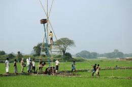
In the fall of 2023, a U.S. rover will land at the south pole of the moon. Its mission: to explore the water ice that scientists know lurks within the lunar shadows, and which they believe could help sustain humans who may one day explore the moon or use it as a launching pad for more distant space exploration.
NASA recently selected Kevin Lewis, an associate professor in the Krieger School’s Department of Earth and Planetary Sciences who has also worked on missions on Mars, as a co-investigator of the mission. Using part of the rover’s navigational system, he plans to explore the moon’s subsurface geology from his office in Olin Hall.
“I have been on other rover missions, but on Mars, so I’m a little bit new to the moon,” Lewis said. “We’re going to see into shadows that have never seen the sun, let alone been seen by humans. So it could be a very different type of surface than we’ve seen in other photos of the surface of the moon.”
Drier than a desert
Most of the moon is completely without water. That’s because of the way the satellite was formed, in a giant impact between the proto-Earth and a Mars-size object. Temperatures were high enough not only to melt rock, but to vaporize it, causing a cloud of rock vapor to orbit Earth. The vapor eventually coalesced to form the moon.
Those temperatures were also high enough to drive off any water, not even leaving appreciable traces trapped within rocks the way it is on Earth. But over time, meteors and comets containing water ice bombarded the moon, sending ice molecules hopping around the lunar surface.
The sun’s angle at the moon’s poles is steep, creating long shadows. This means that some of the polar craters receive no sunlight at all. When the water molecules happen to hop into one of those unlit areas, whose temperatures are among the coldest in the solar system at just tens of degrees above absolute zero, it drains their thermal energy and they remain stuck to the surface.
“So, over time, you could build up ice deposits in these permanently shadowed regions, which might be basically the only source of water on the entire moon in useful quantities,” Lewis said.
VTerrestrial and marine habitats have been considered the ecosystems with the highest primary production on Earth by far. Microscopic algae in the upper layers of the oceans and plants on land bind atmospheric carbon (CO2) and produce plant material driven by photosynthesis. Since sunlight does not penetrate into the subsurface, hardly any such primary production is to be expected.
However, genetic analyses of microorganisms in groundwater have indicated that even here many microorganisms are capable of primary production. In the absence of light, they must obtain the energy from oxidizing inorganic compounds, like from reduced sulfur of the surrounding rocks. However, the role of primary producers in the subsurface had never been confirmed before.
Groundwater is one of our most important sources of clean drinking water. The groundwater environment of the carbonate aquifers alone, which is the focus of the study, provides about ten percent of the world’s drinking water. With this in mind, the researchers carried out measurements of microbial microorganism carbon fixation in a subsurface aquifer, 5 to 90 meters belowground.
Surprisingly high primary production rates in total darkness
“The rates we measured were much higher than we anticipated,” says the first author of the study Dr. Will Overholt, Postdoctoral Researcher at Friedrich Schiller University Jena. “They equal carbon fixation rates measured in nutrient-poor marine surface waters and are up to six-fold greater than those observed in the lower zones of the sunlit open ocean, where there is just enough light for photosynthesis”.
Based on the measured carbon fixation rates, the researchers conservatively extrapolated global primary production in carbonate groundwater to be 110 million metric tons of carbon per year. Collectively, the net primary productivity of approximately 66 percent of the planet’s groundwater reservoirs would total 260 million metric tons of carbon per year, which is approximately 0.5 percent that of marine systems and 0.25 percent of global net primary production estimates.
“This may sound small but these measurements represent only our first estimate of what the true global value may be,” says senior author Prof Kirsten Küsel from the University of Jena and iDiv. “Since there is very little energy available in these nutrient-poor and permanently dark habitats, even a small percentage of the global primary production is a surprise.”
The researchers also sought to identify the microorganisms responsible for fixing carbon and generating new biomass within the aquifer. Metagenomic analyses point to a highly abundant microorganism not closely related to previously studied bacteria, within an uncharacterized order of Nitrospiria. “As food, these organisms are thought to form the basis of life for the entire groundwater ecosystem with all of its thousands of microbial species, similar to the role algae play in the oceans or plants on land,” says Overholt.
Unique method to measure primary production of microorganisms in aquifers
Measuring carbon fixation can be done with radioactively labeled carbon dioxide. “In carbonate rock environments, there is abundant dissolved CO2, that can make it difficult to directly observe rates of carbon fixation,” says Prof Susan Trumbore from the Max Planck Institute for Biogeochemistry in Jena. The team, therefore, used a special method to trace a small amount of labeled CO2 using highly sensitive accelerator mass spectrometry. “It is exciting to see what new insights these methods can lead to,” she says.
“Our findings offer new insights into how these subsurface ecosystems function, giving clues on how to monitor or remediate groundwater sources,” says Kirsten Küsel.
Poisonous algae blooms are becoming more common in the US, threatening water supplies and public health. But so far, there are few state or federal guidelines, and local water managers could use some help, a UConn-led team of researchers reports in the September 30 issue of Nature Sustainability.
A massive bloom of green-blue algae in Lake Erie in 2014 forced Toledo, Ohio to warn over half a million residents not to drink or even touch their tap water. It was one of the first times that algae bloomsmade national news, but it wouldn’t be the last. Since then, Salem, Oregon; Lake Hodges in California; and Lake Oneida in New York have had massive blooms. The toxins produced by such blooms can cause numbness, dizziness, convulsions, liver damage and even death.
“They’re nasty,” says Christine Kirchhoff, Associate Professor and Castleman Professor of Engineering Innovation in the Department of Civil & Environmental Engineering. Some of these toxins, such as liver-damaging microcystins and cylindrospermopsin, can be managed with combinations of chlorine and activated carbon. Other algae toxins like anatoxins and saxitoxins, which target the nervous system, are not easily removed by conventional water treatments. And you can’t boil them out of the water. So when a big algae bloom occurs in a reservoir, water managers can struggle to make sure the water is safe.
Kirchhoff and other researchers from UConn and the University of Michigan surveyed public water managers across the United States who manage systems that draw from inland lakes. Such lakes, even extremely large ones such as Lake Erie, are warming and may become more prone to algae blooms due to climate change.
More than half the water managers surveyed said their system had experienced a bloom of harmful algae at least once. Almost a third of the managers said they experienced them at least once a year, and 60% of those who’d had a bloom said they believed the problem was getting worse. Most water managers said they relied on their state agencies and professional associations for advice on how to handle harmful algae blooms in the water supply.
Unfortunately, a lot of state agencies don’t have that much to offer on the problem. States take their cues from the US Environmental Protection Agency (EPA), and currently EPA doesn’t regulate algae toxins under the Safe Drinking Water Act. Through the Unregulated Contaminant Monitoring Program, EPA did collect data from the treated water of a random sample of water systems across the US a few years ago, and the results showed limited occurrence of toxins in public water supplies.
Kirchhoff says the EPA survey aims to be nationally representative and so cannot rule out the potential for greater risk of toxic blooms at a state or regional level. The Connecticut Department of Public Health had a voluntary algae toxin testing program after the Toledo bloom raised concerns in the state. Systems that submitted voluntary samples for testing did not detect any toxins, and the testing program was discontinued.
Because cyanobacteria behavior is complex, monitoring for algal toxins is also complicated. Sometimes there is no visible bloom, but there are toxins present or there may be toxins in one part of a lake or at one depth and not elsewhere. For these reasons, “I would like to see a longer term, broader monitoring program that uses what we know now,” to determine areas at risk here in Connecticut and across the country, to better protect the public, Kirchhoff says.
A study has pinpointed the likely source of most natural gas contamination in drinking-water wells associated with hydraulic fracturing, and it’s not the source many people may have feared.
What’s more, the problem may be fixable: improved construction standards for cement well linings and casings at hydraulic fracturingsites.
A team led by a researcher at The Ohio State University and composed of researchers at Duke, Stanford, Dartmouth, and the University of Rochester devised a new method of geochemical forensics to trace how methane migrates under the earth. The study identified eight clusters of contaminated drinking-water wells in Pennsylvania and Texas.
Most important among their findings, published this week in the Proceedings of the National Academy of Sciences, is that neither horizontal drilling nor hydraulic fracturing of shale deposits seems to have caused any of the natural gas contamination.
“There is no question that in many instances elevated levels of natural gas are naturally occurring, but in a subset of cases, there is also clear evidence that there were human causes for the contamination,” said study leader Thomas Darrah, assistant professor of earth sciences at Ohio State. “However our data suggests that where contamination occurs, it was caused by poor casing and cementing in the wells,” Darrah said.
In hydraulic fracturing, water is pumped underground to break up shale at a depth far below the water table, he explained. The long vertical pipes that carry the resulting gas upward are encircled in cement to keep the natural gas from leaking out along the well. The study suggests that natural gas that has leaked into aquifers is the result of failures in the cement used in the well.
“Many of the leaks probably occur when natural gas travels up the outside of the borehole, potentially even thousands of feet, and is released directly into drinking-water aquifers” said Robert Poreda, professor of geochemistry at the University of Rochester.
“These results appear to rule out the migration of methane up into drinking water aquifers from depth because of horizontal drilling or hydraulic fracturing, as some people feared,” said Avner Vengosh, professor of geochemistry and water quality at Duke.
“This is relatively good news because it means that most of the issues we have identified can potentially be avoided by future improvements in well integrity,” Darrah said.
“In some cases homeowner’s water has been harmed by drilling,” said Robert B. Jackson, professor of environmental and earth sciences at Stanford and Duke. “In Texas, we even saw two homes go from clean to contaminated after our sampling began.”
The method that the researchers used to track the source of methane contamination relies on the basic physics of the noble gases (which happen to leak out along with the methane). Noble gases such as helium and neon are so called because they don’t react much with other chemicals, although they mix with natural gas and can be transported with it.
That means that when they are released underground, they can flow long distances without getting waylaid by microbial activity or chemical reactions along the way. The only important variable is the atomic mass, which determines how the ratios of noble gases change as they tag along with migrating natural gas. These properties allow the researchers to determine the source of fugitive methane and the mechanism by which it was transported into drinking water aquifers.
The researchers were able to distinguish between the signatures of naturally occurring methane and stray gas contamination from shale gas drill sites overlying the Marcellus shale in Pennsylvania and the Barnett shale in Texas.
The researchers sampled water from the sites in 2012 and 2013. Sampling sites included wells where contamination had been debated previously; wells known to have naturally high level of methane and salts, which tend to co-occur in areas overlying shale gas deposits; and wells located both within and beyond a one-kilometer distance from drill sites.
As hydraulic fracturing starts to develop around the globe, including countries South Africa, Argentina, China, Poland, Scotland, and Ireland, Darrah and his colleagues are continuing their work in the United States and internationally. And, since the method that the researchers employed relies on the basic physics of the noble gases, it can be employed anywhere. Their hope is that their findings can help highlight the necessity to improve well integrity.
With increased drought coverage from newspapers, water conservation increased in the San Francisco Bay Area during the drought that ended in 2016. That’s according to a new study from Stanford researchers that links real water consumption data with the public attention garnered by California’s recent droughts.
“A number of waterutilities that we work with observed unprecedented and unexpected water conservation levels during the recent drought in California compared to previous ones,” said hydrologist Newsha Ajami, who directs Urban Water Policy and Innovation research for Stanford’s Water in the West program. “We were curious to see what was prompting this level of public response, especially before the 2015 conservation mandate went into effect.” Ajami wondered if the heightened news coverage of the most recent drought might explain some of this behavior.
In an attempt to answer those questions, graduate student Kim Quesnel worked with Ajami to develop models examining conservation in different water districts throughout the Bay Area. She also worked with a team to develop a search algorithm to quantify drought coverage by state and national news outlets. The group’s results, published Oct. 25 in the journal Science Advances, show the relationship between media coverage and water savings, in some cases at the level of household smart meters.
In California, water has long been a vital political and practical problem. California’s vast agriculture industry requires irrigation for crops and drinking water for livestock; at the same time, growing cities need water for drinking, washing, and landscaping. Results from this study could help the state realize the importance of encouraging water efficiency and conservation.
The power of online tools
The research team created a novel web-scraping and search algorithm, nicknamed Articulate, to quantify the drought-related coverage from nine major national and California-based newspapers between 2005 and 2015. This period encompassed the majority of the two most recent California droughts in 2007-2009 and 2011-2016. They compared their algorithm’s results with Google Trends, a free online tool that showed the number of drought-related searches performed by Bay Area residents. The level of media attention to drought conditions closely matched the fluctuations in the public’s awareness and curiosity.
The first drought period saw barely any publicity or increased web searches. “There were other things on people’s minds,” said Quesnel, referring to a historic election season and the Great Recession, both of which dominated media coverage at the time. The second drought, however, generated hundreds of news articles per month describing dry conditions, historic mandatory water conservation measures and rising water prices statewide.
Quesnel compared the water demands of single-family households in the Bay Area to factors including unemployment, weather, household income and, of course, media coverage. From her models, she found that economic hardship from the high unemployment rates during the Great Recession correlated with water savings during the first drought. In both droughts, higher summer temperatures corresponded to higher seasonal water use. Strikingly, their models also found that for every 100-article increase over a two-month period, there was an 11 percent to 18 percent decrease in demand for water. With an enormous spike in media attention during the second drought, water savings across all studied areas were dramatic.
Web portal
The question for the team was whether these changes would last.
“In arid and semi-arid places like California, over half of the water use in single-family homes is outdoors, for landscaping, so a lot of this change could have been due to households choosing to not water their lawns a few times per week, for example, or to more permanent changes such as residents removing their lawns completely,” Quesnel said.
“Some of the short-term water saving behaviors prompted by the drought might just vanish,” said Ajami, who is also a senior research scientist with the Stanford Woods Institute for the Environment.
Their group recently created a web portal that allows people to interact with drought data, watching district-level water usage in addition to tracking drought-related media and public interest. Since the time period studied in this paper, the drought has been declared over. Longer-term changes like replaced appliances, drought-tolerant landscaping and gray water systems remain, but mandatory water restrictions have been rescinded, media coverage has declined and water use has rebounded in many of the areas studied.
Despite the rebound, Ajami said this research suggests people do respond to information in the media. “If you provide the right set of knowledge and information to consumers, they do actually react and respond to that message. The drought really raised the profile of water issues faced by the state, an invaluable outcome,” Ajami said.
As the first heavy rains of the season poured across the Santa Cruz Mountains last month, emergency responders and residents braced for debris flows, road closures and power outages.
Others also feared for their drinking water. These included Boulder Creek resident Dan Fitzpatrick, who amid the downpours pictured the rain washing over burned-out neighborhoods and into the catchment system of his water provider.
“Every storm that has occurred since the fire has caused the water to run black for a few days, so I know runoff is making it into the water,” said Fitzpatrick, a former member of his water district‘s engineering committee.
While noting that burnt vegetation causes much of the black gunk, he added that there is “probably more than just carbon in that soot.”
Across the West, water districts are grappling with new and increasingly common challenges as fire seasons grow longer and blazes consume more suburbs and smaller communities. These fires are not only destroying people’s homes and treasured possessions, they are leaving behind an array of incinerated plastics, lead, pesticides and other toxic particles that have the potential to contaminate water supplies.
Though water managers in the Santa Cruz Mountains say their supplies are safe—before heavy rains, they start pumping groundwater instead of relying on catchment water or supplies from the San Lorenzo River—scientists say this new field of environmental concern deserves more attention.
“We’re really on the ground floor when it comes to the effects of fire on municipal water supplies in this urban wildfire nexus,” said Fernando Rosario-Ortiz, director of the environmental engineering program at the University of Colorado in Boulder. “We are learning that there’s a lot we really don’t know.”
Drinking water was polluted after the 2017 Tubbs fire in Sonoma and Napa counties and the 2018 Camp fire that devastated the town of Paradise. High levels of benzene, a recognized carcinogen, were found in drinking water in both fire zones.
Months before the rainy season, the CZU August Lightning ComplexfFire had battered water districts in the Santa Cruz Mountains, a rugged stretch of redwoods between the Pacific Ocean and Silicon Valley. The blaze, which burned for 38 days, killed one person, burned 86,509 acres, destroyed more than 1,400 structures and damaged drinking water infrastructure.
For weeks, residents in Boulder Creek, Ben Lomond and Felton were without drinking water. In some areas—particularly those close to Big Basin Redwoods State Park, and served by the smaller Big Basin Water District—residents didn’t get water back until early January.
“In the early stages, we were not even maintaining fire flow,” said Rick Rogers, general manager of the San Lorenzo Valley water district, explaining how water was unavailable for firefighting. “We just had enough for critical, potable water.”
Damien Moore, general manager for Big Basin, declined an interview, explaining that he was busy in the field, maintaining water flow to his customers.
Burnt piping and equipment, as well as potentially contaminated supplies, were largely to blame for the water shortage. In the case of San Lorenzo Valley Water, five out of the six water intakes in the upper part of the district were destroyed, as was half of its storage infrastructure.
Most of that has been since been restored, said Rogers, but not without putting strain on the system.
During a typical year, the system relies on both ground and surface water, in a roughly 50-50 split.
During the wetter winter months, surface water is preferred—it is plentiful and clean-tasting, Rogers said. Before big storms, however, those systems are temporarily shut down as the water becomes turbid and cloudy after it rains, making it difficult to treat and disinfect.
As spring moves into summer and surface water sources diminish, the district looks to its underground reserves. But relying too much on those supplies—as occurred this year—creates its “fear factor,” Rogers said.
Groundwater reserves require continuous pumping to run, which strains the small district’s engineering and maintenance crew. In addition, groundwater reserves are not limitless—a concern as the region heads into another dry winter with rain levels far below normal.
More rain is expected in the Bay Area this weekend, and though that could be good for water supplies, it adds to the risk of mudslides, blocking access for water district workers.
Three years ago, district engineers discovered one of the access roads sat atop a “considerable” ancient landslide, where the ground movement is 80 feet below the surface. That’s required an expensive $15-million repair that the district is only now beginning to address.
Continuing rains also could further spread contamination on the ground.
Although Phase I of the EPA’s fire and debris removal is complete in the region, Phase II has only just begun, leaving behind sources of toxic chemicals that could wash into catchment systems designed to collect rainwater.
Nate Gillespie, the district’s supervisor for water treatment systems, says the district checks for these pollutants. The most recent tests, which the district received Feb. 9, showed “non-detect” levels for volatile organic compounds, the pollutants of concern.
But it’s unclear how long some of the pollutants can linger, how they mobilize in surface waters or in storage, and how mild turbidity after a rain can affect the disinfection process.
“The reality is that water-quality research has really lagged,” Rosario-Ortiz said. “We’re really only just beginning to understand what is happening.”
The good news is that water districts across much of the West are talking to one another and sharing best practices.
“We’re learning from the folks in Sonoma and Paradise,” Rogers said.
Researchers in MIT’s Department of Civil and Environmental Engineering believe they have pinpointed a pathway by which arsenic may be contaminating the drinking water in Bangladesh, a phenomenon that has puzzled scientists, world health agencies and the Bangladeshi government for nearly 30 years. The research suggests that human alteration to the landscape, the construction of villages with ponds, and the adoption of irrigated agriculture are responsible for the current pattern of arsenic concentration underground.
The pervasive incidence of arsenicpoisoning in Bangladesh and its link to drinking water were first identified in the scientific literature in the early 1980s, not long after the population began switching from surface water sources like rivers and ponds to groundwater from newly installed tube wells. That national effort to decrease the incidence of bacterial illnesses caused by contaminated drinking water led almost immediately to severe and widespread arsenic poisoning, which manifests as sores on the skin and often leads to cancers of the skin, lung, liver, bladder and pancreas.
Since then, scientists have struggled to understand how the arsenic, which is naturally occurring in the underground sediment of the Ganges Delta, is being mobilized in the groundwater.
By 2002, a research team led by Charles Harvey, the Doherty Associate Professor of Civil and Environmental Engineering at MIT, had determined that microbial metabolism of organic carbon was mobilizing the arsenic off the soils and sediments, and that crop irrigation was almost certainly playing a role in the process. But the exact sources of the contaminated water have remained elusive, until now.
In a paper appearing online in Nature Geoscience Nov. 15, Harvey, former graduate students Rebecca Neumann and Khandakar Ashfaque and co-authors explain that ponds excavated for the purpose of providing soil to build up villages for flood protection are the source of the organic carbon that presently mobilizes the arsenic in their 6-square-mile test site. The carbon settles to the bottom of the ponds, then seeps underground where microbes metabolize it. This creates the chemical conditions that cause arsenic to dissolve off the sediments and soils and into the groundwater.
The researchers also found that in their test area, which is flooded by annual monsoons, the rice fields irrigated with arsenic-laden water actually serve to filter out much of the arsenic from the water system.
“Our research shows that water from the ponds carries degradable organic carbon into the shallow aquifer. Groundwater flow, drawn by irrigation pumping, transports that pond water to the depth where dissolved arsenic concentrations are greatest and where it is then pumped up into the irrigation and drinking wells,” says Harvey. “The other interesting thing we found is that the rice fields are a sink of arsenic — more arsenic goes in with the irrigation water than comes out in the groundwater.”
In 2020 wildfires ravaged more than 10 million acres of land across California, Oregon and Washington, making it the largest fire season in modern history. Across the country, hurricanes over Atlantic waters yielded a record-breaking number of storms.
While two very different kinds of natural disasters, scientists say they were spurred by a common catalyst—climate change—and that both also threaten drinking water supplies. As the nation already wrestles with water shortages, contamination and aging infrastructure, experts warn more frequent supercharged climate-induced events will exacerbate the pressing issue of safe drinking water.
It’s no surprise then that the Biden-Harris administration has identified safe drinking water as one of the nation’s top priorities. Below, Stanford water experts Rosemary Knight, Newsha Ajami and Felicia Marcus discuss safeguarding drinking water from climate-driven disasters; emphasizing a modern approach to infrastructure investments; and focusing on watershed and water source protection. Knight is a professor of geophysics in the Stanford School of Earth, Energy & Environmental Sciences (Stanford Earth); Ajami is director of urban water policy with Stanford’s Water in the West program; and Marcus is the William C. Landreth Visiting Fellow at Water in the West.
Whether it’s floods, fires, storms, droughts or sea level rise, climate impacts have a direct influence on water supplies. What types of climate mitigation policies should the Biden team enact to protect drinking water?
Marcus: Grants and low-cost financing for community preparedness, especially for underserved communities, to adapt and plan for climate impacts would make a tremendous difference. The federal government should be doing leading-edge research, technology development and dispersion for lower-cost sensor and treatment systems for drinking water. Finally, the administration can explicitly make drinking water its highest priority for research and development, funding, and updating regulations based upon science.
Ajami: Water has to be the central part of both climate mitigation and adaptation discussions. Today we are facing many challenges that are the consequence of our approach to securing water and energy resources over the 20th century, building infrastructure networks under the assumption of abundance and overlooking inherent environmental interlinks. Source protection, demand management and public engagement strategies should be at the center of any climate policy.
News stories, such as the lead contamination of Flint, Michigan’s water in 2014, have shown failing or poorly managed infrastructure is at the heart of the potable water crisis. What types of infrastructure investments are key to ensuring access to safe water? What should the Biden team do to spur change?
Ajami: There are multiple challenges at play here: aging infrastructure, lack of infrastructure, cost of service, infrastructure operation and maintenance costs, and navigating impacts of climate change. The new administration has the opportunity to address many of these challenges through a holistic effort and having a systems-level approach by investing in water diversification strategies, multi-benefit and decentralized infrastructure (including green infrastructure, stormwater capture and reuse), and data and governance systems for innovative infrastructure solutions.
Marcus: A short list would include upper watershed protection to protect source waters; better treatment systems all along a watercourse, as communities take out and then return water through wastewater systems and natural treatment systems; basic financing for communities that can’t afford adequate drinking water systems; and support for changing out lead piping and faucets in schools and homes. Funding, better regulation and communication can make a world of difference.
Groundwater supplies drinking water to 99 percent of rural populations, but overpumping has led to aquifer depletion and water contamination. What federal and state actions can alleviate growing pressures on groundwater?
Knight: We need to change our approach to land use planning by recognizing that the most valuable use for some land is to become a site for managed recharge of the underlying groundwater system. Getting more water into regions below the ground increases the amount of stored water and can help prevent subsidence. The challenge is identifying the optimal locations for recharge zoning and requires seeing below the ground to find coarse-grained materials, such as sand and gravel, that can act as fast paths to move the water from where it is at the surface to the required depths for recharge. This is an area of work I’m currently focused on and it presents great potential to replenish and grow groundwater reserves.
Ajami: I see our groundwater supplies as our social security system; we all contribute and withdraw from it at different times. Unless we collectively contribute to it and protect it from degradation and contamination, there will be none left for future generations to draw from. I believe collaborative governance and land use management are the two most important parts of achieving groundwater sustainability, and neither can work without reliable data sources and accounting mechanisms.
Are there any technological innovations that could dramatically advance water treatment, monitoring or recharge?
Knight: We now have geophysical systems, deployed using helicopters or towed behind ATVs, that can provide fantastic underground images, mapping out fast paths for groundwater. Last month we flew along the base of the Sierra Nevada in Tulare and Fresno counties, looking for these fast paths at the mouths of rivers coming out of the mountains. The recent advancements in geophysical technology and our ability to process and interpret the acquired data position us to move forward aggressively with a new approach, where zoning for recharge becomes an integral part of land use planning. This approach could be implemented throughout California.
Ajami: I do not believe our problem currently is lack of technological advancement but our outdated and fragmented governance structure, regulatory process, rigid laws, and obsolete business models and practices skewed toward gray, once-through, centralized infrastructure systems. Any advancement that can overcome these challenges can open up opportunities for innovative 21st-century solutions to be incorporated into our existing aging centralized water systems. Investing in soft infrastructure including data systems, IT infrastructure, digital solutions, new models or decision support tools, and updated performance measures are key in this process of shepherding the paradigm shift in the water sector and providing equitable access to safe drinking water.
Every year, an explosion of microscopic life reigns over western Lake Erie, forming a green slick of algae and bacteria so massive and vibrant that it can be seen from space.
The harmful algae bloom slimes fishing boats, paints beaches in toxins and engulfs water intake cribs. In 2014, it left 400,000 people without drinking water for three days after toxins infiltrated Toledo’s water system. Then-Gov. John Kasich declared a state of emergency and called in the National Guard to distribute bottled water in an incident that served notice that drinking water from Lake Erie was in peril.
This year, the bloom was among the most severe and toxic since scientists began keeping track in the early 2000s. At its peak, it coated around 620 square miles of Lake Erie’s surface waters, an area more than twice the size of Chicago, according to satellite imagery. The sheer weight of blue-green bacteria making up the bloom—forecast to be around 46,000 metric tons—was expected to be a new record.
“If you did a Google image search for “Toledo water,” what would pop up is the Toledo skyline where the Maumee River looks like the Chicago River on (St. Patrick’s Day),” Mayor Wade Kapszukiewicz said. “The only difference is we didn’t put any dye in it.”
Climate change is jeopardizing two of the most precious resources the Midwest possesses: food and water, according to federal studies. Greater rainfall and more powerful storms are eroding some of the richest soils in the United States and, in doing so, washing bloom-inducing fertilizers from farm fields into Lake Erie. More frequent torrential downpours are also overpowering antiquated sewer systems at times, releasing a profusion of raw sewage into waterways, further polluting and degrading water quality.
Meanwhile, warmer temperatures are allowing the microbes within algae blooms—particularly the toxin-producing bacteria—to flourish in greater numbers and for more months of the year, posing elevated and prolonged risks to drinking water, wildlife and the $15.1 billion tourism industry along Ohio’s coastline.
The Great Lakes are all connected and collectively hold 20% of the world’s fresh surface water, but each lake has unique features—depth, shape, size and surroundings—making them vulnerable to different aspects of climate change.
Algae blooms occur annually across the region in shallow, sheltered waters like Saginaw Bay in Lake Huron and Green Bay in Lake Michigan. A large algae bloom even developed once in the normally pristine waters of Lake Superior near the Apostle Islands, a harbinger that no environment is immune.
The danger is most acute in Lake Erie—the shallowest, southernmost and warmest of the Great Lakes—which is a natural incubator for these colonies of microorganisms.
While countries across the globe face drought and water insecurity, it’s a bitter irony that some communities sitting on the edge of the planet’s largest system of freshwater—more than 11 million people depend on Lake Erie for drinking water—are compelled to buy bottled water.
“As population explodes, water is going to be the most valuable resource on planet Earth by the end of this century. It therefore represents the greatest advantage that this part of the country has. This region—the Great Lakes region, the Snow Belt, the Rust Belt, whatever you want to call it—has faced hard times over the last 50-60 years,” Kapszukiewicz said. “But … if we can hold on, we may be the most valuable part of the country. Frankly, with what we have, (the Midwest) could be Saudi Arabia in 100 years. We just can’t squander it.”
Billions of dollars have been spent monitoring Lake Erie’s water quality, overhauling drinking water treatment and reducing sewage outflows. But the biggest contributor to these blooms—agricultural runoff, which is responsible for up to 89% of the phosphorus flowing into Lake Erie—remains largely unregulated.
“The amount of manure from pigs, chickens and cows that goes into the western basin, that seeps untreated directly into Lake Erie, is roughly equivalent to all human waste from the cities of Chicago and Los Angeles combined,” Kapszukiewicz said. “That’s just how much animal manure is going in untreated—I’m not even talking about what they spray on crops. This is why we’re living in the world we’re living in.”
The 1,500 square miles surrounding the Maumee River was once known as the Great Black Swamp, a marshland that fostered a wealth of wildlife and naturally filtered nutrients through plant roots.
When European settlers arrived in northwest Ohio in the early 1800s, they gradually drained the swamp, converting it to farmland and introducing the livestock that would produce a concentrated source of manure. Nearby cities boomed in size, not only pumping their own sewage waste into the rivers, but also adding in phosphate laundry detergents before they were banned nationwide in 1994.
In the ’60s and ’70s, Lake Erie was so rife with nutrient pollution it was declared “dead.” Under the Clean Water Act, implemented in 1972, the U.S. cracked down on municipal wastewater treatment facilities, industrial polluters and other contributors. And, for a while, the algae blooms subsided.
In the past two decades, however, the blooms have returned as large as ever.
Scientists say Lake Erie has endured harmful algae blooms historically, but the modern-day magnitude is believed to be increasing as a result of human activities and climate change.
Each year, as melting winter snowpack and spring rains cascade over the rural landscape of northwestern Ohio, a torrent of water flushes an unfathomable amount of manure and commercial fertilizer from farm fields into the Maumee River, a 137-mile waterway carrying waste from Fort Wayne, Indiana, to Toledo, and eventually flowing into the shallowest end of Erie. Meanwhile, throughout the year, Detroit routinely pumps wastewater and sewage into its namesake river, as do other major metros.
These rivers become fuses as fecal-laden waters plunge into western Lake Erie. Nutrients—particularly phosphorus—trigger an eruption of microscopic algae, according to Chris Winslow, director of the Ohio Sea Grant, a research and education collaborative led by Ohio State University.
Just as humans need vitamins to grow, so does algae. Iron, potassium and nitrogen are essential and available in ample amounts. Human and animal excrement contain the missing ingredient: phosphorus.
“You bump up the phosphorus, and they are just waiting to capitalize off of it,” Winslow said.
An analysis of aerial photographs and state permit data identified 775 hog, cattle, dairy and poultry operations in the Maumee River watershed in Ohio, Indiana and Michigan in 2018—a 42% increase since 2005, according to a report by the Environmental Law and Policy Center and the Environmental Working Group, nonprofit advocacy groups. Of the large-scale “factory farms” in the watershed, more than a quarter had expanded since being built. Although the Maumee only contributes 5% of the water entering Lake Erie, it is so loaded with phosphorus that it is the main driver of the algae blooms.
The most potent form of phosphorus, unblended with soils, acts as a catalyst for blooms each year. The amount of this full-strength phosphorus has increased 140% since 1990. Some experts suspect this can be attributed to a change in farming practices, namely no-till farming—a technique intended to curb soil erosion, but one in which layers of manure piled on top of farmland are more easily carried away by heavy rains.
Winslow said other factors are also at play.
“We have zebra mussels in our lake filtering the water differently than 40 years ago,” he said. “We have larger farm operations. We have increased rainfall and runoff to take nutrients from the land into the water. We have warmer temperatures, and these organisms like warmer temperatures. Some of these things have more of an impact than others, but there’s a lot of moving parts.”
This fall, the Ohio countryside was a desolate mud pit marked by rampant weeds, standing water and stunted crops.
Over 880,000 acres intended for corn and nearly 600,000 acres for soybeans were left barren this year, as farmers opted to take insurance money rather than risk a meager harvest.
Ty Higgins, spokesman for the Ohio Farm Bureau, described rural Ohio this fall as the “end of the world.”
Farmers, he said, can use drought-resistant corn. They can plant strains that perform better in heat. But there’s no silver bullet for rain.
“That’s one curveball Mother Nature can throw farmers that they don’t have a workaround,” Higgins said.
Climatologists say the region has become soggier.
A spike in greenhouse gases, largely from man-made carbon emissions, has driven global temperatures upward, according to the National Oceanic and Atmospheric Administration. For every degree of warming, the atmosphere can hold 4% more moisture, which can translate into heavier and more severe downpours.
Since 1951, the Great Lakes region has seen a 2.3 degree rise in temperatures, a 14% uptick in annual precipitation and a 35% increase in the most intense storms. In the past year, the rain, snow and flooding across the Midwest was one for the record books.
Between September 2018 and August 2019, the Buckeye State endured the wettest 12 months on record since NOAA began keeping precipitation statistics in 1895.
Chris Weaver, 45, of Lyons, was one of the few who decided to plant this year—not that he had much of a choice. His family-owned dairy peddles three commodities: milk, meat and manure. With 3,000 cows on one farm in Williams County, his employees work around the clock corralling cattle into milking stalls. He depends on 5,000 acres of cropland for feed.
And each fall, Weaver draws from a manure pond the size of a football field to fertilize his land.
Manure, some might argue, is the greatest commodity for farmers with livestock. Not only does it benefit crop growth, the excess can be sold. Weaver charges about $400 to cover an acre.
“Grandpa always told me, “It smells like money to me,”” said Higgins, the farm bureau spokesman.
In the fall of 2018, because of the onslaught of rain, most farmers didn’t get a chance to put fertilizer down. Those who did witnessed that money carried downstream in this year’s spring rains.
It wasn’t until July 1, about two months later than normal, that Weaver was able to get most of his corn, soybean and alfalfa crops in the ground. Weaver had some reserves to feed his cattle but not enough to make it a whole year without a harvest.
He was still anxiously monitoring the weather throughout the fall, praying there wouldn’t be an early frost. He managed to reap his corn by mid-October while his soybeans withstood several inches of snow in November. The harvest, he said, would be enough to make it without buying reserves.
“It has to be a one-off,” Weaver said, almost as if trying to convince himself. “We’ve had a lot of wetter years. But if it happens again next year, I’m going to really be scratching my head about what I’m doing.
“It’s hard to imagine,” he said, with his voice trailing off. If July 1 became the start of planting season, “I don’t think we’d ever have corn here ever again.”
In addition to sweeping manure and commercial fertilizer into waterways, the rain turns soil into claylike mud that prevents oxygen from reaching crop roots, killing the plants. Soggy soil also makes the land harder to tend, because large farms require heavy machinery, including tractors, prone to getting stuck in the muck.
Some farmers plant cover crops, such as peas and oats, in the fall to help absorb moisture from saturated soils and hold the nutrients from fertilizer in place. The problem is, these crops don’t offer much of a return on investment. And, at the end of the day, farming is a business.
Weaver, however, sees other benefits beyond the monetary value. His in-laws live in the Toledo area and go camping each year near the lakeshore. It’s also where he goes walleye fishing.
“Overall it’s something where maybe I’m breaking even, but I’m doing something to help the environment,” Weaver said. “I think every farmer is recognizing that (cities like Toledo) are affected, that they have to do better.
“We’re only an hour from Lake Erie, so it’s our backyard too.”
But Weaver is in the minority. According to the U.S. Department of Agriculture, cover crops were used on less than 10% of cropland in Ohio in 2017.
Downstream, the Toledo area braces each year for verdant, bacteria-choked waters, no-swim advisories at beaches and noxious odors from scummy bays.
The morning of Saturday, Aug. 2, 2014, Crystal Jankowski, nearly nine months pregnant, awoke before dawn and noticed a number of missed calls from family members. Jankowski, whose father was ailing from liver and kidney failure, feared grim news about his condition.
Instead, Jankowski was jolted by ominous instructions from her mother: “Tell Josh to go find water—now! There’s something wrong with the water.”
More than 400,000 people and hundreds of businesses adjacent to the world’s 13th largest lake suddenly found themselves without potable water.
The culprit was Microcystis aeruginosa, a blue-green cyanobacteria known to create a toxin more lethal than cyanide or antifreeze. Its poison, which can cause liver failure, was so efficient at killing animals that scientists originally termed it “fast death factor.” In one of the most deadly episodes, more than 50 people died in Brazil in 1996 when hospital patients were exposed to unfiltered water containing the toxin. Scientists say no deaths attributed to these toxins have been reported in the U.S.
In Toledo, the bloom had drifted from Maumee Bay and engulfed the city’s water intake 3 miles offshore and then stalled, leaving the neon green bloom to linger for days.
At the treatment plant, a lab test showed an alarming result: The drinking water had been compromised.
Following the historic shutdown, Ohioans went on a maddening search for water, many crossing state lines.
Josh Jankowski moved through the crush of people rummaging barren grocery store aisles. Nearly three hours later, he returned with a package of baby wipes and a bottle of Pedialyte.
Not long after that, Crystal Jankowski began having contractions. The couple rushed to the hospital, where the emergency room was abnormally busy for a Saturday morning.
“Everyone thought they were sick. They had woken up, drank their coffee, took a shower. And then the morning news told people not to drink the water, and, if you did, here are the symptoms,” she said.
Lakes, rivers and some private wells are becoming saltier, largely thanks to high levels of road salt sprinkled on streets during winter. According to an article in Chemical & Engineering News (C&EN), the weekly newsmagazine of the American Chemical Society, this situation could cause harm to wildlife and humans.
Contributing editor Deirdre Lockwood notes that scientists have found greatly increased amounts of chloride in streams, lakes and rivers over the last few decades. One of the biggest culprits is salt that’s deposited onto roads before and during snowstorms. The amount used in the U.S. has grown dramatically from about 4,500 metric tons in the early 1940s to 22 million metric tons now. But salt also comes from sewage, fertilizer runoff, mining operations and deteriorating structures. Not only does all of this salt makes water taste bad, it can corrode plumbing and cause health concerns. It also can affect freshwater organisms and disrupt ecosystems.
Some scientists are calling for the U.S. Environmental Protection Agency to start regulating salts. Others are simply trying to bring more attention to this issue. And some municipalities are already implementing changes. In Madison, Wisconsin, crews apply brine, about a 20 percent salt water solution, onto roads before a snowstorm hits. With this approach, they have used about 70 percent less road salt. And the village of Lake George, New York, has reduced roadsaltapplication by about 30 percent with brine treatment and new, more effective snow plows.