California has taken a big step towards boosting how much sewage water local governments can purify and reuse for drinking — a process known as water recycling. On Tuesday, the state proposed draft regulations to expand recycling by introducing new purification standards and processes.
Why now: California law currently doesn’t allow cities to put recycled wastewater directly into municipal water distribution systems. Instead, cities are required to first inject that water underground into an aquifer, where further, natural filtration occurs.
What’s proposed: These new regulations would allow putting recycled water directly into the local water system, allowing more cities to recycle water that don’t happen to have an underground basin to store water, or don’t have enough space in groundwater basins because of past pollution, which is the case in L.A.
Why it matters: The climate crisis is driving longer and more extreme droughts, pushing our already overstretched water supplies to the brink. Recycling more water for drinking is one way Southland cities are working to lessen reliance on imported water from the Colorado River and northern California.
What’s next: The State Water Board will hear feedback on the regulations and plans to consider adoption of final regulations before the end of the year. See current recycled water projects in the state here.
By Jennifer Möller-Gulland with J. Carl Ganter and Cody T. Pope
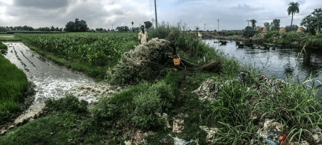
BENGALURU, India – In a small town in the suburbs of this booming city, K.V. Muniraju knows all too well the decade-old battle of securing water for his crops. With groundwater tables continuously falling, the middle-aged farmer once borrowed heavily to dig wells ever deeper.
If he was lucky, he found water. If he was unlucky, he didn’t. If he was really unlucky, he found a hint of water and proceeded to invest in the well infrastructure, only to see the well run dry and trap him in debt.
That happened to Muniraju in 1994 and 1995, when he was forced to direct water into his fields from nearby storm water drains.
Then came apparent salvation. In 1998 the nearby town installed a sewer system and discharged the untreated wastewater through the same storm water drains alongside his fields. In the 20 years since, Muniraju has had a secure water source to grow his crops.
The steady water supply, though it reeks, also contains high nutrient concentrations. That enables Muniraju to increase production while reducing input costs, such as fertilizers. His standard of living has increased – he built a stone house and sent his three sons and two daughters to school and college.
Across India, and particularly in the nation’s big metropolitan regions, countless numbers of farmers like K.V. Muniraju raise their crops with untreated wastewater. Medical specialists say farmers and their families risk serious disease from exposure to harmful sewage-borne microorganisms and metals. Scientists have measured unsafe levels of heavy metals and other toxic substances in Indian crops – posing a public health threat if consumed.
Indian public health and safety authorities have displayed limited action in tackling the impending public health crisis. Just 30 percent of wastewater undergoes any sort of treatment before being discharged in a wretched stream of industrial effluent that contains heavy metals and toxic chemicals. To date there is no regulatory framework for testing primary products, such as vegetable and fruits, for toxic contaminants. The widespread use of untreated wastewater – particularly in urban and peri-urban areas – to grow a considerable portion of India’s food supply, coupled with current inaction from officials, has converged to produce, say some scientists, a toxic time bomb in a nation that soon will overtake China to become the world’s largest.
“It is a complex nexus,” said Sumit Kumar Gautam, an environmental scientist at the Center for Energy, Environment, and Water (CEEW) in New Delhi. “If surface water is contaminated with untreated effluent, farmers use this for irrigation. The farmer is exposed to all contaminants and is likely to experience diarrhoea, bronchitis, skin diseases, eye irritation etc. The contaminants enter the soil, the biomass and thus enter the food chain. The entire food chain is contaminated because of this untreated effluent.”
The motivation for farmers to use wastewater to raise their crops is plainly evident in a convergence of three primary nation-testing challenges – rapid population growth and urbanization, increasing demand for food, and seriously depleted reserves of clean water.
Driven by economic opportunities, India’s megacities are growing fast. A 2010 study by McKinsey estimated that urban expansion is projected to happen twice as quickly as in the past – unlike any urbanization India has seen before – with 590 million people living in cities by 2030, or 170 million more than today.
But the supply of clean fresh water to produce food is diminishing. Rivers and lakes are profoundly polluted, according to state and government studies. And groundwater reserves are shrinking fast from over pumping. Fresh water scarcity is made worse by deep and lengthy droughts that grip India with increasing regularity and ferocity. According to the latest assessment by the National Institution for Transforming India (NITI), 70 percent of the country’s fresh water – in the ground or on the surface – also is contaminated.
Fresh water, in sum, is in the worst condition in India’s history, according to the NITI report that was released in June by Nitin Gadkari, minister of water resources. India, said the study, was snared in “the worst water crisis” in its history. The report found that at least 600 million Indians – almost half the country – contend with high or extreme water stress.
The single water supply that is still plentiful, though, is a stream of treated and untreated municipal and industrial wastewater.
Digging Deeper Into Food Supplies
The Hindon River, once the lifeline in one of the most fertile and productive agricultural regions in northern India is now one of the most polluted stretches in the Ganga Basin due to the discharge of untreated, highly polluted industrial, municipal and agricultural wastewater. Key industries upstream include paper mills, sugar processing and associated alcohol distilleries, as well as dairies, textile factories, tanneries, and informal battery manufacturing units. While it is mandatory to treat industrial effluent, water pollution levels show that this is not adhered to, nor enforced.
Krishan Pal Singh, an environmental activist in Doula Village remembers when farmers could safely use surface water to irrigate. That was before the 1980s. Then industries settled in the region and abstracted groundwater and polluted surface water.
The cocktail of heavy metals and pesticides carried by the Hindon have accumulated in the river sediments and seeped into the ground. Now groundwater is polluted, too. A study in 2009 found manganese, lead, zinc, copper, chromium, iron, and elevated levels of cadmium in river sediments. The industrial wastes aggravate any potential measures to clean the Hindon and reverse the decades-old contamination.
Downstream in Muzaffarnagar, an industrial city, the Hindon River is a pitiful sight. It looks more like a sewage canal than a river. Its stench is overwhelming. A mass of solid waste in the river forms a dam, limiting its flow. Dogs roam the landfill, happily picking up pieces of meat discharged by a slaughterhouse upstream. Along the river banks, farmers harvest corn. “The water is so polluted, we can only grow resistant crops,” said one farmer. “Half of our chili plants have diseases and at times the industries discharge acid, which damages the crops. If we use river water or not – we always lose.”
A bit further downstream, farmers transplant rice paddies, standing knee deep and without any protection in untreated wastewater. The head farmer explained that skin diseases are an issue at times. But he appreciates the fertilizing qualities of the untreated wastewater and the money he saves.
Further downstream, farmers from the village of Surana in the Bagpat district, said that surface water is of such bad quality that crops are of bad quality now, too. While they have no means of testing their water or crops for toxins, they realize that the quality of crops worsen with greater proximity to the river.
The farmers link the increased rate of diseases, particularly skin diseases, to the deteriorating water quality. “Kids are born healthy, but fall ill very quickly afterwards,” one farmer said. “Over time we realized that some crops are riskier to consume than others. Lentils seem to be less contaminated, so we eat them. Other vegetables, such as cauliflower, okra, and aubergine seem more contaminated. We believe they are unfit for consumption, so we don’t eat them. We sell them to the markets in Delhi.”
Bengaluru’s Foaming Lakes
Bengaluru was previously known for its beautiful lakes, which also served as lifeline for the city by collecting monsoon water and providing clean drinking water during the dry season when all rivers went dry. Today, the lakes are full of wastewater.
Bellandur Lake and Varthur Lake have gained international attention for frothing and catching fire as a result of untreated wastewater discharges. The wastewater contains nitrogen, phosphorus and carbon. It also contains sodium, potassium, calcium, and magnesium. The chemistry causes foam to form and accumulate.
Like a giant, smelly bathtub, big balls of snowy white suds roll across the water. The suds sometimes grow to be 30 to 40 feet high and, in a blizzard of bubbles, have even stopped traffic on the decaying bridge that spans the river. The suds are a soup of detergents and surfactants from the city upstream.
The lakes also catch fire. The water contains highly flammable compounds, namely hydrocarbon and organic polymers, as well as phosphates from detergents, from industries close to Bellandur Lake.
Vishwanath Srikantaiah, an environmental activist, said that the groundwater on which the city depends, has become harder to access as wells go deeper, and that people are using more detergent to wash their clothes – which then gets discharged untreated into waterways.
Circle of Blue followed the outflow of the lakes to the Koramangala-Challaghatta valley, where it is received, by grateful farmers, for irrigation and crop production for Bengaluru and its surroundings. Surresh, Shenkar, and Ramakrishna are farmers in their 30s and 40s in the village of Mugalur, downstream of Varthur Lake.
When groundwater got scarce, the river became their lifeline. Until three years ago they could use it for their crops. Since then, water was mixed with foam and the quality and productivity of the crops went down – for rice even by 50 percent. ”Foam is in pipes, in the fields. It’s toxic, as at times when it foams badly, we can set the foam on fire. We use the little groundwater we have to grow our own food. The rest we sell to buyers who bring it to Bengaluru’s markets. We don’t eat it,” they said.
Their buyers, they said, know that untreated wastewater is used to grow the crops. But it does not concern them. Their crops enter the food supply unchecked.
Heavy Metals Through Untreated Wastewater
It is well-documented in the scientific literature that water used for irrigation containing heavy metals is a crucial pathway for the toxic chemicals to enter the food supply chain and be absorbed by consumers. Various studies have shown that long-term irrigation with wastewater results in a build-up of heavy metals in the soil – even if the concentrations in the wastewater are low. That, in turn, results in toxicity to plants and food contamination. Metals also accumulate in the body, increasing in concentration over time, which can result in cancers, genetic mutations, and malnutrition.
Despite the scientifically proven pathways for contamination, and the prevalence of wastewater-irrigated agriculture, surprisingly few raw food sample tests have been conducted across India.
As part of a research project from 2000 to 2003, the UK Department for International Development tested heavy metal contamination in spinach from various markets in Delhi, including the wholesale market in Azadpur. Every sample exceeded the U.N. Food and Agriculture Organization’s international CODEX safety standard for lead. Nearly three quarters of the samples – 73 percent — were found to exceed accepted PFA global public health safety standards for lead. Almost a quarter – 24 percent — contained twice the PFA standard. A fifth of the samples also had markedly elevated levels of zinc.
In a 2015 study, a team of Indian researchers assessed residues of cadmium, lead, zinc, and copper in vegetables in five markets in Delhi. They found that a significant proportion of vegetables contained levels of zinc, lead, and cadmium above safe concentrations.
In a third assessment, of 22 varieties of vegetables grown in the Delhi region, researchers found nickel and lead concentrations in excess of permissible limits.
Similarly, in Bengaluru, food samples from various markets showed that all tested food – including fruits/curd, root vegetables, and leafy vegetables – had at least one heavy metal residue that exceeded the Indian Food Standard. When applying international standards on food safety, the picture becomes even bleaker. Most samples exceeded all international thresholds for analysed heavy metal content.
In 2012, The Energy and Resources Institute (TERI), based in Delhi and one of India’s most renowned research organizations, assessed the health risks from eating crops grown on the banks of the Yamuna River, a tributary of the Ganga that flows through New Delhi. It found that the agricultural soil along the Yamuna contained levels of nickel, manganese, lead, and mercury above international standards. Treated and untreated wastewater discharged to the river was identified as the source.
TERI also found that vegetables grown in the Yamuna flood plain – a 22-kilometer (14-mile) stretch – had higher levels of heavy metals. TERI tested urine and blood samples from women and children in that area and found significantly higher levels of mercury, chromium, and lead than those of the rural population. Most strikingly, 23 percent of sampled children had blood lead levels above 10 micrograms per deciliter, a widely accepted international safety limit.
The Detrimental Effects of Heavy Metals
One more seminal question confronts Indian food growers – the safety of the country’s agricultural exports. India is the world’s 15th largest exporter of agricultural, fishery and forestry products. The United States is India’s top export market. Other important markets include Vietnam, United Arab Emirates, Saudi Arabia, Bangladesh, China, Iran, Malaysia, Pakistan, and the United Kingdom.
The world is well aware of India’s wastewater-contaminated food exports. The United States ranks India among the three nations that most consistently violate American import safety limits. Food grown in India accounts for 60 percent of the items that United States Customs inspectors refuse to allow into U.S. markets.
Two years ago, the UAE barred Indian imports of chili peppers, mangoes, and cucumbers unless each shipment arrived with official residue analysis reports. The UAE is one of the top four global markets for Indian fruit and vegetables and one of the world’s biggest importers of Indian mangoes and onions.
The National, an important UAE newspaper, warned that the lack of regulatory oversight in the food sector, and the persistent failure to meet international quality standards, threaten India’s farmers and food companies. “An initiative is needed in the regulation of food exports. The introduction of better controls with clear guidelines for acceptable produce would dramatically help Indian’s agricultural industry. Time is running out for Indian farmers as consumers around the world have become more savvy and have options closer to home.”
Even knowing the risks from irrigating crops with untreated wastewater, most Indian farmers – especially in the peri-urban areas – have no alternative. Close to Bengaluru, farmer K.V. Muniraju projected that if wastewater started to be treated, it would be used for other purposes. It would not pass his farm anymore, he said.
“We are praying that the wastewater flows will last as long as it takes for our children to find other jobs so that they can support our family.”
Joko Widodo, in a press conference on Monday, shook up Indonesian society.
Widodo, who was re-elected this spring to a second term as the county’s president, revealed his preferred site for a new capital city.
Jakarta, the current seat of power, will remain the center of business. But under Widodo’s proposal government offices will relocate to a new campus in the province of East Kalimantan, on the island of Borneo.
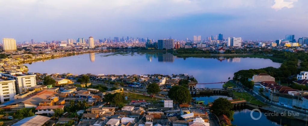
Widodo had hinted at the plan in April, and proponents justify the long-debated move for several reasons. Traffic in Jakarta, home to more than 10 million people, is unwieldy. There are equity issues: Java, the island on which Jakarta sits, is where political and economic power is concentrated. Then there are environmental factors: polluted air, sinking land, and, for the coastal metropolis, a mounting flood risk.
Certain districts of Jakarta, especially near Jakarta Bay, have sunk more than 4 meters since the 1970s, a direct result of excessive and uncontrolled groundwater use. Removing water from layers of soft soils causes the land to compact and settle, like a sponge being squeezed dry. It’s a process called subsidence, and it is jeopardizing the future of a number of coastal cities, especially in Asia: Ho Chi Minh, Hanoi, Semarang, Bangkok, Dhaka, and others.
“In most megacities, groundwater is a major driver of subsidence,” said Gilles Erkens, a subsidence expert at Deltares, a research group based in the Netherlands.
The coasts, particularly delta regions, were a natural setting for urbanization. At the intersection of river and ocean, they connected upstream producers to global markets. It was a successful model, for a time. But a new geography of risk has emerged. Because of climate change and mismanagement of natural resources, coastal cities are increasingly hazardous locations.
Subsidence is one of those risks. Shifting land topples buildings and buckles roads and bridges. It is worsened by unrestrained urbanization on fragile, compactable soils and by upstream dams that block the sediments that replenish delta lands. These sediments, which are also channeled out to sea by levee systems, are “the only natural compensation method available” for land lost to compaction, Erkens told Circle of Blue. And, by engineering design, it has been taken away.
These factors combine to amplify flooding risks from rising seas and storm surges, which are already calamitous. Along the sea wall in Jakarta, a pedestrian looks up, not down, at the waters of Jakarta Bay. Northern districts of the city, those adjacent to the bay, have the worse subsidence and highest flood risk.
In Surat, India, expected to be the world’s fastest-growing city in the next 15 years, some 2 million people, mostly slum-dwellers, could be living in high-risk flood zones by 2070 if subsidence and population growth trends continue, according to an International Institute for Environment and Development report. When the land sinks at the same time that the seas swell, flood disasters become more damaging.
Much of the subsidence that has already occurred is irreversible. But cities can stanch future declines by taking action now, Erkens said. That means restricting groundwater use and finding alternative supplies. Tokyo, which was plagued by high subsidence rates that dropped the city by as much as 4 meters in the early 20th century, built reservoirs and shifted to river water by the 1960s. In Texas, which faced a similar fate in the Houston metro area, the Legislature established a government agency in 1975 to regulate groundwater withdrawals in Harris and Galveston counties. Municipalities gradually shifted to river water from surface reservoirs. Subsidence in those areas has been halted or significantly slowed.
Bangkok today is a city in transition between a subsidence crisis and resolution, Erkens said. City officials instituted a tax on groundwater withdrawals in an attempt to reduce consumption.
These are not quick and easy fixes. Controlling subsidence requires scientific understanding of the interaction between groundwater and land, political will to enforce groundwater restrictions, project planning, and money to carry out the new infrastructure. Still, Erkens sees Tokyo, Houston, and Bangkok as hopeful examples for Jakarta and others.
“Once we get these stories told, other cities will be less reluctant to do something about it,” Erkens said. “It’s possible to take action and have a successful economy.” And, one might add, a capital where the land is stable, at least for a while longer.
Verdant on a late summer evening, Clark’s Marsh, an old bend in the Au Sable River, is a fine spot for a walk, and the river is a fine spot to hook a trout. That natural beauty drew Arnie Leriche to this place.
After Leriche retired from the U.S. Environmental Protection Agency he moved with his partner to Oscoda, the town just downstream from the marsh, with the idea that he would spend his work-free years fishing the clear waters of northern Michigan.
Trouble is, the marsh is just downstream from the former Wurtsmith Air Force Base, where toxic PFAS chemicals have been leaking into groundwater for decades from a field that was formerly used for firefighting training. The groundwater, tainted by foams used to put out the fires, seeped into the marsh, then into the river, and on down the watershed, even into Lake Huron. A few years ago, the Michigan Department of Community Health issued a warning to anglers: Do not eat the fish from the marsh.
Leriche, knowing a bit about pollutants from his years at the EPA, began to worry. Tests showed chemical concentrations in pumpkinseed and bluegill fish to be more than 15 times higher than state standards.
“When I heard the news of ‘Do not eat the fish’ I knew it was more serious than most,” Leriche recalled while walking his golden retriever Molly along a berm in the marsh. “I don’t know if I’d make a comparison to Love Canal,” – an infamous New York waste dump discovered in 1976 that spurred the federal Superfund program – “but it’s so significant that I knew that it was going to be a long-term, hard road for all the agencies and the communities. And, that’s what’s turned out to be over the last five years.”
Wurtsmith is one entry in a long and varied ledger of contaminated sites in Michigan that are contributing to a state groundwater emergency that has spilled over into rivers, streams, and lakes. The extent of this contamination and the failure of state agencies and lawmakers to muster a response equal to the challenge are detailed in a report from FLOW, a Traverse City-based water advocacy group.
Groundwater in Michigan, what FLOW is calling a sixth Great Lake, is “compromised and deteriorated,” the report asserts. Threats come both from legacy sites and current practices: abandoned industrial sites, military bases, dry cleaning facilities, landfills, septic tanks, underground tanks that store petroleum fuels, and fertilizers spread on farm fields. The Michigan Department of Environmental Quality has identified more than 4,000 potential sites where contaminated groundwater and soil could release toxic vapors into buildings. Other connections are just as hard to see. Excessive groundwater pumping in fast-growing Ottawa County has been found to worsen water quality because it pulls deeper, saltier water into wells.
The report criticizes Michigan on two fronts: for inconsistent policies that over decades allowed pollutants to accumulate in groundwater reserves, and for failing to provide adequate funds for cleanup.
“Groundwater is treated as a place where wastes go, not a place to keep wastes out,” Dave Dempsey, the report author, told Circle of Blue.
A concrete pad where firefighting training took place at the former Wurtsmith Air Force Base is ground zero for Oscoda’s PFAS contamination. Foams sprayed here seeped into groundwater that has spread the chemicals to the area’s rivers and lakes. (Photo by J. Carl Ganter/CircleofBlue.org)
A Multitude of Threats
Why write the report now? The timing, Dempsey said. He noted that the discoveries of PFAS chemicals in dozens of locations around the state, from Oscoda in the northeast to Parchment in the southwest, increased public awareness of groundwater, which, in turn, has put pressure on public officials to respond. Second, state elections are in November and a new administration will come to power next year.
“It all adds up to a chance for a new governor to take action on one of our most important water issues,” said Dempsey, a senior adviser at FLOW and environmental adviser in the 1980s to former Gov. James Blanchard.
The to-do list is long, as the FLOW report points out, citing state data. The Michigan Office of the Auditor General found in a March 2017 assessment that the Department of Environmental Quality (DEQ) lacks funds to clean up 7,313 contaminated sites that affect water and soil. The $685 million Clean Michigan Initiative, a bond that voters approved in 1998 to fund the cleanups, ran out of money at the end of 2017. That money was also used to pay the state’s share of Superfund cleanups.
“Without additional funding, contaminated soil and water sites known to DEQ as posing a health risk to humans and the environment will go untreated,” the audit states.
Securing a new funding source is one of outgoing Gov. Rick Snyder’s priorities for the last months of his term. Snyder has proposed an increase to the fee for dumping waste at a landfill, from $0.36 per ton to $4.44 per ton. The fee would generate an estimated $45 million a year for cleanups.
“It would be a welcomed step, if enacted,” Dempsey said, even though FLOW supports another bond measure instead. Still, the dollar amount proposed by the governor is roughly equal to the $50 million a year that FLOW recommends in the report.
Some sites have been left to fester for decades. James Clift, policy director at the Michigan Environmental Council, criticized the Clean Michigan Initiative for prioritizing actions that leave groundwater pollutants in place, essentially fencing them off underground instead of removing them. It may be cheaper and more expedient than removal, but those chemicals can reemerge, sometimes as toxic vapors that waft into building basements.
“We’re not looking at longer-term problems when keeping it in place,” he told Circle of Blue.
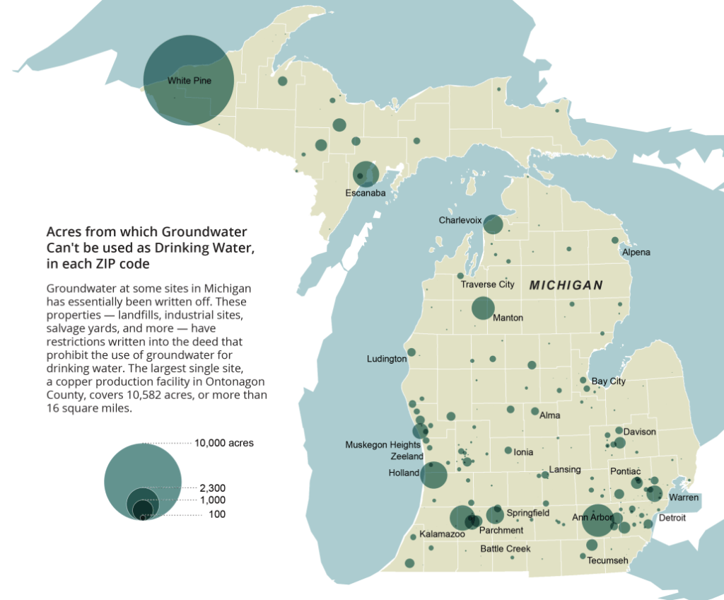
Groundwater at other sites has, in effect, been written off. The state has put restrictions that prohibit the use of groundwater for drinking water on the deeds of 2,239 properties, ranging in size from fractions of an acre to thousands of acres, because of existing contamination.
The scale of the problem can be staggering. In Mancelona, a plume of groundwater laced with trichloroethylene (TCE), a grease cleaner, has spread six miles from a former auto parts manufacturer that operated from 1947 to 1967. It is one of the nation’s largest TCE groundwater contamination sites. Wastewater from the facility was dumped in unlined pits, from which the chemicals percolated into groundwater.
The DEQ, which is funding the cleanup because the company went out of business, estimates that 13 trillion gallons of groundwater, down to depths of 500 feet, have been contaminated. The plume is moving northwestward at roughly 320 to 400 feet per year. The state paid to extend the public water supply system to 500 homes whose wells were tainted.
“It’s always a challenge to have enough staff and resources to address the need,” Andrew Hogarth, former chief of the DEQ remediation and redevelopment division, told Circle of Blue. Hogarth retired nine years ago after managing contaminated site cleanups for the state. New contaminants of concern are always cropping up, which adds to the cost: “PFAS was not even on our radar 20 years ago,” he said, referring to the year in which voters approved the Clean Michigan Initiative.
These slow-moving, widespread contamination zones are a risk especially for the 2.6 million Michigan residents who rely on household wells for drinking water. Well water is unregulated, and it is the homeowner’s responsibility to ensure their water is safe to drink. Dempsey and FLOW recommend a state fund to assist private well owners with water testing, which can cost hundreds of dollars per sample for volatile organic chemicals like TCE.
The report offers a number of other recommendations to protect groundwater, most of which require the Legislature to pass new laws: minimum statewide standards for septic systems or a long-term funding source for cleanups.
Some of the recommendations are vague, such as actions to control nitrate pollution. Neighboring states like Ohio have enacted laws that prohibit spreading manure on snow-covered soil, to reduce the chance of runoff. But agriculture specialists question whether those restrictions will be effective. Farmers will still need to dispose of manure, said Erica Rogers of Michigan State University Extension who works with livestock producers. Holding it back may result in a buildup of manure in storage that needs to be dumped quickly or shipped out of state, she said.
Existing laws do allow for state oversight. Michigan’s Natural Resources and Environmental Protection Act, passed in 1994, defines groundwater as a water of the state that requires protection. The linkage is sometimes ignored in practice, though. State standards for PFOS where groundwater discharges to streams or lakes have not been met in Oscoda.
“The tools are there but the state hasn’t had the political will to apply them as strongly as it could,” Nick Schroeck, an environmental law expert at the University of Detroit Mercy, told Circle of Blue. “Plus the courts and the Legislature have become more skeptical of regulation and see it as a burden on the state economy.”
What is swept underground often does not stay there. Like a river, groundwater moves – and carries pollutants with it, either upward into drinking water wells or outward to rivers and lakes. The U.S. Geological Survey estimates that 35 percent of the water in Lake Michigan originates as groundwater.
“Groundwater is treated like a second-class citizen because the connection to surface water is not seen,” Dempsey said.
Those hydrologic connections are evident in Oscoda, where residents are furious that the state and the Air Force have not done more to halt the flow of PFAS coming from Wurtsmith.
The base is “bleeding,” as residents are keen to say. And they want it stopped.
“We’re based on pure Michigan, right? That’s our motto,” says Cathy Wusterbarth, alluding to the state’s marketing slogan.
Wusterbarth, who was born in Oscoda, helped organize Need Our Water, a local activist group. “We’re the Great Lakes state. I’ve never questions the purity of our Great Lakes until now. When I’ve seen the pumping of this contamination and what I know it does to our health, it has changed my attitude on the preservation of water in our area.”
Tampa Bay Waterkeeper recently announced its Patrol Program. The pollution detecting and reporting initiative is meant to help the organization identify areas of concern so they can take action.
“I’ve found that it can be quite difficult to figure out who to contact, what entity or agency to contact for certain issues,” said executive director Justin Tramble. “The goal of this program is to simplify the process so that there’s no real barrier to reporting things that you see.”
All it takes is a simple scan of a QR code on your phone to report any issues you see while out on the water, including algae blooms, injured wildlife and illegal dumping.
“We’ve lost in Tampa Bay 30 percent of our sea grass since 2016, we’re on a downward trend,” Tramble said. “It’s no secret that we’re not in the greatest place in terms of our water quality. We’re just a few years removed from one of the worst environmental disasters that our region’s ever seen in Piney Point.”
Tramble said Tampa Bay’s water quality directly ties into our area’s economic prosperity. He said the goal of the new reporting initiative is to keep our water fishable, swimmable and drinkable.
So far, Tampa Bay Waterkeeper has gotten more than 100 requests for their QR code stickers from boaters, Tramble said. Over the next couple of weeks, the organization will be distributing the stickers to various businesses – such as marinas, bait and tackle shops and charter companies – to make them as accessible as possible.
“In the past, people have had a hard time really getting involved,” Tramble said. “These big issues are complex. This is a way that’s tangible and attainable for the community to really make a difference and we’re really excited about what this patrol program is going to do.”
Anyone can request a QR code sticker from the organization to access the Patrol Program reporting tool. Learn more about the program.
Tens of millions of Americans live in areas vulnerable to hurricanes and tropical storms, many of whom are far from the coast. Flooding caused by these storms sometimes lasts weeks after they pass, often occurring hundreds of miles inland from where the storm made landfall.
Knowing where flooding is occurring, how significant it might be, and where waters are rising is critical information used to help protect people and communities. The U.S. Geological Survey provides this vital flood data via a nationwide network of more than 11,000 permanent streamgages installed along rivers, streams, lakes, and reservoirs. The USGS also has a smaller network of tide gauges that monitor tidally influenced bodies of water in select parts of the country.
The USGS streamgage network is one of the largest in the world and provides near real-time water levels and flows year-round at many key locations across the nation. USGS stream and tide gauge data on water levels and flows can play a crucial role in shaping critical decisions such as evacuation plans by emergency managers, coastal and inland flood forecasts by the National Weather Service, and flood-control decisions by the U.S. Army Corps of Engineers. The information gained from each storm also improves scientific understanding of storms and advances the USGS’s ability to inform decisions. This can help increase preparedness, reduce risk and enhance resilience for communities potentially affected by hurricanes and tropical storms.
Data from the stream and tide gauge networks are available online on the USGS National Water Dashboard. In addition to stream and tide gauge data, this interactive website also delivers real-time precipitation, atmospheric, water-quality and groundwater data from more than 16,000 USGS observation stations across the country.
To better track flooding events – like those often associated with hurricanes and tropical storms – in areas not monitored year-round by streamgages, the USGS utilizes specialized devices called “rapid deployment gauges.” As the name suggests, these temporary gauges can be installed quickly at critical locations to augment the USGS’s nationwide streamgage network.
Rapid deployment gauges provide near real-time information to the public and emergency managers tracking floodwaters. This can include data on water levels, precipitation, wind speed, temperature, humidity and barometric pressure, and are available on the USGS Flood Event Viewer. This online tool displays rapid deployment gauge locations and data for current and past events.
Come back next week to learn how hurricanes and tropical storms can spread invasive plants and animals through floodwaters and how the USGS estimates their potential spread.
Water resources sustain human development and aquatic ecosystems, but water scarcity is a global issue. Changes in water resource availability such as reduced streamflow or depleted groundwater can cause tension between human water use and ecological needs.Water managers hold a lot of responsibility in balancing these needs, and they rely on our data to make well-informed decisions. At USGS, we detect and quantify changes in water resources. We also have a role to advance understanding of the drivers responsible for those changes. So, we conduct trend studies, which document historical changes in data over time. Trend studies provide essential information to guide water resources management.Water managers need to know the effects of land use, water use, and climate change so they can effectively design water management strategies that better address human and ecosystem needs. In this recently released publication, our scientists outlined the current state of national water availability trend assessments and evaluated ways to advance future trend assessments. They concluded that additional capabilities must be developed and integrated into the assessments. Our scientists recommend potential solutions that could improve the management of water resources:
timely and efficient delivery of trend results the capability to estimate trends in ungaged areas increased understanding of groundwater-surface water interactions better quantification of water use for human needs explicit representation of ecological flow requirements
Our scientists also identified ways researchers could improve the design of the assessments. Researchers need methods to account for how changes in quality affect water supply estimates. They also need methods to develop improved datasets which would distinguish the interrelated impacts of land use, human water use, and climatic influences.
By: GFZ GeoForschungsZentrum Potsdam, Helmholtz Centre
An El Niño event has officially begun. The climate phenomenon, which originates in the tropical Pacific and occurs in intervals of a few years will shape weather across the planet for the next year or more and give rise to various climatic extremes. El Niño-like conditions can also occur on longer time scales of decades or centuries. This has been shown to have occurred in the recent past by an international research team led by Ana Prohaska of the University of Copenhagen and Dirk Sachse of the German Research Centre for Geosciences (GFZ). Their analysis of biomarkers — organic molecules or molecular fossils from vascular plants — in the sediments of a lake in the Philippines indicates an unusually dry phase in the region during the Little Ice Age between 1600 and 1900 A.D. The results have now been published in the journal Communications Earth and Environment. They show how important the understanding of past dynamics of the tropical Pacific ocean-atmosphere climate is for the improvement of climate models and the prediction of future climate changes.
Background: The El Niño phenomenon
A striking feature of climate in the equatorial Pacific is its east-west asymmetry, with warmer surface waters in the west and colder surface waters in the east. Easterly winds drive surface water westwards, allowing equatorial upwelling to bring cooler water to the eastern side. This asymmetry breaks down in today’s climate, leading to El Niño conditions that occur at irregular intervals of a few years and last for 9-12 months.
During an El Niño event, sea surface temperatures along the equator increase from the Peruvian coast to the central Pacific. The southeast trade wind weakens considerably, and light westerly winds may develop. In the western equatorial Pacific, which is otherwise characterised by abundant precipitation, an exceptional dryness takes hold, whereas the otherwise dry eastern edges of the Pacific may experience heavy rainfall.
Against the backdrop of global warming, El Niño is expected to bring record-breaking high temperatures and various extreme climate events globally such as droughts, floods and wildfires, which will significantly affect the lives and well-being of millions of people.
El Niño-like phenomena on longer time scales
While El Niño is an interannual climate phenomenon, the climate system of the tropical Pacific can also exhibit El Niño-like behaviour on longer time scales of decades and centuries, which is linked to the east-west gradient of sea surface temperatures in the Pacific. Such behaviour has been shown to have transpired in the recent past by a team led by Ana Prohaska, assistant professor at the University of Copenhagen and formerly a visiting scientist at the GFZ, and Dirk Sachse, working group leader in GFZ Section 4.6 “Geomorphology” and director of Topic 5 “Landscapes of the Future” of the Helmholtz research programme “Changing Earth — Sustaining our Future,” in the journal Communications Earth and Environment.
They describe such a pronounced shift to El Niño-like conditions in the second half of the Little Ice Age, lasting from about 1630 to 1900 A.D. What is particularly remarkable is the short period of only one generation within which conditions changed for a period of more than 200 years.
Climate insights into the past through studies of sediment cores
The research team examined sediment cores from Lake Bulusan in the northern Philippines, which were collected in 2013. The sediment sequence provides insights into the climatic evolution of the past 1,400 years in a region that is today strongly affected by El Niño events. In particular, the researchers analysed the composition of stable hydrogen isotopes in leaf wax biomarkers (δDwax). These are molecular fossils that originate from the protective surface layer of leaves from vascular plants. The analysis provides insights into water supply during their lifetime.
Drier conditions in the western Pacific during the Little Ice Age
The study shows a sudden and significant increase in δDwax values between 1600 and 1650 A.D., indicating a shift towards drier conditions in the western tropical Pacific during the second half of the Little Ice Age. The researchers attribute this change to a shift in the mean state of the tropical Pacific Ocean related to zonal gradients, i.e., east-west differences in sea surface temperature.
The significance of the current study for climate predictions
Ana Prohaska, lead author of the study, emphasises the importance of this research: “Our study provides compelling evidence for the intricate relationship between zonal gradients in sea surface temperature and hydrological patterns in the tropical Pacific. Understanding the nature and pace of past changes in the tropical Pacific climate system is critical for predicting future climate change and its potential impact on this vulnerable region.”
Dirk Sachse from the GFZ adds: “Although there is increasing evidence that sudden climatic changes have occurred in the past, current climate models cannot reproduce such abrupt shifts in the mean state in the tropical Pacific. This highlights that the understanding of the underlying mechanisms is still limited. In the context of anthropogenic climate change, a better understanding of the drivers and consequences of the complex dynamics of the mean state of the tropical Pacific is of great importance. For this, the integration of palaeoclimatological data into modern climate models plays a crucial role.”
A recent U.S. Supreme Court decision removed federal protections for many wetlands. The Great Lakes region has some state protections but they vary from state to state. But in a watershed like the Great Lakes basin, wetland protections are only as good as the state with the weakest laws.
The Sackett versus EPA case basically rules that if the wetland is directly connected by surface water to a lake or stream, it’s a federally protected part of what’s called the Waters of the U.S. Otherwise, it’s not protected.
That leaves it to each state to decide whether to and how to protect the wetlands that, for 50 years, were protected by the Clean Water Act.
Environmental groups have repeatedly noted that the Supreme Court did not base its decision on scientific evidence, but instead only on private property rights.
On a pleasant day in Ohio, Ray Stewart was sitting on a bench at the Great Egret Marsh, a Nature Conservancy preserve next to Lake Erie. He’s the ambassador for the Ohio Wetlands Association. He was showing me a part of the wetland preserve connected to a lake harbor. It is still protected under the Clean Water Act.
“But if we look over our shoulder here, there is another marshy area that is part of this preserve. And it is it is totally isolated by an embankment surrounding it. But because it doesn’t have a surface connection, then it doesn’t fall under the new definition of Waters of the United States with this recent Sackett v. EPA,” he said.
The two wetlands are equally valuable in helping to filter out contaminants and reducing flooding. Like all wetlands, they’re also among the most productive ecosystems for the organisms at the bottom of the food web as well as for fish, waterfowl, and birds of prey such as bald eagles.
The states, individually, can make laws stronger laws than the federal ones and some of them already have them. But they don’t all have the same level of protections for wetlands. The eight Great Lakes states are a good example.
According to Earth Justice, Minnesota and New York have some of the strongest protections for wetlands in the nation.
Wisconsin, Michigan, Indiana, Ohio, and Pennsylvania have fairly strong protections but they’re all somewhat different.
Michigan in particular will continue protecting wetlands as it has been. It’s had its own program since 1979 and in 1984 the EPA granted the state full authority to continue under state law. That’s rare.
Illinois, again according to Earth Justice, has the weakest wetlands protections in the Great Lakes region.
“A state that’s doing a lot to protect its watershed, if it shares a watershed with another state that is not protecting its watershed, it’s going to likely have negative effects from pollution that’s coming from that other state,” said Jim Murphy, Director of Legal Advocacy at the National Wildlife Federation.
He argued that state protections are not a substitute for uniform federal protections.
He also said states are vulnerable to what’s called the ‘race to the bottom’ to attract economic development.
“When some development goes into the neighboring states, it has weaker protections and starts the narrative of ‘Boy, if we didn’t have these wetlands protections here, we could get that economic activity in our state.’”
Business groups, developers, and farmers are celebrating the Sackett decision.
Brian Turmail is the VP of public affairs for the Associated General Contractors of America. He said the Supreme Court decision cleared up the chaotic way the wetland protections changed from one presidential administration to the next and he added each time it amounted to government overreach.
“The answer isn’t for the executive branch to invent new authorities that Congress didn’t invest in them. The answer is, is for communities, for activists, for anyone who’s interested about particular wetlands, to work with state and local officials to put in place any additional protections they feel are needed on waters that aren’t federal Waters of the U.S.”
The American Farm Bureau Federation did not respond to requests for a comment. In this release, it indicates the Farm Bureau is pleased with the Supreme Court decision.
Back at the Great Egret Marsh, Ray Stewart said, to his mind, Congress needs to amend the Clean Water Act to make it clear that the wetlands near but separate from the Waters of the U.S. are still protected.
“There needs to be a watershed-wide -as a minimum- management of these systems, which is why it’s so important to have a federal program that can look at a broader, more comprehensive view.”
The patchwork of state protections of wetlands is problematic because water doesn’t care about political boundaries. Even wetlands that are not directly connected by surface water with lakes, rivers, and streams, are often connected through groundwater or during floods. Those wetlands are also a buffer that can reduce flooding during the increasingly frequent intense rainstorms that are happening because of climate disruption. If those isolated wetlands near a lake or river are gone, flooding could be worse. And the effects on wildlife are incalculable.
Without protections, more of the small fraction of what’s left of wetlands in the nation could be damaged or destroyed with consequences that reach beyond state borders.
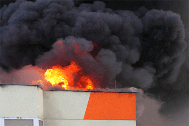
New details about a major accident at a Baltimore wastewater treatment facility that took place earlier this year have revealed its causes and offered some lessons in avoiding similar incidents in the future.
“The explosion that rocked a building at the Back River Wastewater Treatment Plant in March occurred because dust caught fire in a dryer used for sewage sludge, according to a report from the Baltimore City Fire Department,” The Baltimore Sun reported. “After the dryer turned on that morning, a spark ignited the dust, according to the report from the city’s captain of fire investigation. Then, thermal oil used in the dryer was ignited as well.”
CBS News reported that the explosion caused at least $10 million in damages.
Immediately following the explosion, the Maryland Department of the Environment had suggested it was caused by hot oil escaping from a leaking pipe. Nobody was injured in the explosion and this latest investigation has confirmed that it was accidental, but the incident has not helped the plant’s already tenuous reputation.
Following excessive sewage spills into nearby source water, operation of the Back River Wastewater Treatment Plant was taken over by state regulators, though problems persisted. And equipment issues following the explosion seem to have put the facility at risk of failing to meet environmental standards once again.
“After the incident, some key equipment at the building was forced offline, raising questions among environmental advocates whose eyes already were trained on the Back River plant due to its track record of maintenance issues and pollution,” according to the Sun. “But in April — the first full month of data after the explosion — the plant narrowly exceeded its allowable average concentration of phosphorus, a harmful nutrient that promotes the excess growth of algae in waterways.”
Following the release of the fire department investigation, state legislators have opted to continue their oversight of plant operations.
“Maryland regulators have extended supervision of the beleaguered Black River Wastewater Treatment plant through July after Baltimore City reported problems at the facility following an explosion in the spring,” per The Baltimore Banner. “…the state will continue to conduct frequent inspections of the Back River plant, and require the city to take steps to mitigate the effects of the March fire and operate the facility in compliance with its permit.”
As operators attempt to establish a consistent track record at this major Baltimore wastewater treatment facility, they are certainly hoping to avoid any more major setbacks.
To read more about how drinking water and wastewater treatment facilities respond to emergencies, visit Water Online’s Resiliency Solutions Center.